Giro d'Italia: Traffic management scheme begins in NI
- Published
1,700 pink and black information signs are being put up around the route
One of the largest traffic management schemes ever seen in Northern Ireland has begun ahead of next month's Giro d'Italia cycle race.
It is similar in scale to the plan put in place for the G8 summit.
The scheme will involve the closure of more than 200 miles of roads.
The centre of Belfast will be the most affected area, but closures will also be in place on the Causeway coast and in County Armagh during the period Friday 9 May to Sunday 11 May.
The roads will not all be shut at the same time.
Roy Gordon, the Roads Service's traffic manager for Belfast, said there would be rolling road closures.
"Today we've started erecting approximately 1,700 pink and black information signs. These are to inform the public to make sure they can make informed choices as to how to get to the event when the roads close - and if they don't wish to attend the event, how to avoid it," he said.
"Along with last year's G8 summit, this will be the biggest temporary traffic management scheme we've ever had to deal with in Northern Ireland.
"We'll have 200 miles of roads closed, so what we need to do is make the roads safe, and also make sure the travelling public are well aware of all that's going on."
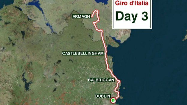
The Giro will be in Northern Ireland for three days:
- Friday 9 May: team time-trial from the Titanic Quarter to Stormont and finishing at Belfast City Hall.
- Saturday 10 May: from Belfast to the Causeway Coast and back, covering more than 130 miles.
- Sunday 11 May: start in Armagh then cross the Irish border to Dublin.
Information about road closures is available on the Department of Regional Development's traffic website.
Details of public transport services during the Giro weekend can be found on the Translink website.
- Published22 April 2014
- Published22 April 2014
- Published22 April 2014
- Published20 March 2014

- Published7 February 2014


