Dit is ons nieuw hondje Kira, een kruising van een waterhond en een Podenko. Ze is sinds 7 februari 2024 bij ons en druk bezig ons hart te veroveren. Het is een lief, aanhankelijk hondje, dat zich op een week snel aan ons heeft aangepast. Ze is heel vinnig en nieuwsgierig, een heel ander hondje dan Noleke.
This is our new dog Kira, a cross between a water dog and a Podenko. She has been with us since February 7, 2024 and is busy winning our hearts. She is a sweet, affectionate dog who quickly adapted to us within a week. She is very quick and curious, a very different dog than Noleke.
DEAR VISITOR,
MY BLOG EXISTS ALREADY 12 YEARS AND 10 MONTHS.
ON 06/04/2024 MORE THAN 1.951.050
VISITORS FROM 134 DIFFERENT NATIONS ALREADY FOUND THEIR WAY TO MY BLOG.
THAT IS AN AVERAGE OF 400GUESTS PER DAY.
THANK YOU FOR VISITING MY BLOG AND HOPE YOU ENJOY EACH TIME.
The purpose of this blog is the creation of an open, international, independent and free forum, where every UFO-researcher can publish the results of his/her research. The languagues, used for this blog, are Dutch, English and French.You can find the articles of a collegue by selecting his category. Each author stays resposable for the continue of his articles. As blogmaster I have the right to refuse an addition or an article, when it attacks other collegues or UFO-groupes.
Druk op onderstaande knop om te reageren in mijn forum
Zoeken in blog
Deze blog is opgedragen aan mijn overleden echtgenote Lucienne.
In 2012 verloor ze haar moedige strijd tegen kanker!
In 2011 startte ik deze blog, omdat ik niet mocht stoppen met mijn UFO-onderzoek.
BEDANKT!!!
Een interessant adres?
UFO'S of UAP'S, ASTRONOMIE, RUIMTEVAART, ARCHEOLOGIE, OUDHEIDKUNDE, SF-SNUFJES EN ANDERE ESOTERISCHE WETENSCHAPPEN - DE ALLERLAATSTE NIEUWTJES
UFO's of UAP'S in België en de rest van de wereld In België had je vooral BUFON of het Belgisch UFO-Netwerk, dat zich met UFO's bezighoudt. BEZOEK DUS ZEKER VOOR ALLE OBJECTIEVE INFORMATIE , enkel nog beschikbaar via Facebook en deze blog.
Verder heb je ook het Belgisch-Ufo-meldpunt en Caelestia, die prachtig, doch ZEER kritisch werk leveren, ja soms zelfs héél sceptisch...
Voor Nederland kan je de mooie site www.ufowijzer.nl bezoeken van Paul Harmans. Een mooie site met veel informatie en artikels.
MUFON of het Mutual UFO Network Inc is een Amerikaanse UFO-vereniging met afdelingen in alle USA-staten en diverse landen.
MUFON's mission is the analytical and scientific investigation of the UFO- Phenomenon for the benefit of humanity...
Je kan ook hun site bekijken onder www.mufon.com.
Ze geven een maandelijks tijdschrift uit, namelijk The MUFON UFO-Journal.
Since 02/01/2020 is Pieter ex-president (=voorzitter) of BUFON, but also ex-National Director MUFON / Flanders and the Netherlands. We work together with the French MUFON Reseau MUFON/EUROP.
ER IS EEN NIEUWE GROEPERING DIE ZICH BUFON NOEMT, MAAR DIE HEBBEN NIETS MET ONZE GROEP TE MAKEN. DEZE COLLEGA'S GEBRUIKEN DE NAAM BUFON VOOR HUN SITE... Ik wens hen veel succes met de verdere uitbouw van hun groep. Zij kunnen de naam BUFON wel geregistreerd hebben, maar het rijke verleden van BUFON kunnen ze niet wegnemen...
28-02-2017
The mysterious Piri Reis Map: Is this evidence of a very advanced prehistoric civilization?
The mysterious Piri Reis Map: Is this evidence of a very advanced prehistoric civilization?
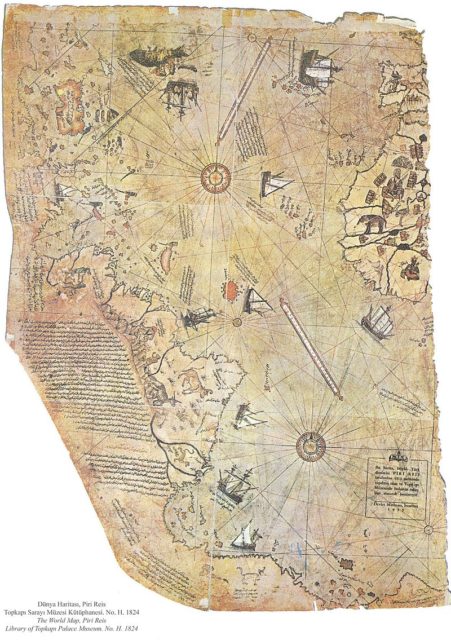
The Piri Reis map is a world map compiled in 1513 from military intelligence by the Ottoman admiral and cartographer Piri Reis.
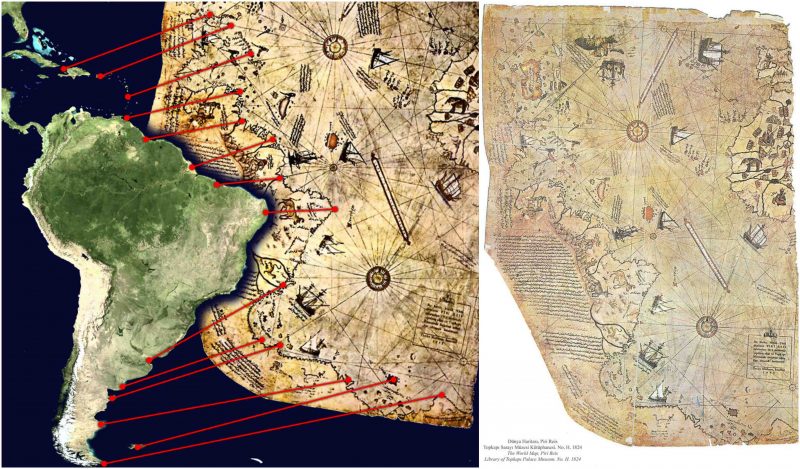
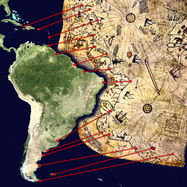
Approximately one third of the map survives; it shows the western coasts of Europe and North Africa and the coast of Brazil with reasonable accuracy. Various Atlantic islands, including the Azores and Canary Islands, are depicted, as is the mythical island of Antillia and possibly Japan.
The historical importance of the map lies in its demonstration of the extent of exploration of the New World by approximately 1510, and in its claim to have used Columbus’s maps, otherwise lost, as a source.
It used ten Arab sources, four Indian maps sourced from the Portuguese, and one map of Columbus. More recently, it has been the focus of pseudo historic claims for the pre-modern exploration of the Antarctic coast.
Surviving fragment of the Piri Reis map showing Central and South America shores. Source
The map was discovered accidentally on 9 October 1929, through the philological work of the German theologian Gustav Adolf Deissmann (1866–1937). He had been commissioned by the Turkish Ministry of Education to catalog the Topkapi Palace library’s non-Islamic items.
At Deissmann’s request to search the palace for old maps and charts, the director Halil Edhem (1861–1938) managed to find some disregarded bundles of material, which he handed over to Deissmann. Realizing that the map might be a unique find, Deissmann showed it to the orientalist Paul Kahle, who identified it as a map drawn by Piri Reis.
The discovery caused an international sensation, as it represented the only then known copy of a world map of Christopher Columbus (1451–1506), and was the only 16th-century map that showed South America in its proper longitudinal position in relation to Africa. Geographers had spent several centuries unsuccessfully searching for a “lost map of Columbus” that was supposedly drawn while he was in the West Indies.
After reading about the map’s discovery in The Illustrated London News, United States Secretary of State Henry L. Stimson contacted the United States Ambassador to Turkey Charles H. Sherrill and requested that an investigation be launched to find the Columbus source map, which he believed may have been in Turkey.
In turn, the Turkish government complied with Stimson’s request, but they were unsuccessful in locating any of the source maps.
The Piri Reis map is currently located in the Library of the Topkapı Palace in Istanbul, Turkey, but is not usually on display to the public.
The map was depicted on the reverse of the Turkish 10 million lira banknote of 1999-2005 and of the new 10 lira banknote of 2005-2009.
The map is a portolan chart, as shown by the four compass roses (two large and two small) from which lines of bearing radiate. Some analyses assert that the map is an a zimuthal equidistant projection centered on Cairo, but a 1998 analysis by Steven Dutch of the University of Wisconsin Green Bay shows a better fit with a point near the intersection of the present-day prime meridian and the equator.
There are extensive notes in Turkish around the edges of the map, as well as some interior detail which is mostly inaccurate and fanciful.
The Iberian peninsula and the coast of Africa are rendered accurately; as for the Americas, the northern portion of the South American coast is also fairly accurate and positioned correctly with respect to Africa. Much of the Caribbean is also mapped fairly accurately and appears to reflect Columbus’s maps of the area.
The area representing North America bears almost no resemblance to its real coastline (which is unsurprising, since by this time, it was still almost totally unexplored) except for one projection which might be Newfoundland; an island labelled “Antilia” may actually be Nova Scotia, since it has a note attached which refers to the legendary voyages of Saint Brendan.
There is some suggestion that this area may represent the Asian coast. Island groups in the east Atlantic are accurately placed, but are depicted out of scale.
Although there are frequent claims for the extreme accuracy of this chart, McIntosh, in comparing the Piri Reis map to several other portolan-style maps of the era, found that
The Piri Reis map is not the most accurate map of the sixteenth century, as has been claimed, there being many, many world maps produced in the remaining eighty-seven years of that century that far surpass it in accuracy. The Ribeiro maps of the 1520s and 1530s, the Ortelius map of 1570, and the Wright-Molyneux map of 1599 (‘the best map of the sixteenth century’) are only a few better-known examples.
The likely explanation of the southern part Piri Reis Map. Source
There are two major discrepancies from known coastlines: the North American coast mentioned above, and the southern portion of the South American coast. On the Piri Reis map, the latter is shown bending off sharply to the east starting around present-day Rio de Janeiro.
A more popular interpretation of this territory has been to identify this section with the Queen Maud Land coast of Antarctica. This claim is generally traced to Arlington H. Mallery, a civil engineer and amateur archaeologist who was a supporter of pre-Columbian trans-oceanic contact hypotheses. Though his assertions were not well received by scholars, they were revived in Charles Hapgood’s 1966 book Maps of the Ancient Sea Kings.
This book proposed a theory of global exploration by a pre-classical undiscovered civilization based on his analysis of this and other ancient and late-medieval maps. More notoriously, these claims were repeated in Erich von Däniken’s Chariots of the Gods (which attributed the knowledge of the coast to extraterrestrials) and Gavin Menzies’s 1421: The Year China Discovered the World (which attributed it to supposed Chinese voyages), both of which were roundly denounced by both scholars and debunkers of fringe works, but which attracted huge popular followings.
A more sober analysis of these claims was published by Gregory McIntosh, a historian of cartography, who examined the map in depth in his book The Piri Reis Map of 1513 (Athens and London: University of Georgia Press, 2000). He was able to find sources for much of the map in Columbus’s writings.
Certain peculiarities (such as the appearance of the Virgin Islands in two locations) he attributed to the use of multiple maps as sources; others (such as the errors in North American geography) he traced to the continued confusion of the area with East Asia. As far as the accuracy of depiction of the supposed Antarctic coast is concerned, there are two conspicuous errors.
First, it is shown hundreds of miles north of its proper location; second, the Drake Passage is completely missing, with the Antarctic Peninsula presumably conflated with the Argentine coast. The identification of this area of the map with the frigid Antarctic coast is also difficult to reconcile with the notes on the map which describe the region as having a warm climate.
It should be kept in mind that maps of the period generally depicted a large continent named Terra Australis Incognita of highly variable shape and extent. This land was posited by Ptolemy as a counterbalance to the extensive continental areas in the northern hemisphere; due to a lack of exploration and various misunderstandings, its existence was not fully abandoned until circumnavigation of the area during the second voyage of James Cook in the 1770s showed that if it existed, it was much smaller than imagined previously.
The first confirmed landing on Antarctica was not until 1820, and the coastline of Queen Maud Land did not see significant exploration before Norwegian expeditions began in 1891. In 1513, Cape Horn had not yet been discovered, and indeed Ferdinand Magellan’s voyage of circumnavigation was not to set sail for another six years.
It is unclear whether the mapmaker saw South America itself as part of the unknown southern lands (as shown in the Atlas Miller), or whether (as Dutch thought) he drew what was then known of the coast with substantial distortion, but in any case, serious scholarship holds that there is no reason to believe that the map is the product of genuine knowledge of the Antarctic coast.
Beste bezoeker, Heb je zelf al ooit een vreemde waarneming gedaan, laat dit dan even weten via email aan Frederick Delaere opwww.ufomeldpunt.be. Deze onderzoekers behandelen jouw melding in volledige anonimiteit en met alle respect voor jouw privacy. Ze zijn kritisch, objectief maar open minded aangelegd en zullen jou steeds een verklaring geven voor jouw waarneming! DUS AARZEL NIET, ALS JE EEN ANTWOORD OP JOUW VRAGEN WENST, CONTACTEER FREDERICK. BIJ VOORBAAT DANK...
Druk op onderstaande knop om je bestand , jouw artikel naar mij te verzenden. INDIEN HET DE MOEITE WAARD IS, PLAATS IK HET OP DE BLOG ONDER DIVERSEN MET JOUW NAAM...
Druk op onderstaande knop om een berichtje achter te laten in mijn gastenboek
Alvast bedankt voor al jouw bezoekjes en jouw reacties. Nog een prettige dag verder!!!
Over mijzelf
Ik ben Pieter, en gebruik soms ook wel de schuilnaam Peter2011.
Ik ben een man en woon in Linter (België) en mijn beroep is Ik ben op rust..
Ik ben geboren op 18/10/1950 en ben nu dus 73 jaar jong.
Mijn hobby's zijn: Ufologie en andere esoterische onderwerpen.
Op deze blog vind je onder artikels, werk van mezelf. Mijn dank gaat ook naar André, Ingrid, Oliver, Paul, Vincent, Georges Filer en MUFON voor de bijdragen voor de verschillende categorieën...
Veel leesplezier en geef je mening over deze blog.


