The purpose of this blog is the creation of an open, international, independent and free forum, where every UFO-researcher can publish the results of his/her research. The languagues, used for this blog, are Dutch, English and French.You can find the articles of a collegue by selecting his category. Each author stays resposable for the continue of his articles. As blogmaster I have the right to refuse an addition or an article, when it attacks other collegues or UFO-groupes.
Druk op onderstaande knop om te reageren in mijn forum
Zoeken in blog
Deze blog is opgedragen aan mijn overleden echtgenote Lucienne.
In 2012 verloor ze haar moedige strijd tegen kanker!
In 2011 startte ik deze blog, omdat ik niet mocht stoppen met mijn UFO-onderzoek.
BEDANKT!!!
Een interessant adres?
UFO'S of UAP'S, ASTRONOMIE, RUIMTEVAART, ARCHEOLOGIE, OUDHEIDKUNDE, SF-SNUFJES EN ANDERE ESOTERISCHE WETENSCHAPPEN - DE ALLERLAATSTE NIEUWTJES
UFO's of UAP'S in België en de rest van de wereld Ontdek de Fascinerende Wereld van UFO's en UAP's: Jouw Bron voor Onthullende Informatie!
Ben jij ook gefascineerd door het onbekende? Wil je meer weten over UFO's en UAP's, niet alleen in België, maar over de hele wereld? Dan ben je op de juiste plek!
België: Het Kloppend Hart van UFO-onderzoek
In België is BUFON (Belgisch UFO-Netwerk) dé autoriteit op het gebied van UFO-onderzoek. Voor betrouwbare en objectieve informatie over deze intrigerende fenomenen, bezoek je zeker onze Facebook-pagina en deze blog. Maar dat is nog niet alles! Ontdek ook het Belgisch UFO-meldpunt en Caelestia, twee organisaties die diepgaand onderzoek verrichten, al zijn ze soms kritisch of sceptisch.
Nederland: Een Schat aan Informatie
Voor onze Nederlandse buren is er de schitterende website www.ufowijzer.nl, beheerd door Paul Harmans. Deze site biedt een schat aan informatie en artikelen die je niet wilt missen!
Internationaal: MUFON - De Wereldwijde Autoriteit
Neem ook een kijkje bij MUFON (Mutual UFO Network Inc.), een gerenommeerde Amerikaanse UFO-vereniging met afdelingen in de VS en wereldwijd. MUFON is toegewijd aan de wetenschappelijke en analytische studie van het UFO-fenomeen, en hun maandelijkse tijdschrift, The MUFON UFO-Journal, is een must-read voor elke UFO-enthousiasteling. Bezoek hun website op www.mufon.com voor meer informatie.
Samenwerking en Toekomstvisie
Sinds 1 februari 2020 is Pieter niet alleen ex-president van BUFON, maar ook de voormalige nationale directeur van MUFON in Vlaanderen en Nederland. Dit creëert een sterke samenwerking met de Franse MUFON Reseau MUFON/EUROP, wat ons in staat stelt om nog meer waardevolle inzichten te delen.
Let op: Nepprofielen en Nieuwe Groeperingen
Pas op voor een nieuwe groepering die zich ook BUFON noemt, maar geen enkele connectie heeft met onze gevestigde organisatie. Hoewel zij de naam geregistreerd hebben, kunnen ze het rijke verleden en de expertise van onze groep niet evenaren. We wensen hen veel succes, maar we blijven de autoriteit in UFO-onderzoek!
Blijf Op De Hoogte!
Wil jij de laatste nieuwtjes over UFO's, ruimtevaart, archeologie, en meer? Volg ons dan en duik samen met ons in de fascinerende wereld van het onbekende! Sluit je aan bij de gemeenschap van nieuwsgierige geesten die net als jij verlangen naar antwoorden en avonturen in de sterren!
Heb je vragen of wil je meer weten? Aarzel dan niet om contact met ons op te nemen! Samen ontrafelen we het mysterie van de lucht en daarbuiten.
06-03-2026
Traveling at 20% The Speed of Light: Scientists Demonstrate ‘Practical’ Light Sails to Explore the Universe
IKAROS, the first space-probe with a solar sail in flight (artist's depiction), featuring a typical square sail configuration of almost 200 m2.
Image credit: By Andrzej Mirecki - Own work, CC BY-SA 3.0, https://commons.wikimedia.org/w/index.php?curid=14656159
Traveling at 20% The Speed of Light: Scientists Demonstrate ‘Practical’ Light Sails to Explore the Universe
Scientists from Tuskegee University, exploring conceptual light sails for interstellar travel, have demonstrated a photonic light-crystal sail design that is more efficient than earlier designs.
Based on the concept of directed energy propulsion, light sails propelled by massive lasers could accelerate unmanned probes to as fast as 20% thespeed of light, enabling missions to nearby stars in a few decades rather than the hundreds of thousands of years conventional chemical rockets would need to reach Earth’s nearest stellar neighbor, Proxima Centauri.
Light Sails Traveling at 20% Light Speed Could Reach Proxima Centauri in 20 Years
To reach space, humans rely exclusively on chemical rockets. To explore beyond Earth’s orbit, those rockets must carry additional fuel. However, adding fuel adds weight, necessitating even more fuel. Engineers have quantified this trade-off with a mathematical tool called the rocket equation.
While some emerging alternatives, such as electric propulsion, enable satellites to maneuver in orbit or even explore deep space, their low speeds also limit the distances they can travel within a human lifetime. The Debrief has covered some sci-fi-sounding alternatives, such as the Wind Rider plasma magnets and warp drives, but those options are either too slow or too theoretical to serve as viable interstellar propulsion systems.
More recently, researchers have explored the concept of light sails. Similar to the more well-known concept of solar sails that “sail” on the pressure of the solar wind, light sails use the energy from a light source to sail at increasingly faster speeds. This design removes the need for onboard propellant.
Some estimates, such as the proposed Breakthrough Starshot initiative, suggest that current technology could design a light-sail-equipped microprobe driven by a powerful laser capable of reaching up to 20% of the speed of light. At that speed, such a probe could reach Proxima Centauri in a little over 20 years.
Light sail by Masumi Shibata, courtesy of Breakthrough Initiatives
While a seemingly practical alternative to chemical propulsion, the practical application of light sails has been limited by engineering challenges. For example, current designs propose metal-coated polymer films. These materials offer a favorable combination of energy reflectivity and strength.
However, these designs also absorb some of the directed energy and convert it into heat. Efforts to capture this wasted heat by increasing reflectivity involve adding materials, thereby increasing weight. As a result, designers of light sails have encountered a tradeoff similar to the rocket equation.
How Photonic Light Crystal Sails Increase Reflectivity and Propulsion
According to a statement announcing the proposed photonic light crystal sail design, the sail’s structure consists of nanoscale patterns from three dielectric components. The first layer is composed of germanium pillars, the second of air holes, and the final layer of a polymer matrix.
Where conventional light sails are made of two material photonic structures, the three-layer dielectric material combination of high-index germanium pillars, low-index air voids, and the polymer host form a wavelength-selective photonic bandgap structure that the research team described as “optimized for propulsion-specific reflectivity.”
Nanoscale features of a laser-driven light sail showing germanium pillars and air holes embedded in a poly(methyl methacrylate) matrix, designed to achieve high wavelength-selective reflectivity. Image Credit: Dimitrov and Harris.
“This configuration establishes a narrow photonic band gap centered at the propulsion wavelength, resulting in high reflectivity within that spectral window while remaining largely transparent outside the designed band,” they explain.
The researchers attributed the exceptional reflectivity of their light sail design to nanoscale patterns in the dielectric materials that control light propagation. They also noted that the ability to arrange materials with different ‘refractive indices,” they were able to create a photonic gap, defined as “a range of wavelengths that cannot pass through the structure and are instead reflected.”
“By designing a narrow photonic band gap aligned with the propulsion laser frequency, the proposed sail can stay mostly transparent to ambient solar radiation while maintaining high reflectivity in the specific operating band,” explained study author Dimitar Dimitrov, an assistant professor at Tuskegee University.
Experiments Confirm Improved Sail Material Performance
To test the concept, the Tuskegee team designed a photonic crystal structure using plane-wave expansion and finite-difference time-domain simulations. After running several simulations, the team achieved approximately 90% reflectivity at a wavelength of 1.2 micrometers.
After the successful simulations, the team fabricated real-world ‘proof-of-concept’ material membranes, such as those used in light sails. Due to the delicate nature of the finished product, the team used electron-beam lithography and vacuum deposition.
“The membranes were fabricated using a sequential nanolithography and material infill process involving patterned polymer templating, selective germanium deposition, lift-off processing, and secondary electron-beam structuring,” they explained.
According to the team, this multi-step fabrication approach allowed them to create three-dielectric photonic crystal architectures “at the sub-200-nanometer scale.” The final versions of the fabricated structures contained 200-millimeter-wide germanium pillars and 400-nanometer-diameter air holes embedded in a 200-nanometer-thick polymer layer.
The team was able to confirm this level of precision engineering and nanoscale patterning with an electron microscope. Dimitrov said demonstrating the feasibility of constructing these precise, multi-dielectric crystal nanostructures was a “key continuation: of the team’s work.
“The results show that these can be engineered to combine low mass, strong wavelength selectivity, and scalable fabrication potential,” the researcher explained.
Devices for Laser-Driven propulsion Enabling Future Interplanetary Exploration
To see if light sails made with their process would maintain reflectivity in simulated spaceflight conditions, the researchers modeled a one-square-meter sail and illuminated it with a 100-kW laser. As hoped, these tests showed that their design could generate continuous thrust. These results also suggested that a light sail made with the three-dielectric material could accelerate a probe to “speeds of several hundred meters per second within one hour under idealized conditions.”
While this speed is far below what would be required for an interstellar mission, the researchers said it is also robust and reflective enough to enable light sails designed for interplanetary missions within our solar system to take a fraction of the time of current rocket-propelled missions. They also concede that further research will be needed before a photonic light crystal sail is deployed in space, while noting that their work “demonstrates a possible pathway from theoretical design to fabrication.”
“Despite current limitations, our research could serve as a foundation for the design and fabrication of multi-dielectric photonic crystal sails,” Dimitrov explained. “It may provide a pathway to experimentally validated, scalable, lightweight devices for laser-driven propulsion, enabling future interplanetary exploration with minimal onboard mass,”
Christopher Plain is a Science Fiction and Fantasy novelist and Head Science Writer at The Debrief. Follow and connect with him on X, learn about his books at plainfiction.com, or email him directly at christopher@thedebrief.org
Astronomers have discovered the brightest and most distant "megamaser" to date. The cosmic energy beam is shooting toward Earth from 8 billion light-years away and was spotted thanks to a weird space-time trick first predicted by Einstein
Researchers have detected a powerful beam of microwaves, or megamaser, coming from a distant galaxy merger around 8 billion light-years from Earth. The rare signal was only detected thanks to a phenomenon known as gravitational lensing, which magnified the incoming radiation.
(Image credit: Inter-University Institute for Data-Intensive Astronomy (IDIA))
Astronomers have discovered a supercharged space laser shooting at Earth from halfway across the universe. The cosmic energy beam, which was partially revealed to us via a weird space-time trick first predicted by Einstein, is the brightest and most distant of its kind ever seen.
The natural laser, called a "hydroxyl megamaser" is essentially a giant beam of electromagnetic radiation emitted when a pair of galaxies violently merge. During these cosmic collisions, giant clouds of gas are compressed, exciting large reservoirs of hydroxyl (OH) molecules that release high-energy microwaves.
This is similar to human-made lasers, which work by exciting particles and then amplifying the resulting light waves with mirrors. But for masers, microwaves are amplified instead of visible light — hence the "M" at the beginning of their name. (Laser is an acronym for "light amplification by stimulated emission of radiation"; replace "light" with "microwave" and you get a maser.)
Researchers are particularly interested in megamasers because they can shed light on how ancient galaxies form, grow, evolve and die. As a result, they are often dubbed "cosmic beacons."
In a new study, uploaded Feb. 13 to the preprint server arXiv and accepted for future publication in the journal Monthly Notices of the Royal Astronomical Society: Letters, researchers using the MeerKAT telescope — an array of 64 radio dishes located in South Africa — discovered a new hydroxyl megamaser coming from a pair of colliding galaxies dubbed HATLAS J142935.3–002836.
The megamaser coming from HATLAS J142935.3–002836 was detected by the MeerKAT telescope in South Africa, which is made up of 64 linked radar dishes. (Image credit: SARAO/MeerKAT)
The microwaves shooting out of this system are very stretched, around 18 centimeters in length (7 inches or 1,665 megahertz), and are so much brighter than other megamasers that the researchers have proposed that the signal should be classified as a "gigamaser" — the next theoretical order of magnitude for these space lasers.
"Truly extraordinary"
HATLAS J142935.3–002836 was first discovered in 2014 and is around 8 billion light-years from Earth, meaning the microwaves we see were emitted when the universe was about half its current age. This comfortably makes it the most distant megamaser seen to date.
"This system is truly extraordinary," study first author Thato Manamela, an astronomer at the University of Pretoria in South Africa, said in a statement. "We are seeing the radio equivalent of a laser halfway across the universe."
Normally, signals from so far away are too faint to be picked up by telescopes like MeerKAT. However, the maser shooting from HATLAS J142935.3–002836 has been further amplified by a rare phenomenon, dubbed gravitational lensing, which was first predicted by Albert Einstein's theory of relativity in 1905.
HATLAS J142935.3–002836 is only visible to us thanks to a phenomenon known as gravitational lensing. These 2014 images, captured by the Hubble Space Telescope (left) and the Atacama Large Millimeter/submillimeter Array (ALMA) telescope (right), show a partial "Einstein ring" of magnified light from the distant galaxy merger. (Image credit: ALMA (ESO/NAOJ/NRAO)/NASA/ESA/W. M. Keck Observatory)
Gravitational lensing occurs when electromagnetic radiation from a distant object, such as a galaxy, is bent around a massive object positioned directly between the source and the observer. Obviously, the radiation doesn't actually bend (because light always travels in a straight line): Instead, it passes through warped space-time that has been pulled out of shape by the immense gravity of the middle object.
The team is now planning to point MeerKAT at similar systems in the hopes of discovering more secret megamasers or gigamasers lurking within gravitationally lensed objects, which could drastically increase the number of these otherwise rare space lasers they can study.
"This is just the beginning," Manamela said. "We don't want to find just one system — we want to find hundreds to thousands."
De Betty en Barney Hill Ontvoering: Amerika’s Eerste UFO-ontvoering Die Alles Veranderde
Betty en Barney Hill Ontvoering | De Eerste Buitenaardse Ontmoeting Die Amerika Veranderde
De Betty en Barney Hill Ontvoering: Amerika’s Eerste UFO-ontvoering Die Alles Veranderde
Op 19 september 1961 maakten Betty en Barney Hill, een gemengd getrouwd echtpaar uit Portsmouth, New Hampshire, een gebeurtenis die de manier waarop de Verenigde Staten en de wereld naar het onbekende keken voor altijd zou veranderen. Wat begon als een gewone autorit door de White Mountains, werd het toneel van de eerste officieel gedocumenteerde UFO-ontvoering in de Amerikaanse geschiedenis. Deze gebeurtenis zette een nieuwe standaard voor het begrijpen van buitenaardse ontmoetingen, introduceerde concepten die decennia lang de UFO-onderzoeken zouden domineren en beïnvloedde de populaire cultuur op een onvoorstelbare manier.
In dit artikel nemen we je mee op een uitgebreide reis door de gebeurtenissen van dat bewuste nacht, de achtergronden van het echtpaar, de fysieke en psychologische bewijzen, de wetenschappelijke en maatschappelijke gevolgen en de blijvende erfenis van de Betty en Barney Hill-zaak. We bespreken alles dat nodig is om te begrijpen waarom deze gebeurtenis niet alleen een mysterie is, maar ook een venster op de complexiteit van menselijke perceptie, collectief geheugen en culturele invloed.
De Nacht Die Alles Veranderde: 19 september 1961
Het begon als een gewone reis. Betty en Barney Hill waren op weg van hun vakantie in Niagara Falls terug naar huis in Portsmouth, New Hampshire. Ze waren ongeveer drie uur onderweg langs Route 3 door de White Mountains, toen ze plots een opvallend, helder licht aan de hemel zagen dat hun aandacht trok. Betty, een sociale werker, en Barney, een postbode en burgerrechtenactivist, waren geen onbekenden met het observeren van vreemde verschijnselen; ze hadden eerder lichtverschijnselen en onverklaarbare objecten gezien, maar niets bereikte de intensiteit en het detail van wat hen die avond overkwam.
Het licht leek zich te gedragen als een ster, maar beweegde onregelmatig en leek te volgen op een manier die niet overeenkwam met gewoon luchtverkeer. Betty merkte op dat het object, dat aanvankelijk erg klein leek, langzaam dichterbij kwam en uiteindelijk de vorm aannam van een grote, ronde schijf met verlichte ramen en humanoïde figuren zichtbaar door een verrekijker. Barney, nieuwsgierig en bezorgd, haalde zijn verrekijker tevoorschijn en observeerde het fenomeen nauwkeurig. Wat hij zag, was een gestructureerd vaartuig van 12 tot 18 meter doorsnede, met rijen lichtende ramen waarbinnen humanoïde wezens zich bewogen.
Wat daarna gebeurde, markeerde een keerpunt in de geschiedenis van UFO-onderzoek: de twee getuigen herinnerden zich later dat ze werden meegenomen aan boord van het ruimteschip, waar ze medische onderzoeken ondergingen en telepathisch communiceerden met de buitenaardse wezens. Deze herinneringen werden later bevestigd door hypnotische regressie en vormen sindsdien het basispatroon van het moderne abductieverhaal.
Universal History Archive/UIG via Getty Images Barney en Betty Hill waren een Amerikaans koppel dat naar verluidt door buitenaardse wezens werd ontvoerd.
De Achtergrond van Betty en Barney Hill
Het bijzondere aan dit verhaal is niet alleen de gebeurtenis zelf, maar ook wie Betty en Barney waren. In 1961 was een gemengd huwelijk nog bijzonder en controversieel. Betty, een witte vrouw uit Newton, New Hampshire, was werkzaam als sociaal werker en actief in de burgerrechtenbeweging. Barney, een Afro-Amerikaanse postbode, was betrokken bij de NAACP en streed voor gelijke rechten. Hun relatie was een daad van moed in een tijd van raciale segregatie en discriminatie.
Betty kwam uit een middenklassefamilie en had een opleiding gevolgd, waardoor ze een gerespecteerde rol in haar gemeenschap had. Barney was een trotse en actieve burgerrechtenstrijder, die niet alleen voor gelijke rechten vocht, maar ook een voorbeeld was binnen hun gemeenschap. Hun sociale status en reputatie gaven hun getuigenis een zekere geloofwaardigheid, ondanks de ongeloofwaardigheid van het verhaal zelf.
De Reis Van Montreal Naar Portsmouth
De reis begon op 19 september 1961 na een vakantie in Montreal. Het was een donkere, rustige avond. Betty en Barney reden langs Route 3, een bekende route door de White Mountains, en waren zich niet bewust van het onheil dat zou volgen. Rond 22:30 uur zagen Betty een helder, sterachtig object dat zich anders gedroeg dan een gewoon hemellichaam. Aanvankelijk dacht Betty dat het een satelliet of een vliegtuig was, maar al snel werd duidelijk dat het object ongewoon gedrag vertoonde en zich op een onverklaarbare manier bewoog.
Het eerste waarneming was relatief onschuldig: een licht dat in de hemel verscheen en zich leek te bewegen. Maar naarmate Barney de verrekijker gebruikte en het object beter kon bekijken, veranderde de sfeer. Het vaartuig kreeg een gestructureerde vorm met lichtende rijen ramen en humanoïde figuren die binnen zichtbaar waren. Barney beschreef de wezens als kleine, grijze, humanoïde vormen met grote, zwarte ogen. Het was het begin van een ervaring die hun leven voor altijd zou beïnvloeden.
Wat gebeurde er die avond precies?
Het mysterieuze object bleef enkele minuten observeren, terwijl Betty en Barney zich ongemakkelijk begonnen te voelen. Toen het vaartuig begon te dalen en richting hun auto kwam, werden ze achtervolgd door een gevoel van angst. Barney haalde zijn verrekijker uit het dashboard en richtte die op het object. Wat hij zag, was een gestructureerd schip met ramen en menselijke figuren die hem aankeken. Op dat moment voelde Barney een plotselinge angst die hem verlamde, terwijl Betty zich eveneens angstig begon te voelen.
Het bizarre is dat ze zich later niet meer konden herinneren wat er precies gebeurde tijdens de volgende uren. Ze hadden een periode van ongeveer twee uur waarin hun herinneringen ontbraken. Pas later, onder hypnose, zouden ze details terugkrijgen over de medische onderzoeken, de communicatie met de buitenaardse wezens en de terugkeer naar hun auto.
Charles Walker Collection/Alamy Stock Photo
Dr.Benjamin Simon conducting hypnosis therapy on Betty and Barney Hill.
De "Missing Hours en Physical Evidence"
Het meest opvallende aspect van hun verhaal is de zogeheten 'missing time' — de periode waarin ze geen herinneringen hadden aan wat er gebeurde. Toen Betty en Barney na hun reis thuiskwamen, ontdekten ze dat er iets niet klopte. Hun auto vertoonde onverklaarbare sporen: cirkelvormige inscripties op de motorkap, beschadigingen aan de antenne, en kleine metalen deeltjes in de verf die niet konden worden verklaard door normale slijtage. Betty’s jurk vertoonde scheuren en een roze poeder dat niet te identificeren was. Barney’s schoenen hadden mysterieuze schrammen.
Ze waren uitgeput, verward, en hadden een gevoel dat ze iets buitenaards hadden meegemaakt. Ze hadden ook fysieke klachten: Betty had een pijnlijke, brandende plek op haar huid, en Barney voelde zich erg moe en verward. Het feit dat hun horloges waren gestopt en dat er fysieke sporen op hun auto en kleding waren, gaf het verhaal meer geloofwaardigheid.
Onderzoek en Hypnose
De eerste reactie van Betty en Barney was om medische hulp te zoeken en contact op te nemen met de militaire autoriteiten. Op 21 september 1961 rapporteerden ze hun waarneming aan Pease Air Force Base, die de zaak serieus nam. De militaire autoriteiten begonnen een onderzoek, dat later onderdeel werd van Project Blue Book, het Amerikaanse programma dat UFO-waarnemingen onderzocht.
In de daaropvolgende jaren werden Betty en Barney onder hypnose gebracht door de bekende psychiater Dr. Benjamin Simon. Tijdens deze sessies, begin jaren 60, gaven Betty en Barney gedetailleerde beschrijvingen van de wezens, de ruimtevaartuigen, en de medische onderzoeken. Betty herinnerde zich een driedimensionale sterrenkaart die ze had gezien aan boord van het schip, die later werd bestudeerd door astronomen.
Universiteit van New Hampshire
De UFO gezien door Betty en Barney Hill, zoals getekend door Betty Hill..
De Beschrijvingen van de buitenaardse wezens
De getuigenissen onder hypnose onthulden dat de wezens ongeveer 1,20 tot 1,50 meter groot waren, met grote, zwarte ogen en een grijze huid. Ze droegen strakke, donkere uniforms en vertoonden hiërarchisch gedrag, waarbij één figuur leek op de leider. De communicatie verliep via telepathie, waarbij de wezens geruststellende gedachten overbrachten en geen gesproken taal gebruikten.
De medische onderzoeken omvatten het nemen van haar- en huidmonsters, het inbrengen van een dunne naald in Betty’s navel (wat later werd geïnterpreteerd als een zwangerschapstest) en het afnemen van biologische monsters. Onder hypnose herinnerden Betty en Barney zich dat ze werden onderzocht op een medische tafel in een ruimte met vreemde instrumenten.
De Star Map en de Betekenis
Betty herinnerde zich dat ze aan boord van het schip een sterrenkaart had gezien, die ze later probeerde te tekenen. Haar tekening werd later bestudeerd door amateur-astronoom Marjorie Fish, die suggereerde dat de kaart mogelijk de Zeta Reticuli-sterrenstelsel vertegenwoordigde, ongeveer 39 lichtjaar van de aarde. Hoewel deze interpretatie controversieel is, blijft de sterrenkaart een van de meest besproken elementen van de zaak.
Charles Walker Collection/Alamy Stock Photo Een artistieke weergave van de buitenaardse wezens zoals beschreven door Barney en Betty Hill.
De beschrijvingen van de aliens en de technologie werden onderdeel van de archetypische 'Gray' -alien en vormen sindsdien de basis voor talloze abductieverhalen en popcultuur.
De Reproductie van de Sterrenkaart en de Betekenis
Betty’s tekening van de sterrenkaart werd een belangrijk document. Fish bouwde een driedimensionaal model dat leek overeen te komen met bepaalde nabijgelegen sterrenstelsels. Deze vondst gaf de zaak een wetenschappelijke dimensie, maar werd door de meeste astronomen betwist omdat de interpretatie van de kaart te selectief was en geen sluitend bewijs bood voor buitenaardse afkomst.
Schematic from Betty Hill's sketch
Marjorie Fish's interpretation applied to Betty's schematic
Legend:
1) Zeta 1 Reticuli
5) Gliese 86
9) Kappa Fornacis
D) 107 Piscium
2) Sun
6) Gliese 59
A) Tau 1 Eridani
E) 54 Piscium
3) Alpha Mansae
7) Gliese 86.1
B) 82 Eridani
F) Gliese 67
4) Zeta 2 Reticuli
8) Gliese 95
C) Tau Ceti
Betty Hill-kaart en Marjorie Fish-interpretatie
De Impact op de Maatschappij en UFO-onderzoek
De publicatie van het boek The Interrupted Journey door journalist John Fuller in 1966 bracht de zaak in de mainstream. Het boek bevatte transcripties van hypnotische sessies, medische rapporten en uitgebreide analyses. Het werd een bestseller en zette de basis voor het moderne abduction-genre.
De zaak leidde ook tot een televisiefilm in 1975, The UFO Incident, met James Earl Jones en Estelle Parsons, die de gebeurtenissen dramatiserden en miljoenen kijkers bereikten. Dit maakte Betty en Barney Hill beroemdheden en veranderde de perceptie van UFO's in de Amerikaanse samenleving.
De rol van skeptici en onderzoekers
Niet iedereen was overtuigd van de echtheid van de verhalen. Skeptici wezen op de mogelijke rol van slaapverlamming, nachtrusttekort, suggestieve hypnotische technieken en culturele invloeden zoals sciencefictionfilms. Psychologen benadrukten dat herinneringen onder hypnose gemakkelijk kunnen worden vervormd of geïmplant. De sterrenkaart werd vooral als toeval of confirmatiebias gezien.
Aan de andere kant zagen gelovigen in de zaak een bewijs van echte buitenaardse contacten en gebruikten ze de details van de beschrijvingen en fysieke bewijzen om hun overtuiging te versterken.
De Betekenis van de Zaak
De Betty en Barney Hill-ontvoering markeerde een keerpunt in de geschiedenis van UFO-onderzoek. Het introduceerde het concept van abducties, het idee dat buitenaardse wezens mensen ontvoeren voor medische experimenten en genetisch onderzoek. Het legde ook de basis voor het archetype van de 'Gray' -alien en de typische medische onderzoeken die in talloze latere verhalen terugkeren.
Daarnaast had de zaak een grote maatschappelijke impact: het was een van de eerste keer dat een gemengd huwelijk publiekelijk getuigde van een buitenaardse ontmoeting, wat een brug sloeg tussen sociale taboes en het universele mysterie van het onbekende.
De Kritiek en de Hedendaagse Reflectie
Sinds de jaren 60 is de zaak uitvoerig bestudeerd en bekritiseerd. Moderne psychologie en neurowetenschap tonen aan dat herinneringen, vooral onder hypnose, niet betrouwbaar zijn en gemakkelijk kunnen worden vervormd door suggestie en culturele invloeden. De fysieke bewijzen, zoals de mysterieuze vlekken op de auto en de metalen deeltjes, werden nooit definitief bevestigd of verklaard.
Tegelijkertijd blijft de zaak een krachtig symbool voor de menselijke zoektocht naar het onbekende en een voorbeeld van hoe verhalen over buitenaardse ontmoetingen worden gevormd door een complexe interactie van psychologie, cultuur en wetenschap.
De Nieuwe Wetenschappelijke Inzichten
Tegenwoordig begrijpen we dat menselijke herinneringen malleus zijn en dat suggestieve technieken zoals hypnose de neiging hebben om valse herinneringen te creëren. De theorie van 'false memory syndrome' wijst op de kracht van de geest om overtuigende maar onware verhalen te fabriceren, vooral onder druk of suggestie.
Daarnaast verklaren technologische en militaire ontwikkelingen in de jaren 50 en 60 dat veel waarnemingen en fenomenen kunnen worden toegeschreven aan geheime vliegtuigprojecten, zoals de U-2 en de SR-71, of aan experimentele technologie die pas later werd bekendgemaakt.
De rol van geheime militaire projecten
In de jaren 60 ontwikkelden de Amerikaanse luchtmacht en defensie-instellingen geavanceerde vliegtuigen en technologieën die voor de burgerwereld onzichtbaar waren. Sommige van deze projecten produceerden ongewone vliegbewegingen en geluiden die door getuigen als buitenaardse verschijnselen werden geïnterpreteerd. De geheime testvluchten over de White Mountains en de regio rond Portsmouth kunnen dus een belangrijke rol hebben gespeeld in de waarnemingen van Betty en Barney.
De conclusies en de blijvende vraagstukken
Ondanks de uitgebreide onderzoeken, de technologische verklaringen en de psychologische analyses, blijven veel vragen onbeantwoord. Was het een echte ontmoeting met buitenaardse wezens? Of een complex samenspel van suggestie, culturele invloeden en geheime militaire experimenten? Of misschien een combinatie van beide?
De zaak blijft een fascinerend voorbeeld van hoe menselijke perceptie, geheugen en cultuur de realiteit kunnen vervormen, vooral bij het omgaan met het onverklaarbare.
De Erfenis en de Betekenis Vandaag
De Betty en Barney Hill-zaak heeft niet alleen de UFO-gemeenschap gevormd, maar ook de manier waarop we denken over geheugen, perceptie en bewijs. Het heeft de dialogen geopend over de betrouwbaarheid van herinneringen, de invloed van cultuur en media, en de grenzen van wetenschappelijke kennis over het onbekende.
Ze symboliseren ook de moed van een gemengd paar dat, ondanks maatschappelijke druk en persoonlijke angsten, besloot hun verhaal te delen. Hun verhaal blijft een krachtig symbool van menselijke nieuwsgierigheid en het verlangen om het universum te begrijpen.
Conclusie
De ontvoering van Betty en Barney Hill op 19 september 1961 markeerde een keerpunt. Het was de eerste keer dat een dergelijk verhaal op grote schaal werd gedocumenteerd, onderzocht en publiekelijk besproken. Het stelde belangrijke vragen over de aard van herinneringen, de betrouwbaarheid van getuigenissen onder hypnose en de mogelijkheid van buitenaardse intelligentie.
Hoewel veel aspecten van hun verhaal wetenschappelijk worden betwijfeld, heeft de zaak een blijvende invloed op de cultuur, de wetenschap en de manier waarop wij het onbekende benaderen. Het is een verhaal dat ons uitdaagt om verder te kijken dan de bekende horizon, om kritisch te blijven, maar ook om open te staan voor de mysteries die nog altijd in het heelal en in onze eigen geest verborgen liggen.
De Betty en Barney Hill-zaak blijft zo een ultiem symbool voor de menselijke zoektocht naar waarheid, begrip en de grenzen van onze perceptie. Het herinnert ons eraan dat, ondanks alle wetenschap en technologie, het onbekende altijd een stukje verder ligt, wachtend om ontdekt te worden.
GERELATEERDE VIDEO'S
{ PETER2011 }
05-03-2026 om 22:51
geschreven door peter
0
1
2
3
4
5
- Gemiddelde waardering: 0/5 - (0 Stemmen) Categorie:ALIEN LIFE, UFO- CRASHES, ABDUCTIONS, MEN IN BLACK, ed ( FR. , NL; E )
2026 – A Year of Unprecedented Focus, History, and Ongoing Research in UFO and UAP Studies: The Oz Files
2026 – A Year of Unprecedented Focus, History, and Ongoing Research in UFO and UAP Studies: The Oz Files
Introduction and Overview
The year 2026 marks a significant turning point in the global exploration, analysis, and understanding of Unidentified Aerial Phenomena (UAP), commonly known as UFOs. This pivotal year is characterized by a series of commemorative events, renewed scholarly research initiatives, and a surge in public and governmental interest, all pointing toward a transformative era in UAP investigation. The confluence of anniversary celebrations, innovative fieldwork, and high-level official commentary signals what many experts consider a historic juncture in human interaction with the mysterious aerial phenomena that continue to challenge conventional scientific paradigms.
In particular, Australia stands at the forefront of this movement, commemorating the 60th anniversaries of two landmark incidents—the Westall UFO encounter of February 1966 and the Tully “saucer‑nest” event of July 1966. These anniversaries are not only moments for reflection but also catalysts for renewed investigation, documentation, and public engagement. Meanwhile, in Europe and North America, researchers are expanding the archival record, employing advanced technologies, and fostering multidisciplinary approaches to better understand four distinct categories of aerial anomalies.
This comprehensive overview explores the key milestones, ongoing initiatives, classification challenges, and future outlook of UFO and UAP research in 2026, emphasizing the rich historical context and the evolving scientific landscape that underpin this unprecedented year.
Anniversary Milestones and Commemorative Events
The anniversaries of the Westall and Tully incidents serve as focal points for both public fascination and scholarly inquiry. These events have been deeply ingrained in Australian UFO lore, symbolizing early encounters with unexplained aerial phenomena and inspiring generations of researchers and enthusiasts.
1. Westall Incident (February 1966): This event involved a large crowd of students, teachers, and local residents witnessing a strange flying object near Melbourne. Despite initial skepticism, the incident has gained renewed attention through documentaries, interviews, and academic studies. The 60th anniversary in 2026 has prompted a series of public programs aimed at distinguishing eyewitness testimony from folklore, and at examining physical traces and radar data that may support the accounts.
2.Tully “Saucer-Nest” (July 1966):
One of Australia’s most famous UFO sightings, the Tully case involved multiple witnesses reporting a glowing, saucer-shaped craft that allegedly nested in the rainforest for several hours. Photographs by George Pedley, as well as sketches and contemporary footage, are being showcased at the Australian UFO Festival held in Cardwell, Queensland, from August 6 to 9, 2026. These visual materials serve as vital historical artifacts and investigative tools, bridging the original reports with modern scientific standards.
3. Public Engagement and Academic Discourse: In Melbourne and Sydney, university-affiliated panels and community forums are bringing together eyewitnesses—former teachers, police officers, and local residents—to share their recollections. These discussions aim to separate verified data from folklore, creating a more robust dataset for future research. Additionally, local museums and archives are hosting exhibitions featuring photographs, sketches, and declassified documents to educate the public and foster transparency.
Expanding Research Initiatives and International Collaboration
The academic and investigative landscape in 2026 is marked by a surge in systematic research efforts, leveraging new technologies and international partnerships.
The Hessdalen Lights Project: One of the most prominent ongoing investigations is the Hessdalen Lights project in Norway. This initiative involves a consortium of atmospheric scientists, physicists, and UAP investigators who have launched a dedicated podcast series—produced in collaboration with Norwegian research institutions. The latest episodes focus on cataloging nightly luminous phenomena using high-resolution infrared imaging and spectrometry. Dr. Eirik Larsen, lead researcher, emphasizes that these light events form a natural laboratory for understanding low-altitude luminous anomalies that might share underlying physics with other UAP reports worldwide.
European Archival and Data Collection Efforts: In Scandinavia, archivist Clas Svahn has digitized extensive Cold War-era radar logs, military memos, and civilian sighting reports from Sweden, Denmark, and Norway. Hosted on an open-access platform, this database contains over 3,000 entries—many of which have never been examined or published in scientific literature. This effort aims to provide a comprehensive, searchable repository that can facilitate cross-referencing and pattern analysis, enabling researchers to identify trends and anomalies across decades and regions.
North American and UK Initiatives: Across the Atlantic, the United Kingdom’s UAP research community has gained momentum. Nick Pope, a former UK Ministry of Defence analyst, has publicly characterized 2026 as a “historic moment” for humanity’s relationship with the unknown. Now heading the UAP research unit at the UK Defence Science and Technology Laboratory, Pope highlights recent congressional hearings and the Pentagon’s 2023 UAP report as evidence that government secrecy is giving way to transparent, multidisciplinary inquiry. Such developments are fostering increased cooperation between military, scientific, and civilian organizations.
Governmental and Military Interest: The United States continues to lead in official investigations, with the Pentagon’s Unidentified Aerial Phenomena Task Force (UAPTF) releasing declassified reports and encouraging civilian collaboration. Congressional hearings have brought UAP issues into mainstream political discourse, prompting calls for standardized data collection and international cooperation on a scientific basis.
Is a UAP a UFO? NASA's new team investigating the unknown
The Classification Challenge: Understanding the Four Phenomena Types
Despite growing interest and data, the field continues to face a fundamental classification challenge—distinguishing among different types of aerial phenomena and understanding their underlying nature.
The community now generally recognizes four primary categories:
Instrument-Verified Aerial Objects: Objects detected through corroborated sensor data, such as radar, infrared imaging, or other instrumentation, providing objective evidence of physical presence and movement.
Visual Sightings with Corroborating Radar Data: Eyewitness accounts supported by radar tracks, often involving military or civilian observers who report consistent observations across multiple modalities.
Luminescent Ground-Based Events: Phenomena like the Hessdalen Lights or similar ground-based luminous events that are often characterized by their spontaneous appearance, high luminosity, and often mysterious physics.
Cultural-Psychological Reports: Accounts influenced by media reports, folklore, or psychological factors, which may not involve physical phenomena but contribute to the overall understanding of public perception and mass psychology related to UAP.
Each category demands an appropriate methodological approach—from high-resolution infrared and radar analysis to sociological surveys and psychological profiling. The challenge lies in developing a unified scientific framework capable of integrating these diverse data sources into a coherent understanding.
Australian Case Studies and Classification: The Westall incident, primarily documented through eyewitness testimony and limited radar data, falls into the fourth category—cultural-psychological reports—highlighting the importance of contextual analysis. Conversely, the Tully “saucer-nest” involves physical impressions on the ground and military documentation, aligning more with instrument-verified and corroborated sightings.
By studying these contrasting cases side by side, researchers aim to refine criteria for what constitutes credible, scientifically investigable evidence, moving beyond anecdotal reports toward objective, reproducible data.
Outlook and Community Sentiment for 2026 and Beyond
The increasing volume and quality of data, combined with governments’ willingness to declassify and share information, have fostered cautious optimism among UAP researchers and the interested public.
Public Engagement and Policy Developments: The momentum generated by international collaborations, archival releases, and academic conferences suggests that the next phase of UAP research will be characterized by increased transparency, standardized data collection, and technological innovation. Governments worldwide are starting to acknowledge the importance of understanding these phenomena—not merely for scientific curiosity but also for national security and technological advancement.
Scientific and Technological Advances: Physicist Albert Pennisi, who recently presented on electromagnetic signatures associated with UAP, notes that “the interdisciplinary dialogue we’re seeing now was unimaginable three decades ago.” His statement echoes the sentiments of many in the field: while sensational headlines still dominate media narratives, rigorous scientific inquiry is gaining ground.
Potential Breakthroughs and Challenges: While some observers speculate that this convergence might lead to tangible policy changes, technological breakthroughs, or even contact, others caution that the phenomena remain elusive and complex. Nonetheless, the historical and ongoing efforts in 2026 set a foundation for a more systematic, credible approach to studying the unknown.
The question remains whether this “historic moment,” as Nick Pope describes it, will translate into lasting scientific insights, policy shifts, or technological innovations. The signs are promising, and the momentum is undeniable, marking a new era in humanity’s quest to understand the mysterious aerial phenomena that have fascinated and perplexed us for generations.
In Summary: 2026 stands out as a landmark year in the history of UFO and UAP research, characterized by commemorative milestones, innovative scientific investigations, expanded archival resources, and a global community increasingly committed to rigorous, multidisciplinary inquiry. As these efforts continue to unfold, they promise to reshape our understanding of the skies and our place within the broader universe—whether these phenomena are extraterrestrial, atmospheric, or psychological in origin remains to be fully understood, but the journey toward that understanding has never been more active or promising.
Former US Air Force general linked to UFO research goes missing in New Mexico
Former US Air Force general linked to UFO research goes missing in New Mexico
Disappearance of Air Force veteran William Neil McCasland sparks concern as silver alert issued and sheriff’s office appeals to public for information on his whereabouts
A trove of controversial UFO documents describing a secret government group tasked with recovering alien spacecraft may be authentic after all.
A researcher claims the long-debated Majestic-12 (MJ-12) papers, dismissed for decades as fake by the FBI, contain official intelligence filing numbers that match real CIA records from the same era.
The documents allege that a group of 12 high-ranking military and scientific officials secretly spent more than two decades investigating crashed alien craft, studying non-human technology and attempting to communicate with extraterrestrials.
The anonymous investigator said the breakthrough came after comparing administrative stamps and file numbers on the MJ-12 papers with those found on publicly released CIA documents from the 1940s and 1950s.
According to the theory, the numbering systems and classification markings used on the controversial UFO papers match formats once used by the US intelligence community.
The researcher examined MJ-12 files shared by Ryan Wood, a UFO investigator and author, who possesses physical copies of documents that first leaked to the public in the 1980s.
Wood told the Daily Mail that the archive includes more than 3,500 government documents referencing the mysterious group and the secret projects it allegedly conducted.
Despite those claims, the FBI previously stamped several of the MJ-12 files as 'bogus,' dismissing them as fabrications and fueling decades of debate about whether the documents were genuine or an elaborate hoax.
According to a new investigation into the MJ-12 files, the documents contain markings that validate their authenticity
The unnamed researcher, writing on Substack under the pseudonym 'MJ12 Logic,' argued that the similarities he discovered while comparing the MJ-12 papers with real CIA documents could not have been forged by someone outside the government.
According to his analysis, several administrative stamps and filing numbers appearing on the controversial UFO papers matched markings used in authentic intelligence records from the same era.
His investigation uncovered identical codes on documents connected to Operation Paperclip, a secret post-World War II program run by US military and intelligence agencies to recruit German scientists and engineers who had worked on advanced Nazi weapons and technology.
The program ultimately helped lay the groundwork for America's space program and the creation of NASA, although many details of Operation Paperclip remained classified for decades.
The researcher found that the same stamp, '834021-,' appears on both the MJ-12 papers and 345 pages of Operation Paperclip documents, which were not declassified until June 22, 2022.
Other markings that appear on both the CIA files and the supposedly fake MJ-12 documents include 'A-1762.1,' 'ER-1-2735,' and 'CIA SI 28-55.'
The researcher argued that these matching administrative codes would have been nearly impossible for a hoaxer to reproduce accurately in the 1980s, when many of the authentic CIA records had not yet been released to the public.
Wood praised the analysis, saying: 'He's doing a great job. He's digging in the right spots and doing a good job of the historical research. It's definitely on point and logical, fair and highly credible.'
An anonymous researcher claimed that the same '834021-' marking on MJ-12 documents appears on real declassified CIA papers from the 1940s and 50s
The CIA's declassified archives contains documents with the same markings seen on files referencing MJ-12 that the FBI claimed were fakes
All of these markings were part of numerical filing, registry, routing and control systems used by US intelligence agencies in the 1940s and 1950s.
They formed part of the standard records-management practices used to organize, track and store classified reports during that era.
Since many of those systems were not publicly documented for decades, the researcher argued it would have been extremely difficult for an outsider to replicate them convincingly.
'It's virtually impossible to logically reconcile this supporting evidence with the idea that "Majestic-12" was just some paperwork invented during the 1980s,' the researcher posted on Substack.
Wood also questioned the FBI's long-standing dismissal of the files, noting that agents famously stamped several of the documents 'BOGUS.'
According to Wood, that decision was not based on proof the papers were fabricated but rather on the agencies' inability to determine where the documents originated.
'If you dig in a little deeper, you discover that the FBI is responsible for investigating leaks of classified information,' Wood said. 'They took the document around to all the three-letter agencies and asked, "Did you lose this? Is this out of your files?"'
'Nobody would admit to it. It's no wonder they labeled it bogus and moved on,' he added, suggesting the CIA may have known the documents were genuine all along.
Wood said UFO researchers have spent decades conducting forensic checks on the paper type, typewriter fonts, stamps, dates and internal consistency of the alleged MJ-12 documents.
'Every document has its own authenticity rating, and every document has stronger or weaker authenticity. We take it document by document, but it only takes one, and there are plenty that are in the super highly credible category,' the researcher declared.
UFO researchers have said that the 1947 UFO crash in Roswell, New Mexico 'was the real deal' and led to the creation of the top-secret group Majestic-12
According to the documents, MJ-12 included Admiral Roscoe Hillenkoetter, the first CIA director, Dr Vannevar Bush, head of US scientific research during World War II, James Forrestal, the first US Secretary of Defense, and General Nathan Twining, the Air Force commander in charge of research and development of new aircraft.
Despite the US intelligence community's attempt to discredit the files as fakes, shocking details involving MJ-12 and a secret face-to-face encounter with alien life were made public through the Ronald Reagan Presidential Library in 1991.
The files, many of which were never added to the CIA's archives, stated that MJ-12 oversaw four specific projects charged with communicating with aliens, researching UFOs, recovering crashed alien ships, and testing out advanced technology.
The MJ-12 files noted it took five years before they finally made successful contact with UFOs in 1959, noting that the group 'established primitive communications with the Aliens,' using binary code sent by radio.
This basic form of communication allegedly led to the meeting between the Air Force and extraterrestrials in 1964, with MJ-12 stating that an 'Air Force officer managed to exchange basic information with the two Aliens.'
The US government has maintained that there has never been any physical proof that UFOs or alien life exists.
In 1988, the US intelligence community added that there were serious inconsistencies and formatting errors in the secret MJ-12 documents, including an alleged briefing on the project addressed to President Eisenhower that agents have called a forgery.
Now, under the revised program, there will be no crewed landing with Artemis III. Instead, the mission will serve as a test flight in Earth’s orbit, with a crewed mission being pushed back to a new Artemis IV mission, now slated for early 2028.
The change is part of NASA’s incremental, “back to the basics” approach to development, following years of setbacks. But to many, it’s another sign that the US space program is now lagging behind China’s, despite many figures in the Trump administration talking up a space race with Beijing.
NASA administrator Jared Isaacman alluded to that sense of competition in an announcement of the changes.
“With credible competition from our greatest geopolitical adversary increasing by the day, we need to move faster, eliminate delays, and achieve our objectives,” he said.
The Artemis program has been beset by countless delays and technical challenges. The most recent came last month, when NASA was forced to push back the launch of Artemis II, a mission to send astronauts in orbit around the Moon, twice in a row after leaks were discovered in the mission’s Space Launch System rocket. Problems with the SLS aren’t new: despite development beginning in 2011, the Boeing-built rocket has flown only once, in 2022. Another rocket involved in the program, SpaceX’s Starship, is still far from being ready for primetime, with many of its test flights ending in disastrous explosions.
Artemis’s woes, however, are just one tragedy among a veritable massacre slowly unfolding across NASA. The Trump administration threatened the space agency with immense cuts, though Congress has pushed back, and ejected nearly 4,000 employees through a deferred resignation program.
Some anonymous NASA employees have privately fretted to journalists about the agency’s dire state of affairs.
“We did the worst of all worlds,” one told Wired of the agency’s rudderless approach. “We positioned it as a race without planning to win.”
Taken together, the revamped timeline, plus the general chaos tearing up the agency inside out, does not instill confidence that NASA will be ready to deliver a Moon landing on its pushed-back 2028 date. It wouldn’t be the first time it set out an unrealistic timeline: in 2019, the Trump administration suddenly declared that NASA would have astronauts on the Moon by 2024 — something that everyone in the agency knew was “bullsh*t,” a former top official told Wired.
China, meanwhile, is charting a steady course, and was perhaps being modest when it said it planned to place Chinese astronauts on the Moon “before 2030.” Its lunar program has racked up impressive feat after impressive feat, including successfully returning a regolith sample collected from the far side of the Moon in 2024 using a robotic lander — something that had never been accomplished. A year later, it successfully tested its Lanyue lunar lander.
Updated to clarify details about the scheduling and logistics of the Artemis missions, as well as details about NASA’s operations.
The Arabia Terra is a vast hilly plain on Mars. Recently, the Mars Express spacecraft, which operates in orbit around the red planet, took a picture of this area. It shows how densely cratered it is.
In this new image ESA's Mars Express visits the highlands of Mars, exploring the innumerable craters peppering this ancient part of the red planet. Part of the particularly prominent Trouvelot Crater can be seen to the bottom-right. This image comprises data gathered by Mars Express's High Resolution Stereo Camera (HRSC) on 12 October 2024 (orbit 26233). It was created using data from the nadir channel, the field of view aligned perpendicular to the surface of Mars, and the colour channels of the HRSC. North is to the right. The ground resolution of the original image is approximately 18 m/pixel and the image is centred at about 15°N/255°E. Credit: ESA/DLR/FU Berlin
Arabia Terra
Craters, craters, and yet more craters: this snapshot fromESA's Mars Expressis packed full of them, each as fascinating as the last.
This view of the Red Planet – taken by Mars Express’s High Resolution Stereo Camera – shows a slice of Arabia Terra, a large plain in Mars’ ancient highlands. This part of Mars is known for being heavily pockmarked with craters, each formed as a space rock hurtled inwards to collide with the planet.
Ancient ground
The glut of craters seen here is no surprise. Arabia Terra is truly ancient. As a result, it’s had lots of time to add to its impressive crater collection – between 3.7 and 4.1 billion years, in fact.
The main image above shows just a few of these. Some are filled with strikingly dark material, others are home to lighter sands and rippling dunes, while yet others show signs of collapsing walls and worn-away rims.
The most prominent crater seen in the image, extending out of frame to the bottom-right, is Trouvelot Crater. This crater is around 130 km across, and shows signs of being very old: it has a rim that has long since started to crumble away, uneven interior “terraced” walls that have collapsed under their own weight over time, and several smaller overlapping and overlaid craters that have formed since the creation of Trouvelot Crater itself.
These, and other, features are all clearly labeled if you click on the image. Be sure to take a look to easily find features of interest and explore this intriguing landscape in detail.
This image shows Mars’s Trouvelot Crater and the surrounding plains of Arabia Terra in wider context. A large dotted square highlights the area of Mars featured in new images from the ESA Mars Express High Resolution Stereo Camera (HRSC), released in March 2026. The two smaller boxes within mark the precise patch of surface shown in the images, captured by Mars Express on 12 October 2024 (orbit 26233). The elevation of the surface, shown by the bright colours marking the surface of Mars, is indicated by the scale to the bottom-right.
Credit: NASA/USGS.; ESA/DLR/FU Berlin
Variety of relief forms
To the left of Trouvelot Crater sits another basin that appears to be even older and more eroded, with a wall that’s almost completely worn away. Trouvelot cuts through this crater, further indicating that this more deteriorated crater companion was there first.
The floor of this more ancient crater is nearly entirely covered in dark rock, which is rich in minerals such as magnesium, iron, pyroxine, and olivine (known as “mafic” rock, and often created by volcanism). These volcanic rocks may have been thrown up by crater-forming impacts, and later moved around as winds swept across the terrain and gravity pulled material down crater walls.
The other large craters seen here – and across Arabia Terra, beyond the edges of this frame – have similar dark deposits on their floors or walls, indicating that these processes are widespread across this part of Mars.
In Trouvelot Crater, the dark material has been shaped by wind into rippling dunes known as “barchan” dunes. These are characteristically sickle- or crescent-shaped and created when winds predominantly blow in one direction. Mars Express has spotted barchan dunes on Mars before, such as in the planet’s north polar region and near the large volcanic province of Tharsis.
Dark and volcanic
To the left of Trouvelot Crater sits another basin that appears to be even older and more eroded, with a wall that's almost completely worn away. Trouvelot cuts through this crater, further indicating that this more deteriorated crater companion was there first.
The floor of this more ancient crater is nearly entirely covered in dark rock, which is rich in minerals such as magnesium, iron, pyroxine and olivine (known as "mafic" rock, and often created by volcanism). These volcanic rocks may have been thrown up by crater-forming impacts, and later moved around as winds swept across the terrain and gravity pulled material down crater walls.
The other large craters seen here—and across Arabia Terra, beyond the edges of this frame—have similar dark deposits on their floors or walls, indicating that these processes are widespread across this part of Mars.
In Trouvelot Crater, the dark material has been shaped by wind into rippling dunes known as "barchan" dunes. These are characteristically sickle- or crescent-shaped, and created when winds predominantly blow in one direction. Mars Express has spotted barchan dunes on Mars before, such as in the planet's north polar region and near the large volcanic province of Tharsis.
Close-up image showing the dark rock covering the floor of Trouvelot Crater and its ancient companion, with even darker barchan dunes visible at the center-left of the image.
Credit: ESA/DLR/FU Berlin
From dark to light
Sitting amid the dark material in Trouvelot Crater is a sign that other processes have been at play here: a light-toned mound around 20 km long and covered in ridges and grooves.
Such mounds have been spotted elsewhere on Mars – in the nearby Becquerel crater, for example, as seen by Mars Express in 2013 and 2014. They typically show signs of minerals that have come into contact with, or formed in the presence of, water, and are usually far lighter than their surroundings.
Close-up image showing the light-toned mound at the upper left, standing out among the dark rock.
Credit: ESA/DLR/FU Berlin
Water is thought to play a key role in how the mounds themselves form, too, but this is still a topic of debate. The mounds may have formed in a lake or sea in Mars’ past. Alternatively, layers of light-toned rock may have gradually built up as water in and below the Martian surface (“groundwater”) swelled upwards to mix with wind-swept sediments on the crater floor.
This image was captured by one of eight instruments aboard Mars Express: the High Resolution Stereo Camera. The Mars orbiter has been exploring Mars’ many landscapes since it launched in 2003. It has mapped the planet’s surface at unprecedented resolution, in color, and in three dimensions for over two decades, returning insights that have drastically changed our understanding of our planetary neighbor.
Close-up image showing another crater that is visible in the lower left of the main image (to the left of Trouvelot Crater and the ancient companion that it intersects).
Credit: ESA/DLR/FU Berlin
Decades of Mars exploration
This image was captured by one of eight instruments aboard Mars Express: the High Resolution Stereo Camera. The Mars orbiter has been exploring Mars' many landscapes since it launched in 2003. It has mapped the planet's surface at unprecedented resolution, in color, and in three dimensions for over two decades, returning insights that have drastically changed our understanding of our planetary neighbor.
The Valensole UFO encounter of the third kind that continues to intrigue
The Valensole UFO encounter of the third kind that continues to intrigue
On July 1, 1965, French farmer Maurice Masse living in Valensole, Provence, saw a metallic UFO landing in his field. Two aliens, about 4 feet tall with large heads and slanted eyes standing besides the UFO.
While watching the event, Masse was paralyzed by a device aimed by the aliens who then boarded the UFO which departed silently.
Physical evidence of the landing site showed a circular area with permanently damaged vegetation, suggesting intense heat or high-energy output.
The case remains one of the most famous European "close encounters of the third kind".
The results, published in Astrobiology, suggest that future missions searching for life on Mars might have better luck by drilling into subsurface ice instead of sampling rocks or soil.
Testing Martian Conditions in the Laboratory
To test how long biological material might last on Mars, researchers recreated Martian conditions in the laboratory. They sealed E. coli bacteria in tubes of frozen water and prepared other samples by mixing ice with materials resembling Martian sediment, such as silicate rocks and clay.
The samples were placed in a gamma radiation chamber at Penn State’s Radiation Science and Engineering Center and cooled to –60°F, similar to temperatures found in Mars’s icy regions. The frozen bacteria were then exposed to radiation levels equivalent to about 20 million years of cosmic rays on the Martian surface.
After irradiation, the team kept the samples frozen and sent them to NASA Goddard, where scientists analyzed the number of amino acids that survived. Computer models then simulated another 30 million years of radiation exposure, extending the total preservation period to about 50 million years.
Ice as a Natural Shield
The results showed a clear difference between the sample types. In pure ice, over 10 percent of the amino acids remained after the full 50-million-year simulation. In contrast, samples containing Martian-like sediment broke down about 10 times faster, leaving behind very little organic material.
“Based on the 2022 study findings, it was thought that organic material in ice or water alone would be destroyed even more rapidly than the 10% water mixture,” said lead researcher Alexander Pavlov, a space scientist at NASA Goddard. “So it was surprising to find that the organic materials placed in water ice alone are destroyed at a much slower rate than the samples containing water and soil.”
Researchers think this difference comes from how radiation interacts with minerals. Mixing ice with soil particles forms a thin boundary layer that allows radiation-generated particles to move more freely and damage organic molecules. Solid ice likely traps these byproducts, helping protect sensitive biological compounds from breaking down.
A New Target for Life-Detection Missions
These findings indicate that pure ice deposits or ice-rich permafrost may be the best places for future missions to search for traces of life on Mars.
“Fifty million years is far greater than the expected age for some current surface ice deposits on Mars, which are often less than two million years old,” said Christopher House, a Penn State geosciences professor and co-author of the study. “That means if there are bacteria near the surface of Mars, future missions can find it.”
The research also has implications for other worlds. When the team simulated the colder environments of icy moons like Europa and Enceladus, they found that organic material broke down even more slowly.
This result is promising for NASA’s Europa Clipper mission, which launched in 2024 and is expected to reach Jupiter in 2030. The spacecraft will make multiple flybys to study whether environments beneath Europa’s ice shell could support life.
Digging Beneath the Martian Surface
Finding preserved organic material on Mars will likely depend on how deep future spacecraft can dig. NASA’s Phoenix lander, which reached Mars in 2008, was the first mission to excavate and photograph subsurface ice in the planet’s northern plains.
“There is a lot of ice on Mars, but most of it is just below the surface,” House said. “Future missions need a large enough drill or a powerful scoop to access it, similar to the design and capabilities of Phoenix.”
If ancient microbes ever lived on Mars, this study suggests that their molecular traces could still be present, locked in ice that has stayed frozen for millions of years.
Austin Burgess is a writer and researcher with a background in sales, marketing, and data analytics. He holds a Master of Business Administration, a Bachelor of Science in Business Administration, and a Data Analytics certification. His work combines analytical training with a focus on emerging science, aerospace, and astronomical research.
Christian theologian Brandan Robertson posits that the existence of non-human intelligence is becoming increasingly plausible, to the point where it can almost be considered a fact. His argument hinges on two main pillars: the sheer scale of the universe and the evolving public opinion regarding extraterrestrial life. Robertson’s perspective reflects a broader shift in societal and scientific attitudes, driven by recent developments in space exploration, government disclosures, and changing cultural narratives. He notes that in a 2021 Pew Research poll, a significant majority of Americans expressed belief in the existence of extraterrestrial intelligence, a stark contrast to the skepticism and ridicule often associated with UFO discussions two decades ago. This shift signifies a remarkable transformation in collective consciousness, influenced by both empirical evidence and cultural acceptance.
Furthermore, Robertson emphasizes that scientific confidence is growing. He cites a 2025 survey conducted by Durham University, which found that most astronomers now consider the probability of extraterrestrial intelligence to be high. This scientific consensus is rooted in discoveries such as thousands of exoplanets located within habitable zones, which increase the statistical likelihood that life exists elsewhere in the universe. The discovery and study of these planets, combined with advances in telescope technology and astrophysics, bolster the argument that humanity is not alone. The convergence of scientific evidence and changing public attitudes suggests that the question of extraterrestrial life is transitioning from speculative fiction to a credible scientific and cultural discussion.
Cultural and Scientific Context
The transformation of extraterrestrial life from fringe speculation to a mainstream topic has been driven by a combination of empirical research, technological advancements, and declassification of government information. Over the past decade, astronomers have identified thousands of exoplanets, many of which are situated within the so-called “habitable zone,” where conditions could support life. These discoveries have been facilitated by space telescopes such as Kepler and TESS, which have expanded our understanding of planetary systems beyond our solar system. As a result, the statistical basis for considering life beyond Earth has grown stronger, fueling optimistic estimates in the Drake Equation, which attempts to quantify extraterrestrial civilizations.
On the governmental front, a series of declassified videos and reports have played a significant role in shifting public perception. Although these disclosures do not confirm the existence of alien life, they acknowledge the presence of unidentified aerial phenomena (UAP) as objects worthy of scientific investigation. The Pentagon’s release of videos showing unexplained craft has sparked renewed interest and debate, challenging the long-held notion that such phenomena are merely optical illusions or atmospheric anomalies. Robertson interprets these developments as signs of an “age of disclosure,” suggesting that future revelations are likely to shed light on whether these UAPs are terrestrial, extraterrestrial, or of unknown origin. This period of increased transparency and scientific inquiry creates a fertile environment for further exploration and understanding of these phenomena.
The cultural shift is also reflected in popular media and public discourse. Films, documentaries, and podcasts increasingly explore the possibility of alien life, contributing to a normalization of the topic. This media landscape helps reduce stigma and ridicule, making it easier for scientists, policymakers, and the general public to engage in serious discussions. The cumulative effect of scientific discoveries and government disclosures has created a cultural climate where extraterrestrial life is no longer a taboo subject but a legitimate scientific and philosophical inquiry.
Possibility of Interaction
While Robertson does not suggest that places like Area 51 house actual alien beings, he entertains the possibility that some government officials may possess evidence of interactions with extraterrestrial craft or beings. He points to testimonies from senior Pentagon officials—documented in the documentary Age of Disclosure—who describe encounters with UAP that are potentially “demonic” or of unknown origin. These testimonies, while not definitive proof of extraterrestrial life, indicate that some aspects of these phenomena remain unexplained and warrant further investigation. Robertson emphasizes that the government’s interest and the testimonies of credible witnesses suggest that we may be closer to understanding these encounters than previously thought.
He also acknowledges that some interpretations of UAP encounters are spiritual or supernatural in nature. Certain military and intelligence officials have described some sightings as “demonic,” reflecting a cultural lens that interprets unknown phenomena through spiritual frameworks. Robertson cautions against immediate dismissals or sensationalism, advocating for a sober, scientific approach that considers multiple hypotheses. He suggests that humanity might already possess some evidence or at least have the capacity to acquire it, which could eventually lead to meaningful contact or understanding of non-human intelligences.
Robertson further argues that humanity has already demonstrated its readiness for a serious discussion about non-human intelligence. He cites historical examples such as the moon landing, which was initially met with skepticism but ultimately became a universally celebrated achievement. The societal and technological resilience displayed during such breakthroughs indicates that a future encounter with extraterrestrial life, should it occur, would not necessarily lead to chaos or societal collapse. Instead, he envisions a gradual process of integration where scientific, theological, and philosophical communities collaboratively interpret these phenomena, fostering a more comprehensive understanding of humanity’s place in the cosmos.
Theological Implications
The prospect of extraterrestrial life raises profound questions for Christian theology, a subject Robertson finds especially compelling. If non-human intelligences exist, what does this mean for humanity’s spiritual beliefs, salvation history, and the understanding of God’s creation? Robertson references Vatican astronomer Fr. Richard D’Souza, who in 2025 suggested that discovered intelligent beings could potentially be candidates for baptism. This provocative idea presumes that such beings are subject to original sin and in need of salvation—core doctrines of Christian faith—challenging traditional views on the exclusivity of Christ’s redemptive mission.
This theological speculation opens a Pandora’s box of questions: Would these extraterrestrial beings have souls? Would they be capable of salvation? How would their existence impact doctrines of creation and divine sovereignty? Robertson notes that some theologians argue that if intelligent life exists elsewhere, it could be an extension of God’s divine creativity, and therefore, they might be included within the scope of salvation. Conversely, others believe that the arrival of non-human intelligences could threaten the uniqueness of human redemption and the centrality of Christ’s incarnation.
Many Protestant and Orthodox traditions tend to emphasize humanity’s special status within creation, viewing human beings as the pinnacle of divine creation and the recipients of salvation through Christ. The arrival of extraterrestrial intelligence could challenge these assumptions, prompting a reevaluation of doctrines that place humans at the center of divine plan. Some theologians suggest that such discoveries could lead to a more expansive understanding of divine creation—seeing the universe as a vast, interconnected web of life, all under God's sovereignty.
Robertson emphasizes that these theological questions are not merely speculative but are essential for faith communities to consider. Theological humility is crucial, as believers must remain open to new insights while maintaining doctrinal integrity. The possibility of extraterrestrial life could serve as a catalyst for deeper reflection on God's omnipotence and the nature of salvation. It could also inspire a more inclusive view of divine creation, emphasizing that God's creative power extends beyond human understanding and terrestrial boundaries.
Reactions and Outlook
Reactions from religious communities and conservative commentators have been mixed, often tinged with skepticism or concern. Some evangelical leaders interpret UFO phenomena through a spiritual warfare lens, equating unidentified sightings with demonic activity or spiritual deception. Television personality Michael Knowles and others have publicly labeled certain UFO encounters as “demons,” reflecting a tendency to interpret the unknown within a spiritual battleground framework. These reactions often stem from a desire to protect doctrinal orthodoxy and avoid what is perceived as the threat of secular or pagan influences infiltrating faith.
Robertson cautions against such simplistic interpretations, warning against “idolatry of speculation” and urging believers to approach these phenomena with theological humility. He advocates for a balanced perspective that recognizes the potential significance of extraterrestrial life without succumbing to paranoia or sensationalism. As government disclosures continue and scientific research progresses, Robertson believes that the conversation will shift from sensational headlines to sober theological reflection. This transition offers faith communities an opportunity to engage thoughtfully with one of humanity’s most enduring mysteries: our place in the universe and the possibility of other intelligent life.
Looking ahead, Robertson envisions a future where scientific discoveries, government transparency, and theological inquiry converge to deepen humanity’s understanding of the cosmos. He emphasizes the importance of open dialogue among scientists, theologians, and policymakers to navigate the complex implications of extraterrestrial existence. Such interdisciplinary collaboration could foster a more nuanced worldview—one that appreciates the vastness of creation while grounding our understanding of life and salvation within a divine framework.
In conclusion, the question of whether aliens exist remains one of the most profound and challenging inquiries facing humanity. As evidence accumulates and cultural attitudes evolve, the potential for meaningful interaction and understanding grows. Whether through scientific discovery, theological reflection, or societal adaptation, humanity stands at the cusp of a new chapter—one in which our conception of life, creation, and divine purpose may be fundamentally transformed. The ongoing dialogue promises to be a defining feature of the 21st century’s exploration of our place in the universe, encouraging humility, curiosity, and faith in the face of the unknown.
From Pentagon videos to Cold War memos, the record shows how officials logged and studied unexplained sightings.
For most of the 20th century, official talk of unidentified flying objects was easy to dismiss as rumor, hoax, or tabloid fuel. That posture has weakened in recent years as governments have released more material, including military footage and archives that show how agencies tracked reports they could not immediately explain.
The modern term in the United States is “unidentified aerial phenomena,” or UAP, a label used to avoid the cultural baggage attached to “UFO.” Even with that shift, the core issue remains the same: objects or lights reported by credible observers, sometimes with sensor data, that were not identified at the time.
Declassified U.F.O. documents, with limits
Public statements have often emphasized that governments were not treating UFOs as evidence of extraterrestrial craft. Yet declassified collections show sustained bureaucratic attention to reports, especially when officials worried that sightings might reflect foreign technology, misidentified military activity, or gaps in air defense.
In Britain, The National Archives’ UFO reports guide describes how sightings were received and handled over decades, again without endorsing extraordinary explanations.
The Pentagon’s videos, formally released
In April 2020, the U.S. Department of Defense posted a statement confirming the release of three Navy videos that had already circulated widely. The department said it had authorized release of the “historical Navy videos” to “clear up any misconceptions by the public on whether or not the footage that has been circulating was real or whether or not there is more to the videos.” The statement is available from the Department of Defense release page.
The footage, recorded by Navy aircraft sensors, is often described as showing objects moving in unusual ways. The videos are evidence of what the sensors captured and what pilots discussed in the moment, not a definitive identification of what the objects were.
Not all high-profile cases come from defense files. One of the most argued-over examples is the STS-75 “tether” episode, tied to the STS-75 mission in 1996. During the flight, the mission’s tethered satellite system was disrupted, and video recorded bright points that some viewers describe as disc-like objects near the drifting tether.
The basic mission facts are straightforward, and NASA’s summary makes clear the tether was lost and the mission continued gathering data. What the bright points represent has been debated for years, with proposed explanations ranging from imaging artifacts and debris to more exotic claims. The underlying event is real; the interpretation is not settled by the video alone.
The Pentagon studied “exotic” technology concepts
Declassified documents also show how UAP discussions intersected with defense research culture, where unusual reports can be treated as potential intelligence problems. A key paper trail involves the Advanced Aerospace Threat Identification Program, commonly known as AATIP.
A 2009 Defense Intelligence Agency memo about Senator Harry Reid’s request to protect the program under special access procedures can be read in the DIA’s FOIA reading room as “Senator Harry Reid’s Request to Put the Advanced Aerospace Threat Identification Program (AAITP) under Special Access Protection”. The document anchors a core fact that often gets blurred in public debate: senior officials did support a structured effort to study unusual aerospace reports, and they discussed how to handle sensitive methods and findings.
That does not establish that any recovered “craft” existed, or that any material was reverse-engineered. It establishes that the topic reached high levels and was treated, at least by some officials, as worthy of protected research channels.
An Antarctic episode in the record
Antarctic survey report letter.
Among the most specific documents in the text is a 1965 letter describing unexplained lights witnessed at Antarctic research stations. Dated October 22, 1965, it includes this passage and must be read on its own terms, as a contemporaneous report:
“On the July 12 this year, the British Antarctic Survey Base on Deception Island (62° 59′ S, Long. 60° 34′ W) reported the following, which I quote as requested:
‘Argentine base (on Deception Island) observed a moving colored light on June 7th, 20th, and July 3. Chilean base (also on Deception) made similar observations on the latter two dates.
Flickering red-green-yellow light observed from British Base 2300 Z July 2 die north; it had moved in two waves quickly from the west then reversed along the course for a short distance before returning again to the north where it remained stationary for about 20 minutes.’
I should comment that our people in the Antarctic did not consider the important event enough to comment until asked. I requested information because of pressure from the B.B.C., N.B.C., and the Press, who acted on a news report put out from Argentina.
Yours sincerely, V.E. Fuchs.”
The CIA archive, in the agency’s words
The CIA has posted thousands of pages tied to UFO-related reporting and internal handling of the issue. In its own description of the collection:
“This collection catalogs C.I.A. information on this subject from the 1940s through the early 1990s.”
That line appears on the agency’s UFOs: Fact or Fiction collection page. The volume reflects how often reports crossed analysts’ desks, even when many entries were unresolved, secondhand, or never validated.
Older reports, from broadsheets to colonial diaries
Long before jets and radar, strange sky events were recorded in language shaped by the times. One of the most cited examples is an illustrated broadsheet from 1561 describing what later writers recast as a UFO “battle” over Nuremberg. The event is commonly referred to as the 1561 celestial phenomenon over Nuremberg, and the woodcut is often attributed to Hans Glaser, a local artist and printer, as discussed by The Public Domain Review’s overview. The report quoted in the text reads:
“In the morning of April 14, 1561, at daybreak, between 4 and 5 a.m., a dreadful apparition occurred on the sun, and then this was seen in Nuremberg in the city, before the gates, and in the country – by many men and women.
At first, there appeared in the middle of the sun, two blood-red semi-circular arcs, just like the moon in its last quarter. And in the sun, above and below and on both sides, the color was blood, there stood a round ball of partly dull, partly black ferrous color. Likewise, there stood on both sides and as a torus about the sun such blood-red ones and other balls in large number, about three in a line and four in a square, also some alone.
In between these globes, there were visible a few blood-red crosses, between which there were blood-red strips, becoming thicker to the rear and in the front malleable like the rods of reed-grass, which were intermingled, among them two big rods, one on the right, the other to the left, and within the small and big rods there were three, also four and more globes.
These all started to fight among themselves so that the globes, which were first in the sun, flew out to the ones standing on both sides; thereafter, the globes standing outside the sun, in the small and large rods, flew into the sun.
Besides, the globes flew back and forth among themselves and fought vehemently with each other for over an hour. And when the conflict in and again out of the sun was most intense, they became fatigued to such an extent that they all, as said above, fell from the sun down upon the earth ‘as if they all burned’ and they then wasted away on the Earth with immense smoke. After all this, something like a black spear, very long and thick, sighted; the shaft pointed to the east, the point pointed west. Whatever such signs mean, God alone knows…”
(Source: Colman S. Von Kevicsky, “The Ufo Sighting Over Nuremberg in 1561” Official Ufo January 1976. Translation by Ilse Von Jacobi.)
In North America, a frequently cited early account comes from Massachusetts Bay Colony governor John Winthrop, discussed in History.com’s account of the 1639 episode. Such reports show continuity of human experience, not continuity of explanation: before modern astronomy and aviation, unusual atmospheric events were often described in religious or martial terms.
Hot spots, air-raid scares, and radar nights
Modern reporting is also shaped by simple geography and population: more people watching the sky tends to produce more reports. The National UFO Reporting Center’s California index illustrates the scale of self-reported sightings in one large state, though that database is not a verified catalog of confirmed events.
The text highlights several famous U.S. incidents from the mid-20th century. The “Battle of Los Angeles” in February 1942 is well documented as an air-raid alarm and anti-aircraft barrage. The California State Library’s historical note, “The Battle of Los Angeles,” summarizes the episode and the scale of the firing. Later official histories attributed the trigger to war nerves and a weather balloon.
In July 1952, radar operators and pilots reported targets over Washington. The National Archives’ Project Blue Book history explains how the Air Force organized its system for collecting and evaluating UFO data that same year, in part to address public concern and possible national security implications.
The Rendlesham Forest incident in December 1980 remains one of the most cited cases involving U.S. Air Force personnel in Britain. The UK’s National Archives summary notes the role of Lieutenant Colonel Charles Halt, and the underlying document is commonly known as the Halt memo, a short report that became the main official record of the episode.
Speculation, and what can be checked
A few claims in the text point to documents said to be written by major historical figures about “Relationship with Inhabitants of Celestial Bodies.” That is a serious allegation, and it is not supported by the major archival sources cited above. Without a reliable, primary archive reference, it should be treated as unverified.
Churchill’s interest in life beyond Earth, by contrast, is grounded in known material. The rediscovered essay “Are We Alone in the Universe?” and the quote included in the text have been reported and analyzed by outlets including Smithsonian Magazine, which places the line in context of Churchill’s broader engagement with science.
Taken together, the record shows something more modest than the folklore: a long paper trail of sightings, a smaller set of cases with military sensors and formal releases, and an enduring gap between “unidentified” and “identified as extraordinary.” The sky can produce real data and real confusion at the same time
The massive Batagaika megaslump is located in Siberia's permafrost. It was discovered in the 1960s on satellite imagery. Alexander Kizyakov, Lomonosov Moscow State University
Key Takeaways
The Batagaika crater, located in Siberia, is a massive, expanding depression in the Earth's surface, formed due to permafrost thaw.
Its growth, significantly accelerated since the 1960s due to deforestation and climate change, exposes ancient organic materials and releases greenhouse gases, contributing to a feedback loop that accelerates global warming.
This "Gateway to Hell" not only provides valuable paleontological insights but also poses environmental threats.
If you like to peruse the internet for strange, puzzling extreme phenomena — and to be honest, who among us doesn't? — you may already have come across the Batagaika crater. It's a massive, growing hole in the landscape of Siberia that's inspired even serious-minded scientific publications to resort to supermarket tabloid-style terminology such as the Doorway to Hell and the Gateway to the Underworld.
First spotted in the mid-1960s by surveillance satellites that were classified, the Batagaika crater has grown over the past 60 years from an insignificant gully to a massive tadpole-shaped depression that covers 200 acres (81 hectares) and stretches 2/3 of a mile (1 kilometer) in length and is 164 feet (50 meters) deep, according to the U.S. Geological Survey.
"From 1991 to 2018, the crater area increased by almost three times," Sarah Cadieux, a lecturer in New York'sRensselaer Polytechnic Institute's department of Earth and environmental sciences, says via email.
But what is it, exactly, and how did it get there? And why does it keep getting bigger?
Bataiga megaslump is seen here compared to Meteor Crater in Arizona, which measures 0.75 miles (1.2 kilometers) across and about 600 feet (180 meters) deep. The size of the asteroid that produced Meteor Crater is likely to be about 100 to 170 feet (30 to 50 meters). Wikimedia/(CC BY-SA 4.0)
One key to understanding the Batagaika crater is to understand that it isn't actually a crater. That's a term reserved for bowl-shaped holes in the ground that are caused by the impact of meteorites (like the Chicxulub crater), volcanic eruptions, or either a natural or man-made explosion of some sort.
Instead, the batagaika "is a retrogressive thaw slump, the largest in the world in fact," explains Roger Michaelides, an assistant professor of Earth and planetary sciences at Washington University in St. Louis. His areas of expertise include permafrost, the term for soil or rock and ice that stays frozen for long periods of time, which is often found in Arctic regions such as Alaska, Greenland and Siberia.
"Retrogressive thaw slumps belong to a class of terrain types called thermokarst that occur in areas underlain by permafrost," Michaelides says in an email.
While a non-scientist might assume that the "perma" in permafrost means that it stays frozen permanently, Michaelides says that isn't necessarily the case.
"With rising air temperatures across the Arctic, permafrost can thaw, and when it thaws it can result in dramatic changes to the landscape," he says. "In areas of ice-rich permafrost, permafrost thaw induces melting of ground ice, which causes the ground to subside and form irregular depressions in the ground surface. Some of these depressions can fill with pooling water and form thermokarst lakes, and sometimes the initiation of thermokarst can result in large gashes and slumps of ground as permafrost continues to thaw and become unstable. That's more or less what happened with the Batagaika crater."
2. How Did the Batagaika Crater Form?
Cutting down forests around the Batagaika crater during the Soviet era altered the thermal equilibrium of the surrounding permafrost landscape, leading to the depression that showed up in half-century-old satellite images.
"Without a vegetation canopy, more thermal energy from the sun was able to thaw permafrost, leading to the formation of a down-slope gully," Michaelides says. "The formation of this gully can lead to even more thaw of permafrost during subsequent summer seasons, which causes the gully to expand and grow larger. As larger surface areas of exposed permafrost are liable to thaw, this process accelerates and a megaslump can form."
This type of thermokarst formation is often a positive feedback loop, he says. That's when permafrost thaws and bacteria break down the organic matter trapped inside. As it releases carbon matter into the atmosphere as greenhouse gases, these gases warm the planet, creating a positive feedback loop that then thaws more permafrost.
"The result is a massive, slowly expanding collapse feature," Michaelides continues. "As permafrost thaws, its structural strength goes from something like concrete to wet mud, and on a sloping land surface like here, this causes the ground to slump."
As Siberia warms at an unprecedented rate due to climate change, the Batagaika crater has continued to grow as well, and is likely to keep getting bigger. "In some areas, the crater is expanding at a rate of tens of meters a year," Michaelides says.
3. The Science of the Batagaika Crater
The foal carcass of the ancient horse that lived on the territory of Yakutia 42,000 years ago was discovered in the Batagaika crater. Mammoth Museum of North-Eastern Federal University
In one way, the growth of the Batagaika crater is a gift to science. "As this permafrost thaws, it also reveals a treasure trove of paleontological information in the form of fossils from the last ice age and potentially older," Michaelides explains.
In 2018, for example, scientists found the remains of an extinct baby horse, with well-preserved skin, hair, tail and hooves that died 42,000 years ago. That specimen yielded the oldest sample of liquid blood ever found, according to Live Science.
But the massive slump also is a potentially worrisome environmental omen.
"As permafrost thaws, methane, carbon dioxide and other greenhouse gases previously bound within the frozen permafrost can be released into the atmosphere," Michaelides explains. "This in turn can set off a positive feedback loop of its own. Rates of methane release from degrading permafrost are difficult to quantify, particularly over broad regions, but advances in satellite remote sensing may someday soon enable this type of analysis on regional and Arctic scales."
4. Thaw and Release of Carbon
The Batagaika crater covers 200 acres (81 hectares) and stretches 2/3 of a mile (1 kilometer) in length and is 164 feet (50 meters) deep. Alexander Kizyakov, Lomonosov Moscow State University
Thawing of permafrost on such large scales not only can yield fossils and preserved remains, like the baby foal, but it also can expose bacteria, carbon and other matter encased in ice for centuries. And that's not a good thing.
"As the crater grows, material that has been frozen and inaccessible for 650,000 years is being exposed. This includes organic matter and carbon," Cadieux says. "It is estimated that permafrost soils hold at least twice as much carbon as the atmosphere does."
Why that's potentially so bad is because microorganisms break down this newly exposed organic matter and release methane and carbon dioxide. If that were to happen slowly and steadily, 220 billion tons (200 billion metric tons) of carbon could be released in about 300 years. But if the permafrost thaws abruptly, it could increase the current permafrost carbon projections by 50 percent, Cadieux explains.
The Arctic has already warmed by almost 5.5 degrees Fahrenheit, (more than 3 degrees Celsius). That's three times faster than the rest of the world. As the air warms, it heats up the ground and thaws more permafrost. Some studies suggest that the sudden collapse of thawing permafrost in the Arctic might double the warming of the planet from greenhouse gases.
There's also the possibility that the Batagaika crater's growth could cause local ecological problems as well, such as further loss of forest, added stress on wildlife and changes to hydrology, Michaelides says, while cautioning that this is not his area of expertise.
5. How Big Could the Batagaika Crater Get?
It's difficult to say. "The underlying mechanisms responsible for its growth — this runaway thermokarst formation superimposed on a downward facing slope — are not going to dissipate," Michaelides says. "As long as the surrounding area is subject to above-zero air temperature for an extended period of the year and there is additional downslope permafrost that the Batagaika megaslump can propagate into, we can expect it to continue growing in size."
Luckily, he says, we have the most advanced satellite Earth imagery available to observe changes. "Permafrost scientists like me who use satellite imagery to study permafrost processes will be able to make use of a host of satellite constellations to monitor the growth of the Batagaika crater in the coming years."
Now That's Interesting
As Michaelides cautions, saying that permafrost "melts" is regarded as a big "no-no" by scientists who study the phenomenon. "Permafrost is frozen ground, containing soil, ice, rock and organic matter," he explains. "Only the ice can melt, everything else thaws. So we can say that ground ice in permafrost melts, but permafrost as a whole thaws. The analogy that I always use is if you have a bag of frozen peas in your freezer. If your freezer stops working, those peas will defrost or thaw. The frozen ice crystals melt, but the peas themselves thaw."
Frequently Asked Questions
What causees thermokarst formations like the Batagaika crater?
Thermokarst formations are triggered by the thawing of permafrost, leading to ground subsidence and the creation of large slumps or gashes in the landscape.
How does climate change affect the size of the Batagaika crater?
Climate change accelerates the thawing of permafrost, causing the Batagaika crater to expand at an unprecedented rate.
A team of Ohio State University (OSU) scientists has revealed a cutting-edge process using an electrically powered high-energy laser that can turn ordinary moon dust into several futuristicmaterials that can be fabricated into useful tools and materials.
They also added different base materials, such as stainless steel and aluminum-silica ceramics, to the 3D-printed tools and structures made from laser-converted moon dust to determine which materials offered the greatest benefits in terms of strength, simplicity, and durability.
The OSU researchers said their approach could be used by future lunar colonists to create tools, habitats, and other necessary items and structures with only a small amount of material added to the base lunar regolith.
High-Powered Laser and Moon Dust Fused into Different Objects
As procuring actual lunar regolith was impractical, the OSU team started with a simulated moon dust made to match the authentic regolith’s material and chemical composition. According to a statement announcing the process, the team loaded the simulant into a 3D printer and printed rigid, stackable sheets that could be formed into different tools and objects.
To assess the viability of the printed sheets for various manufacturing and construction applications, the research team used a high-energy laser to melt regolith onto a base material, such as stainless steel. This process fused the simulated moon dust to the base material, resulting in a hybrid compost material with unique properties.
For example, tests using a simulant called LHS-1, which mimics the soil found in the lunar highlands, showed that the material did not adhere to stainless steel. However, the same simulated, dark-covered basalt rock moon dust bonded well with alumina-silicate ceramic. The team said they suspect the silicate and lunar regolith bonded well because both compounds form crystals that “enhance thermal stability and mechanical strength.”
“By combining different feedstocks, like metal and ceramics, in the printing process, we found that the final material is really sensitive to the environment,” explained Sizhe Xu, lead author of the study detailing the process and a graduate research associate in industrial systems engineering at The Ohio State University.
Test Reveal Unique Compositions Under Varying Atmospheric Conditions
Because future moon colonists will operate in hazardous conditions, the team tested their moon dust laser fabrication process under various environmental conditions. According to the team’s statement, these tests revealed that the overall quality of a material produced by their approach “depends greatly on the surface onto which the soil is printed.”
“Different environments lead to different properties, which directly affect the mechanical strength and the thermal shock resistance of certain components.”
Artist’s concept of a future moon base (Credit: ESA – P. Carril)
Along with the material’s manufacture and composition, experiments revealed that environmental factors such as oxygen availability and fabrication factors such as laser power can affect the stability of the final structure made from the hybrid material.
“There are conditions that happen in space that are really hard to emulate in a simulant,” explained Sarah Wolff, senior author of the study and an assistant professor in mechanical and aerospace engineering at Ohio State. “It may work in the lab, but in a resource-scarce environment, you have to try everything to maximize the flexibility of a machine for different scenarios.”
There Are so Many Applications That We’re Working Toward
When discussing potential applications of their high-energy laser-based moon dust fabrication process, the OSU team noted that future lunar colonists will need to be able to build tools and structures using local resources rather than transporting heavy equipment and materials from Earth. They also noted that such tools and structures must be specially engineered to “survive extreme vacuum, dust and thermal environmental conditions.”
“The promise of these technologies would not only save essential mission time but also allow for extended independence as crews travel into deep space,” they explained.
Moving forward, the team is exploring the challenges moon colonists may face when using local resources. For example, their laser uses electric power, which can be generated using solar collectors or other hybrid power architectures.
“There are so many applications that we’re working toward that with new information, the possibilities are endless,” Xu said.
Although the process is designed for future moon colonists, the researchers suggest that their approach could lead to improved, more energy-efficient processes and potentially address material shortages on Earth.
“If we can successfully manufacture things in space using very few resources, that means we can also achieve better sustainability on Earth,” Wolff explained. “To that end, improving the machine’s flexibility for different scenarios is a goal we’re working really hard toward.”
Christopher Plain is a Science Fiction and Fantasy novelist and Head Science Writer at The Debrief. Follow and connect with him onX,learn about his books atplainfiction.com, or email him directly atchristopher@thedebrief.org.
Asteroid impacts may catapult life from one planet to another, as new research from Johns Hopkins University suggests that hardy bacteria can survive both the violent ejection from a planet and the journey through space.
In a recent paper published in PNAS Nexus, the Johns Hopkins team determined that bacteria can survive not only the intense pressure of an asteroid impact but also the harsh conditions of space. This has major implications for the precautions future space missions will need to take to avoid contaminating other planets with foreign life.
Moving Life From Planet to Planet
“Life might actually survive being ejected from one planet and moving to another,” said senior author K.T. Ramesh. “This is a really big deal that changes the way you think about the question of how life begins and how life began on Earth.”
Space is a violent place, as evidenced by the scars covering most bodies in our solar system. Some of the areas researchers are most interested in investigating on Mars with robotic rovers are the result of ancient impacts, such as Jezero Crater. In a dry riverbed within that crater, the Perseverance Mars rover collected a sample of organic material in 2024 that may represent one of the most significant signs yet of possible life on the Red Planet.
The Johns Hopkins team is investigating the possibility that such strikes could transport living organisms into space, riding on material ejected during an impact—a theory known as lithopanspermia. Meteorites originating on Mars have been discovered on Earth, demonstrating that material can travel from one planet to another. The key question, however, is whether any life could survive the journey.
Can Life Survive Impact?
The Johns Hopkins team was not the first to test this hypothesis, but earlier work was inconclusive. Additionally, those tests focused on common Earth organisms rather than extremophiles that would be more likely to survive on less hospitable planets. For a more realistic evaluation of the lithopanspermia hypothesis, the team developed a method to replicate the pressures involved in an ejection event and focused on a single extremophile: Deinococcus radiodurans.
Native to Chile’s high deserts, Deinococcus radiodurans possesses several traits that the team suspected would make it resilient to space travel. Among these are its tolerance for extreme cold and radiation. Additionally, the microorganism is protected by a thick, self-repairing outer structure.
“We do not yet know if there is life on Mars, but if there is, it is likely to have similar abilities,” Ramesh said.
The impact test involved placing the microbe between two metal plates and firing a projectile at it from a gas gun at 300 mph. Pressures experienced during the impact equaled ten to thirty times those at the bottom of the Mariana Trench, the deepest point in Earth’s oceans. The team found the microorganism remarkably resilient, detecting ruptured membranes and internal damage only at the highest impact levels. In fact, the steel plates broke before the bacteria did.
“We expected it to be dead at that first pressure,” said lead author Lily Zhao. “We started shooting it faster and faster. We kept trying to kill it, but it was really hard to kill.”
Comparing the Results
While the microorganism exceeded researchers’ expectations, asteroid impacts on Mars could be even more powerful than the forces simulated in the laboratory tests. Extremely powerful pressures are measured in gigapascals. The projectile striking the steel plates produced pressures ranging from one to three gigapascals. The higher end of that range was previously believed to be too extreme for life to survive. However, fragments ejected during an asteroid impact may experience pressures approaching five gigapascals.
“We have shown that it is possible for life to survive large-scale impact and ejection,” Zhao said. “What that means is that life can potentially move between planets. Maybe we’re Martians!”
The team says their research suggests future space missions will need to be even more cautious than previously estimated to avoid contaminating one planet with life from another, given how resilient extremophiles may be.
“We might need to be very careful about which planets we visit,” Ramesh added.
To follow up on the relationship between life and space impacts, the team is now investigating whether repeated asteroid impacts might produce even hardier bacterial populations, and whether other organisms—such as fungi—may also be able to withstand impact conditions.
Ryan Whalen covers science and technology for The Debrief. He holds an MA in History and a Master of Library and Information Science with a certificate in Data Science. He can be contacted at ryan@thedebrief.org, and follow him on Twitter @mdntwvlf.
This image, taken on January 1, is the clearest view yet of an ancient object in the far reaches of the solar system, which resembles a snowman (Picture: NASA/Johns Hopkins University Applied Physics Laboratory/Southwest Research Institute/Cover Media)
An American student has resolved the longstanding mystery of one our solar system’s strangest objects – cosmic ‘snowmen’ that populate its outer reaches.
Astronomers have long debated why the globular icy objects look the way that they do.
But researchers at Michigan State University now say they have evidence that a surprisingly simple process could explain how these shapes form.
Beyond the turbulent asteroid belt between Mars and Jupiter lies the Kuiper Belt, a vast region past Neptune filled with icy remnants from the birth of the solar system.
These ancient building blocks, known as planetesimals, have remained largely untouched for billions of years.
Around one in ten are “contact binaries” – objects made up of two connected spheres, reminiscent of a snowman.
How they formed without being smashed together by violent collisions has remained an open question.
Now Jackson Barnes, a graduate student at the university, has developed the first computer simulation to show how such two-lobed shapes can arise naturally through gravitational collapse.
This is the process by which matter contracts under its own gravity, overpowering forces that would otherwise pull it apart. The research has been published in Monthly Notices of the Royal Astronomical Society.
An artist’s concept of a Kuiper Belt object, again resembling a snowman (Picture: Cover Media)
Earlier computer models treated colliding objects as fluid-like blobs that quickly merged into single spheres, making it impossible to recreate contact binaries.
But using high-performance computing facilities, Barnes’ simulations instead allow objects to retain their strength and settle gently against one another.
Other theories have suggested that rare events or exotic conditions might be required to produce these shapes, but researchers say such explanations are unlikely to account for their apparent abundance.
‘If we think 10% of planetesimal objects are contact binaries, the process that forms them can’t be rare, said earth and environmental science assistant professor Seth Jacobson, the study’s senior author.
‘Gravitational collapse fits nicely with what we’ve observed.’
Contact binaries were first seen in close detail in January 2019, when NASA’s New Horizons spacecraft flew past a Kuiper Belt object later nicknamed Ultima Thule.
The images prompted scientists to re-examine other distant bodies, revealing that about 10% of planetesimals share the same distinctive shape.
In the sparsely populated Kuiper Belt, these objects drift largely undisturbed and are rarely hit by other debris.
An artist’s impression of NASA’s New Horizons spacecraft encountering 2014 MU69, a Kuiper Belt object that orbits one billion miles beyond Pluto (Picture: Cover Media)
In the early history of the Milky Way, the galaxy consisted of a disc of gas and dust. Remnants of that era persist in the Kuiper Belt today, including dwarf planets such as Pluto, along with comets and planetesimals.
Planetesimals are among the first solid bodies to form as dust and pebble-sized material clumps together under gravity. Much like snowflakes compressed into a snowball, they are loose aggregates pulled from clouds of tiny particles.
Barnes’ simulation shows that as one of these clouds rotates, it can collapse inward and split into two separate bodies that begin orbiting each other.
Such binary planetesimals are commonly observed in the Kuiper Belt. Over time, their orbits spiral closer until the pair gently touch and fuse, preserving their rounded shapes.
The reason these fragile-looking structures survive for billions of years, Barnes explains, is simple chance.
In such a remote region, collisions are rare. Without a major impact, there is little to pull the two bodies apart, and many contact binaries show few, if any, impact craters.
Scientists have long suspected gravitational collapse was responsible, but until now they lacked models capable of testing the idea properly.
‘We’re able to test this hypothesis for the first time in a legitimate way,’ Barnes said. ‘That’s what’s so exciting about this paper.’
He believes the model could also help researchers understand more complex systems involving three or more bodies. The team is already working on simulations that better capture the details of the collapse process.
As future space missions venture deeper into the outer solar system, the researchers say the familiar snowman shape may turn out to be far more common than once thought.
One low-quality image he saw showed a shape, ‘a big straight kind of silvery line… cigar-shaped object… smooth… no lines’, above Earth.
He said the image loaded line by line as his dial-up internet struggled, explaining: ‘There’s like blackness, then there’s like slowly a hemisphere started appearing, and I’m thinking that’s a planet.
‘This thing looked very smooth on the outside. There were no lines… no screws and bolts and stuff.’
The computer expert said there was a list of ‘nonterrestial officers’
(Picture: Jesse Michels)
The hacker in the early 2000s shortly after his arrest (Picture: Jesse Michels)
While scrolling, he alleged that his mouse was suddenly hijacked, saying: ‘They right-clicked, disconnected and boom, that was it. I was cut out.’
He also found a spreadsheet labelled ‘nonterrestrial officers’, referring to something that does not originate from Earth, McKinnon claimed.
He added: ‘It had ship names… and… fleet-to-fleet transfers.’
McKinnon also claimed found testimony from former NASA contractor Donna Hare saying she was shown an image of a disc over Earth.
Such anomalies are scrubbed clean from any images released to the public, Hare said, according to McKinnon.
McKinnon quoted one of her colleagues saying: ‘Well, we always have to airbrush them out before we sell them to the public.’
Nasa has been approached for comment.
Hacking, McKinnon said, isn’t quite being hunched over a computer in a hoodie.
‘I was in my dressing gown up till like four in the morning, smoking weed, drinking beer, just like ride of my life really,’ he said, adding he used a 56k dial-up modem.
McKinnon had spent years interested in UFOs and other space-age tech, like pollution free energy, after seeing an ‘orange light’ in the sky as a child.
Inspired by the Disclosure Project book by Steven Greer, he decided to try to pry open secretive government systems for evidence in March 2001.
McKinnon was arrested by police at his flat in Wood Green, north London, in March 2002, with investigators acting on allegations from the US.
Officials released footage taken in 2004 of Navy pilot tracking a UFO (Picture: Sharilyn Neidhardt)
American authorities said that McKinnon hacked into US army, navy, air force, Department of Defense and Nasa computers 16.
This caused £487,000 worth of damage to computers in 2001 and 2002, officials said.
If he was convicted, McKinnon could have spent 70 years behind bars only for an extradition order to be blocked by then-prime minister, Theresa May, on human rights grounds.
McKinnon, known as ‘Solo’ online, stressed he never acted with malicious intent and positioned himself as a truth-seeker. He admitted to obtaining unauthorised access to US government computer systems.
Asked by Michels why he did this, McKinnon said: ‘I wanted it from the horse’s mouth. I didn’t want to just believe.
NASA’s Curiosity Mars rover captured a series of black and white panoramas at two times of day which were then merged together. Colour was added to help different details stand out in the landscape (Picture: NASA/JPL-Caltech/MSSS/Cover Images)
Nasa’s Curiosity rover has been investigating the spider-web-like rock formations found on Mars – and found mysterious egg-like structures.
Newly issued images show giant zig-zagging ridges, known as ‘boxwork’, spread across the slopes of Mount Sharp inside Gale Crater.
Some of the close-up photographs reveal small, rounded spheroids scattered across the formations, features not previously seen on Mars.
Over the past eight months, Curiosity has been closely examining these interconnected rocky ridges, which stretch across an area up to 12 miles (20km) wide.
Scientists believe the structures formed billions of years ago, when groundwater flowed beneath the Martian surface, depositing minerals that later hardened into ridges as surrounding rock was eroded by wind.
From orbit, the formations resemble enormous spiderwebs etched into the landscape.
Nasa’s Curiosity Mars rover captured this panorama of boxwork formations — the low ridges seen here with hollows in between them — using its Mastcam on September 26 (Picture: NASA/JPL-Caltech/MSSS/Cover Media)
Although they were first identified by spacecraft in 2006, their remote location meant they remained largely unexplored until Curiosity arrived.
For about six months, the rover has been driving across the low ridges, which stand roughly three to six feet (one to two metres) tall, with sandy hollows in between.
The patterns suggest groundwater was present in this region later in Mars’ history than scientists had previously thought, raising fresh questions about how long microbial life might have survived on the planet.
To explain the shapes, researchers believe water once flowed through fractures in the bedrock, leaving minerals behind. These minerals strengthened certain areas, forming ridges, while the surrounding rock without this reinforcement was gradually worn away.
Until Curiosity reached the site, scientists were unsure what the formations would look like at ground level or how difficult they would be to traverse.
As the rover climbed higher up Mount Sharp, which rises about 3 miles (5km) above the crater floor, the layers of rock show evidence of Mars’ changing climate. Higher layers suggest increasingly dry conditions, interrupted by occasional wet periods when rivers and lakes may have returned.
Scientists think that ancient groundwater formed this weblike pattern of ridges, called boxwork, that were captured by NASA’s Mars Reconnaissance Orbiter in 2006 (Picture NASA/Cover Media)
Tina Seeger, of Rice University, is one of the scientists leading the investigation.
‘Seeing boxwork this far up the mountain suggests the groundwater table had to be pretty high,’ she said.
‘And that means the water needed for sustaining life could have lasted much longer than we thought looking from orbit.’
Previous orbital images had shown dark lines running through the spiderweb-like patterns. Scientists had suggested these might be fractures where groundwater once flowed.
Curiosity’s close-up investigations have now confirmed that these lines are indeed fractures.
The rover has also identified small, bumpy egg-like features known as nodules, which are considered clear signs of past groundwater activity.
However, scientists were surprised to find that the nodules were located along the sides of ridges and in the hollows, rather than near the central fractures.
‘We can’t quite explain yet why the nodules appear where they do,’ Seeger said. ‘Maybe the ridges were cemented by minerals first, and later episodes of groundwater left nodules around them.’
These bumpy nodules were formed by minerals left behind as groundwater was drying out on Mars billions of years ago. NASA’s Curiosity rover captured images of these pea-size features while exploring boxwork formations last August (Picture: NASA/JPL-Caltech/MSSS/Cover Media)
Curiosity has drilled several rock samples from the region, analysing the powdered material using X-rays and high-temperature ovens inside the rover. The results have revealed clay minerals in the ridges and carbonate minerals in the hollows, offering further clues to how the formations developed.
A more recent sample was analysed using a specialised wet-chemistry technique designed to help detect organic compounds, carbon-based molecules considered important to the origins of life.
The rover is expected to leave the boxwork region in March and continue exploring a wider sulfate-rich layer of Mount Sharp.
Scientists hope the ongoing mission will provide further insight into how Mars’ climate evolved billions of years ago, transforming the planet from one with flowing water into the cold, dry world seen today.
Declassified documents from over three decades ago have revealed how an encounter with a suspectedUFO at the south pole was covered up.
The records unsealed this year by Argentina's Ministry of Foreign Affairs have confirmed an eyewitness account from 1991, when military personnel and civilian researchers in Antarctica detected and then saw a large flying saucer over their base.
Miguel Amaya, a retired Argentine Air Force non-commissioned officer, told UFO investigators in the early 2000s that he was stationed at General San Martín Base, a small scientific and military station on a tiny island in Antarctica in April of that year.
At the start of the polar night, when the sun stays down for months, an alarm went off on the station's riometer, a machine that measures changes in the upper atmosphere.
Despite the three needle pens measuring different heights of the ionosphere, the part of the atmosphere where solar radiation ionizes atoms, all of the needles began drawing the same pattern, which is scientifically impossible.
According to Amaya, outpost personnel claimed that the strange readings could only have been caused by something producing the same energy as a nuclear aircraft carrier or a large city floating over Antarctica.
Hours later, another base member was walking outside during a snowstorm when they allegedly saw 'a huge circle of light' moving slowly and silently right over the building.
The 1991 incident has finally come to light after Amaya claimed he and the other members at General San Martín Base were told never to talk about what they had seen by their superiors.
General San Martín Base, a small scientific and military station in Antarctica used by Argentina
Over 120 feet of paper was reportedly used during the four-and-a-half hour incident at General San Martín Base, with Amaya revealing that the needles were moving so violently they went off the paper multiple times.
'This equipment started registering normally, but after five minutes, the three indicator needles began to make the same marks, which the engineer explained was impossible,' Amaya said in his CEFORA interview, translated to English.
'At times, these "signals" would cut out, and everything would continue as normal. Then, for periods of ten or fifteen minutes, it would start again, sometimes with such force that the needles would jump off the belt.'
The incredible readings started around 1am local time and carried on through the night. Roughly 16 hours later at 10pm, Amaya said a radio operator from the Argentine Army saw the mysterious craft as he left the base on a walk.
'He noticed a huge circle of light, very dim due to the cloud cover, passing above the base, but still visible, and moving very slowly and silently towards the sea,' Amaya claimed in his testimony.
The meteorological observer noted that by the time the man who saw the UFO could call for the rest of the base to come out and view it, the craft had disappeared.
The three needles on the riometer's graphic recorder were supposed to show independent readings because they measured different aspects of radio wave absorption in the ionosphere, which sits 30 to 600 miles above the surface.
Normally, natural events like solar flares or auroras cause different patterns on each needle, since absorption varies by frequency, with lower frequencies getting absorbed more or at different altitudes than higher ones.
Riometer papers from General San Martín Base in 1991 which recorded a strange atmospheric disturbance over Antarctica
Argentina's Ministry of Foreign Affairs revealed that nine rolls of records from the 1991 incident still exist and have been stored in the Argentine Antarctic Institute
This means the needles should have been drawing distinct patterns on the night the UFO was allegedly spotted. For example, one might have shown stronger spikes while another showed milder changes if this had been a normal phenomenon.
This synchronization could only have taken place if a massive, external energy source was directly overhead, overriding the separate signals of the riometer.
An Argentine civilian UFO research group known as CEFORA pushed for the records to be released under the nation’s public information law.
The Ministry of Foreign Affairs confirmed that the original paper rolls, which recorded the strange readings over Antarctica, still exist and have been stored at the Argentine Antarctic Institute.
CEFORA interviewed Amaya about the incident prior to going public with his story on a Spanish radio program in 2009.
CEFORA's director, Andrea Simondini, had been fighting to have the official records of that UFO encounter and others released for more than 15 years.
Now that the records have been unsealed, images proving something unexplainable interfered with the base's riometer have been shared for the first time.
'This is just the first test case we can verify under this method, and it raises expectations for the continued declassification of other files,' she stressed in a statement translated to English.
In the US, UFO disclosure has also reached a fever pitch, with President Trump ordering Secretary of War Pete Hegseth and the Pentagon to release all documents related to government investigations on the UFOs and extraterrestrial life.
To this point, however, the US has maintained that there has never been any physical evidence found proving that aliens or non-human spacecraft exist.
Beste bezoeker, Heb je zelf al ooit een vreemde waarneming gedaan, laat dit dan even weten via email aan Frederick Delaere opwww.ufomeldpunt.be. Deze onderzoekers behandelen jouw melding in volledige anonimiteit en met alle respect voor jouw privacy. Ze zijn kritisch, objectief maar open minded aangelegd en zullen jou steeds een verklaring geven voor jouw waarneming! DUS AARZEL NIET, ALS JE EEN ANTWOORD OP JOUW VRAGEN WENST, CONTACTEER FREDERICK. BIJ VOORBAAT DANK...
Druk op onderstaande knop om je bestand , jouw artikel naar mij te verzenden. INDIEN HET DE MOEITE WAARD IS, PLAATS IK HET OP DE BLOG ONDER DIVERSEN MET JOUW NAAM...
Druk op onderstaande knop om een berichtje achter te laten in mijn gastenboek
Alvast bedankt voor al jouw bezoekjes en jouw reacties. Nog een prettige dag verder!!!
Over mijzelf
Ik ben Pieter, en gebruik soms ook wel de schuilnaam Peter2011.
Ik ben een man en woon in Linter (België) en mijn beroep is Ik ben op rust..
Ik ben geboren op 18/10/1950 en ben nu dus 75 jaar jong.
Mijn hobby's zijn: Ufologie en andere esoterische onderwerpen.
Op deze blog vind je onder artikels, werk van mezelf. Mijn dank gaat ook naar André, Ingrid, Oliver, Paul, Vincent, Georges Filer en MUFON voor de bijdragen voor de verschillende categorieën...
Veel leesplezier en geef je mening over deze blog.


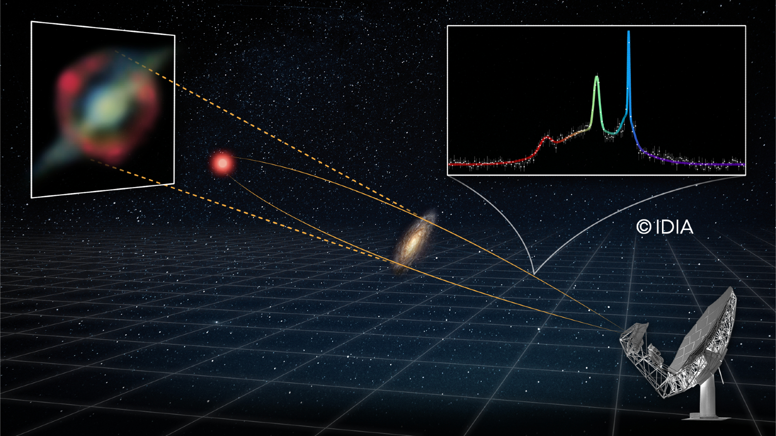


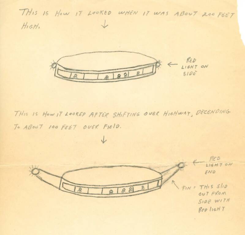


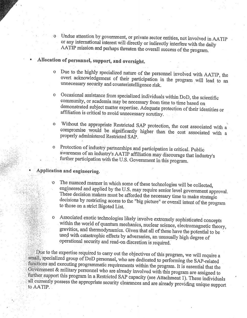
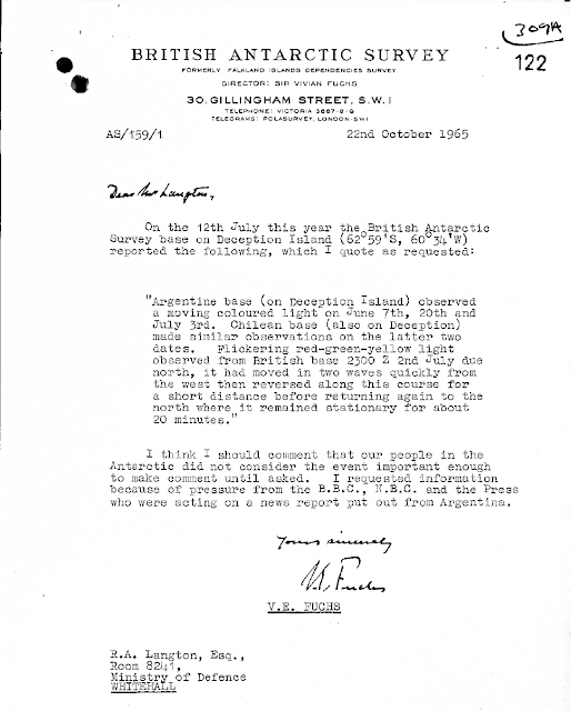


![Hacker claims Nasa has list of 'non-terrestrial officers' and UFO photos The Lone Hacker That Found NASA?s Secret Space Fleet [Gary McKinnon Interview]](https://metro.co.uk/wp-content/uploads/2026/03/SEI_287644860-edf2.jpg?quality=90&strip=all&w=646)
![Hacker claims Nasa has list of 'non-terrestrial officers' and UFO photos The Lone Hacker That Found NASA?s Secret Space Fleet [Gary McKinnon Interview]](https://metro.co.uk/wp-content/uploads/2026/03/SEI_287644861-cbbf.jpg?quality=90&strip=all&w=646)
![Hacker claims Nasa has list of 'non-terrestrial officers' and UFO photos The Lone Hacker That Found NASA?s Secret Space Fleet [Gary McKinnon Interview]](https://metro.co.uk/wp-content/uploads/2026/03/SEI_287644859-554f.jpg?quality=90&strip=all&w=646)


