The purpose of this blog is the creation of an open, international, independent and free forum, where every UFO-researcher can publish the results of his/her research. The languagues, used for this blog, are Dutch, English and French.You can find the articles of a collegue by selecting his category. Each author stays resposable for the continue of his articles. As blogmaster I have the right to refuse an addition or an article, when it attacks other collegues or UFO-groupes.
Druk op onderstaande knop om te reageren in mijn forum
Zoeken in blog
Deze blog is opgedragen aan mijn overleden echtgenote Lucienne.
In 2012 verloor ze haar moedige strijd tegen kanker!
In 2011 startte ik deze blog, omdat ik niet mocht stoppen met mijn UFO-onderzoek.
BEDANKT!!!
Een interessant adres?
UFO'S of UAP'S, ASTRONOMIE, RUIMTEVAART, ARCHEOLOGIE, OUDHEIDKUNDE, SF-SNUFJES EN ANDERE ESOTERISCHE WETENSCHAPPEN - DE ALLERLAATSTE NIEUWTJES
UFO's of UAP'S in België en de rest van de wereld Ontdek de Fascinerende Wereld van UFO's en UAP's: Jouw Bron voor Onthullende Informatie!
Ben jij ook gefascineerd door het onbekende? Wil je meer weten over UFO's en UAP's, niet alleen in België, maar over de hele wereld? Dan ben je op de juiste plek!
België: Het Kloppend Hart van UFO-onderzoek
In België is BUFON (Belgisch UFO-Netwerk) dé autoriteit op het gebied van UFO-onderzoek. Voor betrouwbare en objectieve informatie over deze intrigerende fenomenen, bezoek je zeker onze Facebook-pagina en deze blog. Maar dat is nog niet alles! Ontdek ook het Belgisch UFO-meldpunt en Caelestia, twee organisaties die diepgaand onderzoek verrichten, al zijn ze soms kritisch of sceptisch.
Nederland: Een Schat aan Informatie
Voor onze Nederlandse buren is er de schitterende website www.ufowijzer.nl, beheerd door Paul Harmans. Deze site biedt een schat aan informatie en artikelen die je niet wilt missen!
Internationaal: MUFON - De Wereldwijde Autoriteit
Neem ook een kijkje bij MUFON (Mutual UFO Network Inc.), een gerenommeerde Amerikaanse UFO-vereniging met afdelingen in de VS en wereldwijd. MUFON is toegewijd aan de wetenschappelijke en analytische studie van het UFO-fenomeen, en hun maandelijkse tijdschrift, The MUFON UFO-Journal, is een must-read voor elke UFO-enthousiasteling. Bezoek hun website op www.mufon.com voor meer informatie.
Samenwerking en Toekomstvisie
Sinds 1 februari 2020 is Pieter niet alleen ex-president van BUFON, maar ook de voormalige nationale directeur van MUFON in Vlaanderen en Nederland. Dit creëert een sterke samenwerking met de Franse MUFON Reseau MUFON/EUROP, wat ons in staat stelt om nog meer waardevolle inzichten te delen.
Let op: Nepprofielen en Nieuwe Groeperingen
Pas op voor een nieuwe groepering die zich ook BUFON noemt, maar geen enkele connectie heeft met onze gevestigde organisatie. Hoewel zij de naam geregistreerd hebben, kunnen ze het rijke verleden en de expertise van onze groep niet evenaren. We wensen hen veel succes, maar we blijven de autoriteit in UFO-onderzoek!
Blijf Op De Hoogte!
Wil jij de laatste nieuwtjes over UFO's, ruimtevaart, archeologie, en meer? Volg ons dan en duik samen met ons in de fascinerende wereld van het onbekende! Sluit je aan bij de gemeenschap van nieuwsgierige geesten die net als jij verlangen naar antwoorden en avonturen in de sterren!
Heb je vragen of wil je meer weten? Aarzel dan niet om contact met ons op te nemen! Samen ontrafelen we het mysterie van de lucht en daarbuiten.
23-02-2026
Impact-formed glass provides evidence of cosmic collision in Brazil about 6 million years ago
Impact-formed glass provides evidence of cosmic collision in Brazil about 6 million years ago
Some examples of "geraisites," named after the state of Minas Gerais where they were found, in their different forms. Credit: Álvaro Penteado Crósta/IG-UNICAMP
For the first time in Brazil, researchers have identified a field of tektites. These are natural glasses formed by the high-energy impact of extraterrestrial bodies against Earth's surface. These structures, named geraisites in honor of the Brazilian state of Minas Gerais, where they were first discovered, constitute a new strewn field. This expands the incomplete record of impacts in South America.
The discovery was described in an article published in the journal Geology by a team led by Álvaro Penteado Crósta, a geologist and senior professor at the Institute of Geosciences at the State University of Campinas (IG-UNICAMP). Crósta collaborated with researchers from Brazil, Europe, the Middle East, and Australia.
Until now, only five large tektite fields had been recognized on the planet: in Australasia, Central Europe, the Ivory Coast, North America, and Belize. The Brazilian field now joins this select group.
Where geraisites are found in Brazil
The geraisites were initially located in three municipalities in northern Minas Gerais—Taiobeiras, Curral de Dentro, and São João do Paraíso—in a strip about 90 kilometers long. Since the article was submitted, new occurrences have been recorded in the Brazilian states of Bahia and, more recently, Piauí. According to Crósta, this expands the known area to more than 900 kilometers in length.
"This growth in the area of occurrence is entirely consistent with what is observed in other tektite fields around the world. The size of the field depends directly on the energy of the impact, among other factors," the researcher explains.
By July 2025, the authors had collected approximately 500 specimens, a number that has since grown to over 600 with the most recent findings. The fragments range in size from less than 1 gram to 85.4 grams and reach about 5 centimeters on the longest axis. Their shapes are typical of aerodynamic tektites: spherical, ellipsoidal, drop-shaped, discoid, dumbbell-shaped, or twisted.
Although they appear black and opaque at first, they become translucent under intense light and display a grayish-green color. This color is distinct from that of European moldavites, which have been used in jewelry since the Middle Ages due to their characteristic intense green color. Their dark surfaces are marked by many small cavities.
"These small cavities are traces of gas bubbles that escaped during the rapid cooling of the molten material as it traveled through the atmosphere, a process also observed in volcanic lava but especially characteristic of tektites," says Crósta.
Geochemical fingerprint of geraisites
Geochemical analyses show that geraisites have a high silica (SiO₂) content ranging from 70.3% to 73.7%. The combined content of sodium (Na₂O) and potassium (K₂O) oxides ranges from 5.86% to 8.01%, which is slightly higher than in other tektite fields. Small variations in trace elements, such as chromium (10–48 parts per million) and nickel (9–63 ppm), were identified, indicating that the original material was neither pure nor homogeneous. The presence of rare inclusions of lechatelierite, a form of glassy silica produced at extreme temperatures, further supports an impact origin.
"One of the decisive criteria for classifying the material as a tektite was its very low water content, as measured by infrared spectroscopy: between 71 and 107 ppm. For comparison, volcanic glasses, such as obsidian, usually contain from 700 ppm to 2% water, whereas tektites are notoriously much drier," Crósta points out.
Dating based on the ratio of argon isotopes (⁴⁰Ar/³⁹Ar) indicates that the event occurred approximately 6.3 million years ago, at the end of the Miocene epoch. Three groups of very similar ages were obtained (6.78 ± 0.02 Ma, 6.40 ± 0.02 Ma, and 6.33 ± 0.02 Ma), which is consistent with a single impact event.
"The age of 6.3 million years should be interpreted as a maximum age since some of the argon may have been inherited from the ancient rocks targeted by the impact," the researcher comments.
Hunt for the missing crater
To date, no associated crater has been identified. According to Crósta, this is not unusual; only three of the six large classical tektite fields have known craters. In the case of the largest field, located in Australasia, the crater is believed to be oceanic. In Brazil, isotopic geochemistry indicates that the molten material originated in Archean continental crust between 3.0 and 3.3 billion years old. This directs the search to the São Francisco craton, an ancient and geologically stable portion of the continental crust and one of the oldest regions of the South American continent.
"The isotopic signature indicates a very ancient continental, granitic source rock. This greatly reduces the universe of candidate areas," says Crósta. In the future, aerogeophysical methods such as magnetic and gravimetric surveys may reveal circular anomalies associated with a buried or eroded crater.
Modeling the impact and its scale
While it is not yet possible to accurately estimate the size of the impacting body, researchers consider it unlikely that it was small. The large amount of molten material and the wide area of dispersion indicate a significant impact event, albeit smaller than the event responsible for the Australasia field, which extends for thousands of kilometers.
The team is currently working on a mathematical model of impacts to estimate parameters such as the energy released, the velocity, the angle of entry, and the volume of molten rock. They are doing this as new data on the spatial distribution of geraisites becomes available. The discovery of the geraisites fills an important gap in the record of impacts in South America. Only about nine large impact structures are known there, and almost all of them are much older and located in Brazil. This discovery also reinforces the idea that tektites may be more common than previously thought, but often go unnoticed or are mistaken for ordinary glass.
To combat sensationalist interpretations of cosmic impacts, Crósta manages the @defesaplanetaria Instagram profile with undergraduate students. The profile is dedicated to scientific dissemination and differentiating real risks from irresponsible speculation about meteorites and asteroids. Impacts were frequent during the formation of the solar system when a large amount of debris was scattered and planetary orbits were undefined. Large bodies migrated from one position to another, projecting smaller bodies in various directions. However, today, with the system stabilized, impacts are incomparably less frequent.
"Understanding these processes is essential to separating science from speculation," the researcher concludes.
Publication details
Alvaro P. Crósta et al, Geraisite: The first tektite occurrence in Brazil, Geology (2025). DOI: 10.1130/g53805.1
NASA’s Perseverancerover can now determine its location on the Red Planet independently, using its own “brain” and cameras. This saved it from having to “call” Earth every time to find out where it was. Engineers at the Jet Propulsion Laboratory (JPL) have essentially created a local navigation system for it that operates in real time.
Perseverance Mars rover. Photo: NASA/JPL
Imagine you find yourself in the middle of a vast desert with no landmarks or maps, and you are only allowed one phone call per day to ask, “Where am I?” This is how JPL robotics expert Vandi Verma describes the many years of work done by rovers.
Blind navigation
This panorama, taken by Perseverance, consists of five stereo pairs of images from the navigation camera, which the rover matched with orbital images to pinpoint its location on February 2, 2026, using a technology called Mars Global Localization. NASA/JPL-Caltech
Until recently, Perseverance, which has been exploring Jezero Crater for five years, relied on a combination of data: it analyzed images from its own cameras, measured wheel slip in dust, and cross-referenced satellite photos sent from Earth. However, due to the enormous distance of approximately 225 million kilometers, the signal took too long to arrive, so it took an entire Martian day to correct the route. If the rover was unsure of its position, it would simply stop and wait for “permission” from Earth. Over time, navigation errors accumulated and could reach more than 35 meters.
Space Google Maps
To solve this problem, engineers led by Jeremy Nash and Vandy Verma developed the Mars Global Localization system. It’s a kind of “space Google Maps” for the Mars rover.
How does it work? Perseverance is now taking pictures of the surrounding area, and a built-in algorithm compares them with detailed maps obtained from orbital spacecraft such as the Mars Reconnaissance Orbiter in just two minutes. The system automatically finds common features in the landscape — rocks, craters, sand dunes — and determines the rover’s coordinates with an accuracy of 25 cm. Human intervention in this process is no longer necessary.
Breakthrough that has been decades in the making
Development of the technology began in 2023. Archival images from 264 rover stops were used to test the algorithm — the system never made a mistake. In early February 2024, the function was successfully applied in practice for the first time in real conditions on Mars.
“We have given the Mars rover a new ability. This has been an open problem in robotics for decades, and it is incredibly exciting to finally see it solved in space,” said Jeremy Nash.
This update came shortly after Perseverance learned to plan routes using generative artificial intelligence. The AI independently assesses the terrain for hazards — boulders, steep slopes — and plots a safe route.
The future of autonomous missions
Now that the rover knows its exact location online, it can move much faster and cover greater distances every day. As scientists note, it was uncertainty about coordinates, rather than the dangers of the landscape, that was the main limitation on its travels.
This technology opens up a new era in the exploration of the Solar System. According to Vandy Verma, this algorithm is universal: “It can be used by almost any other rover that moves quickly and far.” This means that future missions to Mars and other planets will be able to work more efficiently, spending their time on real scientific discoveries rather than waiting for instructions from Earth.
Astronomers working with the James Webb Space Telescope (JWST) have published a spectacular new image. It shows the galaxy NGC 5134.
Galaxy NGC 5134 (photo by James Webb). Source: ESA/Webb, NASA & CSA, A. Leroy
NGC 5134 is located 65 million light-years from Earth in the direction of the constellation Virgo. This is a gigantic figure by human standards — we see the galaxy as it was at the time of the extinction of the dinosaurs. But by cosmological standards, NGC 5134 is quite close to us. And thanks to this relative proximity, JWST was able to see many details of its spiral structure.
JWST conducts observations in the near and mid-infrared range. The main source of “near” infrared waves are stars and star clusters scattered throughout the spiral arms of the galaxy. As for “medium” waves, they are emitted by warm dust, which saturates the gas clouds filling the galaxy. Dust particles consist of complex organic molecules called polycyclic aromatic hydrocarbons. They form flat ring-shaped structures, very similar to honeycombs in beehives. On Earth, they are found in smoke from fires, car exhaust fumes, or, say, burnt toast.
By combining the data collected by JWST, astronomers were able to obtain a portrait of the life cycle of a galaxy. The gas clouds stretching along the spiral arms of NGC 5134 are sites of star formation. Each star that forms gradually depletes the available gas reserves. They are partially replenished in the process of the death of old stars. The largest stars, whose mass exceeds that of the Sun by more than eight times, do so in spectacular ways, as a result of catastrophic supernova explosions, ejecting their matter hundreds of light years away.
Stars similar to the Sun also return some of their material, although not as spectacularly. They become red giants, after which they shed their atmosphere into space, forming planetary nebulae. In the future, this ejected material may become part of a new generation of stars. The same fate awaits our Sun in the future.
Everyone knows that there are volcanoes on Mars. Everyone knows that there are glaciers on Mars. But now scientists suggest that, at least on some volcanoes on the red planet, glaciers may be hidden under a layer of ash.
Hecates Tholus. Source: Wikipedia
Prevalence of glaciers on Mars
When we think of ice on Mars, we usually mean the poles, where it can be seen with probes and even ground-based telescopes. But the poles are difficult to reach, and even more so because of restrictions on research there due to potential biological contamination. Scientists had long hoped to find water closer to the equator, which would make it more accessible to human explorers. There are parts of Mars’ mid-latitudes that look like glaciers covered with thick layers of dust and rocks.
So, do these formations really conceal large reserves of water near the place where humans may first set foot on the Red Planet? Perhaps, yes, according to a new article by M.A. de Pablo and his co-authors, recently published in the journal Icarus.
The key may be a small volcanic peninsula in Antarctica. Known as Deception Island, this volcano covered part of the surrounding huge glaciers with ash and dust from a series of eruptions in the 1960s and 1970s. The authors believe they have found a volcano with a similar history on Mars, known as Hecates Tholus.
Hecates Tholus. is an ancient shield volcano on Mars that shares many of the same features as the volcano on Deception Island. And since we know that there is ice beneath the debris in Antarctica, this could mean that similar features may be found beneath the debris around Hecates Tholus.
Evidence of a glacier near Hecates Tholus
There is some compelling evidence on Mars that suggests the presence of glacial ice, rather than just loose rock or even rock cemented together with a small amount of ice. First and foremost, there are the crevasses. Any researcher will tell you how absurdly dangerous these features are on Earth, but the key characteristic on Deception Island is their visibility from space, especially near the so-called “headwalls” of the glacier — steep, almost vertical cliffs at the upper end of the glacier.
Such features are visible from space on Hecates Tholus, and such clear, visible fractures would not be noticeable if there were simply rock beneath them. In particular, these fractures mean that the solid ice core is still moving beneath the surface of volcanic debris.
Another direct piece of evidence is the presence of bergschrunds. These are distinct, deep cracks that form at the top of a glacier. Technically, all bergschrunds are a type of crack, although they are significantly larger and are formed by a very specific process compared to ordinary cracks. This process consists of separating movable ice from frozen ice. Some examples of bergschrunds near Hecates Tholus reach lengths of 600 m and are clear evidence that, at least at a certain point in time, there was active ice movement.
The final proof is the bulldozer effect, or, more precisely, the presence of “push moraines” at the bottom of the valleys of both Deception Island and Hecates Tholus. When glaciers move, they act like bulldozers, pushing huge rocks in front of them and leaving hilly terrain behind. Similar formations, such as those seen on Deception Island, are again visible around the volcano, indicating that a glacier once actively existed in this area.
Overview and context of Hecates Tholus, Mars (left) and the terrestrial analog, Deception Island (right).
Credit: Icarus (2026).
DOI: 10.1016/j.icarus.2026.116966
How to find hidden glaciers?
So if these glaciers really exist, how have they managed to survive for millions of years without evaporating? The authors propose a two-stage process. Initially, when cracks formed, some of the water actually sublimated, but these holes were then covered with dust, protecting the newly exposed water from further sublimation. Ultimately, this led to the formation of shallow “troughs,” which we actually see on Mars instead of real cracks.
One obvious question for people who closely follow Mars exploration is: why didn’t SHARAD see anything there? If there is a subsurface glacier at the equator, then the ground-penetrating radar on the Mars Reconnaissance Orbiter would undoubtedly be able to detect a signal from it. The physics of SHARAD radar does not work well on the steep slopes of volcanoes, making it difficult to obtain a clear image of what lies beneath the dust and debris. In order to truly understand the situation better, we will need samples from the surface, both from robots and from humans.
Fraser talks about the restriction of exploration missions to the Martian South Pole.
Avoid contamination
If there really are huge glaciers on Mars hidden beneath the dome of Hecate, there may be many others hidden beneath other massive volcanoes. Article IX of the 1967 Outer Space Treaty requires that exploration of other bodies in the Solar System be conducted in such a way as to avoid “harmful contamination” of celestial bodies. Many interpreted this article as a requirement for researchers to avoid the Martian poles, where there is evidence of large amounts of water. If it turns out that there is water all over Mars, hidden under volcanic debris, does that mean that these areas are now also off-limits to researchers?
Only time will tell the answer to this question — we may never know if there is water around these volcanoes unless we send researchers there — everything we can do remotely is limited. There are some proposals for missions that could resolve this question, such as FlyRADAR, but we will have to wait for the final word on whether Martian volcanoes are covered by glaciers — and perhaps look at the deceptive volcano on our own planet in the meantime.
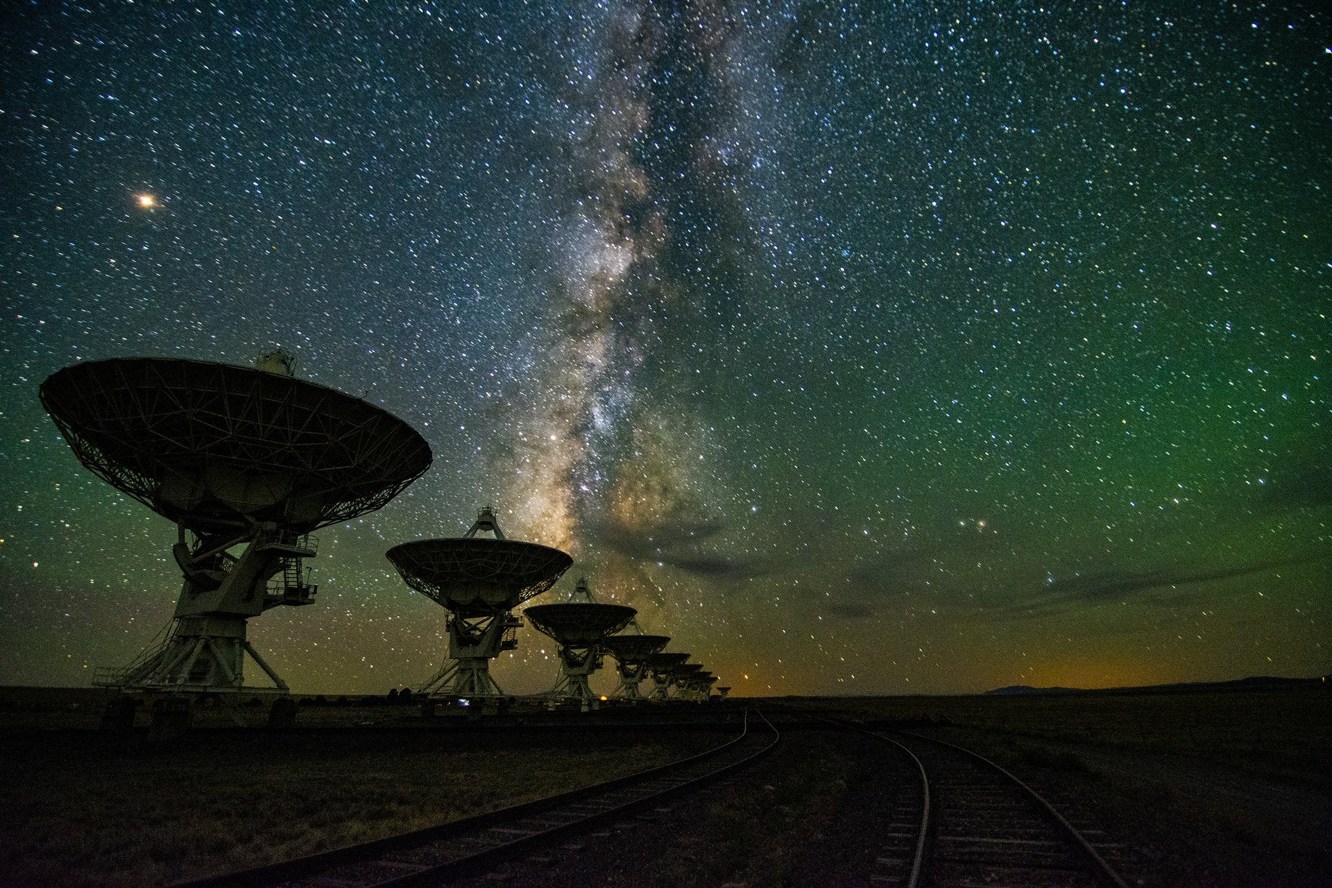
The Karl G. Jansky Very Large Array (VLA) in New Mexico at night. Credit: NRAO
More than sixty years ago, Dr. Frank Drake and his colleagues conducted the very first experiment dedicated to the Search for Extraterrestrial Intelligence (SETI). Since then, astronomers have continued to scan space for signs of alien transmissions, predominantly in the radio spectrum. In more recent years, the search has expanded to include thermal signatures and optical flashes, and additional forms of technological activity ("technosignatures") are already being incorporated. So far, all these experiments have produced null results, prompting SETI researchers to consider what they might be missing.
One possibility that repeatedly comes up is the notion that we are not looking in the right places. This certainly makes sense, since all SETI surveys to date have only covered a limited range of the radio spectrum. Following that logic, could it be that Earth has already received signals, but we didn't realize it because we weren't listening on the right frequency? According to a new study by Claudio Grimaldi, a researcher at the Laboratory of Statistical Biophysics at the Swiss Federal Technology Institute of Lausanne (EPFL), it's unlikely that we have.
The study, "Undetected Past Contacts with Technological Species: Implications for Technosignature Science," recently appeared in *The Astrophysical Journal*. Using Bayesian Analysis, a statistical technique that updates probabilities based on evolving data sets, Grimaldi examined how undetected past signals would have implications for current SETI surveys. In particular, he examined how past signals would increase the odds of detecting one today, and the likely source of those transmissions.
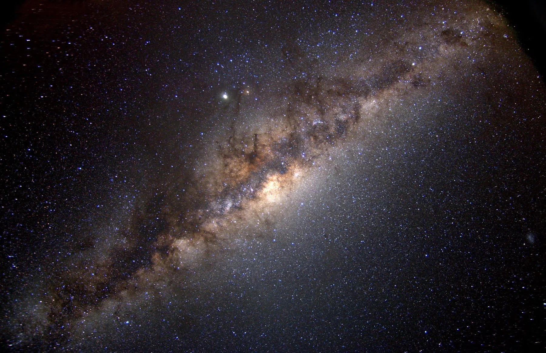
*The Milky Way galaxy, showing the central bulge at its center.
Credit: NASA*
As a starting point, he modeled technosignatures as active emissions or artifacts from an advanced civilization that then spread at the speed of light, lasting for brief periods (a matter of days) or for very long ones (millennia). He also considered how detection would only happen if the transmission is within range for the signal to be strong enough for our instruments to detect. He also considered omnidirectional signals (waste heat from megatructures) and highly focused signals (beacons, laser flashes, etc.). The resulting model addressed three possible elements:
The number of past contacts with Earth
The typical lifetime of technosignatures
The distance range that current or near-future instruments can probe
For "contact optimists," the results were not encouraging, suggesting that a very large number of undetected signals would have had to reach Earth in the past for there to be a high probability of detecting technosignatures closer to our Solar System today. In some cases, the number of signals exceeded the number of potentially habitable planets within a few hundred to a few thousands light-years from Earth, making any past or future signals highly unlikely. However, the results were different when extended to much greater distances.
Assuming technosignatures are long-lived and propagate across the entire Milky Way, detection becomes more likely at distances of several thousand light-years or more. However, the number of detectable signals across the entire galaxy at any given time remains very low. These results indicate that our inability to detect signals in the past does not mean detection will likely occur in the near future. Instead, they suggest that transmissions from advanced civilizations are likely to be rare, distant, and long-lasting, rather than local and frequent.
In other words, the field of SETI appears to be destined for a long wait before any discernible technosignatures (intentional or the result of "spillover") will be detected. Far from discouraging SETI efforts, however, the results suggest that future SETI efforts should focus on deeper, broader surveys that scan large parts of the Milky Way rather than individual stars or star clusters located a short distance away (in cosmic terms).
Not AGAIN! NASA's Artemis II moon mission is delayed for a second time after several last–minute issues are spotted on the SLS rocket – as furious fans call for SpaceX to step in
Not AGAIN! NASA's Artemis II moon mission is delayed for a second time after several last–minute issues are spotted on the SLS rocket – as furious fans call for SpaceX to step in
NASA's Artemis II moon mission has been delayed for a second time after several last–minute issues were spotted on the Space Launch System (SLS) rocket.
Mr Isaacman says that the reason for the delay is an 'interruption in helium flow in the SLS interim cryogenic propulsion stage'.
The system worked during both wet dress rehearsals, but engineers were unable to get helium flow through the vehicle during routine maintenance on Saturday night.
Now, as the long–awaited moon mission is pushed back once again, some frustrated fans have called for Elon Musk's SpaceX to step in with assistance.
Taking to X, one fan vented: 'Time to scrap the 1960s tech and innovate to build next gen space launch vehicles and to stay on par with SpaceX.'
NASA's Artemis II moon mission has been delayed for the second time, as last–minute technical issues are found in the Space Launch System (SLS) rocket
NASA administrator Jared Isaacman said that the issue had been caused by an 'interruption in helium flow in the SLS interim cryogenic propulsion stage'
Fed–up space enthusiasts have taken to social media to vent their irritation over the persistent delays.
One commenter wrote: 'At this rate, the Chinese will soundly beat us to the Moon.'
Others explicitly suggested that SpaceX should be called on to lend assistance or even replace the SLS rocket altogether.
On X, which is owned by SpaceX CEO Elon Musk, one commenter wrote: '@SpaceX Those guys need a ride to the moon, please help them.'
Another asked: 'When will NASA stop the financial haemorrhaging and turn this program over to SpaceX?'
'Can we get out of this contract and save money with SpaceX,' suggested another.
In particular, a number of space fans suggested that the experimental Starship rocket could make a viable replacement.
Mr Isaacman (left) says that the setback will 'almost assuredly' affect the intended March launch date, ruling out the Artemis II launch until April
Mr Isaacman says the systems performed well during both wet dress rehearsals, but unexpectedly failed during a 'routine operation'
On X, frustrated space fans have called for Elon Musk's SpaceX to provide assistance to the Artemis II programme
Why does NASA use hydrogen fuel?
The SLS rocket uses a mixture of liquid hydrogen and liquid oxygen.
Since hydrogen is such a small molecule, it is extremely prone to leaking.
However, hydrogen is also cheap, naturally abundant, and produces a phenomenal amount of energy.
According to NASA, this mix gives the 'highest specific impulse, or efficiency in relation to the amount of propellant consumed, of any known rocket propellant'.
Another important factor is that the SLS rocket inherits a lot of its hardware and systems from the Shuttle era rockets.
These engines were built to run on hydrogen, so NASA can't change fuels without an expensive redesign of the entire rocket and engine system.
'I beginning to think that the SpaceX Starship will be launching astronauts to space before the Artemis program,' one commenter suggested.
While one added: 'Time to replace SLS with Falcon Heavy. Might even actually do it faster with Starship.'
For context, SpaceX has been contracted by NASA to provide a modified version of Starship for the lunar landing during the Artemis III mission.
In April 2021, NASA awarded Elon Musk's company a $2.9 billion contract to provide the first crewed lunar lander, but SpaceX is widely expected to miss the 2027 target date.
Last year, acting NASA administrator Sean Duffy threatened to open up the contract to other countries due to persistent delays, saying at the time: 'The problem is, they're behind.'
However, NASA's immediate problems are the ongoing delays afflicting the problem–plagued SLS rocket.
Mr Isaacman says that the source of the problem could be located in one of the filers or quick–disconnect 'umbilicals' that pass gases between the ground and the rocket.
Alternatively, he says that the issue could have been caused by a 'failed check valve onboard the vehicle, which would be consistent with Artemis I'
Angry commenters lamented the costs of the SLS rocket and its persistent delays, arguing that the mission should be turned over to SpaceX
One commenter asked why America could 'get out of this contract' in order to save money with SpaceX
The SLS rocket will now need to roll back to the Vehicle Assembly Building at the Kennedy Launch Centre for repairs, meaning that another wet dress rehearsal is almost certain
After problems with the helium system were discovered overnight, NASA has now made the disappointing decision to roll SLS back to the Vehicle Assembly Building (VAB) at Kennedy Space Centre.
While the agency has a limited capacity to fix issues at the launch tower, more serious problems need to be addressed in the VAB, which gives engineers better access to the vehicle.
The vibrations caused by rolling the rocket in or out of the VAB risk loosening or disturbing seals and valves, meaning that one or two more wet dress rehearsals are almost certain.
After the success of the second wet dress rehearsal, the Artemis II crew entered quarantine in Houston, Texas, on Friday night.
During quarantine, the crew limit their exposure to other people so that they can stay in good health for the flight.
This procedure usually starts 14 days out from the launch date, but NASA has not said whether the crew will be able to leave quarantine before the April launch date.
Writing on X, Mr Isaacman added: 'I understand people are disappointed by this development. That disappointment is felt most by the team at NASA, who have been working tirelessly to prepare for this great endeavor.'
Launch date: NASA initially identified three possible launch windows for Artemis II: From February 6 to February 11, from March 6 to March 11, and from April 1 to April 6. The space agency is now targeting the April window.
Mission objective: To complete a lunar flyby, passing the 'dark side' of the moon and test systems for a future lunar landing.
Total distance to travel: 620,000 miles (one million km)
Mission duration:10 days
Estimated total cost: $44 billion (£32.5 billion)
- NASA Space Launch System rocket: $23.8 billion (£17.6 billion)
An exceptionally hungry black hole from the dawn of the universe is growing at 13 times the cosmic 'speed limit', experts say.
Astronomers have used high–tech telescopes to 'look back in time' to around 12 billion years ago, not long after the universe was born.
There, they spotted something unexpected – a supermassive black hole that already weighed 440 million solar masses.
This means it was growing at an unimaginably fast rate, they said, absorbing gas and dust quicker than it was believed possible.
According to theory, there should be a limit on how fast black holes can grow because the act of 'ingesting' matter creates an opposing force which prevents more matter from being absorbed.
But this cosmic giant, known as ID830, is defying expectations – and could mark the discovery of the fastest–growing supermassive black hole of a similar mass found to date.
Researchers suggest the black hole may have 'collided' with a star or clump of gas, giving it enough energy for this remarkable growth spurt.
'This discovery may bring us closer to understanding how supermassive black holes formed so quickly in the early universe,' lead author Sakiko Obuchi said.
A graph displaying ID830's uniquely brilliant luminosity, compared to previously observed objects. The solid line shows the upper 'limit' of how it should be growing
An artist's impression of a supermassive black hole. Gas accretes onto the central black hole, forming an accretion disk and jets
The team, from Waseda University and Tohoku University in Japan, used the Subaru Telescope to analyse the black hole.
What makes this one even more striking is its multiwavelength behaviour, the researchers, who published their findings in The Astrophysical Journal, said.
When black holes undergo growth spurts, most models predict that their structure changes in ways that can reduce X–ray emissions and that their plasma and radiation jets may be less obvious.
However, this particular black hole shines brightly in both X–rays and radio wavelength.
This unexpected combination suggests scientists still have more to learn about the mechanisms of early black hole growth, the team said.
'Going forward, we hope to explore the mechanisms of X–ray and radio wave emission from this quasar and determine whether there are any similar objects yet to be discovered,' Dr Obuchi said.
They suggest they may have observed the black hole during a short transitional period, possibly following a sudden influx of gas.
This could prompt both the X–ray–emitting corona and the radio jet to become highly energised before the system gradually settles into a more typical mode of growth.
In a press release from the universities, the researchers said: 'Data from the Subaru Telescope show a surprising mix of traits.
'The quasar is pulling in matter at an exceptionally high rate while also emitting intense X–rays and launching a strong radio jet.
Black holes are so dense and their gravitational pull is so strong that no form of radiation can escape them - not even light.
They act as intense sources of gravity which hoover up dust and gas around them. Their intense gravitational pull is thought to be what stars in galaxies orbit around.
How they are formed is still poorly understood. Astronomers believe they may form when a large cloud of gas up to 100,000 times bigger than the sun, collapses into a black hole.
Many of these black hole seeds then merge to form much larger supermassive black holes, which are found at the centre of every known massive galaxy.
Alternatively, a supermassive black hole seed could come from a giant star, about 100 times the sun's mass, that ultimately forms into a black hole after it runs out of fuel and collapses.
When these giant stars die, they also go 'supernova', a huge explosion that expels the matter from the outer layers of the star into deep space.
Onverwachte verschuiving van de magnetische noordpool
De magnetische noordpool van de aarde is aan het verschuiven. Hoewel dit eeuwenlang een geleidelijk proces is geweest, hebben recente waarnemingen een verandering in het tempo van de beweging aan het licht gebracht. Maar waarom gebeurt dit en wat zijn de gevolgen voor onze planeet?
Van de manier waarop onze smartphones werken tot de navigatie van vliegtuigen, de verschuivende magnetische noordpool heeft een verrassende invloed op ons dagelijks leven.
Geïntrigeerd? Klik door deze galerij om het zwervende magnetische veld van de aarde en de verrassende implicaties ervan te ontdekken.
Wat is het magnetische veld van de aarde? De aarde is een gigantische, bolvormige magneet. De aarde is omgeven door een magnetisch veld dat in de tijd en in de ruimte verschuift. Dit veld is afkomstig van verschillende bronnen binnen en buiten de aarde.
Als een staafmagneets Het lijkt erg op het veld dat wordt gecreëerd door een staafmagneet, maar dan geplaatst in het middelpunt van de aarde. Magnetische velden worden gecreëerd door bewegende elektrische ladingen. In een staafmagneet zijn deze ladingen elektronen die rondjes draaien in atomen.
William Gilbert Wetenschappers bestuderen het magnetisme van de aarde al eeuwenlang. William Gilbert, een 17e-eeuwse Engelse natuurkundige, was een pionier op dit gebied. Zijn experimenten en het gebruik van termen als 'elektrische kracht' en 'magnetische pool' legden de basis voor de moderne elektriciteit.
Reuzenmagneet Gilberts boek uit 1600, 'De Magnete', zorgde voor een revolutie in het begrip van magnetisme. Na uitgebreid onderzoek stelde hij voor dat de aarde zich gedraagt als een reusachtige staafmagneet, wat het gedrag van kompasnaalden en magnetische variaties gekoppeld aan geografische kenmerken verklaart.
Bevindingen Hij besprak het magnetisme van de aarde aan de hand van een model: een bolvormig stuk laststeen dat een terrella (kleine aarde) wordt genoemd. Magnetische naalden op een terrella wijzen naar de noordpool (aangeduid als punt A). Zelfs op een oneffen oppervlak, zoals bij punt O, wijzen de naalden nog steeds naar het noorden.
Vintage uitrusting In het begin van de 19e eeuw bestudeerden wetenschappers het magnetisme van de aarde met behulp van dipnaalden. Deze maten de hoek van het magnetische veld van de aarde op een willekeurig punt. Naalden staan horizontaal op de evenaar en verticaal op de polen. Wetenschappers gebruikten dompelnaalden op expedities vanaf de 18e eeuw.
Ontdekking De Schotse schout-bij-nacht Sir James Clark Ross ontdekte de Noordelijke Magnetische Pool in het noorden van Canada voor het eerst in 1831, na een aantal Arctische expedities.
Technische vooruitgang Een beter begrip van de magnetische polen van de aarde leidde tot vooruitgang in de navigatie. De 'True Course Finder', bijvoorbeeld, automatiseerde berekeningen voor zeelieden, waardoor ingewikkelde formules niet meer nodig waren. Vóór deze apparaten konden zeelieden alleen het magnetische noorden bepalen met een kompas, waardoor ze extra berekeningen nodig hadden voor het ware noorden.
In beweging Eeuwenlang hebben wetenschappers de magnetische noordpool gevolgd. In tegenstelling tot de stationaire geografische noordpool is de magnetische noordpool voortdurend in beweging. Tussen 1600 en 1900 bewoog hij ongeveer 10-15 kilometer per jaar.
Siberië-gebonden In de jaren 1990 dreef het naar de Atlantische Oceaan voordat het versnelde richting Siberië. Aan het begin van de jaren 2000 was de snelheid toegenomen tot ongeveer4 kilometer per jaar.
Siberië-gebonden In 2005 probeerden de Canadese geofysicus Larry Newitt en de Franse geoloog Jean-Jacques Orgeval het magnetische veld van de aarde vast te stellen tijdens een expeditie naar het Canadese noordpoolgebied. Ze bevestigden dat de dolende pool internationale wateren was binnengedrongen en op weg was naar Siberië.
Magnetisch Wereldmodel Het World Magnetic Model (WMM), gezamenlijk ontwikkeld door het Amerikaanse National Geophysical Data Center en de British Geological Survey (BGS), is een grootschalig model van het magnetisch veld van de aarde dat wordt gebruikt om de locatie van de pool te voorspellen. Het WMM wordt elke vijf jaar bijgewerkt en de nieuwste versie is nu beschikbaar.
Op de rem Terwijl de reis richting Rusland doorgaat, is de magnetische migratie van de Noordpool de afgelopen vijf jaar vertraagd tot ongeveer 35 kilometer per jaar. Deze snelheid van vertraging is volgens wetenschappers ongekend.
Canada vs. Rusland Een team onder leiding van professor Phil Livermore van de Universiteit van Leeds heeft een verklaring voorgesteld voor het recente gedrag van de magnetische Noordpool. Hij suggereert dat de pool gevangen zit in een touwtrekwedstrijd tussen twee concurrerende magnetische krachten, de ene onder Canada en de andere onder Siberië.
Canada vs. Rusland Livermore suggereert dat de Canadese magnetische patch uitgerekt en gesplitst is, waardoor de Siberische patch mogelijk sterker is geworden. Deze verschuiving in het evenwicht zou de verschuiving van de pool naar Rusland kunnen verklaren.
Wat veroorzaakt de beweging? De buitenkern van de aarde bestaat voornamelijk uit gesmolten ijzer, een vloeibaar metaal. Als warmte uit de kern ontsnapt, beweegt dit gesmolten ijzer en wordt het magnetische veld van de aarde opgewekt.
Ronddwarrelend Onvoorspelbare veranderingen in de wervelende beweging van dit gesmolten ijzer, dat zich ongeveer 3.218 kilometer onder het oppervlak bevindt, beïnvloeden het magnetische veld van de aarde en de positie van de magnetische pool.
Warme thee "Het is net een reusachtige kop thee," legt William Brown uit, een wereldwijde modelleur van het aardmagnetisch veld bij de British Geological Survey. "Het is een hete vloeistof met de substantie van water."
Implicaties voor de echte wereld De beweging van de noordelijke magnetische pool is cruciaal voor nauwkeurige navigatie. De gegevens die worden verzameld door de beweging te volgen, worden gebruikt om kompassen en andere navigatieapparaten te kalibreren.
Militaire navigatie Het leger vertrouwt ook op het World Magnetic Model voor nauwkeurige navigatie van onderzeeërs, vooral in moeilijke omgevingen zoals de Noordpool.
Luchthavens Landingsbanen van luchthavens zijn genummerd op basis van hun kompasrichting. Als het magnetisch veld van de aarde verschuift, moeten deze nummers worden bijgewerkt. De noordbaan van Berlin Brandenburg Airport veranderde bijvoorbeeld van 25R/07L naar 24R/06L in oktober 2024.
Constante bewaking Hoewel het onmogelijk is om exacte bewegingen te voorspellen, blijft de BGS het magnetische veld van de aarde in de gaten houden. Ze gebruiken een netwerk van grondstations en satellieten om het veld op verschillende locaties in kaart te brengen.
Pool flip? Wetenschappers weten dat het gesmolten ijzer in de kern van de aarde voortdurend wervelt en dat de magnetische polen altijd bewegen. Is het dan mogelijk dat er een volledige omkering plaatsvindt, waarbij het noorden het zuiden wordt en omgekeerd?
Magneetveld spiegelen De laatste volledige omkering vond 780.000 jaar geleden plaats. Een tijdelijke omkering vond 41.000 jaar geleden plaats, maar die duurde slechts 250 jaar voordat hij terugkeerde naar, de positie waar de polen zich vandaag de dag nog steeds bevinden.
Geen reden tot zorgen Hoewel omkeringen van de aardmagnetische polen alarmerend kunnen klinken, vinden ze over een lange periode plaats en vormen ze geen directe bedreiging voor het leven. Wetenschappers hebben bevestigd dat dergelijke gebeurtenissen geen significante kortetermijnveranderingen veroorzaken in het milieu van de aarde.
Scott Bray, former deputy director of Naval Intelligence, testifies during a House hearing on UAPs in 2022.
Photo: Kevin Dietsch/Getty Images
President Trump's decision to release government files related to aliens and UFOs is reigniting one of America's longest-running mysteries.
The big picture: While it's unclear whether any new significant surprises await, the belief that government secrets may prove extraterrestrial life exists has fueled curiosity and speculation for decades.
The latest chapter started when former President Obama said last week that aliens are real. He later clarified that he hadn't seen any evidence of aliens making contact with Earth.
But his remarks prompted Trump to suggest this was classified information and promise to release new records.
Here's what the government has previously shared:
What's confirmed by the government
Between the lines: Much of what's been confirmed has been about unidentified anomalous phenomena (UAPs) rather than "UFOs." UAPs are airborne objects that are not immediately identifiable.
The Office of the Director of National Intelligence (ODNI) confirmed in a 2021 report that UAPs are real, but there's no confirmation they stem from some extraterrestrial origin.
The Pentagon has largely maintained that there is no evidence of alien technology nor any hidden programs within the government related to UAPs.
UFOs have been on Congress' radar for years, mostly due to bipartisan concerns about transparency and national security.
Congress held a seriesof hearings from 2022 to 2024 as part of an investigation into UAPs and national security.
Several officials testified that UAP sightings have simple explanations — that they were actually balloons, drones and optical effects.
Officials also confirmed that hundreds of UAP reports exist, including military cases.
What they said:Sean Kirkpatrick, director of AARO, testified in April 2023 that many sightings involved "metallic orbs" — though he did not confirm extraterrestrial technology.
Whistleblower David Grusch testified in July 2023 that he believed the government was withholding evidence and information about UAPs.
A video of unidentified aerial phenomena plays during a House Intelligence subcommittee hearing in 2022. Photo: Kevin Dietsch/Getty Images
NASA, Pentagon downplay sightings
Flashback: In 2023, NASA released a report from its UAP study team that found no evidence of aliens.
However, the government agency said they aren't sure what UAP technically are and that more research could be done into defining the unidentified objects.
An unclassified 2024 Pentagon reportgave the public insight into what we know and don't know about UFOs.
The report mainly found that several of the sightings in the 1950s and '60s were likely caused by tests of advanced U.S. spy planes and other tech.
The report said there was no evidence of confirmed extraterrestrial activity related to UAPs.
Reported UFO sightings per 100k residents
Jan. 1, 1995, to Feb. 19, 2026; Approximate locations of 140,406 sightings submitted to the National UFO Reporting Center
A U.S. state map of reported UFO sightings per 100,000 residents from 1995 to 2026, as of February 19, 2026. About 140,000 sightings were reported in that time period, with the most sightings relative to population in Vermont (100 per 100,000 residents), Washington (95) and Montana (94).
Americans share reported sightingsall the time to the National UFO Reporting Center, which catalogs all reports for the public to read.
The most recent claim was on Feb. 10, when someone reported seeing a UAP in Cave Junction, Oregon, that was "a shooting star" that made "a zigzag pattern."
Of course, these reports are unconfirmed and anyone can file them.
By the numbers:The NUFORC collects data on where the most sightings have happened throughout the world.
California remains the state with the most reported sightings at 17,061 as of February 2026, per NUFORC.
The NUFORC reportsoffer varying details of what the unidentified objects look like.
More than 10,000 people described the UFOs as a "fireball," with 14,000 spotting a "triangle."
The bottom line: The truth is out there, and Trump's order could provide new evidence for believers and skeptics to seize on.
In the latest setback to return astronauts to the moon, NASA delayed the highly anticipated flight yet again after a new problem cropped up with the rocket Saturday.
April is now the earliest that the four Artemis II astronauts could fly to the moon.
NASA revealed the latest problem a day after targeting March 6 for Artemis II, the first manned flight to the moon in more than half a century. Overnight, the flow of helium to the rocket’s upper stage was interrupted, officials said. Solid helium flow is essential for purging the engines and pressurizing the fuel tanks.
This helium issue has nothing to do with the hydrogen fuel leaks that marred a countdown dress rehearsal of the Space Launch System rocket earlier this month and forced a repeat test.
NASA Administrator Jared Isaacman said a bad filter, valve or connection plate could be to blame for the stalled helium flow. Regardless of the cause, he noted, the only way to access the area and fix the problem is in the Vehicle Assembly Building at Kennedy Space Center.
“We will begin preparations for rollback, and this will take the March launch window out of consideration,” Isaacman said via X. NASA's next opportunities would be at the beginning or end of April.
“I understand people are disappointed by this development,” Isaacman said. “That disappointment is felt most by the team at NASA, who have been working tirelessly to prepare for this great endeavor.”
Earlier in the day, NASA said it was preparing to move the 322-foot rocket back to the Vehicle Assembly Building at Kennedy Space Center while raising the possibility of the work being done at the pad.
The situation is dynamic, said spokeswoman Cheryl Warner. Whether the fixes are at the pad or in the hangar, the rollback preparations alone rule out any chance of a March launch, she said.
Hydrogen fuel leaks had already delayed the Artemis II lunar fly-around by a month. A second fueling test on Thursday revealed hardly any leaks, giving managers the confidence to aim for a March liftoff. The four astronauts went into their two-week quarantine Friday night, mandatory for avoiding germs.
The interrupted helium flow is confined to the SLS rocket's interim cryogenic propulsion stage. This upper stage is essential for placing the Orion crew capsule into the proper high-altitude orbit around Earth for checkout, following liftoff. After that, it's supposed to separate from Orion and serve as a target for the astronauts inside the capsule, allowing them to practice docking techniques for future moon missions.
During NASA's Apollo program, 24 astronauts flew to the moon from 1968 through 1972. The Artemis program has completed only one flight so far, a lunar-orbiting mission without a crew in 2022. That first test flight was also plagued by hydrogen fuel leaks before blasting off, as well as a helium issue similar to the one that arose Saturday.
The upcoming mission will not involve landing on or orbiting the moon. The first lunar landing with a crew under Artemis is at least a few years away.
James Webb Space Telescope (JWST) data has allowed researchers to map Uranus’s upper atmosphere in three dimensions for the first time, showing how charged particles and temperatures vary with altitude.
JWST’s infrared NIRSpec instrument captured almost an entire 17-hour Uranus rotation, recording the planet’s glowing molecules floating above its clouds. The paper, published in Geophysical Research Letters, not only illuminates a part of our solar system but also provides new context for how energy is distributed on ice giants throughout the universe.
Uranus Through the James Webb Space Telescope
“This is the first time we’ve been able to see Uranus’s upper atmosphere in three dimensions,” said lead author Paola Tiranti of Northumbria University. “With Webb’s sensitivity, we can trace how energy moves upward through the planet’s atmosphere and even see the influence of its lopsided magnetic field.”
Data collected by JWST over a 15-hour period stretched up to 5000 kilometers above Uranus’s cloud layer. The team was focused on the ionosphere, the region where the atmosphere becomes ionized and interacts powerfully with the ice giant’s magnetic field. Their work is the most detailed understanding ever assembled of the planet’s upper atmosphere.
JWST Observes Temperatures on an Ice Giant
Activity across elevations observed in the new Webb data is not evenly distributed between temperature and ionization; temperatures peak between 3,000 and 4,000 kilometers, while ionization peaks at only 1,000 kilometers. The researchers say this is due to complexities in the ice giant’s magnetic field geometry.
Unlike Earth, where the magnetic field aligns with the planet’s rotation axis, on Uranus, the magnetic field is 60° off the center.
The NIRSpec results revealed temperatures and ion density in the ionosphere, along with new insights into the atmosphere’s cooling over the last three decades. The cooling trend confirmed in recent James Webb readings dates back to the 1990s, with a new low of 150°C compared to previous data collected by other platforms.
Magnetic Driven Auroras onUranus
Near the ice giant’s magnetic poles, NIRSpec detected two bright auroral bands. The data shows how Uranus’s tilted magnetic field shapes its auroras, increasing researchers’ understanding of the mechanisms behind these atmospheric light shows.
Intriguingly, JWST also detected a low-emission, low-ion region between the bands, similar to the dark regions observed on Jupiter. On both planets, researchers suspect that magnetic field lines are responsible for these bands, determining how charged particles travel through the upper atmosphere.
“Uranus’s magnetosphere is one of the strangest in the Solar System,” Tiranti explained. “It’s tilted and offset from the planet’s rotation axis, which means its auroras sweep across the surface in complex ways.”
“Webb has now shown us how deeply those effects reach into the atmosphere,” Tiranti added. “By revealing Uranus’s vertical structure in such detail, Webb is helping us understand the energy balance of the ice giants.
“This is a crucial step towards characterising giant planets beyond our Solar System,” Tiranti said.
Ryan Whalen covers science and technology for The Debrief. He holds an MA in History and a Master of Library and Information Science with a certificate in Data Science. He can be contacted at ryan@thedebrief.org, and follow him on Twitter @mdntwvlf.
Ook geen maanmissie in maart voor Artemis II, technische problemen gooien roet in eten
Ook geen maanmissie in maart voor Artemis II, technische problemen gooien roet in eten
Ook geen maanmissie in maart voor Artemis II, technische problemen gooien roet in eten
Maanmissie Artemis II zal zeker niet in maart plaatsvinden. Dat heeft NASA-baas Jared Isaacman zaterdag bekendgemaakt. Hij liet weten dat technische problemen met de SLS-raket de oorzaak zijn van het uitstel.
De problemen werden in de nacht van vrijdag op zaterdag door NASA-teams vastgesteld. Het gaat om een storing in de heliumtoevoer in een van de trappen van de raket, specificeerde Isaacman.
"Wat de mogelijke oorzaak van de storing ook is, deze problemen zullen het Amerikaanse ruimtevaartagentschap dwingen de raket terug te sturen naar de assemblagehal, waardoor de geplande lancering in maart niet doorgaat", legde hij uit op X.
Vrijdag nog had NASA aangekondigd dat het streefde naar een lancering op zijn vroegst 6 maart, na een grote test die succesvol leek te zijn verlopen.
Eerder waren er ook al technische problemen opgedoken waardoor de startdatum in februari moest uitgesteld worden.
Het huidige startvenster voor Artemis II loopt tot april. Met deze missie wil NASA voor het eerst sinds 1972 weer mensen richting de maan sturen. Later moeten ook bemande maanlandingen volgen.
De immense wit-oranje raket is bijna 100 meter lang. De bedoeling is dat de raket vier astronauten, drie Amerikanen en een Canadees, in een baan rond de maan zal brengen.
In het kader van de Artemis II-missie moeten de ruimtevaarders voorbereidende werken uitvoeren voor de volgende missie (Artemis III). Die staat gepland voor 2027. De bedoeling van Artemis III is om astronauten opnieuw op het maandoppervlak te doen landen, waar ze een permanente menselijke aanwezigheid moeten uitbouwen.
Antarctica's worst–case climate scenario laid bare: Terrifying study reveals how ice coverage could plummet by 20% by 2100 – sparking catastrophic global sea level rise
Antarctica's worst–case climate scenario laid bare: Terrifying study reveals how ice coverage could plummet by 20% by 2100 – sparking catastrophic global sea level rise
Antarctica's vast ice sheets and fragile ecosystems are already changing at an alarming rate – and now scientists have revealed just how bad it could get.
A terrifying new study has laid bare the frozen continent's best and worst–case climate change scenarios.
The international team of researchers focused their predictions on the Antarctic Peninsula, a region that is particularly sensitive to human–caused climate change.
In the worst scenario, sea ice coverage around the Peninsula could plummet by 20 per cent by 2100.
This would be devastating for polar species, such as penguins and whales, but could also cause disastrous consequences around the globe.
Like taking the ice cubes out of a cold drink, massive loss of sea ice will accelerate ocean warming, eroding the glaciers and ice shelves that threaten catastrophic sea level rise.
Lead author Professor Bevan Davies, of Newcastle University, says: 'Changes in the Antarctic do not stay in the Antarctic.
'Though Antarctica is far away, changes here will impact the rest of the world through changes in sea level, oceanic and atmospheric connections and circulation changes.'
These maps show the changes in sea ice coverage under a low (top), medium–high (middle), and very high (bottom) emissions scenario. The dark blue shows areas of more extreme ice loss
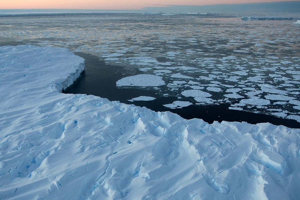
Scientists have laid bare Antarctica's worst–case climate scenario, as scientists predict that sea ice coverage could shrink by 20 per cent. Pictured: An area of the Antarctic Peninsula that had been covered by ice for thousands of years until 2024
Although the entire Antarctic continent is changing, the Antarctic Peninsula is in a unique position.
Unlike most of the continent, the Peninsula has been frequently visited by researchers, tourists, and fishers for much of the last century.
This means scientists have an extremely good picture of how the region has been affected by the warming climate.
Co–author Professor Peter Convey, of the British Antarctic Survey, says: 'For a casual visitor, the first impression is still inevitably that the region is ice–dominated.
'However, to those of us that have the privilege to go back multiple times, there are very clear changes over time.'
This area is also extremely important for ensuring that the global climate remains cool and stable.
The vast stretches of white ice reflect heat out into space and lock up fresh water that would otherwise increase sea levels and weaken vital ocean currents.
To understand how this sensitive region might continue to change in the future, the researchers used computer modelling to predict what would happen in low, medium–high, and very high emissions scenarios.
The researchers focused their predictions on the Antarctic Peninsula (pictured), a region that is particularly sensitive to human–caused climate change, to see how the area would change under different emissions scenarios
Antarctica's worst–case climate scenario
If emperatures rise by 4.4°C (7.92°F) by 2100:
- Ice coverage will plummet by 20%, sparking 22mm of sea level rise
- Krill will be decimated, limiting food for penguins, seals, and whale
- Heavy rain will wipe out the Adelie penguin population
In the low emissions scenario, global temperatures rise 1.8°C (3.24°F) above the pre–industrial average by 2100.
In the medium–high scenario, temperatures would increase by 3.6°C (6.48°F) by 2100, and the high emissions scenario will see the world get 4.4°C (7.92°F) hotter.
Co–author Professor Martin Siegert, of Exeter University, told the Daily Mail that the hottest scenario would be 'a world very different to today, in ways our human civilisation development has not previously coped with.'
In the worst–case scenario, water temperatures in the Southern Ocean will get hotter much faster.
According to the researchers' modelling, the Antarctic Peninsula alone could increase sea levels by up to 22 millimetres in 2100 and up to 172 millimetres in 2300.
Professor Davies told the Daily Mail: 'This would darken the ocean, making it better at absorbing heat, amplifying global warming.'
The Antarctic Peninsula has already undergone rapid changes due to global warming. In the 1990s, the exposed black peak emerging from the glacier in the top right was a tiny rock poking through the ice that was small enough to ski over
The loss of sea ice in the worst–case scenario will lead to widespread knock–on effects, including rapid ocean warming, the collapse of global ice shelves, rapid sea level rise, and greater severity of extreme weather events
Likewise, warmer water means the oceans can store more energy, leading to more violent weather all around the globe.
Loss of sea ice this dramatic will also have a huge impact on the Antarctic ecosystem, especially on the population of krill, a small crustacean that thrives in the Peninsula.
However, krill are entirely dependent on sea ice, so their population shrinks along with the ice.
Scientists have found that species like the Adelie penguin, which are highly dependent on sea ice and krill, have started to be replaced by more adaptable species.
'Adelie penguin chicks cannot tolerate rain as their downy feathers are not waterproof, so if they get wet, they get hypothermia,' Professor Davies explains.
However, the loss of krill also has serious consequences for humans because they are one of the major means by which the southern ocean absorbs and traps carbon dioxide.
Scientists have found that species like the Adelie penguin (pictured), which rely on sea ice and the krill that live there, are already vanishing from parts of the Antarctic Peninsula
This means that a collapse of the Antarctic ecosystem could accelerate the already devastating process of global warming.
Currently, researchers estimate that the world is on track for a medium or medium–high emissions scenario.
In a medium scenario, carbon dioxide emissions flatline and then begin to fall from 2100, while the medium–high scenario is a world in which emissions double by 2100.
Professor Davies says that we are currently somewhere between these two cases, but that 'resurging nationalism and protectionism' threatens to push the world towards the medium–high case.
In a lower emissions scenario, the ongoing effects of climate change will continue to trigger ice loss and extreme weather, but the effects will be much more muted.
Sea ice will only be a little smaller than it is today, and the sea level rise contributions from the Antarctic Peninsula will be limited to a few millimetres.
However, the hotter the world gets, the more destructive and permanent the effects of climate change will become.
Professor Davies says: 'These changes would be irreversible on any human timescale. It would be very hard to regrow the glaciers and bring back the wildlife that makes Antarctica special. If we don’t make changes now, our great–grandchildren will have to live with the consequences.'
Global sea levels could rise as much as 1.2 metres (4 feet) by 2300 even if we meet the 2015 Paris climate goals, scientists have warned.
The long-term change will be driven by a thaw of ice from Greenland to Antarctica that is set to re-draw global coastlines.
Sea level rise threatens cities from Shanghai to London, to low-lying swathes of Florida or Bangladesh, and to entire nations such as the Maldives.
It is vital that we curb emissions as soon as possible to avoid an even greater rise, a German-led team of researchers said in a new report.
By 2300, the report projected that sea levels would gain by 0.7-1.2 metres, even if almost 200 nations fully meet goals under the 2015 Paris Agreement.
Targets set by the accords include cutting greenhouse gas emissions to net zero in the second half of this century.
Ocean levels will rise inexorably because heat-trapping industrial gases already emitted will linger in the atmosphere, melting more ice, it said.
In addition, water naturally expands as it warms above four degrees Celsius (39.2°F).
Every five years of delay beyond 2020 in peaking global emissions would mean an extra 8 inches (20 centimetres) of sea level rise by 2300.
'Sea level is often communicated as a really slow process that you can't do much about ... but the next 30 years really matter,' said lead author Dr Matthias Mengel, of the Potsdam Institute for Climate Impact Research, in Potsdam, Germany.
None of the nearly 200 governments to sign the Paris Accords are on track to meet its pledges.
NASAhas completed an investigation into the 2024 Starliner fiasco that stranded two astronauts in space for nine months.
The space agency labeled the incident a 'Type A' mishap, the most severe classification of mission failure, it revealed on Thursday. That puts the Starliner test flight in the same category as the Challenger and Columbia disasters, which claimed a total of 14 lives.
Sunita Williams and Butch Wilmore were launched to the International Space Station (ISS) in July 2024 for what was intended to be an eight-day stay. However, the capsule malfunctioned, making it unsafe for human travel and forcing NASA to return it to Earth, leaving the astronauts stranded on the ISS until March last year.
NASA administrator Jared Isaacman said: 'Mistakes occurred from the program's inception and continued throughout execution, including contract management, oversight posture, technical rigor and leadership decision making.
'Boeing built the spacecraft, and from the onset, NASA approved variances and agreed to fly it. As development progressed, design compromises and inadequate hardware qualification extended beyond NASA's complete understanding.'
The investigation found both technical and organizational issues that affected the mission’s safety and oversight.
Decisions and pressures before and during the flight contributed to a culture that sometimes prioritized schedule over caution.
After the mission, concerns about reputation delayed the formal declaration of a mishap, and the program initially conducted its own review.
The Starliner launched Sunita Williams and Butch Wilmore to the International Space Station in July 2024 for what was intended to be an eight-day stay
The capsule malfunctioned, making it unsafe for human travel and forcing NASA to return it to Earth, leaving the astronauts stranded on the ISS until March last year
Starliner, developed under NASA’s Commercial Crew Program since 2010 to ensure continuous American access to low Earth orbit, faced a series of technical setbacks before its first crewed mission.
Early test flights, including Orbital Flight Test (OFT) 1 in 2019 and OFT-2 in 2021 and 2022, suffered guidance errors, thruster failures and oxidizer valve malfunctions, with investigations often addressing only immediate causes rather than underlying issues.
The crewed test flight in June 2024 encountered multiple propulsion anomalies, thruster failures and a temporary loss of full control during docking operations.
The launch took place under the Biden Administration.
Despite these challenges, the astronauts remained safe aboard the ISS, Isaacman said.
Starliner returned autonomously to Earth in September 2024 without crew, and Wilmore and Williams were later brought home safely by SpaceX Crew-9.
The report noted that engineering variances are common across major aerospace programs, but NASA found that Starliner’s qualification deficiencies made it less reliable for crew survival.
The agency acknowledged that it managed the contract, accepted the spacecraft, launched the crew and made critical decisions from docking through post-mission operations, placing a significant portion of responsibility on itself.
The investigation identified both organizational and technical factors contributing to the mishap, though the precise causes of the service and crew module thruster anomalies remain under review.
The American space agency labeled the incident a 'Type A' mishap, the most severe classification of mission failure, and the same as the Challenger disaster
NASA’s limited oversight, according to Issacman's report, left the agency without full insight into spacecraft systems, while Boeing’s propulsion design operated beyond safety qualifications.
Additionally, NASA’s desire to maintain two competing crew transportation systems influenced risk and operational decisions throughout the mission.
Pre-launch, more than 30 scheduled attempts created schedule pressure and decision fatigue, and prior thruster risks were inadequately addressed.
On-orbit disagreements over crew return options led to unprofessional conduct, while advocacy for the Starliner program often overshadowed safety priorities, the report said.
Post-mission, despite a severe loss of control and costs far exceeding Type A thresholds, a mishap was not initially declared due to concern for program reputation, and the Commercial Crew Program first investigated itself.
The independent investigation concluded that these decisions were inconsistent with NASA’s safety culture.
The agency has now formally designated the flight a Type A mishap to ensure lessons are captured for future missions.
Officials emphasized that program advocacy had exceeded reasonable bounds, placing the mission, crew and America’s space program at risk, and pledged leadership accountability to prevent such a culture of mistrust from recurring.
A new 3D map of Uranus is shedding light on one of the solar system's most mysterious planets.
Using NASA's James Webb Space Telescope, scientists observed the ice giant for nearly a full rotation, revealing the inner workings of its upper atmosphere for the first time.
The team, led by Paola Tiranti from Northumbria University, mapped out the temperature and density of ions in the electrically–charged layer that sits 3,100 miles (5,000km) above the cloud tops.
This has provided the most detailed picture yet of where the planet's stunning auroras form, releasing energy that creates a signature glow.
Their observations detected two bright auroral bands near Uranus's magnetic poles, which are lopsided and tilted by nearly 60 degrees.
As a result, its auroras sweep across the surface in complex patterns.
'This is the first time we've been able to see Uranus's upper atmosphere in three dimensions,' Ms Tiranti said.
'With Webb's sensitivity, we can trace how energy moves upward through the planet's atmosphere and even see the influence of its lopsided magnetic field.'
A collage showing Uranus's auroras captured during a full rotation. Observations detected two bright auroral bands near Uranus's magnetic poles, which are lopsided and tilted by nearly 60 degrees
The JWST data revealed two bright auroral bands near the magnetic poles and a zone of low emission and ion density between them.
According to researchers, this feature may be tied to the way Uranus's magnetic field directs charged particles, similar to observations made at Jupiter.
The measurements revealed that temperatures peak between 1,864 miles (3,000km) and 2,485 miles (4,000km) above the cloud tops, whilst ion densities reach their maximum around 621 miles (1,000km).
Analysis also confirmed that Uranus's upper atmosphere is still cooling, extending a trend that began in the early 1990s.
The team measured an average temperature of around 426 kelvins – about 150°C – lower than values recorded by ground–based telescopes or previous spacecraft observations.
Understanding why Uranus is cooling could provide crucial insights into how ice giant planets regulate their atmospheric temperature.
'By revealing Uranus's vertical structure in such detail, Webb is helping us understand the energy balance of the ice giants,' Ms Tiranti said.
'This is a crucial step towards characterising giant planets beyond our Solar System.'
The map has provided the most detailed picture yet of where the planet's stunning auroras form, releasing energy that creates a signature glow
More than one billion miles away from Earth, Uranus is one of the least explored planets in our solar system . So it comes as no surprise that scientists still regularly make new discoveries about the gas giant planet
At more than one billion miles away from Earth, Uranus is one of the least explored planets in our solar system.
Last year, scientists uncovered a secret moon hiding in its orbit, which is believed to be around six miles wide.
The discovery expands the total known number of moons orbiting Uranus to 29.
'No other planet has as many small inner moons as Uranus, and their complex inter–relationships with the rings hint at a chaotic history that blurs the boundary between a ring system and a system of moons,' said Matthew Tiscareno of the SETI Institute in Mountain View, California, a member of the research team.
The new findings, published in the Geophysical Research Letters, are part of an international collaboration that also involved the European Space Agency and the Canadian Space Agency.
A study analysing data collected more than 30 years ago by the Voyager 2 spacecraft has found that the Uranus's global magnetosphere is nothing like Earth’s, which is known to be aligned nearly with our planet’s spin axis.
A false-color view of Uranus captured by Hubble is pictured
According to the researchers from Georgia Institute of Technology, this alignment would give rise to behaviour that is vastly different from what’s seen around Earth.
Uranus lies and rotates on its side, leaving its magnetic field tilted 60 degrees from its axis.
As a result, the magnetic field ‘tumbles’ asymmetrically relative to the solar wind.
As a result, the magnetic field ‘tumbles’ asymmetrically relative to the solar wind.
When the magnetosphere is open, it allows solar wind to flow in.
But, when it closes off, it creates a shield against these particles.
The researchers suspect solar wind reconnection takes place upstream of Uranus’s magnetosphere at different latitudes, causing magnetic flux to close in various parts.
I just wanted to share this unique find I made back in 2020 so that my newer followers could see it too. It's something that should be impossible for nature to create, and yet it's there on the side of a crater on planet Mercury. The reason it was created by aliens could be that they use it as a wormhole manipulator, a method of harnessing wormholes to travel across the universe in a blink of an eye. Any technology that controls it, will be within its walls. All an alien needs to do is pass though it slowly with any ship. I'm confident there are many other portals too. I just wonder, can the end destination of the portal be adjusted to anywhere or is it limited to only other portal locations?
If you look up in the night sky and think the moon looks rather small, you're not wrong.
A new study has confirmed that the moon is shrinking.
Scientists from the National Air and Space Museum's Center for Earth and Planetary Studies have uncovered more than 1,000 previously unknown cracks on the lunar surface.
This shows the moon is contracting and reshaping itself, according to the experts.
Worryingly, the findings suggest that astronauts who may one day explore or live on the lunar surface may be at risk of devastating quakes.
'We are in a very exciting time for lunar science and exploration,' said Cole Nypaver, lead author of the study.
'Upcoming lunar exploration programs, such as Artemis, will provide a wealth of new information about our moon.
'A better understanding of lunar tectonics and seismic activity will directly benefit the safety and scientific success of those and future missions.'
Scientists from the National Air and Space Museum's Center for Earth and Planetary Studies have uncovered more than 1,000 previously unknown cracks on the lunar surface
Since 2010, scientists have known that the moon is gradually shrinking, as its interior cools and the surface contracts.
This shrinking has created distinctive landforms, known as 'lobate scarps', in the lunar highlands.
These structures form when the moon's crust compresses and the resulting forces push material up and over adjacent crust along a fault, creating a ridge.
However, in their new study, the researchers spotted strange cracks across a different area called the lunar maria – the vast, dark plains on the moon's surface.
They've named these cracks 'small mare ridges' (SMRs).
'Since the Apollo era, we've known about the prevalence of lobate scarps throughout the lunar highlands, but this is the first time scientists have documented the widespread prevalence of similar features throughout the lunar mare,' said Mr Nypaver.
'This work helps us gain a globally complete perspective on recent lunar tectonism on the moon, which will lead to a greater understanding of its interior and its thermal and seismic history, and the potential for future moonquakes.'
In the new study, the team discovered 1,114 SMRs, bringing the total found on the moon to 2,634.
Since 2010, scientists have known that the moon is gradually shrinking, as its interior cools and the surface contracts
On average, the SMRs date back around 124 million years, while the lobate scarps are around 105 million years old.
While this might sound old, it actually makes SMRs and lobate scarps some of the youngest geological features on the moon.
'Our detection of young, small ridges in the maria, and our discovery of their cause, completes a global picture of a dynamic, contracting moon,' said Tom Watters, who first discovered the cracks in 2010.
While the discovery of cracks helps to aid our understand of the moon's geological features, it could prove disastrous for space agencies who have probes on the moon – as well as those planning to send humans there.
Most notably, this includes NASA, which aims to land people on the lunar surface by 2028 as part of its Artemis III mission.
'The distribution of SMRs may also be of relevance to any long–term lunar habitation due to the hazards that shallow moonquakes pose to human–made lunar infrastructure,' the researchers cautioned in their study, published in The Planetary Science Journal.
For decades, scientists have been searching the skies for signs of extraterrestrial technology. A study by the University of Lausanne poses a pointed question: if signals from aliens have already reached Earth and we haven’t noticed them, what should we really expect to find today?
Why we still haven’t received signals from aliens. Source: phys.org
Searching for intangible technosignatures
Since the first SETI experiment in 1960, astronomers have been scanning the Milky Way for signs of advanced extraterrestrial civilizations. These searches have included radio waves, optical flashes, and infrared thermal signals. So far, nothing has been confirmed. This silence is often explained by the fact that we have only explored a tiny fraction of outer space. But what if signals did reach Earth and passed us by unnoticed?
A technosignature is any measurable signal or physical trace that indicates the existence of advanced technology beyond Earth, such as artificial radio transmissions, laser flashes, or excess heat from large-scale engineering projects.
For the technosignature to be detected, two conditions have to be met. First, the signal has to physically reach Earth. Secondly, our instruments should be sensitive enough, pointed in the right direction, and able to distinguish it from natural signals. This means that a signal may satisfy the first condition but still fail to meet the second. It may be too weak, too short, transmitted on an unsuitable wavelength, or lost in the noise.
It is often assumed that this may already have happened: extraterrestrial technosignatures could have reached Earth over the past six decades but remained undetected. If this is true, it means that even more signals may be passing us by right now, just waiting to be detected as our equipment improves.
SETI researchers investigated how detectable Earth is to alien civilizations, finding that our most visible technosignatures are radio emissions and atmospheric pollutants. If observed from nearby space, lasers, satellites, and city lights would also signal our presence. This study provides a new perspective on Earth’s visibility and helps refine SETI’s search strategies.
How many signals from aliens could have already reached Earth?
A new study challenges this assumption. Claudio Grimaldi, a theoretical physicist at the University of Lausanne’s Laboratory of Statistical Biophysics, has now investigated what unnoticed past contacts could mean for modern SETI searches. Using a statistical approach, Grimaldi asked the question: how many extraterrestrial signals would have had to cross Earth since 1960 for there to be a high probability of detecting one today, and from what distance from Earth would these signals most likely have come?
Grimaldi modeled techno-signatures as emissions from distant technological beings or their artifacts somewhere in the Milky Way. This radiation propagates at the speed of light and, according to this model, can last from very short periods, such as days, to very long periods, spanning thousands of years.
The Earth is considered “contacted” if such a signal passes through our location in space. Detection only occurs when the source is within range, where its signal is strong enough for our telescopes to pick up, reflecting both the signal and the sensitivity of the instruments.
Grimaldi used a Bayesian statistical approach, a method that updates estimates as new information becomes available, to combine three elements: the number of past contacts with Earth, the typical duration of technosignatures, and the range of distances that modern or future instruments can explore.
He considered both omnidirectional signals, such as heat radiation from large structures, and narrowly directed signals, such as beacons or laser flashes. The analysis treats these cases equally.
Research findings that challenge current views
The results of theoretical research cast doubt on the widespread optimistic view. If scientists today want to have a high probability of detecting technosignals at a distance of several hundred or even thousands of light years, this would require a very large number of technosignals to have passed Earth unnoticed in the past.
In many scenarios, this number becomes incredibly large, sometimes exceeding the number of potentially habitable planets in the region of the galaxy, making such scenarios highly improbable, but not strictly impossible.
This only changes when the search covers much greater distances. If technosignals are long-lived and widespread throughout the Milky Way, their detection becomes more plausible at distances of several thousand light-years or more. Even in this case, only a few detected signals can be expected across the entire galaxy at any given moment.
A change in approach to the search for extraterrestrial life
Research indicates that the fact that signals may have escaped detection in the past does not mean that their discovery is imminent. If extraterrestrial technologies exist and have contacted Earth, they are likely to be rare, distant, or long-lasting, rather than close and frequent.
This changes the perception of searching as a patient, long-term endeavor rather than a game of waiting for clear signals. This also strengthens the case for deep and wide surveys covering large parts of the Milky Way, rather than focusing solely on our cosmic neighborhood.
NASA's head of planetary defence has revealed what keeps her up at night – tens of thousands of 'city killer' asteroids that remain undetected.
Dr Kelly Fast, who leads efforts to find and track near–Earth objects like asteroids and comets, admitted they are still looking for around 15,000 mid–sized celestial bodies which could pose a threat.
While an impact from one of these – defined by being at least 140 metres wide – would likely not destroy the planet, they could 'really cause regional damage', she said.
And it turns out Earth still has no way to deflect one if we realised it was heading straight for us.
In 2022, NASA deliberately sent a spacecraft called Dart 6.8 million miles into space to crash into a mini moon called Dimorphos at 14,000mph in a bid to alter its orbit.
This mission was hailed as a success, paving the way for defending our planet by knocking incoming asteroids off their set path towards Earth.
But Dr Nancy Chabot, a planetary scientist at Johns Hopkins University who led that mission, said there are no other Dart–like spacecraft ready to launch if an asteroid was suddenly found to be on a collision course with Earth.
'Dart was a great demonstration,' she said. 'But we don't have [another] sitting around ready to go if there was a threat that we needed to use it for.'
2024 YR4 (pictured) was spotted in December 2024 and set alarm bells ringing as it reached the highest chances of hitting Earth of any known asteroid. Now, experts are concerned that it will hit the moon
An illustration of the main asteroid belt, orbiting the Sun between Mars and Jupiter, where thousands of asteroids can be found
She referenced YR4, an asteroid measuring up to 90 metres wide, which last year was deemed to have a 3.2 per cent chance of hitting Earth in 2032.
Eventually this chance was downgraded to zero, meaning no defensive action needed to be taken.
If something like YR4 had been headed towards the Earth, we would not have any way to go and deflect it actively right now,' she added.
'We could be prepared for this threat. And I don't see that investment being made.'
During the discussion, which took place at the American Association for the Advancement of Science (AAAS) conference in Phoenix, Dr Fast explained the biggest asteroids – which can measure over a kilometre in diameter – are much easier to detect and track.
However, it's believed that only 40 per cent of the mid–sized asteroids have been detected so far – meaning experts don't know where thousands of them are.
When asked what keeps her up at night, she replied: 'It's really the asteroids that we don't know about.
'We're not so much worried about the large ones from the movies, because we know where they are.
In 2022, NASA deliberately sent a spacecraft called Dart 6.8 million miles into space to crash into a mini moon called Dimorphos at 14,000mph in a bid to alter its orbit. Pictured: The asteroid as seen by the DART spacecraft 11 seconds before impact
Most asteroids can be found orbiting our Sun between Mars and Jupiter within the main asteroid belt
'And small stuff is hitting us all the time. Not so much worried about that.
'It's the ones in–between that could do regional damage. Maybe not global consequences, but they could really cause damage.
'And we don't know where they all are. It's not something that even with the best telescope in the world you could find.'
NASA has been tasked by US Congress with finding more than 90 per cent of near–Earth objects larger than 140 metres in diameter.
To achieve this, the agency is currently constructing a space telescope designed with the goal of detecting the majority of near–Earth asteroids and comets within a decade.
It is expected their near–Earth object (NEO) Surveyor mission will launch next year, with the capability of detecting both bright and dark asteroids, which are the most difficult to find.
'We're searching skies to find asteroids before they find us, and get them before they get us,' Dr Fast concluded.
POTENTIAL METHODS FOR ELIMINATING THE THREAT OF AN ASTEROID
DART is one of many concepts of how to negate the threat of an asteroid that have been suggested over the years.
Multiple bumps
Scientists in California have been firing projectiles at meteorites to simulate the best methods of altering the course of an asteroid so that it wouldn't hit Earth.
According to the results so far, an asteroid like Bennu that is rich in carbon could need several small bumps to charge its course.
'These results indicate multiple successive impacts may be required to deflect rather than disrupt asteroids, particularly carbonaceous asteroids,' researchers said.
Nuke
Another idea, known simply as 'nuke', involves blowing up a nuclear explosive close to the asteroid.
However, this could create smaller but still potentially dangerous fragments of rock that could spin off in all directions, potentially towards Earth.
Ion Beam Deflection
With Ion Beam Deflection, plumes from a space probe's thrusters would be directed towards the asteroid to gently push on its surface over a wide area.
A thruster firing in the opposite direction would be needed to keep the spacecraft at a constant distance from the asteroid.
Gravity tractor
And yet another concept, gravity tractor, would deflect the asteroid without physically contacting it, but instead by using only its gravitational field to transmit a required impulse.
Professor Colin Snodgrass, an astronomer at the University of Edinburgh said: 'There have been a few concepts suggested, such as a 'gravity tractor' to slowly tow an asteroid away instead of pushing it with a kinetic impactor.
'But the kinetic impactor is definitely the simplest technology to use on the sort of timescale that is most likely to be of concern for this size of asteroid, i.e. years to decades warning time.'
Antarctica is home to many mysteries, but one of the strangest is an enormous 'gravity hole' deep beneath the ice.
Gravity might feel stable and constant wherever we go, but its strength actually varies over the Earth's surface.
Antarctica has a gravity hole under its surface
Getty
Where the gravity is weaker, the ocean's surface can actually dip well below the average as water rushes towards regions with higher gravity.
Scientists have known for years that gravity is at its weakest in an area of Antarctica's Ross Sea, where sea levels dip 420 feet (130 m) below the surrounding water.
Now, a pair of researchers claim they finally know why.
The vast gravity hole, known as the Antarctic Geoid Low (AGL), is the product of incredibly slow rock movements, according to the experts.
Starting 70 million years ago – a time while dinosaurs still roamed the Earth – less–dense rock built up beneath the frozen continent and weakened the pull of gravity.
The gravity hole started small before rapidly growing in strength between 50 and 30 million years ago – creating the strange ocean dip that we see today.
Scientists have known for years that there is a mysterious 'gravity hole' in Antarctica where the sea level is 420 feet (130 m) below the surrounding water. Now, scientists think they know why
When astronauts on the International Space Station look down on Earth, it might look like a smooth blue marble.
However, in reality, our planet is shaped a bit more like a 'bumpy potato'.
This lumpy surface is due to areas of non–uniform gravity, caused by the uneven distribution of material beneath the surface.
In regions where hot rock from within the Earth's mantle rises towards the surface, the lower density of rock means that gravity is weaker.
Since the 1940s, scientists have known that these gravitational anomalies cause deep depressions across large areas of the ocean.
However, figuring out how and why these gravitational anomalies form hundreds of miles beneath the surface is much harder.
To map how the Antarctic gravity hole formed, the researchers combined earthquake recordings from around the world with a computer model of the planet.
Co–author Dr Alessandro Forte, of the University of Florida, says: 'Imagine doing a CT scan of the whole Earth, but we don't have X–rays like we do in a medical office. We have earthquakes.
Using a computer model, researchers found that the gravity hole was weak around 70 million years ago (left) but started to go stronger between 50 and 30 million years ago (right)
The strengthening of the gravity hole over under the Ross Sea coincided with the rapid advancement of Antarctica's ice sheets, including the Ross Ice Shelf (pictured). Researchers believe these events may be connected
'Earthquake waves provide the "light" that illuminates the interior of the planet.'
By looking at how earthquakes travelled through different densities of rock, Dr Forte and his co–author constructed a map of the planet's inner workings.
Using a computer model, they then worked out where the gravity would be stronger and weaker based on the different types of rock.
Once their predictions matched the best current data from gravity–sensing satellites, they wound back the clock and watched as the gravity hole formed over aeons.
They discovered that the gravity formed slowly at first, before gaining strength in a period known as the Eocene Epoch – beginning 50 million years ago.
Interestingly, this coincided with enormous changes in Antarctica's climate, including the rapid advance of the continent's ice sheets.
Although it is not yet proven, the researchers suspect that there could be a connection between the formation of the gravity hole and the formation of Antarctica's glaciers.
Dr Forte says: 'If we can better understand how Earth's interior shapes gravity and sea levels, we gain insight into factors that may matter for the growth and stability of large ice sheets.'
Scientists have previously found other gravity holes, including the Indian Ocean geoid low (IOGL), which is one of the deepest geoids on Earth
In the future, the researchers want to hunt for a causal connection between the gravity hole and the ice sheets by creating new mathematical models of the climate.
Tectonic plates are composed of Earth's crust and the uppermost portion of the mantle.
Below is the asthenosphere: the warm, viscous conveyor belt of rock on which tectonic plates ride.
The Earth has fifteen tectonic plates (pictured) that together have moulded the shape of the landscape we see around us today
Earthquakes typically occur at the boundaries of tectonic plates, where one plate dips below another, thrusts another upward, or where plate edges scrape alongside each other.
Earthquakes rarely occur in the middle of plates, but they can happen when ancient faults or rifts far below the surface reactivate.
These areas are relatively weak compared to the surrounding plate, and can easily slip and cause an earthquake.
Beste bezoeker, Heb je zelf al ooit een vreemde waarneming gedaan, laat dit dan even weten via email aan Frederick Delaere opwww.ufomeldpunt.be. Deze onderzoekers behandelen jouw melding in volledige anonimiteit en met alle respect voor jouw privacy. Ze zijn kritisch, objectief maar open minded aangelegd en zullen jou steeds een verklaring geven voor jouw waarneming! DUS AARZEL NIET, ALS JE EEN ANTWOORD OP JOUW VRAGEN WENST, CONTACTEER FREDERICK. BIJ VOORBAAT DANK...
Druk op onderstaande knop om je bestand , jouw artikel naar mij te verzenden. INDIEN HET DE MOEITE WAARD IS, PLAATS IK HET OP DE BLOG ONDER DIVERSEN MET JOUW NAAM...
Druk op onderstaande knop om een berichtje achter te laten in mijn gastenboek
Alvast bedankt voor al jouw bezoekjes en jouw reacties. Nog een prettige dag verder!!!
Over mijzelf
Ik ben Pieter, en gebruik soms ook wel de schuilnaam Peter2011.
Ik ben een man en woon in Linter (België) en mijn beroep is Ik ben op rust..
Ik ben geboren op 18/10/1950 en ben nu dus 75 jaar jong.
Mijn hobby's zijn: Ufologie en andere esoterische onderwerpen.
Op deze blog vind je onder artikels, werk van mezelf. Mijn dank gaat ook naar André, Ingrid, Oliver, Paul, Vincent, Georges Filer en MUFON voor de bijdragen voor de verschillende categorieën...
Veel leesplezier en geef je mening over deze blog.