Ontdek de Fascinerende Wereld van UFO's en UAP's: Jouw Bron voor Onthullende Informatie!
Ben jij ook gefascineerd door het onbekende? Wil je meer weten over UFO's en UAP's, niet alleen in België, maar over de hele wereld? Dan ben je op de juiste plek!
België: Het Kloppend Hart van UFO-onderzoek
In België is BUFON (Belgisch UFO-Netwerk) dé autoriteit op het gebied van UFO-onderzoek. Voor betrouwbare en objectieve informatie over deze intrigerende fenomenen, bezoek je zeker onze Facebook-pagina en deze blog. Maar dat is nog niet alles! Ontdek ook het Belgisch UFO-meldpunt en Caelestia, twee organisaties die diepgaand onderzoek verrichten, al zijn ze soms kritisch of sceptisch.
Nederland: Een Schat aan Informatie
Voor onze Nederlandse buren is er de schitterende website www.ufowijzer.nl, beheerd door Paul Harmans. Deze site biedt een schat aan informatie en artikelen die je niet wilt missen!
Internationaal: MUFON - De Wereldwijde Autoriteit
Neem ook een kijkje bij MUFON (Mutual UFO Network Inc.), een gerenommeerde Amerikaanse UFO-vereniging met afdelingen in de VS en wereldwijd. MUFON is toegewijd aan de wetenschappelijke en analytische studie van het UFO-fenomeen, en hun maandelijkse tijdschrift, The MUFON UFO-Journal, is een must-read voor elke UFO-enthousiasteling. Bezoek hun website op www.mufon.com voor meer informatie.
Samenwerking en Toekomstvisie
Sinds 1 februari 2020 is Pieter niet alleen ex-president van BUFON, maar ook de voormalige nationale directeur van MUFON in Vlaanderen en Nederland. Dit creëert een sterke samenwerking met de Franse MUFON Reseau MUFON/EUROP, wat ons in staat stelt om nog meer waardevolle inzichten te delen.
Let op: Nepprofielen en Nieuwe Groeperingen
Pas op voor een nieuwe groepering die zich ook BUFON noemt, maar geen enkele connectie heeft met onze gevestigde organisatie. Hoewel zij de naam geregistreerd hebben, kunnen ze het rijke verleden en de expertise van onze groep niet evenaren. We wensen hen veel succes, maar we blijven de autoriteit in UFO-onderzoek!
Blijf Op De Hoogte!
Wil jij de laatste nieuwtjes over UFO's, ruimtevaart, archeologie, en meer? Volg ons dan en duik samen met ons in de fascinerende wereld van het onbekende! Sluit je aan bij de gemeenschap van nieuwsgierige geesten die net als jij verlangen naar antwoorden en avonturen in de sterren!
Heb je vragen of wil je meer weten? Aarzel dan niet om contact met ons op te nemen! Samen ontrafelen we het mysterie van de lucht en daarbuiten.
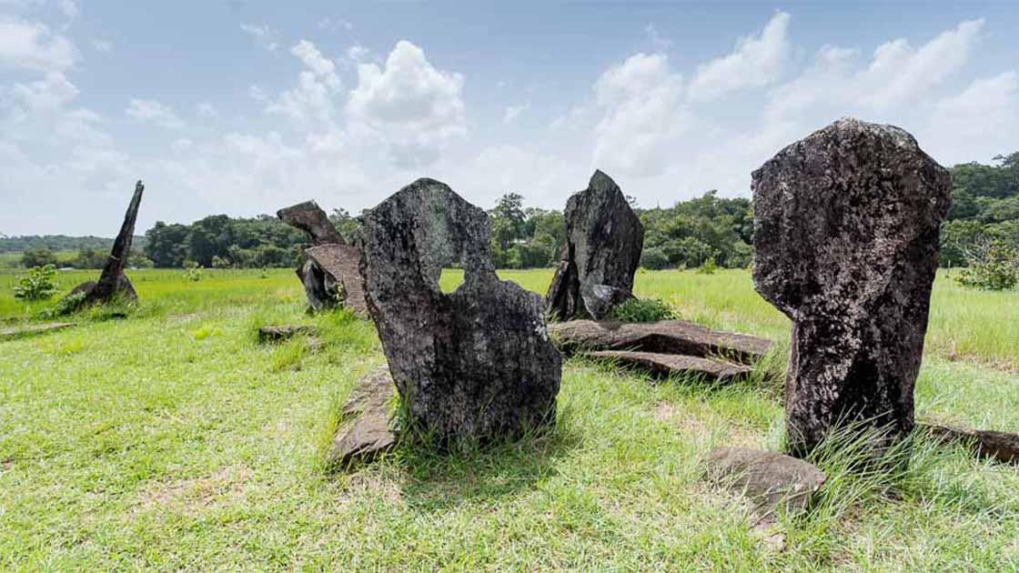
In the heart of Brazil's dense jungle, a remarkable discovery has emerged from the depths of history - a 'Stonehenge' hidden in the remote region of Calcoene. These mysterious megaliths, believed to be over a thousand years old, were unveiled, quite unexpectedly, on a cattle ranch exposed by deforestation. This astonishing revelation offers a fresh perspective on the ancient indigenous communities that once thrived within the Amazon rainforest. While the purpose of this stone arrangement is still the subject of speculation, scholars are leaning towards its use in astronomy.
Much like the famous Stonehenge in England, these massive stones could have served as an intricate celestial calendar , helping ancient Amazonians track celestial events such as solstices and equinoxes. The existence of this stone circle prompts us to reconsider the capabilities and knowledge of indigenous Amazonian peoples from centuries past. It challenges the misconception that their societies were devoid of advanced scientific understanding. As we piece together the puzzle of these megaliths, we gain deeper insights into the rich history and cultural achievements of the Amazon's original inhabitants.
Dinosaur Wall Mystery: How Did Dino Prints End Up On Bolivian Cliff Face?
Long before we left our mark with handprints on cavern walls, some unexpected artists left their traces on Bolivian rock faces. These mysterious imprints? None other than dinosaur tracks! A magical blend of events left us puzzling over these traces on a nearly vertical wall.
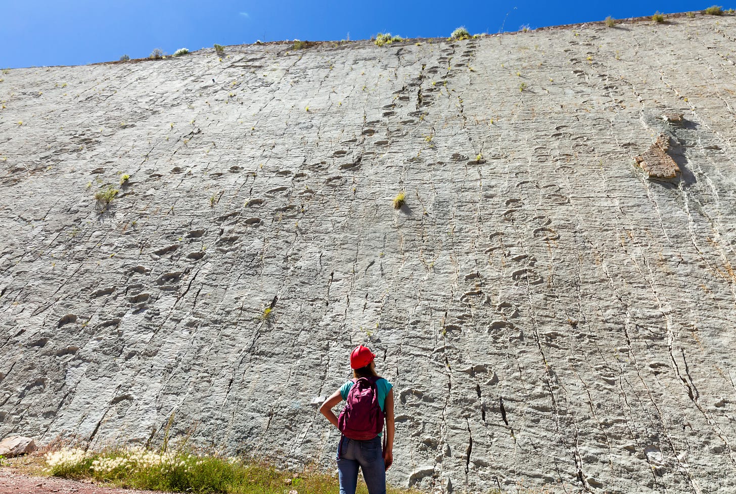
The dinosaur track wall at Bolivia’s Cretaceous Park.
Tucked away in Bolivia's Chuquisaca, near its capital Sucre, Cal Orcko boasts the Parque Cretácico (‘Cretaceous Park’), famed for a wall teeming with the world's densest collection of dinosaur tracks. Imagine the buzz of discovering not just one, but thousands of ancient footprints! Dubbed the ‘dinosaur dancefloor', this crisscross of trails helps researchers picture various dinosaur species that once ruled, played, and competed here.
Cal Orcko means ‘lime hill’ in the local Quechua language, and is an indication of the rock found at the site, i.e. limestone. This site is located within the territory of FANCESA, the national cement company of Bolivia. This cement company has been quarrying limestone for many decades, and it was the workers of this company who discovered the first dinosaur footprints at Cal Orcko in 1985. It was, however, only nine years later, in 1994, that the giant dinosaur track wall was exposed by mining activities.
Although palaeontologists had begun to investigate the dinosaur tracks, exposure to the elements and mining operations resulted in the erosion and crumbling of the wall. To protect it, it shut its doors for 8 years, finally reemerging as a tourist magnet in 2006.
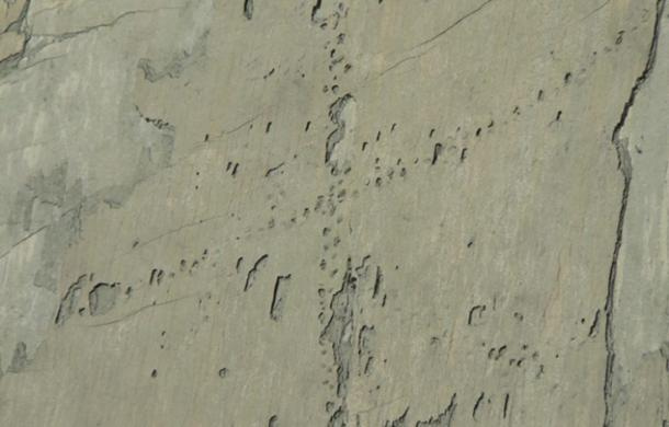
Undoubtedly, the park's crown jewel is the dinosaur track wall, stretching 80 m high and 1200 m long. It's a footprint treasure trove with over 5055 identified marks, branching into 462 unique trails, which showcase up to 15 different dinosaur species, all from the Cretaceous era. Hence, the park's moniker.
Footprints of some of the dinosaurs found at Cal Orcko. (Image: La gaveta )
Tracing the Footprints
It has been speculated that the Sucre area was once a large ocean inlet, and Cal Orcko a part of its shoreline. As dinosaurs walked along this shoreline during the Cretaceous period, they left their footprints in the soft clay, and were preserved when the clay solidified during the dry periods. A new layer of sediment would cover up the old one, and the process would begin again. As a result of this, multiple layers of dinosaur tracks were formed over time. This became evident in 2010, when a section of the wall collapsed. Whilst this destroyed some of the tracks, it also revealed another layer of footprints underneath it.
Dinosaur tracks and a disturbed section of the wall. ( CC BY 2.0 )
The Wall’s Rise to Fame
It has been hypothesized that the ocean inlet eventually became an isolated freshwater lake, based on the presence of freshwater creatures in the fossil evidence. Additionally, as a consequence of the shifting of the tectonic plates during the Tertiary period, the path that the dinosaurs once walked on rose upwards, and became an almost vertical wall. This is what led to today’s appearance of dinosaur tracks climbing the wall.
In the past, the cliff wall was fully accessible to the public, though in recent years, visitors could only get a glimpse of the wall from a viewing platform within the park. A new path has been unveiled, however, that allows visitors to get within a few meters of the wall, thus allowing much closer access to the dinosaur footprints.
The Wall’s Fragile Future
One of the main concerns regarding the dinosaur track wall is the fact that it is a limestone cliff. Pieces of rock, which may occasionally detach and fall from the cliff, can be considered to be a safety hazard. More alarming is the estimation that if the tracks are not adequately protected, it would be completely destroyed due to erosion in the near future. Therefore, the park is seeking to be recognized as a UNESCO World Heritage Site, which would provide it with the funds to carry out conservation work.
Top image: Fossilized dinosaur footprints at Cal Orko, Bolivia.
Atlantis Revealed: Plato's Cautionary Tale Was Based On A Real Setting
The time is 360 BC, the dawn of Western civilization. Athens, the cradle of democracy, is the epicenter of the ancient world. In his dialogues of Timaeus and Critias, Plato introduces a tale of an advanced prehistoric civilization, which since has captivated the imagination of every generation that followed. This was the story of Atlantis, an idyllic island paradise of skillful navigators who often crossed the Atlantic to explore. Atlantis, according to Plato, was ultimately lost to the sea. Its memory, though, was not soon forgotten.
For two millennia, people unsuccessfully kept on searching for the legendary island, making Atlantis one of the most lasting and fascinating stories of all time! What about those, however, who over time claim to have found the lost island? The truth is, no one until now was able to introduce a site that perfectly matched Plato's description. Instead, we have theories upon theories on the whereabouts of Atlantis. Why though? If everyone utilizes the same textbook, why the apparent confusion? Can this be a case of gross misinterpretation among researchers, or did early translators fail to properly capture and relay Plato's account? And, what about the chronological conflict that exists in Plato's account?
Let's take the original Santorini hypothesis, for example. Unquestionably, the island of Santorini, its volcanic eruption and the advanced Minoan civilization, was the best we had on Atlantis until recently. This was never a flawless hypothesis, though. Always a big problem with that theory was the fact that Plato's given chronology of 9600 BC had to be discarded (as Athens and most story details did not belong in that period). There is another bigger problem with that theory, though. While Santorini itself undeniably matches the site where the crown city of Atlantis once stood (talking about the concentric rings of earth and water) the problem is, Santorini alone never matched Plato's entire description. The primary island of Atlantis, one Plato said was to be 9 kilometers away, is missing from the particular setting of 1600 BC. These major flaws allowed for critics to raise doubts on that hypothesis, and to continue to question the validity of Plato's story.
Of course, serious research on Atlantis was never simple. Science fiction authors, movies and other creative works of popular culture, eventually capitalized on the story's popularity, and contrary to Plato's account, over time they turned Atlantis into an ultra-modern society with flying machines and technology far beyond our own.
Nonetheless, eventually every search comes to an end. Recently, a four year study that included a thorough analysis of Plato's work established that serious errors by early translators allowed for the mixed messages in the translated document.
The recent study not only decisively placed Atlantis in the Mediterranean Sea, but, it concluded with the discovery and identification of a submerged prehistoric island that in every way matches Plato's Atlantis. While in the past finding Atlantis was thought to be more difficult than winning the lottery, now there is a tangible site where all the physical characteristics of the given description match. The topography, the given chronology, the volcanic geology, the flora and fauna in that period, the island's destruction by a great flood, the presence of an unknown prehistoric civilization in the area, and DNA evidence all point to a genuine discovery.
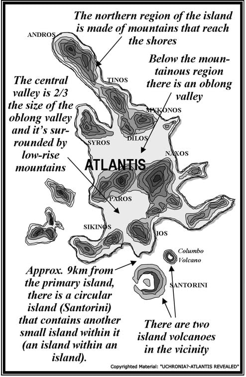
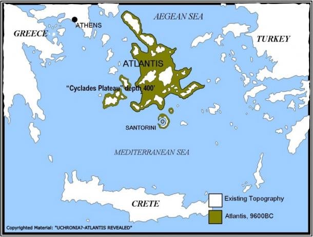
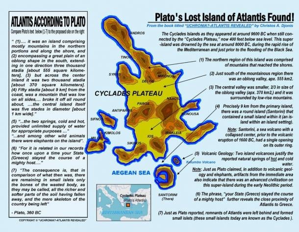
More specifically, the study shows that around 9600 BC, when according to Plato Atlantis was above water, the modern Cyclades Islands were connected by the Cyclades Plateau, a flat terrain (now 400 feet below sea level,) that formed the body of a huge island. When this prehistoric island is compared to Plato's Atlantis, it immediately becomes evident that this must have been the land Plato was talking about. Its northern region was comprised of mountains that reached the shores. Below the mountainous region there was an oblong valley measuring 555 Km 2. Below the oblong valley there was a smaller valley, 2/3 the size of the oblong valley that measured 370 Km 2. This was the primary island. Nine kilometers away from the primary island, and precisely as Plato depicted, lies the island of Santorini, a circular island with a flooded core and a small island in its center (Santorini, an island within an island setting, a sea volcano with a collapsed center, prior to the volcanic eruption of 1600 BC had a single opening on its outer ring that allowed ships to enter its watery caldera).
Plato's Atlantis
Atlantis area map
The consequence in finding Atlantis at around 9600 BC leaves no doubt that Plato based his story on a real setting and a prehistoric civilization known to ancient Greeks, which in order to successfully communicate some of his philosophical ideas (divine vs. human, ideal societies vs. corrupt,) he filled with familiar matter from later times, including details from the Minoan era of which he was more familiar with. The existence of a matching site at around 9600 BC, in essence, proves that Plato did exactly what Homer did with Troy 400 years before him. (Homer's Iliad was an entirely fictional story that revolved around a real setting and a historical incident that took place 600years before Homer himself.)
The super-island of the Cyclades Plateau (Plato's Atlantis) was drowned by the sea at around 8000 BC, during the rapid rise of the Mediterranean and just prior to the flooding of the Black Sea (see UNESCO study, 2009.) Incidentally, around this time, Lake Agassiz, a gigantic glacial lake in North America, also burst open and began to drain into the Atlantic. It is worth noting that Lake Agassiz covered an area larger than all the Great Lakes combined (440,000 Km 2) and at times, it contained more fresh water than all the lakes in the world today. The total fresh water outflow from this lake alone was so immense, scientists believe it raised the oceans worldwide by as much as nine feet and further produced the 8.2 kilo-year event that followed, a mini ice age that lasted 400 years! This global cataclysm at the end of the last Ice Age, which ultimately raised sea levels by 400 feet, not only erased our early history, but this could also be the event we all inadvertently refer to as the "Great Flood."
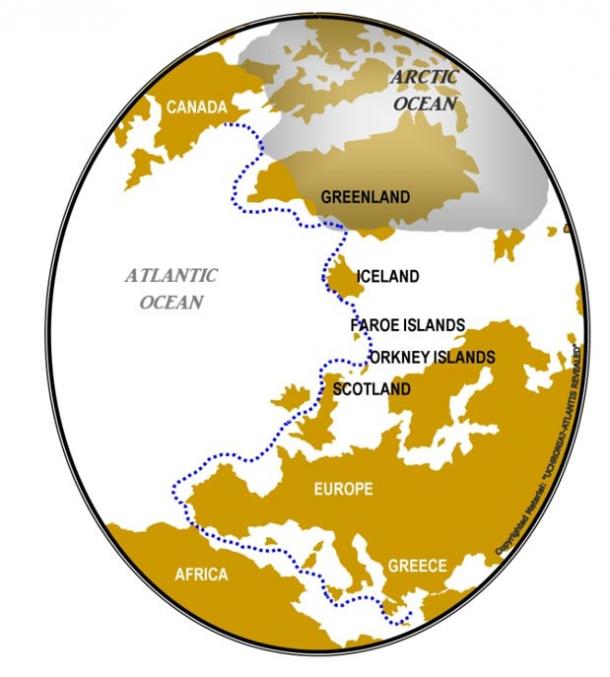
As for the island/continent across from the Pillars of Hercules, one larger than Libya and Asia combined, the latest study demonstrates how Plato's reference of the American continent got misconstrued into that of Atlantis. The mention of the continent across the Atlantic, "one that encompassed that veritable ocean," was Plato's poetic attempt to demonstrate Atlantis's incredible naval capability and its capacity to cross the ocean via island hopping (through Scotland, Orkney Islands, Faroe Islands, Iceland and Greenland.) Several clues and archeological evidence actually confirm that the ancient Greeks were aware of the American continent in order for Plato to include it in his story.
Crossing the Atlantic via island hopping
The implications of locating Atlantis in the Mediterranean go beyond the discovery itself. This find not only substantiates Plato's claim of prehistoric transatlantic crossings, but may finally help explain how the Mediterranean haplogroup X got to North America 10,000 to 12,000 years ago.
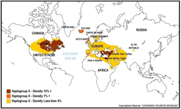
While most geneticists today maintain that haplogroup X walked to America via the Bering Strait, genetic maps show that the furthest region east of the Mediterranean with small traces of haplogroup X, is the Altai Republic in Southern Russia. No traces of haplogroup X exist between Altai Republic and the greater region of the Great Lakes. If haplogroup X infiltrated North America via the Bering Strait, why then does the greatest concentration of haplogroup X (away from the Mediterranean) exist around the Great Lakes and not in Alaska or alongside the west coast? Most importantly, how do we otherwise explain that heavy traces of haplogroup X incidentally also exist in Scotland, Orkney Islands, Faroe islands and Iceland, essentially all the island stops to North America from Europe.
Genetic Map of Haplogroup X
Finally, a 10,000 year old Mediterranean civilization, may help explain more archaeological oddities in this region. Recent erosion and seismic tests at the Giza Plateau, indicated that the Great Sphinx may be much older structure than previously thought, and along with the site of Gobekli Tepe in Turkey, both seem to coincide with Plato's story of Atlantis. Is it possible that Gobekli Tepe and the monument of The Great Sphinx could be remnants of the same advanced civilization Plato referenced in his story, one that was aggressively advancing against its neighbors in Africa and the Middle East, or do those belong to another culture? And what about the advanced proto-Euphratean people who descended upon the Mesopotamia around 7000 BC, from a region "unknown." Could these enigmatic people be the refugees of the same culture who fled the Mediterranean basin and moved eastwards to escape the inundation? Undoubtedly, they could have brought with them the story of the great flood as well as the skills and technology to incite yet another great civilization, like that of ancient Sumer (just as the survivors around the Cyclades and neighboring islands may have ultimately contributed to the rise of the Minoans).
Featured image: Artist’s representation of Atlantis. Source: BigStockPhoto
All other images are the Copyrighted Material of Christos A. Djonis and have been used with permission.
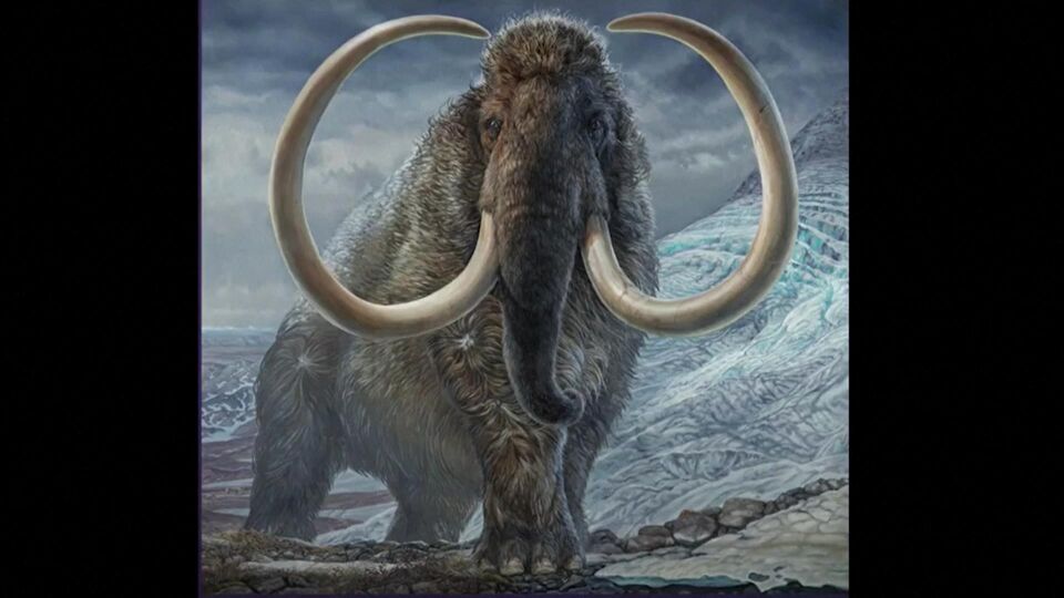
Aan de hand van DNA uit bodemstalen werden de vroegere fauna en flora uit het Yukon-gebied gereconstrueerd.
Julius Csotonyi
Oud DNA uit permafroststalen toont aan dat mammoeten en wilde Yukon-paarden duizenden jaren langer overleefd hebben dan gedacht
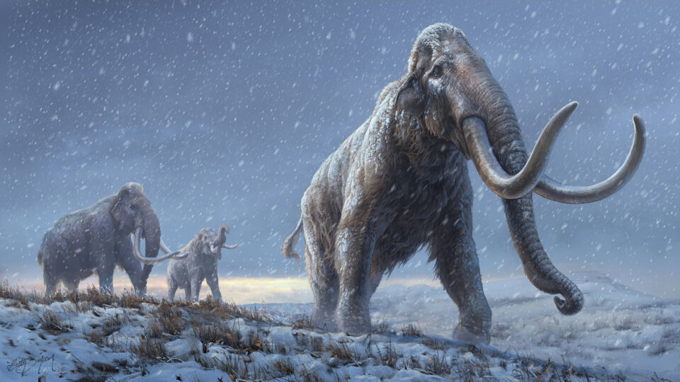
Enkele lepeltjes vol aarde uit de Canadese permafrost, meer hadden onderzoekers niet nodig om een nieuw, ruim venster te openen op het vroegere leven in het noordelijke Yukon-gebied. Dankzij gesofisticeerde analyses konden ze een DNA-databank aanleggen van de ecosystemen uit het verleden en meer informatie inwinnen over het overleven en uitsterven van megafauna als mammoeten, paarden en andere al lang uitgestorven levensvormen. Daar bleek uit dat mammoeten en wilde paarden langer overleefd hebben dan tot nog toe gedacht werd.
Luc De Roy
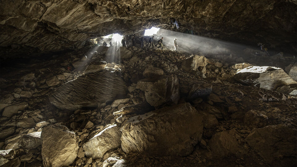
De sedimenten werden gehaald uit boorkernen van permafrost die afkomstig zijn uit het Klondike-gebied in het centrum van het Yukon Territory, het meest noordwestelijke deel van Canada dat grenst aan Alaska.
Onderzoekers van de Canadese McMaster University, de University of Alberta, het American Museum of Natural History en de regering van het Yukon Territory legden in hun nieuwe studie met DNA uit de sedimentstalen een DNA-bestand aan van de ecosystemen uit het verleden over een periode van 30.000 jaar.
Ze gebruikten daarvoor de 'DNA capture-enrichment' (DNA opvang en verrijking) technologie die ontwikkeld is aan de McMaster University. Daarmee konden ze in opmerkelijk detail de veranderende planten- en dierengemeenschappen reconstrueren op verschillende tijdstippen tijdens de overgang van het Pleistoceen naar het Holoceen. Dat was een periode met een onstabiel klimaat, zo'n 11.000 tot 14.000 jaar geleden, waarin een aantal grote soorten zoals mammoeten, mastodonten en sabeltandkatten verdwenen.
Ze reconstrueerden de oude ecosystemen aan de hand van minieme bodemstalen die miljarden genomische sequenties bevatten van dier- en plantensoorten.
Onderzoekers halen boorkernen permafrost uit de grond in het gebied in de buurt van Klondike.
Tyler Murchie
Tot 5000 jaar geleden nog mammoeten en Noord-Amerikaanse paarden
De analyse toonde aan dat mammoeten en paarden al een flinke achteruitgang kenden voor het klimaat onstabiel werd, maar ook dat ze niet onmiddellijk verdwenen ten gevolge van overbejaging door de mens, zoals eerder gedacht werd.
De aanwijzingen uit het DNA tonen integendeel aan dat zowel de wolharige mammoet als het Noord-Amerikaanse paard overleefde tot zelfs 5000 jaar geleden. Dat brengt hen bijna in het Laat-Holoceen, het geologische interval waarin we nu nog leven.
Gedurende het Vroeg-Holoceen bleef het milieu in het Yukon-gebied grote veranderingen ondergaan. Het ooit zo rijke grasland - de mammoetsteppe - werd overgroeid door struiken en mossen, soorten die niet langer in bedwang werden gehouden door grote grazende kuddes mammoeten, paarden en bizons.
Vandaag doen graslanden het niet al te best in het noorden van Noord-Amerika, voor een deel omdat er geen megafauna meer zijn die hen als 'ecologische ingenieurs' kunnen beheren.
"De overvloed aan gegevens biedt een unieke kijk op de populatiedynamiek van de megafauna en ze nuanceren de discussie over hun uitsterven dankzij subtielere reconstructies van de ecosystemen uit het verleden", zei evolutionair geneticus Hendrik Poinar, een hoofdauteur van de nieuwe studie en de directeur van het Ancient DNA Centre van McMaster.
De studie bouwt voort op eerder onderzoek van wetenschappers van McMaster die tot de conclusie waren gekomen dat wolharige mammoeten en Noord-Amerikaanse paarden waarschijnlijk nog aanwezig waren in het Yukon-gebied zo'n 9700 jaar geleden. Betere technieken en verder onderzoek hebben die eerdere analyse sindsdien verfijnd en de datum nog meer opgeschoven naar het heden.
Een video van de McMaster University met uitleg over de studie:
Enorme hoeveelheid gegevens in permafrost
"Nu we deze technologieën hebben, beseffen we hoeveel informatie over de geschiedenis van het leven er opgeslagen zit in permafrost", zei Tyler Murchie, een postdoctorale onderzoeker in het departement antropologie van McMaster en een tweede hoofdauteur van de studie.
"De hoeveelheid genetische gegevens in permafrost is echt enorm en laat de reconstructie van ecosystemen en de evolutie toe op een schaal die niet geëvenaard wordt met andere methoden", zo zei hij.
De onderzoekers benadrukten ook dat het nodig is om meer permafrost-stalen te nemen en te archiveren, aangezien die voor altijd dreigen verloren te gaan nu het Noordpoolgebied opwarmt.
"Hoewel mammoeten voor altijd verdwenen zijn, zijn paarden dat niet", zei mede-auteur Ross McPhee van het American Museum of Natural History. "De paarden die 5000 jaar geleden in de Yukon leefden, zijn directe verwanten van de paardensoort die we nu kennen, Equus caballus. Biologisch maakt dat van het paard een inheems Noord-Amerikaans zoogdier en het zou ook zo behandeld moeten worden."
In this recent interview with French researcher Jacques Vallée by Mystery Wire’s George Knapp, Vallée made the firm assertion that the “avocado-shaped" craft that crashed in San Antonio, New Mexico, in August 1945 (near the Trinity nuclear test site) was taken over (or would have been taken over) by Project Manhattan - that is the Atomic Energy Commission. He says that there exists a report from the Atomic Energy Commission about the object, which was apparently in possession of a then (female) State of Washington Governor who had shown it to someone who had been instrumental in getting her elected. The report is not in the Air Force files, it is not in the CIA files, it is not in anybody’s files, and one will never have permission to have access to that level of classification unless one is really inside the atomic secrets, even the President would not need to be told about it unless there was something that came up specifically on that topic where it would be the Secretary of Energy who will have authority. Last summer, Vallée published his new book Trinity: The Best-Kept Secret which he co-wrote with journalist Paola Harris. According to the book description and press release, Vallée analyzed a piece of debris that one of the witnesses claims to possess.
Kind regards.
André
MYSTERY WIRE - Jacques Vallée - Trinity UFO Crash in New Mexico
The atomic age officially began in August 1945 when the world’s first atomic bomb was detonated in New Mexico at a place called Trinity. But something else happened near that site just a few weeks later. A local rancher and his children said an egg-shaped craft of unknown origin crashed into the desert. The ranchers who lived near the bomb site saw and felt the blast.
DK/A/IRL/FIN/NOR 2015, RED 4K / DCP, Cinemascope (1:2,66), 90 Min.
Synopsis
A Documentary from Outer Space
THE VISIT is a documentary with comedy elements, and a philosophical exploration of our fear of strangers through the ultimate threat to our self-image: The discovery of Alien Intelligent Life.
In Vienna lies the UN-city, with its late 1970’s architecture and its extra-territorial status not unlike a giant spacecraft that has landed in the middle of the civilized world. Inside this impressive institution representing our belief in humanity, resides the UN Office of Outer Space Affairs – the OOSA.
THE VISIT opens with a close-up of an animal. It instinctively reacts to something unknown. Inside the OOSA, a phone rings. Deputy Director-General, astro-physicist, Dr. Mazlan Othman, is informed that an alien has arrived...
Meer van UFO'S of UAP'S, ASTRONOMIE, RUIMTEVAART, ARCHEOLOGIE, OUDHEIDKUNDE, SF-SNUFJES EN ANDERE ESOTERISCHE WETENSCHAPPEN - DE ALLERLAATSTE NIEUWTJES


 Deforestation Uncovers Ancient Megaliths in Brazilian Jungle (Video)