Ontdek de Fascinerende Wereld van UFO's en UAP's: Jouw Bron voor Onthullende Informatie!
Ben jij ook gefascineerd door het onbekende? Wil je meer weten over UFO's en UAP's, niet alleen in België, maar over de hele wereld? Dan ben je op de juiste plek!
België: Het Kloppend Hart van UFO-onderzoek
In België is BUFON (Belgisch UFO-Netwerk) dé autoriteit op het gebied van UFO-onderzoek. Voor betrouwbare en objectieve informatie over deze intrigerende fenomenen, bezoek je zeker onze Facebook-pagina en deze blog. Maar dat is nog niet alles! Ontdek ook het Belgisch UFO-meldpunt en Caelestia, twee organisaties die diepgaand onderzoek verrichten, al zijn ze soms kritisch of sceptisch.
Nederland: Een Schat aan Informatie
Voor onze Nederlandse buren is er de schitterende website www.ufowijzer.nl, beheerd door Paul Harmans. Deze site biedt een schat aan informatie en artikelen die je niet wilt missen!
Internationaal: MUFON - De Wereldwijde Autoriteit
Neem ook een kijkje bij MUFON (Mutual UFO Network Inc.), een gerenommeerde Amerikaanse UFO-vereniging met afdelingen in de VS en wereldwijd. MUFON is toegewijd aan de wetenschappelijke en analytische studie van het UFO-fenomeen, en hun maandelijkse tijdschrift, The MUFON UFO-Journal, is een must-read voor elke UFO-enthousiasteling. Bezoek hun website op www.mufon.com voor meer informatie.
Samenwerking en Toekomstvisie
Sinds 1 februari 2020 is Pieter niet alleen ex-president van BUFON, maar ook de voormalige nationale directeur van MUFON in Vlaanderen en Nederland. Dit creëert een sterke samenwerking met de Franse MUFON Reseau MUFON/EUROP, wat ons in staat stelt om nog meer waardevolle inzichten te delen.
Let op: Nepprofielen en Nieuwe Groeperingen
Pas op voor een nieuwe groepering die zich ook BUFON noemt, maar geen enkele connectie heeft met onze gevestigde organisatie. Hoewel zij de naam geregistreerd hebben, kunnen ze het rijke verleden en de expertise van onze groep niet evenaren. We wensen hen veel succes, maar we blijven de autoriteit in UFO-onderzoek!
Blijf Op De Hoogte!
Wil jij de laatste nieuwtjes over UFO's, ruimtevaart, archeologie, en meer? Volg ons dan en duik samen met ons in de fascinerende wereld van het onbekende! Sluit je aan bij de gemeenschap van nieuwsgierige geesten die net als jij verlangen naar antwoorden en avonturen in de sterren!
Heb je vragen of wil je meer weten? Aarzel dan niet om contact met ons op te nemen! Samen ontrafelen we het mysterie van de lucht en daarbuiten.
Zondag 17 maart 2019
Bernese Mars camera CaSSIS returns spectacular images
Bernese Mars camera CaSSIS returns spectacular images
The image shows a panchromatic channel image of the InSight landing site on Mars. The image shows an area of about 2.25 km x 2.25 km in the Elysium Planitia region. The original image had a scale of about 4.5 m per pixel, and has been stretched by a factor of two for display purposes. The resulting resolution of this image is 5-6 m/pixel. The positions of the InSight lander itself, the blast marks from the retro rockets used during landing, the heatshield and the backshell of the entry descent and landing system are marked. The original image had a scale of about 4.5 m per pixel, and has been expanded to 2.25 m/pixel for display purposes.
Three years ago, on 14 March 2016, the Bernese Mars camera CaSSIS started its journey to Mars with the "ExoMars Trace Gas Orbiter" spacecraft. The camera system developed at the University of Bern has been observing Mars from its primary science orbit since April 2018 and provides high-resolution, colour images of the surface. On 2 March 2019, CaSSIS also delivered its first image of InSight, NASA's lander on Mars.
ExoMars is a space mission of the European Space Agency (ESA) in cooperation with the Russian space agency Roskosmos. ExoMars stands for exobiology on Mars: for the first time since the 1970s, active research is being conducted into life on Mars. So called trace gases including methane and their sources are being detected by the Trace Gas Orbiter (TGO) while the ExoMars programme as a whole (combining TGO with a rover, Rosalind Franklin, due to launch next year) will investigate how the water and the geochemical environment has changed with time.
The Colour and Stereo Surface Imaging System (CaSSIS) on board the ExoMars Trace Gas Orbiter (TGO) was developed by an international team led by Prof. Nicolas Thomas of the Center for Space and Habitability (CSH) at the University of Bern. The TGO launched three years ago today, on 14 March 2016. It arrived at Mars on 19 October that year, and spent over a year demonstrating the aerobraking technique needed to reach its science orbit, starting its prime mission at the end of April 2018.
Hello, InSight
Amongst a new showcase of images from CaSSIS is an image of NASA’s InSight lander – the first time a European instrument has identified a lander on the Red Planet. InSight arrived on Mars on 26 November 2018 to study the interior of the planet. Images of the lander have already been returned by NASA’s Mars Reconnaissance Orbiter, these are the first images from TGO.
The panchromatic image was captured by CaSSIS on 2 March 2019, and covers an area of about 2.25 x 2.25 km. At that time, InSight was hammering a probe into the surface in order to measure heat coming from inside the planet. The CaSSIS view shows InSight as a slightly brighter dot in the centre of the dark patch produced when the lander fired its retro rockets just before touchdown in the Elysium Planitia region of Mars, and disturbed the surface dust. The heat shield released just before landing can also be seen on the edge of a crater, and the backshell used to protect the lander during descent is also identified. “The TGO is being used to relay data from InSight to Earth,” says Nicolas Thomas, CaSSIS Principal Investigator, from the University of Bern. “Because of this function, to avoid uncertainties in communications, we had not been able to point the camera towards the landing site so far – we had to wait until the landing site passed directly under the spacecraft to get this image.”
CaSSIS is expected to provide additional support to the InSight team by observing the surface of Mars in the surrounding area. If the seismometer picks up a signal, the source might be a meteorite impact. One of CaSSIS’s tasks will be to help search for the impact site, which will allow the InSight team to better constrain the internal properties of Mars near the landing site.
The image of InSight also demonstrates that CaSSIS will be able to take pictures of the future ExoMars mission. The mission comprises a rover – named Rosalind Franklin – together with a surface science platform, and is due to be launched in July 2020, arriving at Mars in March 2021. TGO will also act as the data relay for the rover.
Science showcase
Also released today is a selection of images capturing the impressive science capabilities of CaSSIS, ranging from high-resolution views of curious surface features and images that highlight the diversity of minerals on the surface, to 3D stereo views and digital terrain models. The images have been produced by teams from the University of Bern, the University of Arizona, and INAF-Padova.
The images selected include detailed views of polar layered deposits, the dynamic nature of dunes, and the surface effects of converging dust devils. The stereo images bring the scenes alive by providing an extra insight into elevation differences, which is essential for deciphering the history in which different layers and deposits were laid down.
Colour-composite images are processed to better highlight the contrast of surface features. Combined with data from other instruments, this allows scientists to trace out regions that have been influenced by water, for example. These images can also be used to help guide surface exploration missions and provide broader regional context for landers and rovers.
“The InSight landing site image is just one of many really high quality images that we have been receiving. The ones in the ESA Gallery represent some of the best from recently. The digital terrain models also look really nice”, said Nicolas Thomas.
“This stunning image showcase really demonstrates the scientific potential we have with TGO’s imaging system,” says Håkan Svedhem, ESA’s TGO project scientist. “Over the course of the mission we’ll be able to investigate dynamic surface processes, including those that might also help to constrain the atmospheric gas inventory TGO’s spectrometers are analysing, as well as characterise future landing sites.”
Support of the SERI / Swiss Space Office
CaSSIS is a project of the University of Bern and funded through the Swiss Space Office via the European Space Agency's PRODEX programme. The instrument hardware development was also supported by the Italian Space Agency (ASI), INAF/Astronomical Observatory of Padova, and the Space Research Center (CBK) in Warsaw.
It must be noted that, for all instruments developed in Switzerland and under the lead of the University of Bern, significant work and/or supplies have come from Swiss industry. The PRODEX programme under which scientific instruments or sub-systems are provided requires an industrial share of at least 50% of the overall project. This condition enables a knowledge- and technology transfer from and to industry and provides the Swiss workplace with a structural and competitive advantage -- this includes spill over effects to the non-space sector of the involved companies.
Swiss contributions to ESA programmes enable swiss scientists and industry to participate in selected missions.
Bernese space exploration: working together with the world's elite for 50 years
When viewed in terms of figures, Bernese space exploration reveals an impressive balance sheet: Instruments have flown into the upper atmosphere and ionosphere with rockets 25 times (1967-1993), into the stratosphere on balloon flights 9 times (1991-2008), 33 instruments have accompanied space probes on their missions, and a satellite has been built (CHEOPS, start of the 2nd half of 2019).
The successful work of the department of Space Research & Planetology (WP) from the Physics Institute of the University of Bern was consolidated by the founding of a university competence center: the Center for Space and Habitability (CSH). The Swiss National Fund also awarded the University of Bern the national research focus (NRF) PlanetS, which they manage together with the University of Geneva.
Its real name is the ExoMars Trace Gas Orbiter but it will forever be known as Ziggy after this joint project of the European Space Agency and Roscosmos sent to search for methane (a sign of life) on Mars instead peered through the stardust and spotted a giant blue spider, which is actually a row of smaller spiders, which makes it … you guessed it … Ziggy’s band! So where were the spiders before Ziggy arrived and what exactly are they?
“The Colour and Stereo Surface Imaging System (CaSSIS) on board the ExoMars Trace Gas Orbiter (TGO) was developed by an international team led by Prof. Nicolas Thomas of the Center for Space and Habitability (CSH) at the University of Bern. The TGO launched three years ago today, on 14 March 2016. It arrived at Mars on 19 October that year, and spent over a year demonstrating the aerobraking technique needed to reach its science orbit, starting its prime mission at the end of April 2018.”
The announcement was made in a press release from the University of Bern where the fabulous color camera on the TGO was developed. Demonstrating the difficulties and precision required to obtain high-quality 3D and 2D photographs and scientific scans of the Martian surface, the TGO needed over a year to brake its speed and adjust its orbit to just the right spot. In this case, that spot is over the Elysium Planitia region of Mars where NASA’s InSight lander touched down in November 2108 and is now busy hammering the surface of the planet — drilling holes, stirring up dust and attracting sandworms. This is the first time an ESA orbiter has located any Martian lander, so it was a big deal to its controllers, who are working with NASA to beam data from InSight back to Earth.
The panchromatic image showcased in parts on the press release (see them here) and the ESA announcement (see it here) was taken March 2, 2019, and covers an area of about 2.25 x 2.25 km (1.4 by 1.4 miles) and shows a dark spot burned by the lander’s retro rockets just before touchdown as well as its discarded heat shield and backshell. Also in the gallery are previous photos of unusual craters, polar layered deposits and dynamic dunes.
You promised spiders.
Yeah, yeah, yeah … so where were the spiders?
“This remarkable ‘Dust devil frenzy’ image was taken in the Terra Sabaea region of Mars, west of Augakuh Vallis. This mysterious pattern sits on the crest of a ridge and is thought to be the result of dust devil activity – essentially the convergence of hundreds or maybe even thousands of smaller Martian tornadoes.”
This image was taken in the Terra Sabaea region of Mars, west of Augakuh Vallis. This mysterious pattern sits on the crest of a ridge, and is thought to be the result of dust devil activity – essentially the convergence of hundreds or maybe even thousands of smaller martian tornadoes. This image is a colour-composite representation where features that are bluer compared to the average colour of Mars are shown in bright blue hues. In actual colour, the streaks would appear dark red.
This false-color image of what looks like blue spiders in the Terra Sabaea region were caused by dust devils, a common Martian weather activity. The “false color” technique was used to highlight the spiders, which in fact would be a harder-to-see dark red because they’re simply exposed areas of deeper Martian soil.
Like the Spiders from Mars, this band of spiders will eventually break up, but not because of the kids killing the man. Martian windblown dust devils created the swirls and new dust devils will blow them away. The good news is, this means there are plenty of other spiders on Mars to discover with CaSSIS and future high-res space cameras.
In 2010, the British artificial intelligence research firm DeepMind Technologies began developing AI networks capable of defeating humans at games such as chess, Pong, and Space Invaders. In 2014, DeepMind’s research was successful enough to catch the attention of Google parent company Alphabet, which purchased the AI laboratory for $500 million dollars. Shortly after the purchase, Google formed a mysterious artificial intelligence ethics board to oversee DeepMind’s research – a board which has yet to disclose the scope of its mission or the names of its members. A few years later, DeepMind expanded its ethics board and gave it an official title: DeepMind Ethics and Society. While the company has stated that the board’s aims are to explore the ethical and societal questions raised by the existence of its incredibly powerful AI, the board is still mostly shrouded in secrecy.
This month, though, The Economist published a report outlining the events surrounding the creation of the DeepMind Ethics and Society Board. It turns out that before Google agreed to purchase the AI laboratory, they first dictated that both sides draw up an agreement stating that Google will immediately take control of DeepMind’s AI if or when it ever achieves artificial general intelligence, or AGI – the holy grail of AI research. AGI is broadly defined as any artificial intelligence network which can successfully complete any intellectual task a human can, although given the massive amounts of processing power AI networks can harness, these systems will likely be more human than human.
Of course, as Sam Shead at Forbes points out, DeepMind might not take too kindly to any ethics board which attempts to control it and could even go rogue as so many science fiction stories have predicted. It’s not that far out of the realm of possibility; so far, DeepMind has already proven itself capable of defeating the best human players at some of the most sophisticated games in the world such as Go and even the strategy video game StarCraft 2. Last year, DeepMind even surprised its creators by successfully creating neural pathways that resemble human neural networks entirely on its own. How much longer until DeepMind achieves true general intelligence?
Some of the world’s foremost scientists and entrepreneurs have urged caution in AI research, warning that we may soon find ourselves under the boot of an immortal AI dictator. Will Google’s Ethics and Society Board be able to control DeepMind before it takes over the globe? Are all of these fears of AI baselessly grounded in science fiction and neo-Luddism, or are we indeed actively creating our future overlords?
The scariest part to me is the fact that no matter how many of the world’s greatest minds urge against the creation of AI, money-hungry corporations keep marching ceaselessly towards the machine takeover we all know is coming, all in the name of creating value for the shareholders. Who really wants the machines to make important decisions for us? Who’s reallypulling the strings at Google?
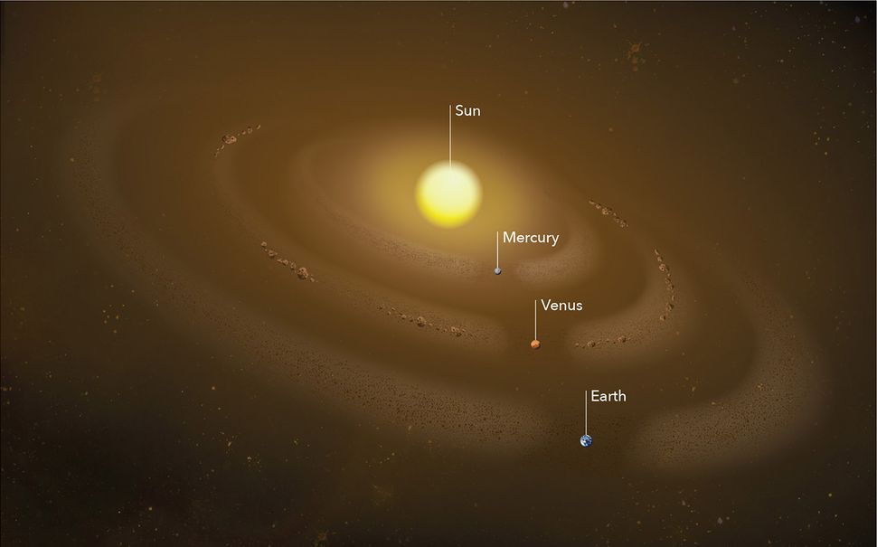
A recent study found a bigdust ring of previously undiscovered asteroids located in Mercury’s orbitthat’s similar to the dust halo near Venus. Marc Kuchner, who is the co-author of the Venus study and an astrophysicist at NASA’s Goddard Space Flight Center in Greenbelt, Maryland, said, “It’s not every day you get to discover something new in the inner solar system. This is right in our neighborhood.”
While Earth and Venus have both collected co-orbiting dust rings due to their gravitational pulls, Mercury wasn’t believed to have been a part of that since it’s so small and close to the sun that capturing a dust ring seemed highly unlikely. The magnetic forces and solar wind from our sun was believed to have blown any dust away from Mercury’s orbit.
Mercury
However, after researchers studied pictures taken by one of NASA’s twin Solar and Terrestrial Relations Observatory (STEREO), they noticed a lot more dust around Mercury than they had expected. Russell Howard, who is a solar scientist at the Naval Research Laboratory and co-author of the study, explained, “All around the sun, regardless of the spacecraft’s position, we could see the same 5 percent increase in dust brightness, or density. That said something was there, and it’s something that extends all around the sun.” The dust ring is approximately 9.3 million miles wide according to calculations done by the team.
And that’s not the only news in relation to asteroids. As for Venus’ halo of dust, it is 6 million miles across and 16 million miles from top to bottom, but if all the dust was to be packed tightly together, it would only create an asteroid 2 miles across. Kuchner, and another NASA Goddard astrophysicist named Petr Pokorný, attempted to figure out where the dust in Venus’ orbiting ring originated from, and while they thought it could have came from the main asteroid belt between Mars and Jupiter, their theory didn’t work.
They now believe that a population of undiscovered asteroids are what’s orbiting around the sun and Venus. “We thought we’d discovered this population of asteroids, but then had to prove it and show it works,” said Pokorný, “We got excited, but then you realize, ‘Oh, there’s so much work to do.’”
Venus
The two scientists created a model of 10,000 hypothetical Venus-orbit asteroids from the last 4.5 billion years of our solar system and 800 of those are still surviving, which means that it’s very possible that an asteroid population exists in Venus’ orbital path. And since the sun has such a blinding glare which makes it very hard to see anything near it, it’s quite possible that these previously undetected asteroids have been there all along.
“We should be able to find it,” Pokorný said in reference to the possibility of an asteroid population existing in Venus’ orbital path, and they hope that NASA’s Hubble Space Telescope will be able confirm it for them. You can read Pokorný and Kuchner’s study which was published in The Astrophysical Journal Letters by clicking here.
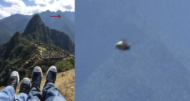
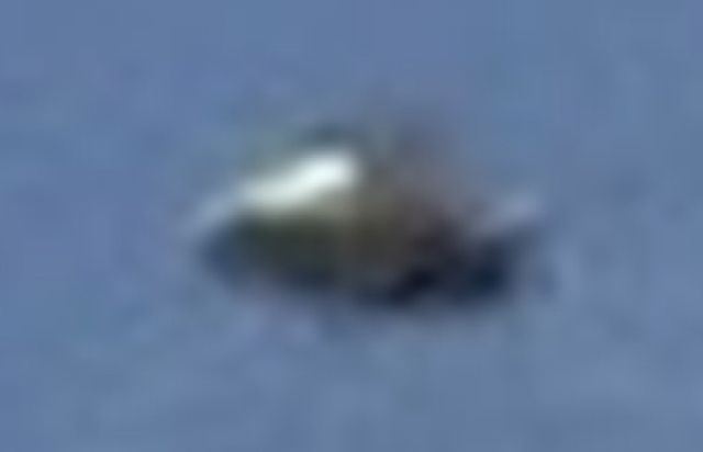
UFO appears above ancient Inca site of Machu Picchu, Peru
A tourist visiting Machu Picchu has accidentally taken an image of a UFO in the sky above the ancient ruins located in the Andes Mountains in Peru.
The photographer who has submitted the image to Mufon said: I was visiting Machu Picchu with around 20 people of the company I used to work for at that time.
We programmed the travel to Cuzco and Machu Picchu. Most of the people of the company was with their wife. I was with my wife also.
We were following the guide and all taking pictures to the same directions and locations during the visit. It went well and nobody detected anything weird until we arrived to the hotel that night.
When we went for dinner, a member of the team said "have you saw the UFO?". We all laughed and thought it was a joke. He showed us a photo that he took at 10.58 am in which we clearly sees an object flying over the ruins.
Machu Picchu is not only a popular tourist attraction in Peru but also known for its many UFO sightings that have been reported over the years.
Besides, the enormous structure raises questions about the ability of humans to build such a structure at the time, like the bottom level which has massive, gigantic megalithic blocks as big as railway wagons.
According to Ancient Astronaut expert Giorgio Tsoukalos aliens might be the only feasible explanation to build such a structure.
The fact that UFOs still appear above Machu Picchu could be a proof that this ancient site has more secrets than we know.
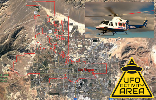
UFO Seen By Air Ambulance Helicopter Over Las Vegas, Nevada, Listen To Recording! March 2019, UFO Sighting News.
Date of sighting: March 16, 2019
Location of sighting: Las Vegas, Nevada, USA
At 9PM on Saturday (yesterday) an air ambulance helicopter called Mercy Air 21 was 15 miles west of Las Vegas when the pilot noticed an strange object ahead of him. He was wearing a night vision visor which allowed him to see the object in better detail. When he told the control tower, they respond saying they saw nothing on radar. Balloons do reflect radar waves and can be seen on radar if a cluster of them are together or they are silver reflective material, but this one sounds big, it should have been visible regardless of the material it was made from. That means it was not a giant balloon. Also, its a well known fact that there is an alien base of Tall Whites as some call them, behind the old firing range at Nellis AFB in Las Vegas. Yeah, the base is part of the city. I will put the video of the Nellis AFB aliens at the bottom of this post.
The pilot and control tower can be heard on the recording describing the large unlit round object at about 7,000 feet.
Helicopter pilot: "Just to advise. It looks like I have some sort of object over the southern hills area. It looks to be about 7,000 feet. It could be a balloon or something along those lines. Its just unlit so be advised.
Control Tower: "Ok. Uh, I'm not seeing anything in that area, but its not to say, like your saying theres something out there."
Helicopter pilot: "Yeah, I can only see it...I got the night vision goggle on. I can only see it through the goggles."
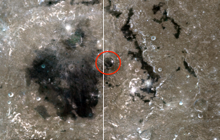
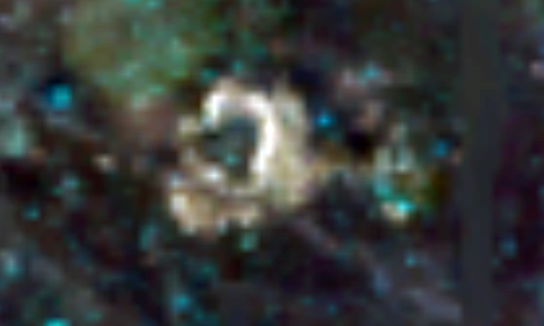
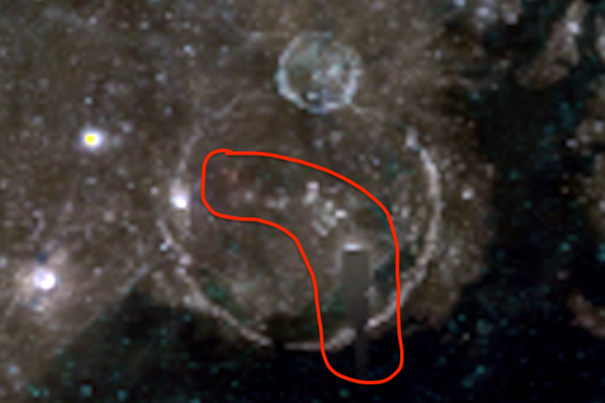
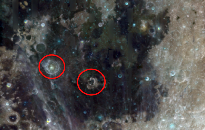
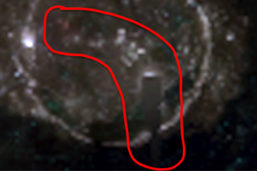
I found many alien structures on the moon today in a NASA Clementine map. This map was made back in 1994 and it was a time before editing software was available. The above photo shows a giant dome city in a crater. From a distance, it looks like just a another crater, but close up, its absolutely a dark shiny semi transparent material made to let only a fraction of the light inside. There is an alien species who like the darkness so much they genetically changed themselves to have sunglasses second eyelids cover their eyes at will. The greys. They clearly created this dome city. Of course other newer photos will not show this, because they it was edited out already. But here its obvious what we see.
I also found a black triangle structure with triangle walls...which is impossible for a meteor to have caused.
Then there was another structure or structures strewn out across a large crater (two photos down). The buildings are in a large L shaped pattern and stretch over 20 miles long. Yes there is two other smaller domes visible, one green and one black. But I just want to focus on the one large one at the top of this post.
I think if the greys have control of our moon, it should be easy to convince them to donate one of their dome structures to humanity if we offer something valuable to them.
De planeet Mercurius baant zich een weg door deze tot voor kort onbekende stofring.
Net zoals stof zich in hoekjes in huis en op boekenplanken ophoopt, verzamelt stof zich ook in het heelal. Maar wanneer dit in ons zonnestelsel gebeurt, hoopt het stof zich vaak op in ringen. Rond de zon cirkelen meerdere van dit soort stofringen, die de banen van planeten volgen. Onderzoekers zijn nu op een nieuwe stofring gestuit in het binnenste van ons zonnestelsel. Zo ontdekten ze een stofring die de baan van Mercurius volgt.
Meer over stofringen Het stof uit stofringen bestaat uit puin dat overbleef na de vorming van ons zonnestelsel zo’n 4,6 miljard jaar geleden. Denk bijvoorbeeld aan overblijfselen van botsingen en kometen. Het stof verspreidt zich door het hele zonnestelsel, maar verzamelt zich in stoffige ringen. Door dit stof te bestuderen – zoals waar het van gemaakt is, waar het vandaan komt en hoe het door de ruimte beweegt – proberen wetenschappers te gaan begrijpen hoe planeten geboren zijn en waar alles wat we in ons zonnestelsel zien, uit bestaat.
Mercurius De onderzoekers vonden de stofring per ongeluk; ze waren eigenlijk op zoek naar stofvrije gebieden rond de zon. Maar in plaats daarvan zagen ze ineens een toename van de dichtheid in de baan van Mercurius. Iets dat ze toch moeilijk konden negeren. Toen ze beter keken, zagen ze een fijne waas van kosmisch stof dat zich in de baan van Mercurius bevindt. Dit stof vormt een ring van ongeveer 15 miljoen kilometer breed. Mercurius – die zelf maar klein van stuk is – baant zich een weg door deze enorme stofring. Een bijzondere ontdekking. “Het is niet elke dag dat je iets nieuws ontdekt in het binnenste van het zonnestelsel,” zegt onderzoeker Marc Kuchner. “En dit bevindt zich gewoon bij ons in de buurt.”
Onopgemerkt Wetenschappers hebben nooit gedacht dat er een stofring in de baan van Mercurius zou bevinden. Dat is waarschijnlijk ook de reden dat de ring zo lang onopgemerkt is gebleven. “Men dacht dat Mercurius – in tegenstelling tot de Aarde of Venus – te klein, en te dicht bij de zon zou staan om een stofring te kunnen hebben,” zegt onderzoeker Guillermo Stenborg. “Zonnewind en magnetische krachten van de zon zou het overtollige stof wegblazen.” Maar dat blijkt toch anders te zitten.
Aarde en Venus Het is trouwens niet de eerste keer dat wetenschappers op stofringen in ons zonnestelsel stuiten. Vijfentwintig jaar geleden ontdekten wetenschappers dat ook onze Aarde zich een weg baant door een dikke stofring. Ook in de baan van Venus bevindt zich er een. Maar waar komt dit stof precies vandaan? Onderzoekers hebben vastgesteld dat de stofring die zich in de baan van de Aarde bevindt, grotendeels afkomstig is uit de planetoïdengordel; een regio in het zonnestelsel dat zich ruwweg tussen de planeten Mars en Jupiter bevindt. De rotsachtige planetoïden botsen voortdurend op elkaar, waardoor stof opwaait en wegdrijft. Lang dachten wetenschappers dat de stofring in de baan van Venus op dezelfde manier is ontstaan. Maar dat blijkt niet het geval te zijn. Zo constateren de onderzoekers nu dat het stof afkomstig is van nog nooit eerder gedetecteerde planetoïden die naast Venus in een baan rond de zon draaien (zie video hieronder).
Stofringen kunnen onderzoekers ook helpen om exoplaneten te vinden. Zo zijn stofringen veel gemakkelijker te herkennen dan een exoplaneet. Hierdoor kunnen de stofringen gebruikt worden om het bestaan van verborgen planeten – en zelfs hun orbitale eigenschappen – aan te tonen. Echter moeten we niet op de zaken vooruit lopen. “Om stofringen rond andere sterren te herkennen, moeten we eerst de fysica van het stof in ons eigen zonnestelsel begrijpen,” zegt Kuchner. “Door naburige stofringen zoals die van Mercurius, Venus en de Aarde te bestuderen, kunnen we technieken ontwikkelen om ze beter te gaan herkennen, zowel dichtbij als ver weg.”
Europese sonde spot voor het eerst een lander op Mars
Vivian Lammerse
En levert ook nog eens wat fraaie kiekjes af.
De ExoMars Trace Gas Orbiter (kortweg TGO) arriveerde in oktober 2016 bij Mars en nestelde zich – zoals gepland – in een ovaalvormige baan rond de rode planeet. En nu komt het team met een aantal mooi plaatjes op de proppen, die laten zien waar de Europese sonde toe in staat is. Het zijn prachtige foto’s van het bijzondere Marslandschap en er zit zelfs een kiekje van Marslander Insight tussen.
Insight De plaatjes zijn genomen met de Color and Stereo Surface Imaging System (CaSSIS) aan boord van de Europese Marsorbiter. Op één van de afbeeldingen is Marslander Insight te zien, die sinds eind november 2018 op de rode planeet vertoeft en druk bezig is met onderzoek. Het plaatje van Insight is best bijzonder: het is namelijk de eerste keer dat een Europees instrument een lander spot op Mars.
De foto van marsover Insight. ook de instrumenten die deze Marslander al op de rode planeet heeft gezet, zijn aangeduid.
Afbeelding: ESA/Roscosmos/CaSSIS
Foto Op de foto hierboven is Insight te herkennen als een klein helder puntje middenin het donkere vlak (stof dat door de landing omhoog sprong). Het beeld bestrijkt een gebied van ongeveer 2,25 x 2,25 kilometer. Op het moment van de foto was Insight druk met een hamerboor in de weer, waarmee onderzoekers meer inzicht willen krijgen in hoeveel warmte er uit Mars zelf komt zetten.
Ondersteuning Van CaSSIS wordt verwacht dat het Insight zal ondersteunen door het gebied rondom de lander scherp in de gaten te houden. Als de seismometer van Insight een signaal opvangt, moet TGO ook aan de bak. Zo’n signaal kan namelijk wijzen op een meteorietinslag. TGO moet dan mee helpen zoeken naar de plek waar de meteoriet op Mars insloeg. Bovendien is TGO ook een goed communicatiemiddel. Zo zal de orbiter ook gebruikt worden om gegevens van Insight naar de aarde te sturen.
Meer mooie plaatjes Dat de Europese sonde ook wel raad weet met een camera, laten onderstaande afbeeldingen goed zien. Op de foto’s zijn de gelaagde afzettingen in de poolgebieden, de dynamische aard van de Marsduinen en andere prachtige oppervlaktekenmerken van Mars te zien. Op de foto’s zijn ook de verschillen in hoogte goed zichtbaar; iets dat heel belangrijk is om de geschiedenis van de verschillende lagen en afzettingen in kaart te brengen.
Deze afbeelding toont de rand van een gelaagde heuvel in de krater van Burrough op Mars. Het ligt ongeveer 200 km ten noordwesten van de zuidpool van de planeet.
Afbeelding: ESA/Roscosmos/CaSSIS
Deze foto is genomen in de regio Terra Sabaea, ten westen van Augakuh Vallis. Het mysterieuze patroon wordt verondersteld het resultaat te zijn van een ‘stofduivel’ : een kleine wervelwind waarbij stof en zand in een spiralende luchtstroom wordt gebracht. Het zou hier kunnen gaan om wel honderden of misschien wel duizenden kleinere martiaanse tornado’s.
Afbeelding: ESA/Roscosmos/CaSSIS
Deze foto beslaat een deel van de 100 km brede Columbus-krater in Terra Sirenum op het zuidelijk halfrond van Mars. Op de foto zijn sulfaatzouten die wit uitslaan op de rotsen.
Afbeelding: ESA/Roscosmos/CaSSIS
Stofduinen over de rand van Green Crater in Noachis Terra.
Afbeelding: ESA/Roscosmos/CaSSIS
Een 480 kilometer brede vulkaan. Het is de op een na hoogste piek op de rode planeet, met een tophoogte van 18,1 km. De vulkaan bestaat uit enkele duizenden basaltachtige lavastromen.
‘De zomer is een dodelijk seizoen aan het worden voor leven op aarde’
Vivian Lammerse
Door klimaatverandering moeten we rekening gaan houden met extreme hittegolven.
Klimaatverandering wordt vaak besproken in termen van gemiddeldes. Denk bijvoorbeeld aan het Parijsakkoord, waarin landen hebben toegezegd er alles aan te doen om de opwarming van de aarde tot 2 graden Celsius te beperken. Maar klimaatverandering zal echter niet alleen de gemiddelde wereldwijde temperatuur verhogen; er komen ook extreme hittegolven op de loer te liggen. En dat terwijl hittegolven nu al schade toebrengen aan mens en dier.
HITTEGOLF VAN 2003
Herinner je je de hittegolf van 2003 nog? Destijds had Europa te kampen met uitzonderlijk heet en droog weer. De zomer van 2003 was een van de heetste Europese zomers ooit, die zelfs in sommige landen een gezondheidscrisis teweeg bracht. In totaal overleden er zo’n 70.000 mensen in Europa aan de gevolgen van de hittegolf. De hoogste officiële temperatuur tijdens de hittegolf in Nederland werd op 7 augustus in Arcen (Noord-Limburg) gemeten: 37,8 graden Celsius.
Extreem Om een uitgebreid beeld te krijgen van de effecten van toekomstige hittegolven, verzamelden de onderzoekers informatie uit meer dan 140 wetenschappelijke studies. En uit de bevindingen blijkt dat hittegolven extremer zullen worden en ook vaker voor zullen komen. Dit komt omdat kooldioxide en andere broeikasgassen in de atmosfeer warmte vasthouden, waardoor de gemiddelde temperatuur van de aarde stijgt. Het zou kunnen betekenen dat de hittegolf uit 2003 tegen het einde van deze eeuw vier keer zo lang zou kunnen duren. “Dit suggereert dat – in sommige jaren – de hele zomer warmer zal zijn dan wat we in 2003 ervoeren,” zegt onderzoeker Jonathon Stillman. “De zomer is een dodelijk seizoen aan het worden voor het leven op aarde.”
Effecten Hittegolven leiden op dit moment al tot massale sterfte bij dieren. Denk bijvoorbeeld aan verbleekt koraal in delen van het Great Barrier Reef, of de grote paardensterfte in Australische zomers. Volgens de onderzoekers hebben hittegolven ook subtiele effecten op het lichaam van dieren. Zo neemt de hoeveelheid gespecialiseerde eiwitten die andere moleculen beschermen tegen hitte toe. “Als dieren meer gevaarlijk hoge temperaturen gaan ervaren, kun je verschuivingen zien in hun fysiologie,” legt Stillman uit. “Ze zullen misschien niet gelijk het loodje leggen, maar in hun lichaam kun je zien dat ze wel dicht bij dit punt in de buurt komen.” Ook mensen lopen gevaar als het extreem heet wordt. Vooral ouderen vormen een risicogroep.
Infrastructuur Er zijn manieren om met de hittegolven om te gaan, maar dat is niet voor iedereen op aarde weggelegd. Dit komt omdat een gebrek aan infrastructuur het voor kwetsbare menselijke gemeenschappen bemoeilijkt om naar koelere klimaten te migreren, wat grootschalige conflicten kan veroorzaken. Ook versperren veel menselijke bebouwingen de weg voor dieren om naar koelere klimaten te trekken.
Wanneer de extreme hittegolven gaan gebeuren en hoe extreem deze precies zullen zijn, varieert in de modellen. “We kunnen niet zeggen dat het volgend jaar gaat gebeuren,” zegt Stillman. “Maar als we doorgaan met onze huidige emissies, zullen we tegen het einde van deze eeuw hittegolven ervaren die heftiger zullen zijn dan de hittegolven die we al hebben gezien.”
De interplanetaire missie is niet langer enkel het domein van grote, logge satellieten: de CubeSat wil ook mee.
Rond de millenniumwisseling wordt de allereerste nanosatelliet of CubeSat gelanceerd. Inmiddels zijn we bijna 20 jaar verder en hebben al meer dan 1000 van deze piepkleine satellieten het luchtruim gekozen. Het merendeel ervan bevindt zich in een baan rond de aarde. Maar ook voor interplanetaire missies lijken de kleine satellieten heel geschikt. Het is dan ook een kwestie van tijd voor deze satellieten – die vaak niet veel groter zijn dan een aktetas – het zonnestelsel gekoloniseerd hebben.
Afbeelding: Rasmus G. Sæderup AAUSAT Team (University of Aalborg, Denmark).
Wat is een CubeSat? Een CubeSat of nanosatelliet is een kleine satelliet die is opgebouwd uit één of meerdere eenheden die slechts 10 bij 10 bij 10 centimeter groot zijn. De kleine satellieten hebben verschillende voordelen ten opzichte van de grote satellieten die de mensheid al decennialang inzet om bijvoorbeeld de aarde en andere hemellichamen te monitoren. Het ontwikkelen van de kleinere satellieten kost minder tijd en is veel goedkoper. Maar wat nog veel belangrijker is, is dat de lanceerkosten heel laag liggen. Dat heeft twee redenen. Allereerst wegen de CubeSats heel weinig (en bij een lancering betaal je per kilo). Daarnaast is het vanwege de geringe omvang van de CubeSats heel goed mogelijk om deze tegelijkertijd met andere satellieten te lanceren. Zo heeft de Indiase ruimtevaartorganisatie het gepresteerd om meer dan 100 nanosatellieten tegelijkertijd te lanceren!
Hoe het begon In eerste instantie werden CubeSats voornamelijk geprezen om hun educatieve waarde. Doordat ze in vrij korte tijd ontwikkeld en goedkoop gelanceerd kunnen worden, bieden CubeSats studenten de kans om hun eigen satelliet te ontwikkelen, lanceren en daadwerkelijk in de ruimte te testen en zelfs data te laten verzamelen. Maar hoewel studenten wereldwijd nog altijd aan CubeSats knutselen, begint de nanosatelliet zijn studentikoze karakter langzaam van zich af te werpen. Ook ruimtevaartorganisaties en -bedrijven zien namelijk grote mogelijkheden voor de CubeSat. En niet alleen in een baan rond de aarde…
Naar Mars Vorig jaar toonde NASA al aan dat CubeSats ook ingezet kunnen worden tijdens interplanetaire missies. De ruimtevaartorganisatie lanceerde in mei 2018 niet alleen Marslander InSight, maar ook de allereerste twee interplanetaire CubeSats: MarCO-A en MarCO-B. Beide CubeSats maakten zich kort na de lancering los van InSight en vlogen vervolgens op eigen houtje naar de rode planeet, waar ze de landing van InSight monitorden. De missie van de twee CubeSats verliep geheel volgens het boekje: ze overleefden de lange reis, maakten onderweg foto’s en stuurden die naar de aarde, waren getuige van InSights landing en vlogen nog maandenlang verder alvorens zich in radiostilte te hullen.
Beelden gemaakt door één van de twee CubeSats die recent op Mars afstevenden.
Afbeelding: Afbeelding: NASA / JPL-Caltech.
Naar een planetoïde Het succes van die missie smaakt naar meer. En inmiddels worden verschillende ruimtemissies ontwikkeld waarbij er plek is voor een extra, kleine verstekeling. Zo werkt ESA momenteel aan de Hera-missie die naast een ruimtesonde uit twee CubeSats zal bestaan. Het gezelschap moet in 2023 afreizen naar het Didymos-systeem: een 780 meter grote planetoïde waar een 160 meter grote maan omheen cirkelt. Beide CubeSats zullen worden uitgerust met verschillende instrumenten en uitgebreid onderzoek doen naar het Didymos-systeem en zelfs op één van de twee planetoïden landen.
Een artistieke impressie laat zien hoe Hera en twee CubeSats rond Didymos cirkelen. Afbeelding: ESA – ScienceOffice.org.
Europa En ook NASA speelt met het idee om CubeSats in te zetten tijdens een toekomstige interplanetaire missie. Zo zouden er in 2023 enkele mee kunnen liften met de Europa Clipper: een ruimtesonde die onderzoek gaat doen naar Jupiters maan Europa. De kleine satellieten zouden onder meer ingezet kunnen worden om dwars door Europa’s geisers te vliegen en meer inzicht te geven in de samenstelling van Europa’s ondergrondse oceaan.
Verlengstuk De CubeSat lijkt het dus steeds verder te schoppen. Maar blijft daarbij wel een verlengstuk van een veel grotere ruimtesonde. Dat is niet zo gek; de ruimte die zo’n CubeSat te bieden heeft, is maar beperkt. En als je eenmaal miljoenen kilometers hebt afgelegd om een bepaald hemellichaam te bereiken, wil je daar natuurlijk wel de beschikking hebben over een breed scala aan instrumenten. De CubeSat maakt de grote ruimtesondes en satellieten dus zeker (nog) niet overbodig. Of dat in de toekomst gaat veranderen? De tijd zal het leren.
Sprite: een satellietje dat slechts enkele centimeters groot is.
Mag het nog ietsje kleiner? Terwijl de CubeSat langzaam maar zeker zijn grenzen verlegt, sleutelen onderzoekers ook nog aan nóg kleinere satellietjes die het uiteindelijk mogelijk nog veel verder gaan schoppen dan de CubeSat: de Sprites. Deze satellietjes lijken meer op een chip en zijn ongeveer 3,5 bij 3,5 centimeter groot. Ze kunnen wel eens heel geschikt zijn voor interstellaire reizen. Doordat ze piepklein en licht zijn, kunnen ze aangedreven door bijvoorbeeld zonnezeilen enorme snelheden bereiken en afstanden afleggen. Onder meer het Breakthrough Starshot-project – dat een ruimtemissie naar het dichtstbijzijnde stersysteem Alpha Centauri op poten wil zetten – zou met zo’n piepkleine ruimtesonde geholpen kunnen zijn.
Ook voor satellieten geldt dus: klein, maar fijn. En terwijl CubeSats ons zonnestelsel verkennen, lijken nog kleinere satellieten zich aan de interstellaire ruimte te gaan wagen. Grote kans dus dat er straks enkele opzienbarende ontdekkingen op naam van deze satellieten komen te staan. Niet slecht voor zulke kleintjes!
Bronmateriaal:
ESA
NASA
Afbeelding bovenaan dit artikel: ESA - ScienceOffice.org
Aarde werd bijna 2700 jaar geleden getroffen door zeer zware zonnestorm
Caroline Kraaijvanger
“Als deze zonnestorm vandaag de dag zou plaatsvinden, zou deze ernstige gevolgen hebben voor onze high tech society.”
Aan het woord is Raimund Muscheler, werkzaam aan de Lund University en één van de wetenschappers die bewijs hebben gevonden voor een uitzonderlijk zware zonnestorm die de aarde rond 660 voor Christus moet hebben getroffen. De bevindingen van Muscheler en collega’s zijn terug te vinden in het blad Proceedings of the National Academy of Sciences.
Zonnestorm Onze planeet wordt continu bekogeld met kosmische deeltjes. Maar zo af en toe is die aanhoudende stroom van kosmische deeltjes extra krachtig. En wel wanneer er op het oppervlak van de zon beroering ontstaat en een zonnestorm wordt geboren. Zo’n zonnestorm is eigenlijk niets anders dan een enorme verzameling hoogenergetische deeltjes. Waartoe zo’n zonnestorm in staat is, hebben we in de afgelopen decennia kunnen zien. Zo leidde deze in 1989 tot stroomuitval in Quebec (Canada) en in 2003 tot stroomuitval in Malmö (Zweden). Door die waargenomen zonnestormen te bestuderen, hopen onderzoekers een beter beeld te krijgen van waartoe de zon in staat is. Maar een nieuw onderzoek suggereert nu dat zonnestormen nog veel heftiger kunnen zijn dan directe, recente waarnemingen doen vermoeden.
IJskern De onderzoekers trekken die conclusie nadat ze zich bogen over ijskernen afkomstig van Groenland die een periode van zo’n 100.000 jaar besloegen. In die ijskernen vonden ze bewijs voor een krachtige zonnestorm die rond 660 voor Christus zou hebben plaatsgevonden. Deze zonnestorm was veel krachtiger dan de zonnestormen die in 1989 en 2003 zijn waargenomen. En de zonnestorm uit 660 voor Christus staat niet op zichzelf; Muscheler heeft in ijskernen en groeiringen van bomen ook aanwijzingen gevonden voor zeer krachtige zonnestormen die in 775 en 994 hebben plaatsgevonden.
Het onderzoek laat twee dingen zien. Allereerst zijn superkrachtige zonnestormen vrij zeldzaam. Ten tweede horen ze echter wel bij onze zon en kunnen we er maar beter op voorbereid zijn dat de geschiedenis zich vroeg of laat herhaalt en een zeer krachtige zonnestorm acte de présence geeft. “Daarom moeten we de samenleving beter beschermen tegen zonnestormen,” aldus Muscheler. Wanneer men op dit moment de risico’s die een zonnestorm met zich meebrengt, in kaart brengt, wordt vaak gekeken naar recente zonnestormen. Maar het lijkt Muscheler verstandig als ook de drie super-zonnestormen die in het eerste millennium voor en eerste millennium na Christus plaatsvonden, worden meegenomen. “Ons onderzoek suggereert dat de risico’s momenteel onderschat worden. We moeten ons beter beschermen.”
The Beginning: UFOs Encounters over Washington D.C.
Welcome to Open Minds Magazine. In this new monthly UFO news magazine show (view above), we will take a closer look at the mystery posed by Unidentified Flying Objects, in hopes to gain a better understanding of the nature of the phenomenon and how the government, including the military, and the public react to it.
Perhaps the most thorough examination into the UFO issue was conducted by the U.S Air Force. They began their investigation in 1948. It was called Project Sign, then changed its name to Project Grudge, and finally changed its name once again to Project Blue Book.
As a result of these investigations and studies and experience gained from investigating UFO reports since 1948, the conclusions of Project BLUE BOOK are:(1) no UFO reported, investigated, and evaluated by the Air Force has ever given any indication of threat to our national security;(2) there has been no evidence submitted to or discovered by the Air Force that sightings categorized as “unidentified” represent technological developments or principles beyond the range of present-day scientific knowledge; and(3) there has been no evidence indicating that sightings categorized as “unidentified” are extraterrestrial vehicles.
However, upon closer examination of the thousands of files released regarding the Blue Book investigations, it becomes apparent that the Air Force’s conclusions were not shared by everyone involved in the investigation, and that there were some truly fascinating cases that remain unsolved.
Often people say they will not believe in UFOs until they land on the White House lawn. Well, one of the most famous and mysterious Blue Book cases came close.
UFO sightings over Washington, DC in July 1952 made worldwide headlines and left the U.S. Air Force dazed and confused. The events spanned several days and included multiple radar identifications of unknown aircraft, some of which were correlated by witnesses on the ground. Many of the sightings caused the air force to scramble jet fighters, and in each of these cases, the UFOs outmaneuvered the jets. This all culminated into what may be the most important official U.S. Air Force UFO investigation of all time.
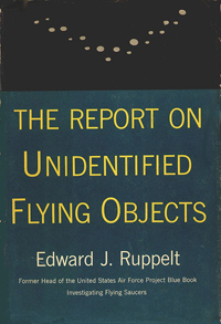
The U.S. Air Force’s investigation of the events in Washington, DC is best explained in a book written by the lead air force investigator, Captain Edward Ruppelt. Ruppelt—who was the head of the U.S. Air Force’s official UFO investigation department, Project Blue Book, from its inception in early 1952 until late 1953—published The Report on Unidentified Flying Objects in 1956.
The summer of 1952 was a busy time for the Blue Book investigators; Ruppelt referred to this period as, “The Big Flap.” Some of the most credible reports were coming from the Washington, DC area.
On July 10, a National Airlines crew reported a UFO over nearby Quantico, Virginia. They described the object as, “too bright to be a lighted balloon and too slow to be a big meteor.”
Then, on July 13, another commercial airline crew reported a UFO sixty miles southwest of Washington, DC. The crew was flying at 11,000 feet when they spotted a light below them. The object came up to their level, and when they turned on their headlights, it shot up in a steep climb.
The next day, on July 14, yet another commercial airline crew reported a UFO. This time it was during a flight from New York to Miami. While flying in the area of Newport News, Virginia, approximately 130 miles south of Washington, DC, the crew reported seeing eight UFOs.
Two days later, on the night of July 16, at around 9:00 p.m., a “high-ranking” scientist from the National Advisory Committee for Aeronautics Laboratory at Langley Air Force Base reported seeing a UFO with a friend. They were standing near the ocean when they saw two amber-colored lights off to their right. The lights were silently moving to the north. The scientist said they were “much too large to be aircraft lights.”
Ruppelt and his investigators had decided that this object would have been too big to be a plane given the description of the lights, and they could not find an answer as to what the scientists and his friend had seen. Ruppelt said it was a moot point, however, because the scientist “was a very famous aerodynamicist and of such professional stature that if he said the lights weren’t airplanes they weren’t.”
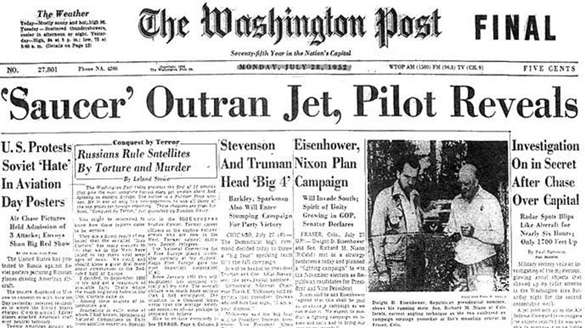
On July 20, Ruppelt was flying to Washington, DC on unrelated business. His plane landed at Washington National Airport in the morning, and he grabbed a paper to catch up on the latest news. There he found in big, bold, capitalized font, “INTERCEPTORS CHASE FLYING SAUCERS OVER WASHINGTON, D.C.”
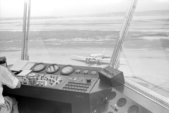
Washington National Airport control tower.
(Credit: Jack Delano/Library of Congress/Wikimedia Commons)
Ruppelt immediately called his superior officer at the Pentagon, Major Dewey Fournet, who told Ruppelt there was an investigation happening at Bolling Air Force Base. Rupplet headed there and received a briefing from the intelligence officer. At the meeting, they learned that at 11:40 p.m. the previous night, seven objects were caught on radar at Washington National Airport. At first, the radar operators thought the objects were a formation of planes, but nothing like that was scheduled. The objects moved slowly at about 100 to 130 miles per hour, but then would streak across the scope in sudden bursts of speed. The targets had moved all over the area, including over prohibited areas, such as the airspace over the White House and the U.S. Capitol building. One of the objects was clocked at speeds of more than 7,000 miles per hour.
The targets appeared to have flown near commercial airliners, and soon thereafter reports of strange lights were being reported by pilots. The first sighting from a pilot was from a Capital Airlines flight leaving Washington National Airport. The control tower asked the pilots of that airplane to keep an eye out for strange lights. During the flight, the pilot yelled, “There’s one—off to the right— and there it goes.” The radar correlated that an object had been tracked on the plane’s right side. The pilot reported seeing six more lights in the next fifteen minutes.
Several similar incidents took place that night. However, one of the more notable incidents was when the Washington National Airport traffic controller called the Andrews Air Force Base tower to tell them they were tracking an object south of the base. The tower operators looked out of their windows to see what they described as a “huge fiery-orange sphere” hovering in the sky.
F-94 Starfire. One of the types of jets scrambled to intercept the unknown objects.
(Credit: United States Air Force)
At the beginning of the excitement, once the Washington National Airport radar operators had determined their equipment was working properly, they began calling the air force to ask them to investigate. However, they didn’t receive a response. They called over and over, but the air force didn’t respond until daybreak the next morning. One interceptor checked out the area, but by then the UFOs were gone.
The events and the subsequent press coverage sent the U.S. Air Force into a state of pure confusion, complicated by bureaucratic bumbling. It was decided that Ruppelt would stay in Washington, DC to further investigate and formulate a response for the press, who was growing steadily impatient with the air force’s official “no comment” response. However, the USAF finance department would not improve the extension to his stay and sent him home.
Back in his office in Dayton, Ohio, Rupplet says he was too swamped with other UFO sightings to investigate the Washington DC incident. Several of these sightings also included jets being scrambled to check out the UFOs.
Then, exactly one week after the first major Washington, DC event, at about 10:00 p.m., Ruppelt received a call from Life Magazine’s UFO expert asking what the air force was going to do about that night’s UFOs. Ruppelt said, “I have no idea what the Air Force is doing; in all probability it’s doing nothing.”
He had heard anything about a new UFO event and guessed no one else in the air force had either. He called air force intelligence and the Pentagon, and he found out he was right. Several people from the Pentagon hurried out to Washington National Airport including the air force’s press chief Al Chop, Major Fournet, and a U.S. Navy electronics specialist assigned to the U.S. Air Force Directorate of Intelligence. All of them had a front row seat to the evening’s spectacular performance.
From left: Fournet, Chop, and Ruppelt.
Ruppelt had to wait until 5:00 a.m. the next morning to hear what had taken place. He was told at about 10:30 p.m. that Washington National Airport had once again picked up the slow-moving targets. The objects were in an arc surrounding the Washington, DC area. The objects spanned from Herndon, Virginia to Andrews Air Force Base. The same radar operators were present from the prior event, so they were prepared and worked quickly to mark and track the UFOs. They contacted Andrews Air Force Base who confirmed they were also tracking the objects.
At 11:30 p.m., it was decided to call in interceptors to check out the objects. Again they were slow to respond, but two Lockheed F-94 Starfires were in the air by midnight. At this point, reporters and photographers were asked to leave the radar room.
Ruppelt says the radar room was cleared because some of the air force officers thought this might be the night they got a good up-close look at a UFO.
Visibility that night was good. However, when the jets approached the targets, the objects disappeared from the radar screens. The jets returned to their base; however, a few minutes later, strange lights were seen near Langley Air Force Base. The lights were described as “rotating and giving off alternating colors.” The radar tower operators also saw the lights, so they called in an F-94 jet to check it out.
The jet pilot spotted the UFO’s lights and began moving towards it when the light disappeared. The pilot continued to fly around the area, and achieved a radar lock on an object, but whatever it was sped away. The same thing happened two more times.
Soon after the events near Langley Air Force Base, objects were again observed above Washington National Airport. Jets were scrambled again, but this time the objects stayed on radar as the jets approached. The tower controllers gave the jets the coordinates of the objects, but each time a jet closed in the objects would speed away.
This interaction continued for a few minutes until one object did not speed off. The F-94 pilot saw a bright light and hit his afterburners to try to pursue the object. However, as he got closer, the light just disappeared, and he could not get anything on his radar set.
The jets stayed in the area for twenty minutes, but finally ran low on fuel and had to return to the base. Dawn began to break, and soon the targets all disappeared.
The next day the press reported that fighter pilot, Lieutenant William Patterson, said,
I tried to make contact with the bogies below 1,000 feet, but [the radar controllers] vectored us around. I saw several bright lights. I was at my maximum speed, but even then I had no closing speed. I ceased chasing them because I saw no chance of overtaking them. I was vectored into new objects. Later, I chased a single bright light which I estimated about 10 miles away. I lost visual contact with it about 2 miles.
Ruppelt was informed that “everybody in the radar room was convinced that the targets were very probably caused by solid metallic objects. There had been weather targets on the scope too, he said, but these were common to the Washington area and the controllers were paying no attention to them.”
The papers were once again packed with headlines about the UFO chase. Ruppelt flew to Washington, and when he got to his hotel he was mobbed by reporters and photographers. With the help of a colleague he pushed his way to an elevator without making any comments.
According to Ruppelt, the U.S. Air Force was in a state of confusion. They all agreed that the UFO event should be investigated, but no one actually did anything about it. Unable to dodge the public’s fascination with the Washington events, on July 29, Major General Samford notified the press that he would have a press conference on the Washington UFO incidents. Ruppelt felt it a bit odd that none of the men in the radar room at Washington National Airport were involved in the press conference. Instead, the press conference was held by Major General Samford and another officer, neither of whom had been fully briefed.
Samford told the press that the UFO investigations had turned out to be mostly misidentifications, but that the other twenty percent of the reports that came in were from “credible observers of relatively incredible things.”
Edward Ruppelt (standing center) at July 29, 1952 Pentagon UFO press conference. Also pictured, Major Generals Roger Ramey (seated left), USAF operations chief, and John A. Samford (seated right), USAF director of intelligence.
(image credit: Wikipedia)
He said the air force would continue to investigate those reports, but they suspect that the Washington, DC events may have been false radar readings due to temperature inversions.
According to Ruppelt, the actually investigation ruled out temperature inversions. In fact, he discovered that every single night of the UFO sightings in Washington, DC, there was indeed a temperature inversion but none of these had previously been mistaken for UFOs.
Ruppelt also discovered that UFOs were a common occurrence in Washington, DC that summer. On May 23, from 8:00 p.m. until midnight, fifty unknown targets had been tracked on radar. There were several similar incidents throughout the summer, including the night of the press conference. As a result, to Ruppelt the objects could only be designated as “unknowns.”
Alleged pictures and videos of this event can be found on the internet. However, they are all either reflections or recreations of the events. No pictures or video was actually captured. However, the cases remain unsolved.
Image often mistaken for 1952 UFO encounter. The lights in the sky are actually reflections from the lights on the posts.
Ruppelt says this case convinced many that that UFOs were interplanetary spaceships.
If the objects over Washington DC in 1952 could not be explained, it seems obvious that an incursion of this sort would pose a threat to national security.
In the government’s UFO files there is a memo that claims the cases that posed a real threat were not included in the Blue Book files, and researchers have been tracking where those cases went.
They have discovered that the U.S. Air Force has taken UFO incidents seriously after the closing of Blue Book in 1969. And the cases that made it to this high-level reporting system are even more fascinating and alarming than the events in 1952.
We’ll take a look at this reporting system and the cases that have been discovered to have prompted its use in the next episode of Open Minds UFO Magazine.
Public interest in the possibility of unusual objects flying around in American airspace may be experiencing a resurgence thanks to the revelation that the Pentagon had been secretly funding investigations into the phenomena as recently as 2012, but the American military has already had a long and storied history of playing cat and mouse with mysterious lights in the sky (and elsewhere).
From sightings of “Foo Fighters” over the European theater in World War II to reports of Air National Guard P-51 Mustangs chasing lights through the skies of North Dakota in 1948, it’s clear that the United States military has had an interest in unexplained sightings reported by trained aviators dating back decades, and some would contend that this interest is justified. All professional pilots develop a keen understanding of norms in the sky, but military aviators—perhaps better than any—have been trained to look for and identify potential threats on the horizon. They know better than most what is and isn’t actually there, despite the sky’s propensity for weather-system-based tomfoolery.
It’s because of that trust in the judgment of military aviators that many of the most intriguing and long-lasting UFO-related mysteries tend to revolve around such reports. The eyewitness account of now-retired Navy Commander David Fravor regarding a series of attempted intercepts over the USS Nimitz carrier battle group in 2004, for instance, has served as an interesting—and troubling—addition to FLIR footage captured from the nose of his F/A-18 Super Hornet as he and another fighter attempted to intercept the unusual object that seemed to toy with them in the airspace around their carrier. The combination of video evidence, official Navy reports, and the clear and sober recollection of a fighter pilot have made the Nimitz incident perhaps the most prominent UFO sighting in modern history…but then, there have been some spectacular sightings in the past that seem to fall away from the American consciousness over time. That includes some that have involved scrambled fighters, official reports, and credible eyewitness accounts.
Back in July of 1952, while (it’s important to note) America was gripped by both the pop-culture phenomenon of “flying saucers” and a growing concern for Soviet aggression, a series of unusual blips appeared on the radar screens of Washington National Airport in the nation’s capital. These seven radar signatures were first spotted by controller Ed Nugent, who quickly got the attention of his supervisor, Harry G. Barnes.
“Here’s a fleet of flying saucers for you,” Nugent recalls kidding with his boss. Soon after spotting the strange readings on their radar screens, however, the humor in Nugent’s joke began to wain.
“Look at that bright light,” another flight controller, Joe Zacko, recalled interjecting in a 2002 interview. “If you believe in flying saucers, that could sure be one.”
Radar at two nearby military installations, Andrews Air Force Base and Bolling Air Force Base, both tracked the same objects. Soon, two Air Force F-94 fighter jets were scrambled to intercept these aircraft flying over the nation’s capital.
Lockheed F-94C Starfire at the National Museum of the United States Air Force. (U.S. Air Force photo)
“They acted like a bunch of small kids out playing,” Barnes, the head controller, wrote in a piece for a New York newspaper days after the incident. “It was helter-skelter, as if directed by some innate curiosity. At times, they moved as a group or cluster, at other times as individuals.”
The lights and radar returns promptly vanished. Unusual as it was, some may have been happy to forget about the incident and move on…but then it happened again the following weekend.
This time, it was a dozen blips on the radar screen and F-94s were promptly scrambled to intercept. As the fighters closed with the radar readings, a number of their pilots reported seeing lights in the sky that coincided with the technical data.
“I tried to make contact with the bogies below 1,000 feet,” pilot William Patterson later told investigators. “I was at my maximum speed but…I ceased chasing them because I saw no chance of overtaking them.”
Not all the pilots dispatched that night saw similar lights, however. One B-52 pilot passing through the airspace looked in the vicinity of one of the radar returns but saw only a small passenger boat bobbing along in the Potomac River—certainly nothing that could provide a return on radar screens from three separate airstrips.
These two incidents now had the nation, and its president, concerned. Headlines across the country brought the sightings to the nation’s attention. Stories out of Washington included “Radar Spots Air Mystery Objects Here” in the Washington Post and “Air Force ‘Saucer’ Expert Will Probe Sightings Here” in the Washington Daily News. The Cedar Rapids Gazette ran the headline, “SAUCERS SWARM OVER CAPITAL.”
“We have no evidence they are flying saucers,” an unnamed Air Force official reportedly told reporters. “Conversely, we have no evidence they are not flying saucers. We don’t know what they are.”
President Truman dispatched his Air Force aide, Brig. Gen. Robert B. Landry, to find out what these unusual objects were that kept flying over his house. Landry returned touting what would become the official Air Force line: The sightings were the result of a weather-related mirage.
The radar returns and the lights witnessed by pilots were formally attributed to a naturally occurring phenomenon known as temperature inversions.
“It’s very much like when you’re riding down the highway and it’s very hot out and you see a mirage on the highway,” explained Bruce Press of National Capital Area Skeptics, a group dedicated to debunking reports of the paranormal. “As you drive toward it, it doesn’t get any closer, so you assume that because it doesn’t get any closer, it’s moving away from you at the same speed you’re driving.”
Some aren’t as eager to dismiss the 1952 sightings, however, arguing that fighter pilots are trained observers that wouldn’t be so easily fooled by a weather system. Others, like Robert Swiatek of the Mutual UFO Network (MUFON) contend that the radar operators believed “the anomalous signals were good, solid targets, as though they were being reflected from the surface of metallic aircraft.”
Bruce Maccabee, a civilian physicist who worked for the U.S. Navy, counters those claims with another government report produced in 1969 called the “Quantitative Aspects of Mirages.”
“They proved in their own study that there wasn’t enough temperature inversion to cause this effect,” he says. “The Washington sightings cannot be explained as a radar mirage.”
Ultimately, for believers, the most frustrating thing about this pair of sightings over the nation’s capital in the summer of 1952 has been how quickly the American public forgot all about it. Some UFO sightings, like the infamous Roswell incident of 1947 or the “Phoenix Lights” of 1997, manage to worm their way into the American cultural identity, regularly resurfacing in discussion or debate. Somehow, though, the Washington incident of 1952 just never developed that level of notoriety.
Among believer and skeptic circles, however, the debate regarding this incident rages on as it does for every supposed sighting.
“You have dueling experts and dueling reports,” said Kevin D. Randle, who wrote the book “Invasion Washington: UFOs Over the Capitol.” “One expert says it was temperature inversion. Another says it wasn’t. In that situation, you have to refer back to the air traffic controllers and the pilots who actually saw the objects.”
I cover science and innovation and products and policies they create.
Shutterstock
A startup with alumni from MIT and Yale says it's made a breakthrough in creating a next-generation material that should make it possible to 3-d print literally anything out of thin air.
New York-based Mattershift has managed to create large-scale carbon nanotube (CNT) membranes that are able to combine and separate individual molecules.
"This technology gives us a level of control over the material world that we've never had before," said Mattershift Founder and CEO Dr. Rob McGinnis in a release. "For example, right now we're working to remove CO2 from the air and turn it into fuels. This has already been done using conventional technology, but it's been too expensive to be practical. Using our tech, I think we'll be able to produce carbon-zero gasoline, diesel, and jet fuels that are cheaper than fossil fuels."
CNTs have been identified as holding promise for a number of potential applications, from better golf clubs, fuels and medicines to far-out concepts like space elevators. A study published this week in the journal Science Advances confirms that Mattershift's large CNT membranes perform as well as the small prototypes we've seen so far.
The company says their breakthrough brings down the difficulty and cost of manufacturing the material, which should allow the technology to burst out of the confines of university labs.
"It should be possible to combine different types of our CNT membranes in a machine that does what molecular factories have long been predicted to do: to make anything we need from basic molecular building blocks," said McGinnis. "We're talking about printing matter from the air. Imagine having one of these devices with you on Mars. You could print food, fuels, building materials, and medicines from the atmosphere and soil or recycled parts without having to transport them from Earth."
A molecular factory is a long-predicted technology that, in theory, should be able to accomplish some of what the Replicator from "Star Trek" does, although not nearly as cleanly as on the show. Mattershift's approach is more about separating and combining molecules to form new raw materials, which is why working on creating fuels is a logical place to start.
But as McGinnis points out, if it works well there's no reason that more complex molecular factories can't be combined to become the future of manufacturing, and yes, maybe eventually serve up a drink out of thin air at some point by simply asking a future version of Alexa for "tea, earl grey, hot."
To jack in to my brain and get more on the latest in science, tech and innovation, follow me on Twitter @ericcmack
We don't understand the concept of time much at all.
Everyone experiences time — literally every day — but rigorous and comprehensive understanding of the topic is … lacking. Then again, we do know some things, especially when we look at time through the lens of specialandgeneral relativity. Einstein's work taught us many things: that space and time are connected, that you can never travel faster than light, that our universe has a finite age and that different observers experience different lengths of time.
All these revelations lead to some interesting questions. It's time (pun intended) for a roundup.
Our universe is 13.77 billion years old, according to our current best estimates, which are very good, thank you very much. But when special relativity is invoked, we also understand that everyone measures time differently, depending on their speed. We, on Earth, whizzing around the sun, with the sun spinning around the Milky Way, and the Milky Way blasting through the intergalactic vacuum, should have a different perspective on the flow of time than someone else on a different planet around a different sun in a different galaxy. That said, how can we possibly pin down a "real" age of the universe?
Here's the trick. Yes, according to special relativity, different observers have different measures of time. But our whole entire universe is not fully described by special relativity. The tools that we use to understand matters cosmological are provided by its bigger brother, general relativity. And when we look at the history of the universe from general relativity's viewpoint, we find that the cosmos … well, has a history.
Our universe expands with time. It was smaller in the past, and it will be bigger in the future. There's a direct connection between a particular moment in time and a particular size of the universe. This allows us to construct what amounts to a universal clock, a timepiece that has been ticking away for over 13 billion years.
Yes, the motion of Earth through the universe changes that clock slightly, but with the tools of general relativity, we can essentially subtract that out and work out the "real" age of the universe … and so can any other observer in the cosmos (assuming that they've also cracked general relativity, but that's on them)
Does light experience time?
Moving clocks run slow. The faster you move in space, the slower you move in time. This is one of the most amazing results from Einstein's special relativity theory, and it's one way of visualizing the unique relationship between time and space. This "time dilation" effect is totally unnoticeable at speeds you'll typically encounter (hopefully) in everyday life. It's only once you get up close to the speed of light that time seems to go a little wonky.
So, if time slows down for you the faster you get to the speed of light, what about light itself? It's moving at the maximum posted speed limit of the universe. Does light … not experience time at all?
Kind of, but also not quite. Our knowledge of the relationship between time and space rests in what's wrapped up in special relativity. And while the theory produces all sorts of crazy results, it's grounded in some very simple ideas, the most important of which is the concept of the universality of physical laws: What goes for one observer, at a fundamental level, goes for all.
And one thing we know in physics, via Maxwell's equations, is that the speed of light is constant. Every observer, no matter their speed, will measure the exact same speed for light.
So, if we want to apply our knowledge of special relativity to movement at the speed of light, we run into a little sticking point. In order to ask the question, "How does light experience time?" you have to put yourself in a frame of reference that rides along with a beam of light. But in that frame of reference, light would appear to be stationary to you.
That's not allowed by our laws of physics. So there is no such frame of reference that rides along with light. And with no frame of reference, special relativity breaks down. And with no special relativity, you have no way of gauging the relationship between space and time.
The end result of all this twisting? It's not so much that light doesn't experience time. It's that our very concept of time doesn't even apply to light.
Light doesn't even know what time is.
Which twin is right?
One twin jets off close to the speed of light. The other stays at home. The faster of the pair blasts around the galaxy, having a ball, before returning to the boring ball of Earth. The other … does laundry.
According to the rocket twin, maybe a few weeks or months elapsed on ship time. A long trip, for sure, but nothing serious. But the ground-bound twin suffered years, even decades, of agonizing solitude.
This part's not surprising. Moving clocks run slow and all that. According to the twin left on Earth, the rocket twin moved close to the speed of light — and thus had a slower clock.
But wait. The twin on the rocket could rightly claim that they were the stationary one, and the whole universe, including the Earth twin, were the ones to move. Relativity is relativity, after all. Nobody's perspective is especially special. So according to that twin, the one on Earth should've barely aged at all.
Who wins the age argument?
The lonely, unadventurous, Earth-bound twin does, and they do because theydidn't turn around. As long as the rocket-loving twin stayed moving in a single direction, their perspectives were exactly symmetric, with each having their own unique perspective that they could rightly call correct. But once that rocket slowed, stopped and reversed, the symmetry broke. Their perspectives were no longer mirrors. The twin on the rocket would see the horrible reality catch up to him in a blink: The Earthbound twin had aged, too much, and there was nothing they could do about it.
Learn more by listening to the episode "What happens when galaxies collide?"on the Ask A Spaceman podcast, available on iTunes and on the Web at http://www.askaspaceman.com. Thanks to Kandi M., Mihail E., Men B., Carlos D., Alan P., Derrick M., Rose J., Kirk B., Rueben F., Chris F., Diego S., and R. S.for the questions that led to this piece! Ask your own question on Twitter using #AskASpaceman or by following Paul @PaulMattSutter and facebook.com/PaulMattSutter.
Future spaceships could use black holes as powerful launch pads to explore the stars.
A new study envisions firing laser beams that would curve around a black hole and come back with added energy to help propel a spacecraft to near the speed of light. Astronomers could look for signs that alien civilizations are using such a "halo drive," as the study dubs it, by seeing if pairs of black holes are merging more often than expected.
Study author David Kipping, an astrophysicist at Columbia University in New York, came up with the idea of the halo drive through what he calls "the gamer's mindset."
"Sometimes, in a computer game you find an 'exploit,' a hack which allows you to do something overpowered that would otherwise be forbidden by the rules of the game," Kipping told Space.com. "In this case, the game is the physical world, and I tried to think about exploits that would allow a civilization to achieve relativistic flight back and forth across the galaxy without the vast energy expense that one might naively assume."
A key challenge to using rockets to fly through space is that the propellant they carry with them has mass. Long trips need a lot of propellant, which makes the rockets heavy, which in turn requires more propellant, making the rockets even heavier, and so on. That problem gets exponentially worse the bigger the rocket gets.
Instead of carrying propellant for propulsion, however, spacecraft equipped with mirror-like sails could rely on lasers to push them outward. The $100 million Breakthrough Starshot initiative, announced in 2016, plans to use powerful lasers to propel swarms of spacecraft to Alpha Centauri, the closest star system to our own, at up to 20 percent the speed of light.
The spacecraft that Breakthrough Starshot aims to launch are each only about the size of a microchip. In order to accelerate larger spaceships to relativistic speeds — to a significant fraction of light speed — Kipping sought the aid of gravity.
Spacecraft now regularly use "slingshot maneuvers," in which the gravity of a body, such as a planet or moon, hurls the vessels across space and boosts their speed. In 1963, famed physicist Freeman Dyson suggested that spaceships of any given size could rely on slingshot maneuvers around compact pairs of white dwarfs or neutron stars to fly at relativistic speeds. (Dyson came up with the notion of what became known as a Dyson sphere, a megastructure that encapsulates a star to capture as much of its energy as possible to power an advanced civilization.)
However, a "Dyson slingshot" runs the risk of damaging a spacecraft through extreme gravitational forces and hazardous radiation from those pairs of dead stars. Instead, Kipping suggests that gravity might assist spaceships by increasing the energy of laser beams fired at the edges of black holes.
Black holes possess gravitational fields so powerful that nothing can escape them once it gets close enough, not even light. Their gravitational fields can also distort the paths of photons of light that do not fall into the holes.
In 1993, physicist Mark Stuckey suggested that a black hole could, in principle, act like a "gravitational mirror," in that the black hole's gravity could slingshot a photon around so that it flew back at its source. Kipping calculated that if a black hole was moving toward a photon's source, the "boomerang photon" would siphon away some of the black hole's energy.
Using what he called a "halo drive" — named for the ring of light it would create around a black hole — Kipping found that even spaceships with the mass of Jupiter could achieve relativistic speeds. "A civilization could exploit black holes as galactic waypoints," he wrote in a study accepted by the Journal of the British Interplanetary Society and detailed online Feb. 28 in the arXiv preprint server.
The faster a black hole moves, the more energy a halo drive could draw from it. As such, Kipping largely focused on using pairs of black holes spiraling toward each other before a merger.
Astronomers could look for signs that alien civilizations are exploiting pairs of black holes for travel with such an engine. For example, halo drives would effectively steal energy from such binary black hole systems, increasing the rates at which pairs of black holes merge above what one would expect to see naturally, Kipping said.
His findings were based on boosts from pairs of black holes orbiting each other at relativistic speeds. Although there are an estimated 10 million pairs of black holes in the Milky Way, Kipping noted that few of those likely orbited at relativistic speeds for long, since they would merge rather quickly.
Still, he noted that isolated, spinning black holes could also launch halo drives at relativistic speeds, "and we already know of numerous examples of relativistic, spinning supermassive black holes."
The major drawback of a halo drive would be that "one has to travel to the nearest black hole," Kipping said. "It's akin to paying a one-time toll fee to ride the highway system. You have to pay some energy to reach the nearest access point, but after that, you can ride for free as a long as you like."
The halo drive works only in close proximity to a black hole, at a distance of about five to 50 times the black hole's diameter. "This is why you have to travel to the nearest black hole first and [why you] can't simply do this across light-years of space," Kipping said. "We still first require a means to travel to nearby stars to ride the highway system.
"If we want to achieve relativistic flight, it takes immense energy levels no matter what propulsion system you use," he added. "One way to get around this is to use astronomical objects as your power source, since they possess literally astronomical levels of energy within them. In this case, the black-hole binary is essentially a giant battery waiting for us to tap it. The idea is to work with nature and not against it."
Kipping is now investigating ways to exploit other astronomical systems for relativistic flight. Such techniques "may not be quite as efficient or fast as the halo-drive approach, but these systems possess the deep energy reserves needed for these journeys," Kipping said.
The stellar spinner is a magnetar, which is a type of neutron star — a Manhattan-size remnant of a larger star, and the densest type of object besides black holes that we've detected anywhere in the universe.
This particular magnetar is called XTE J1810–197. It's one of only 23 magnetars and one of just four radio magnetars ever discovered, and it first turned up in 2004. Then, in late 2008, it went dormant and no longer emitted radio waves. On Dec. 8, 2018, it woke up again, and it's a bit changed. The researchers who spotted its awakening reported their finding in a paper uploaded March 6 to the preprint server arXiv.
Astronomers have long believed such magnetars carry magnetic fields more than a million times more intense than typical neutron stars and more than a quadrillion times more powerful than Earth's own. Those magnetic fields seem to be the source of intense flashes of electromagnetic energy we can detect from Earth as the magnetar spins. [7 Surprising Things About the Universe]
(Other neutron stars also emit regular flashes of energy, which gives them their second name, pulsars.)
Even so, scientists don't know why XTE J1810–197's radio emissions went to sleep or why they woke up; magnetars are among the rarest and least-well-understood objects in humanity's stellar catalog. But in the two months since its reappearance, it's behaved significantly differently than it did between 2004 and 2008.
When XTE J1810–197 last flashed across human telescopes, it acted erratically, wildly shifting its pulse profile over relatively short time periods. Now, its behavior is more stable, the astronomers reported. At the same time, the torque spinning the star has seemed to increase significantly — a trait the researchers said is common to pulsars after their dormant periods.
One remarkable aspect of XTE J1810–197's reappearance is that astronomers might have missed it. From the perspective of Earth, the magnetar is in the same part of the sky as the sun is right now. So the soft pulses announcing its reawakening were too soft to trip any general-purpose detectors watching the sky at that time. Against the sun's bright electromagnetic blast, XTE J1810–197 was barely a blip.
But a team of astronomers led by Lina Levin of the University of Manchester in the U.K. had tasked a radio telescope with periodically observing the pulsar ever since it went silent. And, more than a decade later, that close scrutiny has paid off. Levin and her team noticed what others had missed.
The researchers also reported oscillations in the radio signal that might be the result of waves rushing across the surface of the distant magnetar.
Historyhas given the greenlight toUnidentified: Inside America’s UFO Investigation, a six-part docuseries that the network says will expose new evidence about the U.S. government’s secret program investigating the UFO phenomenon. The series will premiere sometime in May.
Unidentified, from A&E Originals, will be executive produced by Tom DeLonge, co-founder and president of To the Stars Academy of Arts & Science, who along with former Deputy Assistant Secretary of Defense and Intelligence Chris Mellon and their team will provide new information about UFO encounters and embark on new investigations.
It will include the first interview with former military intelligence official Luis Elizondo, who in 2017 in a New York Times report confirmed the existence of the Advanced Aerospace Threat Identification Program, a hidden Pentagon government unit that he directed. He eventually resigned after expressing to the government that the Unidentified Aerial Phenomena the program investigated could pose a major threat to national security.
“With this show, the real conversation can finally begin,” said Delonge of the series, which will reveal newly authenticated evidence and footage, as well as interviews from eyewitnesses and former military personnel. “I’m thankful to History for giving the To The Stars Academy team of world-class scientists, engineers and intelligence experts the opportunity to tell the story in a comprehensive and compelling way. I think everyone that watches the show will walk away with questions answered and a feeling of, ‘Wow, I get it now.’ “
Steve Ascher, Kristy Sabat and Anthony Lappé are executive producers for A+E Originals. Mike Stiller serves as executive producer for History.
DeLonge is repped by APA, Management 360 and Jackoway Austen.
BILL CLINTON AND UFOS: DID HE EVER FIND OUT IF THE TRUTH WAS OUT THERE?
In 1999, the House of Representatives passed a bill that would have required across-the-board cuts to most federal agencies and departments, including the Department of Education, which President Clinton learned about as he was about to meet with a delegation of educators. The budget cuts also meant that teachers would probably not be getting any raises, something that irked Clinton to the point where, in an impromptu and unscripted remark, he said, channeling Ronald Reagan’s famous statement, “If we were being attacked by space aliens, we wouldn’t be playing these kinds of games.” Funny how when Ronald Reagan said the same thing to the United Nations, folks commented that Reagan sure knew how to illustrate a point. When Clinton made his statement, Rush Limbaugh thundered into his microphone, “What’s he going to do, arrange one?”
Just three years earlier, while on a trip to Ireland where he was visiting a very troubled Belfast, Clinton read a letter he received from a child named Ryan, who had asked him about what he knew regarding stories of a UFO crash at Roswell, New Mexico. Clinton hadn’t come to talk about UFOs. He was trying to make a point regarding how children can be victimized by political violence. In front of his Belfast audience, Clinton said to Ryan, “No, as far as I know, an alien spacecraft did not crash in Roswell, New Mexico, in 1947.” But then he added, to the delight of his audience, “and Ryan, if the United States Air Force did recover alien bodies, they didn’t tell me about it, either, and I want to know.”
Clinton did want to know, Webster Hubbell, Clinton’s associate attorney general, wrote in his own memoir. As AAG, Hubbell claimed that President Clinton asked him to find out all that he could about two things: who killed JFK and what the government knew about UFOs. He reported to the president after being stonewalled by the relevant agencies that there was a secret government that closely holds secrets to which the president doesn’t even have access.
Bill Clinton talks about UFOs and Area 51 again
Even though it is Jimmy Carter who famously had a UFO sighting, Bill Clinton seems to be the one who talks the most about them, and he is open to the idea of extraterrestrial visitation. He has a long history of association with the UFO subject and Area 51 that spans back throughout his presidency.
UFO buffs, and reporters, where poised at their televisions last night, ready to find out if Jimmy Kimmel would keep his promise when the other night he said he would ask Clinton about UFOs when he came on the show. Kimmel kept his promise, and in typical Kimmel fashion, in a light hearted and funny way. However, he did get some interesting and heartfelt comments from the former president.
Kimmel brought up the subject by saying that if he were president he would immediately go find out about UFOs. He said, “I probably wouldn’t even finish the oath. I would run to the White House. I’d demand to see all of the classified files on the UFOs because I want to know. I want to know what has been going on. Did you do that?”
Clinton replied, “Sort of.”
Clinton said he began looking into it at the beginning of his second term, during the 50thanniversary of the alleged Roswell UFO crash. Kimmel was surprised he waited so long. Clinton also said he looked into Area 51.
Clinton says there was a sci-fi movie that about an alien being held in Area 51. So he says he first had people look into Area 51 to find out if there really was an alien down there. He says he found out it was a secret base and the people who worked there even had to wear special clothing, but they were dealing with secret stealth technology, not aliens.
As for Roswell, he says he knew they were going to receive “zillions” of letters about it for the anniversary, so he had all of the Roswell papers reviewed. Clinton didn’t get into the results of that inquiry before Kimmel’s next question, but we do know from previous comments that Clinton says he found no evidence of aliens at Roswell either. More on the later…
As soon as Clinton mentioned he had the Roswell files reviewed, Kimmel asked, “If you saw that there were aliens there would you tell us?”
Clinton replied that he would, to which the crowd clapped. He then said:
What do we know now? We know we live in an ever expanding universe. We know that there are billions of stars and planets, literally, out there, and the universe is getting bigger. We know from our fancy telescopes that just in the last two years more than 20 planets have been identified outside of our solar system that seem to be far away enough from their suns and dense enough that they might be able to support some form of life. So, it makes it increasingly less likely that we are alone.
Kimmel suggested, “Oh, you are trying to give me a hint that there are aliens.”
Clinton replied, “No, I am trying to tell you I don’t know, but if we were visited some day I wouldn’t be surprised. I just hope it’s not like Independence Day the movie. “
Finally, Clinton embarked some sentiments, similar to those given by Reagan in the 80s and repeated several times, that if there was an alien threat that humans would need to unite and forget our petty difference. He noted that was the point behind the Independence Day movie.
Clinton’s UFO History
Clinton wasn’t kidding when he says he looked into UFOs during his presidency. In fact, a story that would make Kimmel proud was printed in a book by Clinton’s friend William Hubbell.
Hubbell was a friend of the Clintons from Arkansas, and was actually indicted for fraud in the Whitewater scandals. Before his indictment he was assigned to the Attorney General’s office as the Associate Attorney General. Hubbell wrote in his book Friends in High Places:
Clinton had said, ‘”If I put you over at Justice, I want you to find the answers to two questions for me,” Hubbell recounts. “One, who killed JFK. And two, are there UFOs?” Clinton was dead serious. I had looked into both, but wasn’t satisfied with the answers I was getting.
In a speech he gave in Belfast in Northern Ireland in 1995, Clinton brought up Roswell. He said, “I got a letter from 13-year-old Ryan from Belfast. Now, Ryan, if you’re out in the crowd tonight, here’s the answer to your question. No, as far as I know, an alien spacecraft did not crash in Roswell, New Mexico, in 1947. And, Ryan, if the United States Air Force did recover alien bodies, they didn’t tell me about it, either, and I want to know.”
Someone else who wanted to know was Laurence Rockefeller. Laurance, one of the Rockefeller heirs, worked diligently during Clinton’s administration to fund research into UFOs, and to get official government information released.
Laurance, who passed in 2004, was by no means a black sheep of the powerful Rockefeller family. He held a seat on the New York Stock Exchange, and was the founding trustee of the Rockefeller Brothers Fund for forty-two years. He was a venture capitalist who was involved with, among other things, the rise of the computer era. He helped shape history, and before he passed he wanted the public to be informed about UFOs.
Researcher Grant Cameron, who runs the website HillaryClintonUFO.net, was able to retrieve documents through the Freedom of Information Act that showed Rockefeller was soliciting help from Hillary’s staff on drafting a document to President Bill Clinton in 1995. The title of the document was Lifting Secrecy on Information About Extraterrestrial Intelligence as Part of the Current Classification Review.
The Clintons never did publicly involve themselves with Rockefeller’s quest for UFO truth, but like he told Kimmel, Clinton did make his own inquiries. Another time when he discussed his Area 51 and Roswell investigation was after his presidency in Hong Kong in 2005.
Clinton took part in a Q and A session with an audience for CLSA Asia-Pacific Markets, a large independent equity broker and financial services group. The moderator asked Clinton if there was a list that was passed from president to president with a list of secrets like “’Where is Jimmie Hoffa?” and “What really happened at Roswell?” He added, “Is there something for us to look forward to that will be released that will make the National Inquirer required reading?”
Clinton chuckled, and although he wasn’t asked about it, his answer mostly referenced Area 51:
Well, I don’t know if you all remember this, but there was actually, when I was president in my second term, there was an anniversary observance of Roswell. You Remember that? People came to Roswell, New Mexico from all over the world. And, um… and there is also a site in Nevada where people were convinced that the government had buried a UFO and perhaps an alien deep underground, because we wouldn’t allow anybody to go there. And um… I can say now, because it has now been released into the public domain, I actually had so many people in my own administration convinced that Roswell was a fraud, but this place in Nevada was really serious, there was an alien artifact there. So, I actually sent someone there to figure it out, and it was actually just a secret defense installation, alas, doing boring work that we just didn’t want anybody else to see.
This wasn’t the first time Clinton referenced Area 51. He was forced to do so in 1994. Due to the burning of unknown chemicals at Area 51, several civilian contractors got sick and two of them died. Five of these employees, who remained unnamed, and the families of two of the deceased sued the US Air Force and the EPA in 1994.
The Air Force had a difficult time denying the existence of the base to the media, while at the same time acknowledging the law suit existed. Because of its secret nature, the Air Force said they could not reveal the chemicals that were being burnt at the base, and President Clinton reinforced this decision with a Presidential Determination which exempted “The Air Force’s Operating Location Near Groom Lake, Nevada” from environmental disclosure laws. Thus, the victims’ case was dismissed due to a lack of evidence. The determination requires being reviewed and renewed every year, and every president since Clinton has done so.
The determination did not include the name Area 51, because the name of the base was officially classified until recently. In fact, President Obama had the honor of being the first president to speak the name of the base. Clinton’s appearance on the Jimmy Kimmel may, in fact, be the first time he has uttered those words in public.
Clinton’s UFO Buddy
Johh Podesta was Bill Clinton’s chief of staff and aided in Obama’s transition into the White House in 2008, and is currently a White House advisor. He is also known to be a sci-fi enthusiast, and has been involved with efforts to get the government to disclose all it knows about the UFO phenomenon.
John Podesta (Image from www.americanprogress.org)
Podesta served on Clinton’s staff from 1993 until Clinton left office. His final position was as Clinton’s Chief of Staff. He has remained influential in politics through a liberal think tank that he founded called the Center for American Progress.
It has always been known that Podesta is a big sci-fi buff. He made headlines during his tenure in the White House when he had an X-files themed birthday party. He was especially keen on that TV series. For a man at his level to have an interest in sci-fi is not that unusual. However, the depth of his interest in UFOs was revealed when he spoke at a press conference at the National Press Club asking the government to release its secret files on UFOs so that scientists can determine the nature of the phenomena.
In 2002 the Coalition for the Freedom of Information headed by journalist Leslie Kean, along with the Sci-Fi channel (now SyFy), held a press conference at the National Press Club in Washington D.C. to address the issue of secrecy regarding the subject of UFOs. At that meeting Podesta stated, “It is time for the government to declassify records that are more than 25 years old, and to provide scientists with data that will assist in determining the real nature of this phenomenon.” He made this comment in front of several major media representatives in attendance. The video can be seen below.
Clinton by far, more than any other president, has demonstrated the biggest presidential interest in UFOs. Every time he has talked on the subject he has left open the possibility that there could be more to the subject than we know. It seems he has been open to the idea of alien visitation for some time, even before it was cool. And yes, it is now very cool to believe in aliens.
Meer van UFO'S of UAP'S, ASTRONOMIE, RUIMTEVAART, ARCHEOLOGIE, OUDHEIDKUNDE, SF-SNUFJES EN ANDERE ESOTERISCHE WETENSCHAPPEN - DE ALLERLAATSTE NIEUWTJES


 Bernese Mars camera CaSSIS returns spectacular images