Naar de inhoud

UFO'S of UAP'S, ASTRONOMIE, RUIMTEVAART, ARCHEOLOGIE, OUDHEIDKUNDE, SF-SNUFJES EN ANDERE ESOTERISCHE WETENSCHAPPEN - DE ALLERLAATSTE NIEUWTJES

UFO's of UAP'S in België en de rest van de wereld
akke.beakke.be
Ontdek de Fascinerende Wereld van UFO's en UAP's: Jouw Bron voor Onthullende Informatie! Ben jij ook gefascineerd door het onbekende? Wil je meer weten over UFO's en UAP's, niet alleen in België, maar over de hele wereld? Dan ben je op de juiste plek! België: Het Kloppend Hart van UFO-onderzoek In België is BUFON (Belgisch UFO-Netwerk) dé autoriteit op het gebied van UFO-onderzoek. Voor betrouwbare en objectieve informatie over deze intrigerende fenomenen, bezoek je zeker onze Facebook-pagina en deze blog. Maar dat is nog niet alles! Ontdek ook het Belgisch UFO-meldpunt en Caelestia, twee organisaties die diepgaand onderzoek verrichten, al zijn ze soms kritisch of sceptisch. Nederland: Een Schat aan Informatie Voor onze Nederlandse buren is er de schitterende website www.ufowijzer.nl, beheerd door Paul Harmans. Deze site biedt een schat aan informatie en artikelen die je niet wilt missen! Internationaal: MUFON - De Wereldwijde Autoriteit Neem ook een kijkje bij MUFON (Mutual UFO Network Inc.), een gerenommeerde Amerikaanse UFO-vereniging met afdelingen in de VS en wereldwijd. MUFON is toegewijd aan de wetenschappelijke en analytische studie van het UFO-fenomeen, en hun maandelijkse tijdschrift, The MUFON UFO-Journal, is een must-read voor elke UFO-enthousiasteling. Bezoek hun website op www.mufon.com voor meer informatie. Samenwerking en Toekomstvisie Sinds 1 februari 2020 is Pieter niet alleen ex-president van BUFON, maar ook de voormalige nationale directeur van MUFON in Vlaanderen en Nederland. Dit creëert een sterke samenwerking met de Franse MUFON Reseau MUFON/EUROP, wat ons in staat stelt om nog meer waardevolle inzichten te delen. Let op: Nepprofielen en Nieuwe Groeperingen Pas op voor een nieuwe groepering die zich ook BUFON noemt, maar geen enkele connectie heeft met onze gevestigde organisatie. Hoewel zij de naam geregistreerd hebben, kunnen ze het rijke verleden en de expertise van onze groep niet evenaren. We wensen hen veel succes, maar we blijven de autoriteit in UFO-onderzoek! Blijf Op De Hoogte! Wil jij de laatste nieuwtjes over UFO's, ruimtevaart, archeologie, en meer? Volg ons dan en duik samen met ons in de fascinerende wereld van het onbekende! Sluit je aan bij de gemeenschap van nieuwsgierige geesten die net als jij verlangen naar antwoorden en avonturen in de sterren! Heb je vragen of wil je meer weten? Aarzel dan niet om contact met ons op te nemen! Samen ontrafelen we het mysterie van de lucht en daarbuiten.

Categorie: ARCHEOLOGIE ( E, Nl, Fr )

Earliest Homo Looked Nothing Like A Human, Skeleton Suggests

Earliest Homo Looked Nothing Like A Human, Skeleton Suggests

Homo habilis reconstruction from previous ideas

For decades, Homo habilis has been treated as the “starter” version of our genus - more humanlike skull and teeth, plus the stone tools often found in the same broad time range. But a newly described partial skeleton is now pushing back hard on the idea that early Homo would have looked recognizably human from the neck down.

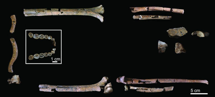
The fossil assemblage, found at Koobi Fora on the eastern side of Lake Turkana in Kenya, includes around 100 bones from the upper body and parts of the pelvis, associated with a near-complete lower jaw and teeth. Together, they make up the most complete H. habilis skeleton yet described, known as KNM-ER 64061, reports Science.

What has emerged in the recent study report published in The Anatomical Record, is a hominin that still carried a surprisingly “primitive” build: long, powerful arms and thick bone walls that echo earlier australopiths. In other words, early Homo may have been equipped with a more modern head while keeping a body that wouldn’t pass for human at a distance. 

The Koobi Fora skeleton: what was found, and why it matters

The Koobi Fora remains were first recovered in 2012, beginning with a tooth and then a substantial set of lower teeth; additional bones lay scattered downslope. A key hurdle was proving that the jaw and the limb bones belonged to the same individual - a recurring problem in sites where fossils can be moved and mixed over time.

Researchers report that CT scans revealed matching mineral “fingerprints” (including barite) on the jaw and arm bones, strengthening the case that the pieces belong together. That allowed the team to treat KNM-ER 64061 as a single individual and, critically, to interpret proportions rather than isolated fragments. 

A replica of the skull of Homo habilis

The characteristics of Homo habilis were previously only estimated from skulls and a few fragmentary skeletons.

Image credit: Danny Ye/Shutterstock.com

In the technical description, the authors emphasize that the skeleton includes clavicle and shoulder-blade fragments, both upper arms, both forearms, plus part of the sacrum and hip bones - rare coverage for H. habilis, which has long been known mostly from cranial and dental material.

Skeletal remains of KNM-ER 64060 and KNM-ER 64061

Skeletal remains of KNM-ER 64060 and KNM-ER 64061, the most complete H. habilis skeleton yet studied.

(Grine, F. E. et al./ The Anatomical Record)

Long arms, thick bone - and a body built differently than H. erectus

The new skeleton reinforces an uncomfortable point for the classic narrative: the tall, long-legged, “human body plan” seems to arrive later than many textbook summaries suggest. The team reports that H. habilis retained relatively long forearms compared with Homo erectus, and that its upper-limb bones have strikingly thick cortices (dense outer bone walls), a trait more reminiscent of australopiths, explains the study. 

That does not automatically mean KNM-ER 64061 was swinging through trees like an ape - researchers caution against turning anatomy into simple lifestyle storytelling. Still, long arms and robust upper limbs hint that climbing or heavy upper-body loading remained important in its daily life, even while stone tools were spreading across the landscape. 

At the same time, a small but telling detail in the pelvis - an ischium fragment - suggests more efficient hip mechanics for upright walking than in australopiths. It’s a mosaic: not “human,” not “ape,” but a blend that complicates any straight-line march toward modern human anatomy. 

Old idea of how Homo habilis would have looked.

Homo habilis would NOT have stood and looked like this.

(Homo habilis Leakey et al 1964/Public Domain) 

Rethinking early Homo: who made the “human” body?

One reason this fossil matters is timing. H. erectus appears around 2 million years ago, while H. habilis persists much later, meaning they overlapped for a long time rather than forming a neat ancestor–descendant chain. That overlap makes it harder to argue that habilis simply “became” erectus through gradual body reshaping. 

Instead, the new skeleton supports an increasingly common view: early Homo was diverse, and different lineages may have tested different solutions - some emphasizing brain and dental changes, others moving toward the long-legged form suited to long-distance walking. The Anatomical Record paper even provides estimates that highlight the physical gap: about 160 cm tall, but only roughly 31–33 kg in body mass for this individual, noticeably lighter than typical estimates for H. erectus.

If so, the truly “human-looking” body may not have been a starting feature of our genus at all, but a later evolutionary package, one that appeared after early tool use had already begun, and after multiple hominin species shared the same East African landscapes. 

  • Top image: Bangkok, Thailand, Homo habilis reconstruction at Rama9 museum.        
  •  Source: Akkharat J./Adobe Stock

By Gary Manners

References


Earliest Homo Didn’t Look Human Homo Habilis & the Forgotten Body Plan

{ https://www.ancient-origins.net/ }

Hoe vind je dit bericht?
Geschreven door peter om 23:06 Stuur door

De 10 coolste ondergrondse steden ter wereld

De 10 coolste ondergrondse steden ter wereld

Spannend: de 5 coolste ondergrondse steden ter wereld

Er zijn verschillende indrukwekkende ondergrondse steden over de wereld waar mensen daadwerkelijk hebben gewoond, zoals Derinkuyu in Turkije en de zoutmijn van Wieliczka in Polen.

1. Derinkuyu, Cappadocië, Turkije

Verreweg de bekendste ondergrondse stad is Derinkuyu in Turkije, onderdeel van het schitterende Cappadocië. In Cappadocië stikt het van de ondergrondse schatten, maar Derinkuyu is met 85 meter de diepste. Het complex bestaat uit verschillende kamers, kerken en wijnkelders, en biedt plek aan maar liefst 20.000 mensen. Ga met een gids naar beneden om het indrukwekkende gangenstelsel te bekijken.

Cappadocië stad, gelegen in het centrum van Turkije, is de thuisbasis van niet minder dan 36 ondergrondse steden, en op een diepte van ca., 85 m, Derinkuyu is de diepste. Ontdekt in 1963, het ondergrondse netwerk van tunnels en kamers omvatten alle instellingen en kamers die u zou vinden in een reguliere stad: woonvertrekken, stallen, kerken, opslagruimtes, refter, en wijnhuizen – en de ondergrondse wordt gezegd dat mogelijk gehouden meer dan 20.000 mensen.

Geopend voor het publiek in 1965, is slechts 10% van de ondergrondse stad toegankelijk voor bezoekers. Uniek aan Derinkuyu is de kruisvormige kerk gelegen tussen het derde en vierde niveau en het gewelfde plafond, aangezien er ter plaatse niet veel informatie rondhangt, boek dan een rondleiding en begin met verkennen.

2. Dixia Cheng, China

Dixia Cheng is de naam van de ondergrondse stad in Beijing en werd aangelegd tijdens de Koude Oorlog. In de jaren 70 werd hier een reusachtig netwerk aan gangen aangelegd, dat toegankelijk was via meer dan 100 geheime ingangen. Het complex bestaat grotendeels uit slaapzalen, ziekenhuizen en scholen en tot voor kort kon je er als toerist een kijkje nemen. Helaas is deze ondergrondse stad nu gesloten voor het publiek en het is onduidelijk wanneer je er weer een kijkje kan nemen.

De ondergrondse stad van Peking, Dixia Cheng, werd gebouwd in de jaren 1970 om te dienen als schuilplaats tijdens invasies, bomaanslagen en nucleaire aanvallen. Het lange netwerk van tunnels, vaak aangeduid als de ondergrondse grote muur, omvatte bijna 100 verborgen ingangen en, naar verluidt, werden gebouwd met complete diensten zoals scholen, ziekenhuizen en slaapzalen voor het geval burgers nodig hadden om hun toevlucht te zoeken voor een langere periode van tijd., Gelukkig was er nooit een gelegenheid voor deze enorme ondergrondse schuilplaats om zijn doel te bereiken, en in 2000 werd de plaats geopend voor het publiek. Een tour omvat slechts een klein rond stuk van het complex, maar is nog steeds het aantrekken van reizigers uit de hele wereld. Dixia Cheng is onder renovatie sinds 2008 en daarom gesloten voor bezoekers, maar zorg ervoor dat u het op uw bucket list te controleren wanneer het heropent op een onbepaalde datum in de toekomst.,

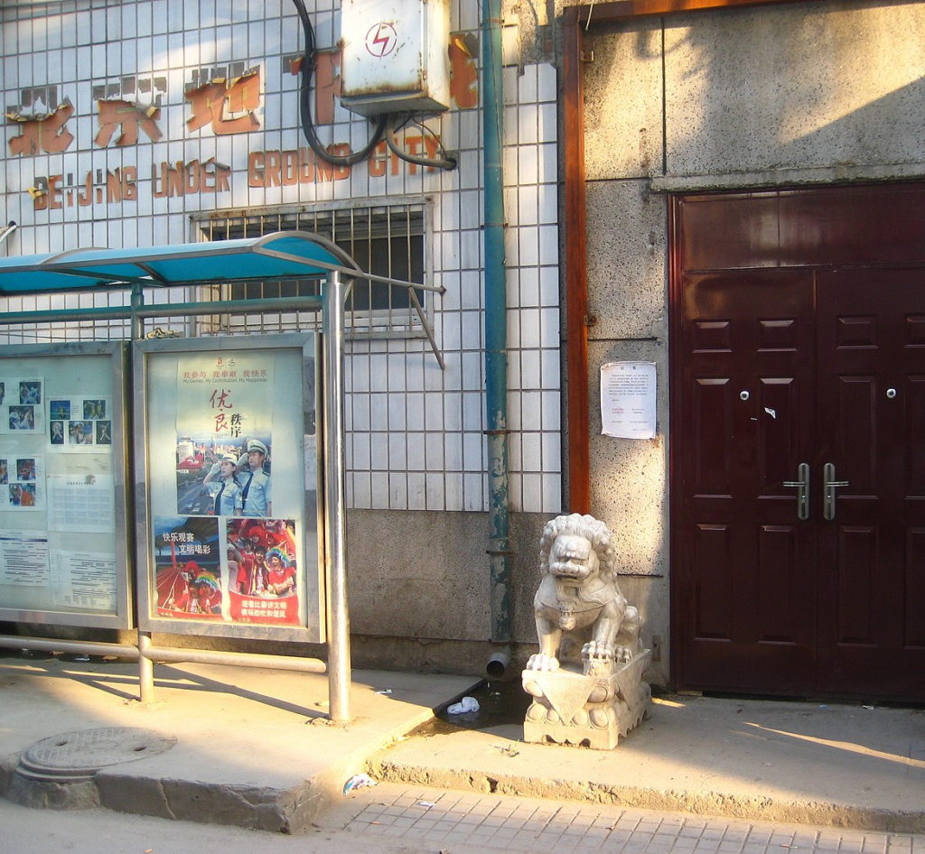
ondergrondse stad

De ingang van de Ondergrondse Stad in Beijing.

3. Wieliczka Zoutmijn, Polen

Op steenworp afstand van de Poolse stad Krakau vind je de Wieliczka Zoutmijn, een van de bekendste attracties van het hele land. Deze 18de eeuwse zoutmijn bestaat uit schitterende kamers en ruimtes vol details en rijkdommen, zoals kroonluchters en beelden. Om er te komen moet je 378 traptreden afdalen en eenmaal beneden nemen gidsen je mee op sleeptouw door dit bijzondere complex.

De Wieliczka zoutmijn ligt in de stad Wieliczka, iets meer dan 9 mijl buiten Krakau.deze ondergrondse zoutstad, een van de grootste toeristische trekpleisters van Polen, is geëvolueerd van een reeks donkere grotten tot een complex labyrint dat nu meer dan 185 indrukwekkende mijl aan galerijen, ongeveer 3000 kamers en negen verdiepingen omvat, waarvan de eerste drie voor het publiek toegankelijk zijn.,

Zodra u de houten trap met 378 treden afdaalt, wordt u begroet met een grote verscheidenheid aan begeleide rondleidingen: als u geïnteresseerd bent in de geschiedenis van de zoutmijn, neem dan de Mijnwerkerstour en krijg inzicht in het moeilijke beroep van een zoutmijnwerker. Als u meer wilt weten over de religieuze aspecten, kunt u ook deelnemen aan de Pelgrimstour met een bezoek aan het zoutbeeld van Johannes Paulus II en een Heilige Mis aan het einde van de tour.,

Ondergrondse Zoutmijn Polen

4. Seattle, Verenigde Staten

De ondergrondse stad van Seattle is ontstaan toen het straatniveau halverwege de 19de eeuw een paar meter werd verhoogd. De voordeuren werden naar boven geplaatst en de benedenverdiepingen gingen dienst doen als een kelder. Tijdens een Underground Tour kun je een kijkje nemen op het vroegere straatniveau en krijg je een goed beeld van hoe de huizen er vroeger hebben uitgezien. Een boeiende tocht die leidt langs historische gevels die elk hun eigen versie van de geschiedenis vertellen.

5.  Réso, Canada

Houd je niet zo van stoffige en slecht verlichte ruimtes? Dan kun je beter koers zetten naar Réso in de Canadese stad Montreal. Dit is een van de meest geavanceerde ondergrondse complexen ter wereld en de perfecte plek om te schuilen op een druilerige dag. Het hypermoderne Réso omvat een reusachtig ondergronds complex, bestaande uit winkelcentra, musea, theaters, schoolgebouwen en hotels. De totale lengte is 33 kilometer en beslaat een gebied van 12 vierkante kilometer.

RÉSO, afgeleid van het Franse woord réseau, wat netwerk betekent, is een van de hoekstenen van Montreal. Dit gigantische doolhof loopt onder de straten van Montreal in en rond het centrum en herbergt een breed scala aan winkels, restaurants, hotels, galeries, zeven metrohaltes, bioscopen, een bibliotheek en zelfs appartementengebouwen.,

de eerste onderling verbonden trajecten werden in 1962 aangelegd met als doel het verkeer te verlichten en een beschut vervoer te bieden, vooral handig tijdens het barre winterseizoen. Sinds de metro van Montreal in 1966 in gebruik is genomen, zijn er meer verbindingen toegevoegd en vandaag de dag bestaat RÉSO uit 20 mijl tunnels met meer dan 120 externe toegangspunten. Naast winkelen kunt u ook de permanente kunstwerken, openbare pleinen en culturele centra bekijken. Als u alle verborgen plekken wilt ontdekken, boek dan een rondleiding en begin te wandelen.,

Reso, Canada
Reso, Canada

6. Shanghai Tunnels, Portland, Verenigde Staten

Portland heeft zijn eigen ondergrondse stad bekend als de Shanghai Tunnels, of de minder voorkomende naam: de Portland Underground. Dit ingewikkelde netwerk zou ooit bestaan uit tunnelgangen die Portland ‘ s Old Town, ook bekend als Chinatown, verbinden met het centrale centrum., Helaas zijn veel van deze ondergrondse ruimtes opgevuld tijdens verschillende openbare werken projecten, maar een paar van hen zijn er nog steeds en open om te verkennen.vroeger waren de kelders van vele bars en hotels via deze tunnels verbonden met de rivier de Willamette, waardoor voorraden van aangemeerde schepen direct naar kelders konden worden verplaatst voor opslag, waardoor regen en zwaar verkeer werden vermeden. Hoewel nog steeds een controversieel onderwerp, het gerucht gaat dat de tunnels zijn ook gebruikt voor de praktijk van “shanghaiing”: het ontvoeren van mensen voor hen om te dienen als matrozen.,maar, vrees niet, vandaag kunt u een veilige wandeling maken en een deel van de Shanghai Tunnels verkennen om een idee te krijgen van het complexe netwerk van tunnels, en een begrip van de zeemijl geschiedenis rond Portland.

7. Coober Pedy, Australië

De Cappadociërs groeven zich in voor de veiligheid, maar in Australië gingen mensen de diepte in voor geld. Opaal, om precies te zijn. In het roestrode landschap rond Coober Pedy, 846 kilometer boven Adelaide, bleek je die edelsteen gewoon uit te kunnen graven.

’s Zomers kan het in deze woestijn wel 45 graden Celsius in de schaduw worden (en succes met schaduw vinden), maar ondergronds hangt de temperatuur het hele jaar rond de 24 graden. Dat was zo comfortabel, dat de opaaldelvers voor zichzelf woonvertrekken uitgroeven (‘dug-outs’), en daarna tunnels, winkels, opslag en zelfs een kapel. Nog steeds woont ongeveer de helft van de 1762 bewoners ondergronds.

Naast opaal draait het ondergrondse dorp natuurlijk ook op toeristen. Geen wonder dat de oorspronkelijke Kokatha-bewoners deze rare zandhoop kupa piti noemden: ‘witte man in een gat in de grond’.

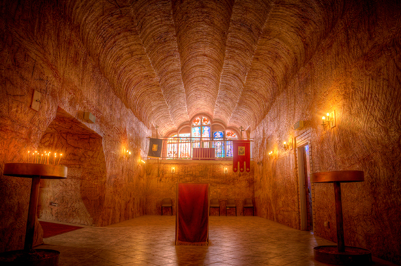
ondergrondse kerk
Ondergrondse servisch-orthodoxe kerk in Coober Pedy.
8. Edinburgh Vaults, Edinburgh, Verenigd Koninkrijk
Onder de straten van de Schotse hoofdstad ligt een donkere en vochtige wereld, daterend uit de 18e eeuw. De Edinburgh Vaults, ook bekend als de South Bridge Vaults, zijn een reeks kamers gevormd binnen de 19 bogen van South Bridge.,geopend in 1788, een periode van grote expansie en groei, de gewelven dateren uit de tijd dat Edinburgh een bijgelovige plaats was. Vandaag de dag stralen ze nog steeds een gevoel van gore en afgrijselijkheid uit. Oorspronkelijk gebouwd om tavernes, schoenmakers, Snijders, smelters en andere handelaren te huisvesten, en om illegale materialen op te slaan, geruchten gaan dat seriemoordenaars Burke en Hare ook verschillende lichamen hier beneden opbergen, die ze verkochten voor medische experimenten., Later, toen de bedrijven verhuisden, werden de gewelven de thuisbasis van de armste zielen van de stad, een achterbuurt compleet met pubs en bordelen verspreid over de natte kamers. Een plek zo grimmig dat elke rosse buurt van vandaag mooi en knus lijkt.duik onder Edinburgh ‘ s sierlijke oppervlak en luister naar de rillende verhalen van de gids over de spoken die nog steeds rondzwerven.,

9. Setenil de las Bodegas, Spanje

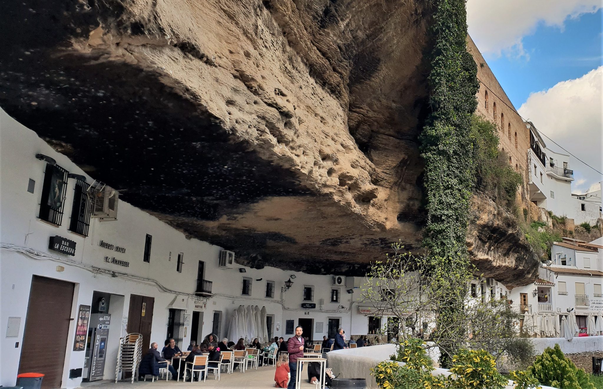
In tegenstelling tot sommige van de andere plaatsen op deze lijst, is Setenil de las Bodegas, een pueblo (kleine stad) in Zuid-Spanje, geen ondergrondse stad op zich, maar ligt het onder massieve overhangen van rotsen. Gelegen langs een smalle rivierkloof die is geërodeerd door de rivier de Rio Trejo, zijn de huizen gebouwd in en onder de muren van de kloof zelf., Mensen vestigden zich hier eigenlijk om praktische redenen: om de zomerhitte en de kou in de winter buiten te houden, bouwden ze alleen de gevel van het huis, terwijl de achterkant door de natuur werd afgeschermd.hoewel het klein is, heeft Setenil de las Bodegas een groot aanbod: bezoek de kleine tapasbars die onder de kloof liggen en proef lokale lekkernijen zoals chorizo, olijfolie, honing, jam en Andalusische wijn. En als je een natuurliefhebber bent, wandel dan langs El Escarpe de Río Trejo, een gebied van natuurlijke diversiteit, of Ruta De los Bandoleros, die vele romantische legendes inspireerde.,
Setenil de las Bodegas on the route of the white villages - Andaluciamia

10. Pilsen Historical Underground, Czech Republic

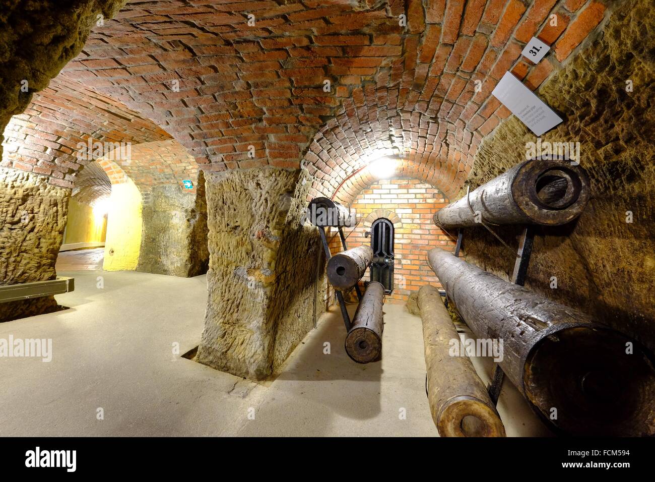
Pilsen hi-res stock photography and images - Alamy

De stad Pilsen, in het westelijke deel van het land, is de thuisbasis van Pilsen Historical Underground, een labyrint van 12.5 mijl lang met gangen, kelders en putten die onder de stad zijn gebouwd straten in de 14e eeuw. Deze kelders dienden ooit als opslagruimte voor voedsel en vaten bier en, sommigen zeggen, als een ontsnappingsroute in geval van een aanval., Volgens de legende is er een schat begraven binnen de keldermuren, hoewel plundering wordt afgeraden.

Neem een rondleiding en verken dit ingenieuze ondergrondse systeem; hoogtepunten zijn onder andere de Ijskelder, de watertoren en de tentoonstelling over middeleeuwse boekbinden. De tour eindigt bij het Brouwerijmuseum, waar u het beroemde lokale Pilsner Urquell bier kunt proeven.,

GERELATEERDE VIDEO'S


{ PETER2011 }
Hoe vind je dit bericht?
Geschreven door peter om 22:22 Stuur door

We komen allemaal uit Afrika, maar wanneer bereikten we andere continenten?

We komen allemaal uit Afrika, maar wanneer bereikten we andere continenten?

Afrika zal uiteindelijk in tweeën splitsen

©Getty Images

We komen allemaal uit Afrika, maar wanneer bereikten we andere continenten?
Heb je je ooit afgevraagd hoe en wanneer mensen zich voor het eerst over de wereld verspreidden, in een tijd voordat er auto's, vliegtuigen en boten bestonden?

Van de woestijnen van Afrika tot de ijzige vlaktes van Noord-Amerika, de reis van onze voorouders is er een van avontuur, overleven en ontdekken. Vandaag de dag zijn wetenschappers nog steeds bezig om de puzzel van de menselijke migratie in elkaar te passen. Ze gebruiken oude artefacten, genetische gegevens en zelfs voetafdrukken om te achterhalen waar we vandaan kwamen en hoe we elke uithoek van de aarde bereikten.

Benieuwd naar de ongelooflijke weg die onze voorouders hebben afgelegd? Klik verder om de fascinerende geschiedenis te ontdekken van hoe mensen de wereldburgers werden die we nu zijn.

Waar het allemaal begon

©Shutterstock

Waar het allemaal begon
Homo sapiens evolueerde ongeveer 300.000 jaar geleden voor het eerst in Afrika, waardoor het continent de geboorteplaats werd van de moderne mens.

Meerdere oorsprongen

©Shutterstock

Meerdere oorsprongen
Het idee dat moderne mensen gelijktijdig in meerdere regio's, zoals Europa en Azië, evolueerden, was ooit een populaire theorie die de multiregionale of candelabra-hypothese werd genoemd.

Wat onderzoek zegt

©Getty Images

Wat onderzoek zegt
Tegenwoordig wijzen wetenschappers, waaronder paleoantropoloog Michael Petraglia, deze theorie grotendeels af.

De 'Out of Africa'-theorie

©Shutterstock

De 'Out of Africa'-theorie
De meeste wetenschappers denken dat Homo sapiens uit Afrika kwamen en zich daarna over de wereld verspreidde, waarbij ze andere hominiden vervingen of zich ermee mengden. Zoals Petraglia zegt: "Alle bewijzen wijzen naar de oorsprong en beweging van Homo sapiens uit Afrika".

Wanneer verlieten mensen voor het eerst Afrika?

©Shutterstock

Wanneer verlieten mensen voor het eerst Afrika?
Ongeveer 200.000 jaar geleden begonnen Homo sapiens hun migratie uit Afrika, eerst naar nabije gebieden, en hun wereldwijde verspreiding gebeurde in de daaropvolgende duizenden jaren.

Oversteekpunt

©Shutterstock

Oversteekpunt
Een van de eerste routes uit Afrika liep misschien via het Sinaï-schiereiland, een nu droge regio tussen Egypte, Jordanië en Israël. Toen de eerste mensen daar trokken richting het oostelijke Middellandse Zeegebied, was het veel groener dan nu.

Lopend

©Shutterstock

Lopend
Een theorie zegt dat de eerste mensen via een landbrug van Afrika naar Arabië liepen, via de Bab el-Mandeb (of Bab al-Mandab) zeestraat, die ligt tussen de Hoorn van Afrika en het zuidelijke puntje van het Arabisch Schiereiland.

Met een peddel over

©Shutterstock

Met een peddel over
Maar een studie uit 2006 sprak het idee van een landbrug tegen en stelde dat de eerste mensen misschien peddelend of drijvend de oversteek maakten.

Naar Azië

©Shutterstoc

Naar Azië
Meer dan 100.000 jaar geleden verspreidden Homo sapiens zich naar Azië. Er zijn aanwijzingen dat ze de kustlijnen volgden en daarna langzaam het binnenland introkken.

Rondtrekken en mengen

©Getty Images

Rondtrekken en mengen
Zo’n 54.000 tot 44.000 jaar geleden kwamen moderne mensen de Denisovans tegen, een andere oude mensensoort, en vermengden zich met hen.

Denisova-erfenis

©Getty Images

Denisova-erfenis
Daardoor zeggen onderzoekers dat er nog steeds sporen van Denisova-DNA te vinden zijn in de genen van sommige Aziatische bevolkingsgroepen van vandaag.

Aankomst in Europa

©Shutterstock

Aankomst in Europa
De eerste bewijzen van Homo sapiens in Europa zijn zo’n 210.000 jaar oud, met fossielen gevonden in de Apidima-grot in Zuid-Griekenland.

Eerste golf

©Shutterstock

Eerste golf
Maar als deze datering klopt, denkt Martin Richards, evolutionair geneticus aan de University of Huddersfield in Engeland, dat het misschien gaat om een vroege golf migrerende Homo sapiens die uitstierf of zich terugtrok tijdens een ijstijd (wanneer gletsjers zich uitbreiden).

Dichte verwanten

©Getty Images

Dichte verwanten
Na deze periode denken wetenschappers dat Homo sapiens zich blijvend vestigde in Europa, zo’n 50.000 tot 60.000 jaar geleden. In die tijd vermengden ze zich met de Neanderthalers, een andere oude mensensoort, en vervingen hen uiteindelijk.

Zuidwaarts trekken

©Getty Images

Zuidwaarts trekken
DNA-bewijs laat zien dat moderne mensen zo’n 60.000 jaar geleden Zuidoost-Azië bereikten.

Aankomst in Oceanië

©Shutterstock

Aankomst in Oceanië
In die tijd waren grote delen van Zuidoost-Azië en Australië met elkaar verbonden door land, en verspreidden mensen zich over deze gebieden.

Door de Stille Oceaan

©Getty Images

Door de Stille Oceaan
Zo’n 50.000 jaar geleden bereikten moderne mensen Nieuw-Guinea, wat blijkt uit archeologische vondsten. Van daaruit verspreidden ze zich in meerdere migratiegolven over de eilanden van de Stille Oceaan, waarbij ze zich aanpasten aan de unieke omstandigheden van elke eilandengroep.

De Lapita-expansie

©Getty Images

De Lapita-expansie
Door het bestuderen van Lapita-aardewerk hebben wetenschappers vroege menselijke aanwezigheid in Nieuw-Guinea en omliggende gebieden kunnen traceren. Volgens UNESCO markeren Lapita-locaties de eerste menselijke kolonisatie van Tonga, zo’n 2.800 jaar geleden.

Polynesische expansie

©Getty Images

Polynesische expansie
Vergelijkbare locaties in de Bismarck-archipel, de Salomonseilanden, Vanuatu, Nieuw-Caledonië, Fiji en Samoa laten grote culturele veranderingen zien in de westelijke Stille Oceaan, zo’n 3.000 jaar geleden. Deze veranderingen worden gekoppeld aan de migratie van Austronesisch sprekende volkeren van Zuidoost-Azië naar de verder gelegen eilanden van Oceanië.

Polynesische zeereizen

©Shutterstock

Polynesische zeereizen
Zo’n 1.500 jaar geleden begonnen de Polynesiërs aan grote zeereizen over de Stille Oceaan en bereikten afgelegen eilanden zoals Hawaï, Paaseiland en Nieuw-Zeeland.

Op weg naar Noord-Amerika

©Getty Images

Op weg naar Noord-Amerika
De traditionele theorie over menselijke migratie naar Noord-Amerika zegt dat vroege Homo sapiens zo’n 13.000 jaar geleden vanuit Siberië een landbrug overstaken, genaamd Bering (of Beringia).

Oorspronkelijke bewoners

©Getty Images

Oorspronkelijke bewoners
Nomadische inheemse groepen uit Siberië, zoals de Tsjoektsjen (op de foto), zijn de dichtstbijzijnde levende link met de vroege kolonisten in de regio. De Tsjoektsjen worden ook gezien als de nauwste Aziatische voorouders van de inheemse volkeren in Amerika.

Eerste Noord-Amerikanen

©Getty Images

Eerste Noord-Amerikanen
Archeologen hebben bewijs gevonden van pre-Clovis nederzettingen en zelfs oudere menselijke voetafdrukken in New Mexico. Dit suggereert dat de eerste Noord-Amerikanen via deze route—en mogelijk langs de Pacifische kust—al minstens 23.000 jaar geleden aankwamen.

Pre-Clovis

©Getty Images

Pre-Clovis
Dit is ouder dan de Clovis-mensen, waarvan men denkt dat ze Amerika bevolkten tussen 10.000 en 9.000 v.Chr.

Zuid-Amerika

©Getty Images

Zuid-Amerika
Homo sapiens bereikte Zuid-Amerika zo’n 15.000 jaar geleden. Archeologische sites zoals Monte Verde in Chili bewijzen menselijke nederzetting van ongeveer 14.550 jaar geleden.

Ver terug

©Getty Images

Ver terug
Hoewel er discussie is over de tijdlijn van de vroege menselijke aankomst in Zuid-Amerika, wijst bewijs van meerdere sites erop dat Homo sapiens veel eerder arriveerde dan eerder werd gedacht.

Oude kolonisten

©Shutterstock

Oude kolonisten
De Uros zijn een van de oudste inheemse groepen van Peru, met wortels die teruggaan tot ongeveer 3.700 jaar geleden, toen de centrale Andes voor het eerst werden bewoond.

Genetische verbinding

©Shutterstock

Genetische verbinding
Volgens geneticus José Raúl Sandoval, die hun DNA heeft bestudeerd, "zijn de overgrote meerderheid van de inheemse Zuid-Amerikanen genetisch verwant, omdat ze afstammen van dezelfde groep voorouders die oorspronkelijk op het continent aankwam", ongeacht de route die ze namen.

Laatste stop: Antarctica

©Getty Images

Laatste stop: Antarctica
Mensen bereikten Antarctica later dan elk ander continent. Hoewel de landing van de Amerikaan John Davis in 1821 officieel als de eerste wordt geregistreerd, zijn er aanwijzingen voor eerdere bezoeken.

Nog niet zeker

©Getty Images

Nog niet zeker
Zelfs de bewering dat de Noren Henrik Bull en Carsten Borchgrevink (op de foto) eind 1800 als eersten voet aan wal zetten, wordt betwist.

Een andere theorie

©Getty Images

Een andere theorie
Sommige studies suggereren dat de Māori uit Nieuw-Zeeland mogelijk al in de 7e eeuw naar Antarctica zeilden, hoewel dit idee niet breed wordt geaccepteerd door historici.

Bronnen:

  • (Live Science)
  • (Britannica)
  • (UNESCO)
  • (Big Think)

{ Stars Insider }

Hoe vind je dit bericht?
Geschreven door peter om 14:43 Stuur door

Long-lost ancient Egyptian technology rewrites the dawn of civilization

Long-lost ancient Egyptian technology rewrites the dawn of civilization

A tiny copper-alloy tool long overlooked in a museum collection is reshaping what archaeologists know about the origins of human engineering. 

Researchers said the artefact shows ancient Egyptians were using a mechanically sophisticated rotary bow drill more than 5,300 years ago.

The object, cataloged as 1924.948 A in the University of Cambridge's Museum of Archaeology and Anthropology, has now been identified as the earliest known metal drill. 

The finding pushes back the timeline for advanced drilling technology by more than two millennia, forcing scholars to rethink when complex mechanical tools first emerged.

First excavated a century ago from a cemetery at Badari in Upper Egypt, the tool shows wear consistent with rotary drilling.

The tool contained arsenic and nickel, with notable amounts of lead and silver, suggesting deliberate engineering choices and pointing to early material trade or shared technical knowledge across the ancient Mediterranean.

Lead author Dr Martin Odle from Newcastle University said: 'This re-analysis has provided strong evidence that this object was used as a bow drill, which would have produced a faster, more controlled drilling action than simply pushing or twisting an awl-like tool by hand. 

'This suggests that Egyptian craftspeople mastered reliable rotary drilling more than two millennia before some of the best-preserved drill sets.'

Researchers said the artefact shows ancient Egyptians were using a mechanically sophisticated rotary bow drill more than 5,300 years ago, far earlier than previously believed

Researchers said the artefact shows ancient Egyptians were using a mechanically sophisticated rotary bow drill more than 5,300 years ago, far earlier than previously believed

When archaeologist Guy Brunton first documented the object in the 1920s, he described it simply as a small copper awl with leather wrapped around it. 

The brief classification led the artefact to be largely overlooked for nearly a century. 

Microscopic analysis revealed wear patterns inconsistent with simple puncturing or scraping. Fine striations, rounded edges, and a subtle curve at the tip indicate the tool was repeatedly rotated, pointing to sustained rotary drilling rather than basic piercing.

Researchers also found six coils of extremely fragile leather thong still wrapped around the shaft, which they said provides direct evidence of a bow drill system. 

In such a mechanism, a string wound around the drill shaft is driven back and forth by a bow, rapidly spinning the tool to cut into material.

'Behind Egypt's famous stone monuments and jewelry were practical, everyday technologies that rarely survive archaeologically,' Odle said. 

'The drill was one of the most important tools, enabling woodworking, bead production, and furniture making. 

Bow-powered drills appeared frequently in New Kingdom tomb scenes, and several complete examples from that era survive. 

Pictured is the Khufu Pyramid, also known as the Great Pyramid, in Giza Pyramid Complex, dating to about 1,000 years after the ancient drill was crafted

Pictured is the Khufu Pyramid, also known as the Great Pyramid, in Giza Pyramid Complex, dating to about 1,000 years after the ancient drill was crafted

The Badari discovery is far older, dating to Naqada IID, and suggests Egyptians had perfected fast, controlled rotary drilling nearly two millennia before those later depictions. 

Naqada IID, a late Predynastic period around 3300 to 3200 BC, saw the inception of kingship, writing, and organized religion, which would become the basis of the classical Egyptian civilization.

A study released in December revealed a discovery that changes what we know about ancient Egypt.

article image

The discovery rewrites the timeline of Egypt's early dynasties, placing the rise of the New Kingdom nearly a century later than previously thought.

The New Kingdom, which lasted from 1550 to 1070 BCE, was Egypt's peak of power, wealth, and territorial expansion, the era of famous rulers like Tutankhamun.

It began with the 18th Dynasty, founded by Pharaoh Ahmose I, who reunited Egypt and expelled the Hyksos invaders, restoring central authority after a period of fragmentation.

Now, scientists have confirmed that the massive Santorini (Thera) volcanic eruption occurred before the reign of Ahmose, meaning the 18th Dynasty, and the New Kingdom itself, rose later than previously believed.

Until now, historians had often assumed the eruption might have coincided with the early New Kingdom, and some researchers even tried to link it to specific pharaohs, including Hatshepsut, Thutmose III or Ahmose I.

The breakthrough comes from radiocarbon dating of Egyptian artifacts from the 17th and early 18th Dynasties.

Researchers examined a mudbrick stamped with Ahmose's name, a linen burial cloth, and wooden funerary figures called shabtis, all of which were directly tied to known pharaohs and their temples.

Because these objects are anchored to specific historical contexts, their ages provide a reliable snapshot of the period. 

The study shows that the eruption predates these artifacts, reshaping how historians understand the rise of Egypt's most powerful period.

RELATED VIDEOS

{ https://www.dailymail.co.uk/sciencetech/index.html }

Hoe vind je dit bericht?
Geschreven door peter om 21:16 Stuur door

A 3,000-year-old structure mentioned in the Bible has been identified

A 3,000-year-old structure mentioned in the Bible has been identified

Story by Barrie Davenport
Researchers say the ancient moat reshapes what we know about Jerusalem’s defenses during the First Temple period.

©Image license via Planet Sage/ChatGPT

Researchers say the ancient moat reshapes what we know about Jerusalem’s defenses during the First Temple period.
A massive stone-cut feature hidden beneath Jerusalem’s City of David is reshaping how archaeologists understand the ancient city’s defenses. Long debated in scholarly circles, the structure matches descriptions of a deep moat referenced in biblical texts and dates to around 3,000 years ago, during the First Temple period.

New excavations and careful reanalysis suggest this wasn’t a minor trench, but a major engineered barrier designed to protect the city’s core. The finding helps clarify how Jerusalem was fortified — and how its leaders used landscape and construction to control movement, access, and security.

1. The Structure Was Found in the City of David

©Image license via Canva

1. The Structure Was Found in the City of David
The discovery was made in the City of David, an area just south of Jerusalem’s Old City that has been excavated for decades. Archaeologists uncovered a deep, rock-cut channel separating the city’s residential areas from its political and religious center.

This feature had been partially known, but its true scale and purpose were unclear. New excavations revealed its depth, width, and strategic placement, pointing to a deliberate defensive role rather than simple drainage or quarrying.

7. The Excavation Helps Reconstruct Daily Life in Ancient Jerusalem

©Image license via Wikimedia Commons/УчаÑтник

2. It Dates Back Roughly 3,000 Years
Based on pottery, construction style, and stratigraphy, researchers date the structure to around the 10th century BCE. This places it firmly in the era traditionally associated with Jerusalem’s early monarchy and the First Temple period.

That timing is significant because it aligns with written descriptions of fortified Jerusalem during this era. While archaeology doesn’t confirm narratives outright, matching dates strengthen the case that texts were describing real, large-scale infrastructure.

3. The Moat Was Carved Directly Into Bedrock

©Image license via Canva

3. The Moat Was Carved Directly Into Bedrock
Unlike later defensive walls built above ground, this structure was carved directly into solid bedrock. That would have required extensive labor, planning, and centralized authority.

Such effort suggests the city’s leaders viewed defense as a top priority. Carving stone rather than piling earth also made the barrier harder to cross, harder to fill in, and more permanent than simpler fortifications.

4. It Functioned as a Defensive Barrier

©Image license via Canva

4. It Functioned as a Defensive Barrier
Archaeologists now believe the channel acted as a moat, physically separating the city’s core from surrounding areas. Anyone approaching the administrative or royal center would have had to cross this obstacle.

This setup would have slowed attackers and controlled access points, forcing movement into narrow, defensible routes. It reflects sophisticated urban planning rather than ad-hoc defense.

6. The Discovery Was Made by a Medieval Literature Expert

©Image license via Canva

5. Biblical Texts May Reference This Feature
Several ancient texts describe a defensive divide protecting Jerusalem’s most important structures. Scholars long debated whether those passages were symbolic or literal.

The newly analyzed structure fits those descriptions in size, placement, and function. Researchers stress this doesn’t “prove” texts, but it does show they may preserve accurate memories of real city features.

6. Earlier Excavations Missed Its Full Purpose

©Image license via Wikimedia Commons/Oren Rozen

6. Earlier Excavations Missed Its Full Purpose
Parts of the channel were uncovered in earlier digs, but they were often interpreted as quarries or incomplete construction projects. Without full exposure, its defensive role wasn’t obvious.

Only by connecting multiple excavation zones and reexamining earlier assumptions did archaeologists recognize the structure as a single, continuous system built with a clear strategic goal.

7. The Moat Helped Control Movement Inside the City

©Image license via Wikimedia Commons/עומר מרקובסקי

7. The Moat Helped Control Movement Inside the City
Beyond defense, the moat likely played a role in controlling who could access elite or sacred areas. Gates or bridges would have funneled movement into monitored points.

This kind of internal boundary reflects social and political hierarchy, separating everyday residential life from centers of power and worship within the city.

2. The Ark Was Central to Ancient Israel’s Worship and Identity

©Image license via Picryl

8. The Discovery Changes Views of Early Jerusalem
For years, scholars debated how large and organized Jerusalem was during this period. Some argued it lacked the resources for major infrastructure.

A project of this scale suggests a city capable of mobilizing labor, engineering expertise, and long-term planning — pointing to a more complex and powerful early Jerusalem than some models assumed.

5. The Holy Sepulchre’s Location Fits Ancient Geography

©Image license via Flickr/BORIS G

9. Defensive Design Was Integrated With the Landscape
Rather than imposing walls alone, city planners used natural ridges and valleys, enhancing them with carved features like this moat.

This approach reduced construction needs while maximizing defensive advantage. It shows a deep understanding of terrain and how to adapt it for urban protection.

10. Not Every Discovery Comes From Something New

©Image license via Wikimedia Commons/Daniel Ventura

10. Not Every Discovery Comes From Something New
This find underscores how archaeology often advances through reinterpretation, not just new digs. Features once labeled mundane can gain new meaning with fresh context.

By revisiting earlier finds with updated methods and broader excavation data, researchers can uncover insights that were hiding in plain sight.

11. The Moat Offers a Clearer Picture of the Ancient City

©Image license via Canva

11. The Moat Offers a Clearer Picture of the Ancient City
Taken together, the evidence paints a picture of Jerusalem as a carefully planned, defensively minded city 3,000 years ago. The moat wasn’t an afterthought — it was central to how the city functioned.

As excavations continue, researchers expect the structure to help refine timelines, urban layout, and how ancient Jerusalem balanced security, governance, and daily life.

 { Planet Sage }

Hoe vind je dit bericht?
Geschreven door peter om 17:55 Stuur door

Geheimzinnige, onopgeloste archeologische mysteries

Geheimzinnige, onopgeloste archeologische mysteries

We bekijken hier de tien grootste mysteries

©The Daily Digest

We bekijken hier de tien grootste mysteries
Heb je ooit naar de ruïnes van een oude beschaving gekeken en jezelf afgevraagd hoe zo'n ontzagwekkende plek is gemaakt door degenen die ons zijn voorgegaan? Als dat zo is, dan ben je niet alleen, onze wereld kent nog altijd veel mysteries.

Ruïnes die een totaal raadsel blijven

©The Daily Digest

Ruïnes die een totaal raadsel blijven
Sommige van de bekendste archeologische vindplaatsen over de hele wereld zitten nog steeds vol geheimen, aldus National Geographic Expeditions, die tien van de bekendste plaatsen opsomde die nog steeds een compleet raadsel zijn voor archeologen.

1. Machu Picchu in Peru

©The Daily Digest

1. Machu Picchu in Peru
Machu Picchu is waarschijnlijk de bekendste stad van de Inca's, maar we weten eigenlijk maar weinig over hoe hij tot stand is gekomen. Wel weten we dat hij gebouwd is door de Incaleider Pachacutec in de 15e eeuw, maar niet waarom hij gebouwd is.

Populaire theorieën over Machu Picchu

©The Daily Digest

Foto: Christophe Meneboeuf - eigen werk / Wikimedia

Populaire theorieën over Machu Picchu
Een populaire theorie is dat de Inca's Machu Picchu bouwden als een hooggelegen toevluchtsoord voor hun vorsten. Maar kennelijk bouwden ze de tempels, baden en plaatsen zonder de hulp van een wiel, metalen gereedschappen of mortel. Indrukwekkend, nietwaar?

Waarom viel Machu Picchu?

©The Daily Digest

Foto: Diego Delso, CC BY-SA 4.0 / Wikimedia

Waarom viel Machu Picchu?
Machu Picchu werd om mysterieuze redenen verlaten en we weten nog steeds niet waarom. De Encyclopaedia Britannica merkte op dat water een rol kan hebben gespeeld, terwijl andere theorieën suggereren dat de Spaanse conquistadores de oorzaak zijn.

2. Skara Brae op de Orkneyeilanden in Schotland

©The Daily Digest

2. Skara Brae op de Orkneyeilanden in Schotland
Dit archeologische mysterie ken je waarschijnlijk niet, maar is afkomstig van de Britse eilanden. Skara Brae werd net als Machu Picchu verlaten en we weten nog steeds niet waarom. Maar wat is dit verbluffend bewaard gebleven oude dorp?

Een goed bewaard gebleven neolithisch dorp

©The Daily Digest

Een goed bewaard gebleven neolithisch dorp
Skara Brae was een neolithische stenen dorp van negen huizen op de Orkneyeilanden bij Schotland. We beschikken over resten van de levendige levensstijl van de dorpelingen, zoals hun toiletten en ladekasten. Maar de locatie is gehuld in mysterie.

3. De Grote Sfinx van Gizeh in Egypte

©The Daily Digest

3. De Grote Sfinx van Gizeh in Egypte
De Grote Sfinx van Gizeh is het afgelopen decennium het middelpunt geweest van veel controverse vanwege de bewering dat hij veel ouder is dan archeologen eerder dachten. De vraag is wie de sfinx heeft gebouwd en waarom.

Hoe zit het met de Sfinx?

©The Daily Digest

Hoe zit het met de Sfinx?
Kimberly McGlynn van de North Dakota State University schreef in een artikel over de leeftijd van de Sfinx dat sommige archeologen stellen dat de Sfinx ongeveer 4500 jaar oud is en werd gebouwd tijdens het bewind van farao Chefren. Anderen zijn het daar echter niet mee eens.

Hoe oud is de Sfinx eigenlijk?

©The Daily Digest

Hoe oud is de Sfinx eigenlijk?
Egyptologen als John Anthony West en dr. Robert Schoch waren het erover eens dat watererosie aan de voet van de Sfinx een deel van het bouwwerk kon dateren in een andere en veel oudere tijdspanne tussen 7000 en 10.000 jaar oud.

4. Angkor in Cambodia

©The Daily Digest

4. Angkor in Cambodia
Angkor is het grootste mysterie van Cambodja. Maar in tegenstelling tot de anderen op deze lijst weten we wel veel over de ruïnes van de stad. De stad werd gesticht door Jayavarman II van het Khmer-rijk en werd het grootste stedelijke complex van de pre-industriële wereld.

Het watersysteem van Angkor

©The Daily Digest

Foto: Diego Delso, CC BY-SA 3.0 / Wikimedia

Het watersysteem van Angkor
De stad is een uitgestrekt doolhof van straten en is voorzien van een ingewikkeld watersysteem volgens de technieken van de oudheid. Helaas heeft het verbazingwekkende vermogen van Angkor om water op te slaan de stad niet kunnen redden van de ondergang, en we weten nog steeds niet precies waarom.

5. Paaseiland in Chili

©The Daily Digest

5. Paaseiland in Chili
Paaseiland is een van die mysterieuze archeologische vindplaatsen die archeologen nog steeds voor raadsels stellen en dat is heel logisch. Hoe hebben de Polynesiërs die op het eiland woonden in vredesnaam zulke enorm standbeelden gebouwd? En nog belangrijker, waarom?

©The Daily DigestMeer dan 900 megastandbeelden op het eiland

©The Daily Digest

Meer dan 900 megastandbeelden op het eiland
National Geographic schreef dat de meer dan 900 beelden op het eiland waarschijnlijk zonder hulp van wielen of grote dieren zijn gebouwd. Onderzoekers begrijpen hun doel nog steeds niet helemaal, maar ze hebben wel theorieën.

6. De tempels van Ġgantija in Malta

©The Daily DigestFoto: Fritz

Photography - eigen werk, CC BY-SA 4.0 / Wikimedia

6. De tempels van Ġgantija in Malta
Malta lijkt je misschien niet direct een plek waar zich het grootste archeologische mysterie ter wereld bevindt, maar toch zou dat wel eens zo kunnen zijn vanwege de tempels van Ġgantija. Ze bevinden zich op het eiland Gozo en verbijsteren ons al eeuwenlang.

Een van de oude bouwwerken ter wereld

©The Daily Digest

Foto: Stijndon - eigen werk, CC BY-SA 3.0 / Wikimedia

Een van de oude bouwwerken ter wereld
Verschillende delen van de tempel werden al in 3600 v. Chr. en in 2900 v. Chr. gebouwd. Het is ook een van de vroegste vrijstaande bouwwerken ter wereld die archeologen kennen volgens Heritage Daily.

Wie werd er vereerd in de tempel?

©The Daily Digest

Foto: Bs0u10e01 - eigen werk, CC BY-SA 4.0 / Wikimedia

Wie werd er vereerd in de tempel?
Het gebied werd jarenlang bewoond en we zijn er vrij zeker van dat het een tempel was waar onze voorouders naartoe gingen om te vereren. Maar wie ze vereerden en hoe ze dat enorme ding bouwden is vandaag de dag nog steeds grotendeels een mysterie.

7. Tikal in Guatemala

©The Daily Digest

7. Tikal in Guatemala
Tikal was een machtige Mayastad die floreerde in 300 na Christus. Er woonden ooit ongeveer 60.000 mensen en de stad besloeg een oppervlakte van 47 vierkante kilometer. De stad is bedekt met veel monumenten, maar er is geen enkele verklaring voor het verlaten ervan.

De stèles van Tikal

©The Daily Digest

De stèles van Tikal
National Geographic ontdekte dat we veel te weten zijn gekomen door het ontcijferen van de stèles (monolieten) op de locatie. Maar de hiërogliefen vertellen ons niet of het droogte, ziekte of oorlog was die de inwoners dwong de stad te verlaten.

8. De Nazcalijnen in Peru

©The Daily Digest

Foto: Diego Delso, CC BY-SA 4.0 / Wikimedia

8. De Nazcalijnen in Peru
De Nazcalijnen behoren zonder twijfel tot de grootste mysteries ter wereld. Deze lijnen dateren uit 200 tot 500 na Christus en vormen ingewikkelde afbeeldingen die vanuit de lucht gezien kunnen worden, maar we hebben geen idee hoe de makers ervan dat zo fantastisch hebben gedaan.

De mythe van de Nazcalijnen

©The Daily Digest

Foto: Diego Delso, CC BY-SA 4.0 / Wikimedia

De mythe van de Nazcalijnen
“Het aantal Nazcalijnen dat in de grond is gekerfd loopt in de duizenden en ze verbeelden wezens uit zowel de natuurlijke wereld als de menselijke verbeelding”, schreef Live Science en voegde eraan toe dat er ongeveer 1500 glyphen zichtbaar zijn op de grond.

9. Het Terracottaleger van Qin Shi Huangdi in China

©The Daily Digest

9. Het Terracottaleger van Qin Shi Huangdi in China
Het 8000 soldaten tellende terracottaleger van de eerste Chinese keizer Qin Shi Huangdi is een bijzondere historische rariteit. Het mysterie achter dit archeologische wonder is niet hoe ze zijn gemaakt, maar waarom? Wat beschermden deze soldaten?

10. Chichén Itzá in Mexico

©The Daily Digest

10. Chichén Itzá in Mexico
Chichén Itzá is nog zo'n Maya wonder dat baadt in mysterie. Het werd gebouwd in de 6e eeuw en telde volgens National Geographic op het hoogtepunt 50.000 inwoners. Vandaag de dag is het nog steeds een mysterie omdat we niet weten wat er met de inwoners is gebeurd.

©The Daily Digest

"Hoe is het afgelopen met deze bijzondere cultuur?"

"Hoe is het afgelopen met deze bijzondere cultuur? Misschien was het interne oorlog die haar ondergang inluidde, overbevolking, ontbossing of droogte. We zullen het misschien nooit weten", zegt National Geographic.

GERELATEERDE VIDEO'S

 {  The Daily Digest }

Hoe vind je dit bericht?
Geschreven door peter om 00:00 Stuur door

Long-lost rivers of the Bible found in satellite images point to the Garden of Eden

Long-lost rivers of the Bible found in satellite images point to the Garden of Eden

For centuries, the Garden of Eden has been a symbol of paradise in the Bible,  a lush, perfect world where Adam and Eve once walked. 

Many have dismissed it as a myth, but now, resurfaced satellite images have suggested that the story may have a very real geographical basis.

A series of orbital scans has revealed an ancient, now-dry riverbed in Saudi Arabia that some scholars believe aligns with the biblical description of Eden's main river, the Pishon.

The Book of Genesis describes Eden as a paradise watered by a single river that split into four: Pishon, Gihon, Tigris, and Euphrates. 

While the Tigris and Euphrates are well-known rivers in modern-day Iraq, the Pishon and Gihon have long been lost to history, until now.

The dry riverbed, called Wadi al-Batin, stretches from the western highlands of Hejaz near Medina northeast to the northern Persian Gulf near Kuwait. 

Its winding course corresponds closely with the biblical description of the Pishon, which Genesis states 'compasseth the whole land of Havilah, where there is gold; and the gold of that land is good: there is bdellium and the onyx stone.' 

Modern satellite imagery spotted Wadi al-Batin's delta near the Gulf, with dunes and depressions marking the river's former grandeur.

Complementing this, Iran's Karun River, a twisting waterway flowing through the Zagros Mountains, may correspond to the Gihon. The Hebrew word 'sabab,' meaning to circle or twist, aptly describes the Karun's meanders. 

Many have dismissed the Garden of Eden as a myth, but now, resurfaced satellite images have suggested that the story may have a very real geographical basis

Many have dismissed the Garden of Eden as a myth, but now, resurfaced satellite images have suggested that the story may have a very real geographical basis

The Garden of Eden (Pictured) was described in the Book of Genesis as a paradise where the first humans, Adam and Eve, once walked before committing the first sin

The Garden of Eden (Pictured) was described in the Book of Genesis as a paradise where the first humans, Adam and Eve, once walked before committing the first sin

Historically, the river ran through the Kassite territory, identified by some scholars as the land of Cush mentioned in Genesis.

The discovery of Wadi al-Batin as a potential Eden riverbed dates back to the early 1990s, when Boston University geologist Farouk El-Baz analyzed radar images from NASA's Space Shuttle Endeavor. 

However, the images were revisited on Patheos this month, reigniting attention to what had been lost for thousands of years.

The data revealed a fossilized river up to three miles wide, active during a wetter Holocene era before drying between 2000 and 3500 BC due to climate shifts.

'These satellite images give us a window into landscapes that have vanished over millennia,' said Dr El-Baz. 

'We can now trace rivers that once shaped human settlement and perhaps even inspired ancient biblical narratives.'

The alignment of these rivers with biblical text is striking, as together with the Tigris and Euphrates, Wadi al-Batin and the Karun would have converged into the Persian Gulf, forming a fertile cradle of civilization. 

A series of orbital scans has revealed an ancient, now-dry riverbed in Saudi Arabia that some scholars believe aligns with the biblical description of Eden's main river, the Pishon

A series of orbital scans has revealed an ancient, now-dry riverbed in Saudi Arabia that some scholars believe aligns with the biblical description of Eden's main river, the Pishon

Complementing this, Iran's Karun River, a twisting waterway flowing through the Zagros Mountains, may correspond to the Gihon

Complementing this, Iran's Karun River, a twisting waterway flowing through the Zagros Mountains, may correspond to the Gihon

James A Sauer, a biblical archaeologist who analyzed the satellite data, said that the dry riverbed’s features best match the biblical description of the Pishon, though he stops short of declaring this proof of Eden itself.

However, according to archaeologist Juris Zarins, satellite imagery showing ancient riverbeds near the Persian Gulf corresponds with descriptions from Genesis, suggesting the Eden narrative may reflect real ancient geography even if its spiritual elements remain interpretive. 

Environmental data has also supported this theory, showing Arabia's arid transformation after the last Ice Age and rising sea levels that may have submerged parts of Eden's delta.

Not all scholars agree, however. Some argue the land of Cush may refer to regions in Africa, connecting the Gihon to the Nile instead. 

Others cautioned that biblical texts blend spiritual allegory with historical memory, making precise mapping speculative.

Despite these debates, the discovery has reignited interest in the geography of Genesis. 

Satellite maps of the Fertile Crescent, including Wadi al-Batin's path, reveal a landscape that once supported early human settlements. 

This area is where the Tigris and Euphrates rivers merge to form the Shatt al-Arab, which then flows into the Persian Gulf

This area is where the Tigris and Euphrates rivers merge to form the Shatt al-Arab, which then flows into the Persian Gulf

The ancient rivers' courses align with archaeological evidence of early farming communities and trade networks, providing a tantalizing glimpse of a pre-flood world described in biblical texts.

There have been many theories about where the Garden of Eden was located, with a recent suggestion putting it in Africa.

Mahmood Jawaid, a chemical engineer based in Texas, argued Eden was actually in Bahir Dar, a fertile region in northwestern Ethiopia near the southern end of Lake Tana, where the Blue Nile begins.

Jawaid based his research on a careful reading of both the Bible and the Quran, analyzing descriptions of Adam and Eve, the rivers and the garden itself.

The 2025 study, which has not been peer-reviewed, noted the Blue Nile could correspond to the Biblical Gihon, and Lake Tana's outflows divide into multiple waterways, potentially forming the four rivers described in Genesis.

Early human evolution also played a role in this theory, proposing that Adam may have evolved from Homo habilis or a late form of Australopithecus in the East African Rift Valley near Olduvai Gorge, a region considered a cradle of humanity.

From there, Adam and Eve could have been 'placed' in the highlands of Bahir Dar, a paradise at a higher elevation, before descending, what the Quran describes as 'habata,' to settle in the Rift Valley.

This is because the region sits about 6,000 feet above sea level, boasting lush vegetation, abundant wildlife and the flowing Blue Nile, features that align with both the Biblical description of Eden's rivers and the Quranic concept of a garden on Earth.

RELATED VIDEOS

The Garden of Eden Found? NASA Satellite Images Reveal the Truth

{ https://www.dailymail.co.uk/sciencetech/index.html }

Hoe vind je dit bericht?
Geschreven door peter om 20:19 Stuur door

AI Neanderthal Images Still Lag Behind Archaeology

AI Neanderthal Images Still Lag Behind Archaeology

Neanderthal daily life image produced by Generative AI.

It is impressive how Generative AI can conjure a “day in the life” image of a Neanderthal in seconds. But a new study suggests those scenes often come with a dash of built-in time travel. Researchers comparing AI-created Neanderthal images and narratives to a century of scholarly writing found the outputs repeatedly echoed outdated ideas, missed key nuances in modern research, and reproduced familiar biases, concludes their study published in Advances in Archaeological Practice.

The work, led by anthropologist Matthew Magnani (University of Maine) and computational anthropologist Jon Clindaniel (University of Chicago), is being framed as a warning for anyone using AI to “illustrate” prehistory - whether in classrooms, museums, social media, or popular articles. As the University of Maine summary puts it, accuracy often depends on whether the systems can access up-to-date sources in the first place. 

What the Researchers Tested (and Why Neanderthals)

To probe the gap between AI “common knowledge” and archaeology, the team prompted DALL‑E 3 to generate hundreds of images and used the ChatGPT API (GPT‑3.5) to produce narrative descriptions of daily Neanderthal life. Some prompts were plain; others explicitly asked for “expert” knowledge. They ran each prompt 100 times to build large samples they could analyze systematically. 

Neanderthals were an ideal test case precisely because their public image has swung dramatically over the last 150+ years - from brutish cavemen to complex humans with varied behaviors - and because debates about their lives remain active in the literature. The study then compared AI outputs to a large corpus of published Neanderthal scholarship using multimodal computational methods (including CLIP embeddings), asking: how close is the AI’s “past” to what researchers actually write? 

The Biggest Gaps: Outdated Bodies, Anachronistic Tech, Missing People

One key finding is AI imagery often defaulted to Neanderthals with exaggeratedly archaic features - heavy body hair, stooped postures, and faces that resemble early 20th‑century portrayals more than the range suggested by modern research. The images also frequently centered heavily muscled males while sidelining women and children, a pattern the authors interpret as a sign that older, gendered narratives still dominate the training “memory” these systems draw from.

Image of 'Neanderthal daily life' produced by prompt in the study.

Image of 'Neanderthal daily life' produced by prompt in the study.

(Advances in Archaeological Practice, 2025)

More jarring were the technological mashups. The University of Maine write-up notes AI scenes inserting things like “basketry, thatched roofs and ladders, glass and metal” into Neanderthal contexts - objects and materials that don’t belong in that timeframe. 

Text outputs came off as less flamboyantly wrong, but still tended to flatten variation and sophistication. In the Maine summary, the researchers report that roughly half of the AI narration failed to align with scholarly knowledge, rising above 80% for one prompt. 

Why It Happens: The “Access Problem” Behind AI History

A key argument in the paper is that currently generative AI doesn’t just reflect bias in society, it reflects what’s easiest to ingest. Scholarly publishing paywalls and copyright constraints shape what’s digitally accessible, and that can skew the “average” knowledge AI systems absorb toward older, more available material. In their analysis, the authors found ChatGPT’s Neanderthal text most closely resembled scholarship from around the early 1960s, while DALL‑E’s imagery aligned more with the late 1980s/early 1990s - hardly the cutting edge of 2020s archaeology. 

Magnani put it bluntly in the university release: “It’s consequential to understand how the quick answers we receive relate to state-of-the-art and contemporary scientific knowledge.”

With that said, Geberative AI is improving at a rapid rate, it surely won't be long before this modern tool catches up with the past.

By Gary Manners

References

{ https://www.ancient-origins.net/ }

Hoe vind je dit bericht?
Geschreven door peter om 23:07 Stuur door

The largest life-form on land 400 million years ago was one that scientists can’t explain

The largest life-form on land 400 million years ago was one that scientists can’t explain

<i>Neil Hanna via CNN Newsource</i><br/>From right <i>Neil Hanna via CNN Newsource</i><br/>From right

By Katie Hunt, CNN

(CNN) — Some 400 million years ago, long before dinosaurs or even trees had evolved, an enigmatic organism towered over the landscape like a prehistoric monolith.

Now, new research makes the case that the ancient life form is not a plant, animal or fungi and instead may be a completely unknown form of multicellular life.

“What we can say, based on all of those new analyses, is that it’s so different from any modern group we have,” said Corentin Loron, a palaeontologist at Edinburgh University and a co-lead author of the research, which published in the journal Science Advances last month.

First identified 160 years ago, the fossils — known as Prototaxites — measure up to 30 feet (around 9 meters) tall and have long defied easy classification.

In the 19th century, scientists initially thought Prototaxites was the rotten trunk of a conifer. Subsequent study, however, revealed it was composed of interwoven tubes, rather than the block-like cells that make up plant tissue.

Other scientists argued that it was a lichen-like mass, a symbiotic association between a fungus and algae. In recent years, some researchers thought the organism more closely resembled a fungus, in part because it didn’t appear to produce energy through photosynthesis.

The new research focused on three Prototaxites fossils unearthed in the Rhynie chert, a prehistoric land ecosystem near Aberdeen, Scotland. The Rhynie chert is home to the best-preserved examples of the earliest plants, fungi and fauna that colonized land 400 million years ago, during a period known as the early Devonian. The site was once an ancient hot spring like Yellowstone.

The exceptional preservation of the fossils embedded in the rock at the Rhynie chert allows scientists, with the right tools, to detect the chemical signatures of long-vanished molecules, known as fossilization products.

“We are able to still have signatures that inform us about the original composition of those fossils, meaning it’s not overcooked, it’s not overly transformed by the geology,” Loron explained.

A 410 million year-old Protaxities fossil, discovered in Rhynie, Aberdeenshire, Scotland. - Neil Hanna

A 410 million year-old Protaxities fossil, discovered in Rhynie, Aberdeenshire, Scotland. - Neil Hanna

Unanswered questions

The new analysis by Loron and his colleagues suggests that the biomarkers in Prototaxites fossils were chemically distinct from those of fossilized fungi found at the site and preserved in similar conditions. Fungi fossils preserved in the chert contained compounds from the breakdown of chitin and glucan, key structural molecules in fungi. Prototaxites, however, lacked these biomarkers.

“If Prototaxites was fungi, we would have expected it to follow the same trend as the fungi because they are next to each other in the same burial conditions,” Loron said.

Other structural features — such as a complex branching pattern within dark spherical spots in the fossil that could have carried out a gas, nutrient, water, or served another exchange function — were distinct from all known fungi, whether living or extinct, the researchers noted in the study. Based on these results, it is too early to shoehorn Prototaxites into a specific category, according to the team.

Different species of Prototaxites might have varied in size, but the largest would have really towered over the landscape at a time when plants were less than 1 meter tall, said Kevin Boyce, a professor of Earth and planetary sciences at Stanford University. His work on Prototaxites fossils has shown that the ancient organisms didn’t use photosynthesis to produce energy from light like plants, but likely consumed carbon sources in the environment — just as some living fungi live off decomposing organic matter.

From right, researchers Sandy Hetherington, Corentin Loron and Laura Cooper, who led the new study, at the Museum of Scotland's National Museums Collection Centre with some Prototaxites fossils. - Neil Hanna

From right, researchers Sandy Hetherington, Corentin Loron and Laura Cooper, who led the new study, at the Museum of Scotland's National Museums Collection Centre with some Prototaxites fossils. - Neil Hanna

“People have compared it to specific fungi or algae in the past, and they were doing their best with the information they had at the time, but we now have a much better handle on the overall tree of life and Prototaxites is too old for those comparisons to be valid,” Boyce, who wasn’t involved in the study, said in an email.

“You can compare it to mushrooms, but mushrooms just aren’t that old,” he added. “That doesn’t mean Prototaxites is or isn’t a fungus (or anything else), just that its form would have evolved independently from the mushrooms and other complex multicellular examples amongst fungi that we have now.”

Marc-André Selosse, a professor at the Natural History Museum in Paris, said the authors of the new study conducted “wonderful analyses” but noted the research only examined one of 25 known species of Prototaxites. Selosse, who also didn’t take part in the work, said he thought it was still possible that the organism functioned in a lichen-like way.

“The sampling is not encompassing the diversity of Prototaxites species,” Selosse said. “So for me, it doesn’t make it as a finished story.”

Loron said there is still much that is unknown about Prototaxites. For example, it’s not clear how Prototaxites were anchored to the ground or whether the organism, which is thought to have grown slowly, was upright for its whole lifespan. His team is planning follow-up studies on fossilized tubular organisms similar to Prototaxites to further the research.

“Sometimes it’s scary to not know what something is, but it’s also scientifically exciting,” Loron said.

RELATED VIDEOS


{ https://kesq.com/news/ }

Hoe vind je dit bericht?
Geschreven door peter om 18:05 Stuur door

Origins of Egypt's Great Pyramid upended as new clues point to lost civilization from 20,000 years ago

Origins of Egypt's Great Pyramid upended as new clues point to lost civilization from 20,000 years ago 

For more than a century, Egyptologists have dated the Great Pyramid to around 2580 BC, about 4,600 years ago.

A controversial new study now claims the monument could be tens of thousands of years older.

Italian engineer Alberto Donini from the University of Bologna said erosion patterns at the pyramid's base suggest it may have been built between 20,000 and 40,000 years ago, far earlier than the conventional timeline.

Donini's Relative Erosion Method (REM) estimated the pyramid's age by comparing how much erosion occurred on stones exposed since construction with nearby stones whose exposure time is known.

By measuring the difference in wear, he calculated how long the older stones have been exposed, producing dates that far exceed traditional estimates.

The study, which has not yet been peer-reviewed, examined twelve points around the pyramid's base.  Some measurements suggested tens of thousands of years of erosion, with the average pointing to roughly 25,000 years.

Donini also proposed that Pharaoh Khufu may have renovated the pyramid rather than built it, potentially revising assumptions about its original authorship.

If the dates proposed by Donini are accurate, the Great Pyramid could predate not only the reign of Khufu but also the rise of any known advanced civilizations, raising fundamental questions about human history and architectural knowledge in the distant past. 

Archaeologist have long dated the Great Pyramid to about 4,600 years old. But an engineer has proposed the iconic structure is much older

Archaeologist have long dated the Great Pyramid to about 4,600 years old. But an engineer has proposed the iconic structure is much older

The Great Pyramid of Giza, the largest of the three pyramids on the Giza Plateau, was built by Pharaoh Khufu during Egypt's Fourth Dynasty. 

It sits alongside the Pyramid of Khafre, the Pyramid of Menkaure and the Great Sphinx, all shrouded in mystery due to their precise alignment, unusual construction methods, and debated purpose. 

The new study measured erosion at twelve points around the base of the Great Pyramid of Khufu. 

At each point, Donini compared limestone surfaces that had been exposed since the pyramid's construction with adjacent surfaces that were only exposed after the outer casing blocks were removed about 675 years ago. 

He measured the volume of eroded material on both surfaces and calculated a ratio, which allowed him to estimate how long the older stones had been exposed.

Each point produced a different age, ranging from about 5,700 to over 54,000 years.

However, the average suggested a 68 percent probability that the pyramid was built between roughly 11,000 and 39,000 years ago, with an overall average of about 24,900 years.

Donini emphasized that REM does not provide a precise construction date, but rather an estimate of the structure's age range with an associated probability. 

The new study measured erosion at twelve points around the base of the Great Pyramid of Khufu

The new stmeasured erosion at twelve points around the base of the Great Pyramid of Khufu

Italian engineer Alberto Donini from the University of Bologna said erosion patterns at the pyramid's base suggest it may have been built between 20,000 and 40,000 years ago, far earlier than the conventional timeline

Italian engineer Alberto Donini from the University of Bologna said erosion patterns at the pyramid's base suggest it may have been built between 20,000 and 40,000 years ago, far earlier than the conventional timeline

'Although the resulting date ranges are wide, the conclusions indicate a low probability for the official archaeological dating of 2,560 BC,' he said.

The study challenges long-held assumptions about ancient Egypt and has ignited debate among archaeologists, historians and engineers. 

Some scholars have pointed out that evidence for the pyramid’s construction has always relied heavily on textual sources, like the later inscriptions found inside the monument, which may not reflect the original building period.

Donini’s approach differs from traditional archaeological dating, which often relies on historical records, carbon dating of organic material, or stylistic comparisons with other monuments. 

Donini's Relative Erosion Method (REM) estimated the pyramid's age by comparing how much erosion occurred on stones exposed since construction with nearby stones whose exposure time is known

Donini's Relative Erosion Method (REM) estimated the pyramid's age by comparing how much erosion occurred on stones exposed since construction with nearby stones whose exposure time is known

By focusing on the physical erosion of the stone itself, REM offers a method that is independent of historical accounts, providing an entirely new perspective on the pyramid’s age.

The study also acknowledges that many factors, including climate variation, acid rain, foot traffic, and partial burial under sand, introduce uncertainty into the calculations. Despite these variables, the consistent results across twelve measurement points strengthen the claim that the pyramid’s base has endured tens of thousands of years of exposure.

Whether the findings will overturn centuries of Egyptological consensus remains to be seen, but the research has already reopened one of archaeology’s most enduring mysteries.


Who Really Built The Pyramids And Other Mysteries Of Ancient Egypt | Lost Treasures | Timeline

{ https://www.dailymail.co.uk/sciencetech/index.html }

Hoe vind je dit bericht?
Geschreven door peter om 20:09 Stuur door

Meer van UFO'S of UAP'S, ASTRONOMIE, RUIMTEVAART, ARCHEOLOGIE, OUDHEIDKUNDE, SF-SNUFJES EN ANDERE ESOTERISCHE WETENSCHAPPEN - DE ALLERLAATSTE NIEUWTJES

↑ Terug naar de berichten