Naar de inhoud

UFO'S of UAP'S, ASTRONOMIE, RUIMTEVAART, ARCHEOLOGIE, OUDHEIDKUNDE, SF-SNUFJES EN ANDERE ESOTERISCHE WETENSCHAPPEN - DE ALLERLAATSTE NIEUWTJES

UFO's of UAP'S in België en de rest van de wereld
akke.beakke.be
Ontdek de Fascinerende Wereld van UFO's en UAP's: Jouw Bron voor Onthullende Informatie! Ben jij ook gefascineerd door het onbekende? Wil je meer weten over UFO's en UAP's, niet alleen in België, maar over de hele wereld? Dan ben je op de juiste plek! België: Het Kloppend Hart van UFO-onderzoek In België is BUFON (Belgisch UFO-Netwerk) dé autoriteit op het gebied van UFO-onderzoek. Voor betrouwbare en objectieve informatie over deze intrigerende fenomenen, bezoek je zeker onze Facebook-pagina en deze blog. Maar dat is nog niet alles! Ontdek ook het Belgisch UFO-meldpunt en Caelestia, twee organisaties die diepgaand onderzoek verrichten, al zijn ze soms kritisch of sceptisch. Nederland: Een Schat aan Informatie Voor onze Nederlandse buren is er de schitterende website www.ufowijzer.nl, beheerd door Paul Harmans. Deze site biedt een schat aan informatie en artikelen die je niet wilt missen! Internationaal: MUFON - De Wereldwijde Autoriteit Neem ook een kijkje bij MUFON (Mutual UFO Network Inc.), een gerenommeerde Amerikaanse UFO-vereniging met afdelingen in de VS en wereldwijd. MUFON is toegewijd aan de wetenschappelijke en analytische studie van het UFO-fenomeen, en hun maandelijkse tijdschrift, The MUFON UFO-Journal, is een must-read voor elke UFO-enthousiasteling. Bezoek hun website op www.mufon.com voor meer informatie. Samenwerking en Toekomstvisie Sinds 1 februari 2020 is Pieter niet alleen ex-president van BUFON, maar ook de voormalige nationale directeur van MUFON in Vlaanderen en Nederland. Dit creëert een sterke samenwerking met de Franse MUFON Reseau MUFON/EUROP, wat ons in staat stelt om nog meer waardevolle inzichten te delen. Let op: Nepprofielen en Nieuwe Groeperingen Pas op voor een nieuwe groepering die zich ook BUFON noemt, maar geen enkele connectie heeft met onze gevestigde organisatie. Hoewel zij de naam geregistreerd hebben, kunnen ze het rijke verleden en de expertise van onze groep niet evenaren. We wensen hen veel succes, maar we blijven de autoriteit in UFO-onderzoek! Blijf Op De Hoogte! Wil jij de laatste nieuwtjes over UFO's, ruimtevaart, archeologie, en meer? Volg ons dan en duik samen met ons in de fascinerende wereld van het onbekende! Sluit je aan bij de gemeenschap van nieuwsgierige geesten die net als jij verlangen naar antwoorden en avonturen in de sterren! Heb je vragen of wil je meer weten? Aarzel dan niet om contact met ons op te nemen! Samen ontrafelen we het mysterie van de lucht en daarbuiten.

Categorie: ARCHEOLOGIE ( E, Nl, Fr )

How did that get there? 1,700–year–old fragment of Homer's Odyssey is discovered hidden between the pages of a Dutch library book

How did that get there? 1,700–year–old fragment of Homer's Odyssey is discovered hidden between the pages of a Dutch library book

A rare 1,700–year–old fragment of Homer's Odyssey has been found tucked between the pages of a Dutch library book.

A researcher was looking through a collection of old Egyptian texts at Utrecht University Library when he came across a torn piece of parchment.

Closer inspection revealed the fragment, which measures just 2.6 by 3 inches (6.6 by 7.7cm), includes verses from Book 12 of the epic Greek poem.

It describes what happened when Odysseus's crew ate the immortal cattle of the sun god Helios – despite his express prohibition.

Helios is so furious, he asks the other gods for revenge – and Zeus sends a terrible storm to rob Odysseus of his ship and companions.

This marked a 'tipping point' in the poem, experts said.

And, since there are only around 30 similar fragments of the Odyssey found so far, this is a remarkable discovery.

They explained: 'This page, written on both sides, will have been a part of a pocket edition of the complete Odyssey – about the size of a Kindle – owned by a fan of Homer living in around 300AD.'

The fragment, which measures just 2.6 by 3 inches (6.6 by 7.7cm), includes verses from Book 12 of the epic Greek poem

The fragment, which measures just 2.6 by 3 inches (6.6 by 7.7cm), includes verses from Book 12 of the epic Greek poem

The parchment was discovered by Dr Mark de Kreij, a Greek literature expert and professor at Radboud University in the Netherlands.

He found the parchment while studying early Christian manuscripts at the Utrecht University Library.

The majority of these texts were written on parchment in Coptic – the Egyptian language written using the Greek alphabet – but the set included a few Egyptian and Greek papyri.

Hidden among these, first regarded as an unremarkable 7th–century fragment, was a damaged and discoloured fragment with very small, neat letters.

De Kreij soon recognised a few words typical of the Homer epics.

'Book 12 is the final book in Odysseus' nested narrative, before his actual return to Ithaca,' Utrecht University said in a statement.

'In book six, he arrived at the island of Scheria, home to the Phaeacians, after a storm wrecked his ship and killed all of his companions.

'After his arrival, Odysseus tells his hosts in books nine to 12 about the journey that brought him from Troy to Scheria.'

A fresco painted by Pellegrino Tibaldi in 1556, depicting the moment Odysseus' men steal the sacred cattle

A fresco painted by Pellegrino Tibaldi in 1556, depicting the moment Odysseus' men steal the sacred cattle

The downfall of Odysseus and his men comes when they arrive at Thrinacia, the island of Helios. Pictured: A scene from the latest film, with Matt Damon playing Odysseus

The downfall of Odysseus and his men comes when they arrive at Thrinacia, the island of Helios.

Pictured: A scene from the latest film, with Matt Damon playing Odysseus

The journey includes encounters with Cyclops and the powerful goddess Circe, which both Odysseus and most of his crew escape from.

But their downfall comes when the men arrive at Thrinacia, the island of Helios.

The poem tells how Odysseus' right–hand–man begs him to let them land and find food. Odysseus agrees but forbids them from harming any cattle.

When food supplies run low, the crew kill and eat the sacred beasts – leading to the wrath of Helios and the revenge of Zeus, which destroys their ship and all the crew, except for Odysseus.

'The verses (found within the library book) describe exactly the moment Helios finds out what Odysseus' companions have done,' the university said.

'This leads to the lowest point of Odysseus' 10–year journey, but also the start of his mission of revenge against the men who are trying to take charge of his wife Penelope and his palace on Ithaca.

'This is a crucial tipping point in the Odyssey, and not by chance roughly halfway through the 24 books.'

Earlier this year, a fragment from another of Homer's epics – the Iliad – was found inside the gut of an Egyptian mummy dating back 1,600 years.

This marked the first time a Greek literary text had been found incorporated into the preservation process.

It was found in a Roman–era tomb in the ancient Egyptian city of Oxyrhynchus, situated 118 miles (190km) south of Cairo in an area now known as Al–Bahnasa.

The researchers say the papyrus was placed in the abdomen as part of the embalming ritual, which involved dehydrating the body and wrapping it for protection.

Excavations have already uncovered examples of Greek writing included in the mummification process, but all contained magical or ritualistic content.

The Iliad, which dates back to 800BC, is divided into 24 books.

It mainly focuses on the Trojan War and the heroic deeds and tragic fate of Achilles, the greatest warrior of the Greek army.

Who was Homer?

    • Homer is traditionally regarded as the earliest known Greek epic poet
    • He is credited with composing the Iliad and the Odyssey
    • The Iliad tells the story of the Trojan War, while the Odyssey follows the journey of Odysseus 
    • Scholars believe he lived around the late 8th or early 7th century BC
    • Very little is known about his life, and some historians question whether he was a real personHis works come from an oral storytelling tradition, meaning they were likely performed before being written do
    • Ancient Greeks often believed Homer was blind, though there is no proof of this
    • He is usually depicted as an older man with a beard and sightless eyes
    • Other works, such as the Homeric Hymns, were later attributed to him but are not considered authentic
    • A group of performers called the Homeridae claimed to carry on his storytelling tradition

Homer's Odyssey - The Real History & Archaeology Behind The Myth

{ https://www.dailymail.com/sciencetech/index.html }

Hoe vind je dit bericht?
Geschreven door peter om 21:16 Stuur door

History is being rewritten at an archaeological site in Morocco. What the discovery of an ancient wall tells us

History is being rewritten at an archaeological site in Morocco. What the discovery of an ancient wall tells us

Story by Giulio Lucarini, Cyprian Broodbank, ToC. Wilkinson
 
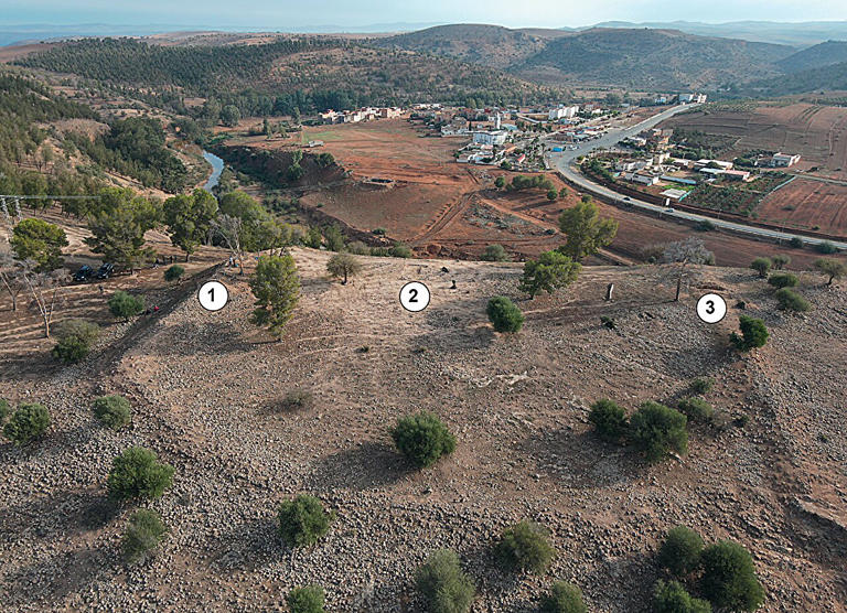
Oblique drone photograph of the so-called 'éperon barré,' with the village of Aït Siberne in the background (east-facing). Credit: Libyan Studies (2026). DOI: 10.1017/lis.2026.10037
Oblique drone photograph of the so-called 'éperon barré,' with the village of Aït Siberne in the background (east-facing).
Credit: Libyan Studies (2026). DOI: 10.1017/lis.2026.10037

In the hills of northwestern Morocco, overlooking the river that gives the site its name, research at Oued Beht is bringing to light a previously unknown chapter of the region's past. The discovery of a substantial built structure suggests that, during the second millennium BC, communities in northwestern Africa were actively shaping their environment. They were also engaging in broader networks of interaction across the Mediterranean world.

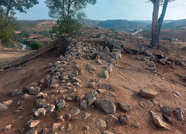
The wall discovered at Oued Beht, a site in Morocco that is steadily rewriting the history of the Maghreb. Credit: Libyan Studies (2026). DOI: 10.1017/lis.2026.10037
The wall discovered at Oued Beht, a site in Morocco that is steadily rewriting the history of the
Maghreb. Credit: Libyan Studies (2026). DOI: 10.1017/lis.2026.10037

Previous research by the Oued Beht Archaeological Project had already brought to light what is likely the earliest and largest agricultural complex ever discovered in Africa outside the Nile Valley. It dates to around 5,400–4,900 years ago. New excavations carried out in 2023—in which we took part—have now deepened our understanding of the site.

Our new study published in the journal Libyan Studies shows how we uncovered the earliest known large-scale construction of a probably defensive nature in North Africa beyond the Nile Valley. It's about 4,000–3,500 years old.

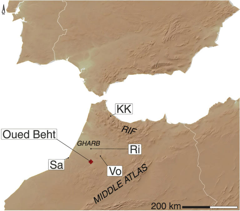
Oued Beht in today's Morocco, separated from Spain above it by the ocean. Credit: Libyan Studies (2026). DOI: 10.1017/lis.2026.10037
Oued Beht in today's Morocco, separated from Spain above it by the ocean.
Credit: Libyan Studies (2026). DOI: 10.1017/lis.2026.10037

It's not known exactly what threats these wall-like structures were designed to counter. They likely relate to increasing competition over land, resources and possibly control of movement through the landscape, rather than to "invaders." Constructions like these suggest communities felt the need to protect themselves or assert power over strategic locations.

This discovery pushes back the evidence for organized defensive architecture in the Maghreb and suggests that societies in this region at this time were more complex and structured than previously believed.

Polished stone axe at Oued Beht. Credit: Libyan Studies (2026). DOI: 10.1017/lis.2026.10037

Polished stone axe at Oued Beht.
Credit: Libyan Studies (2026). DOI: 10.1017/lis.2026.10037

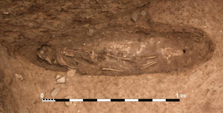
Our study also reveals how the ridge of Oued Beht would become a focal point again in the medieval period, during the 11th–13th centuries AD. The same defensive structure was rebuilt, a hamlet or farm was established on a nearby hilltop, and people were buried in a cemetery between the two areas.

Exposed skeletal remains at Oued Beht. Credit: Libyan Studies (2026). DOI: 10.1017/lis.2026.10037
Exposed skeletal remains at Oued Beht.
Credit: Libyan Studies (2026). DOI: 10.1017/lis.2026.10037

Together, these findings provide rare archaeological insights into rural communities during both prehistoric and medieval times. They help us understand how societies developed and maintained themselves in a region too often left out of the history books.

A prehistoric hub in the Maghreb

For a long time, the later prehistory of North Africa's Maghreb region (the Mediterranean countries of Morocco, Algeria and Tunisia) has been poorly understood. Compared with neighboring areas such as Iberia in southwestern Europe or Athens in the eastern Mediterranean, archaeological evidence was often fragmentary. In the past few years, this has changed completely.

Excavations at Oued Beht have revealed a large concentration of human activity spread across at least 10 hectares (25 acres). The earliest major phase dates to the mid-fourth and early third millennia BC, or the Final Neolithic period.

Environmental evidence from plant and animal remains in the prehistoric era indicates a farming community cultivating crops such as barley and wheat. They also exploited wild plants and kept livestock.

The site was also an important center of craft production. Thousands of polished stone axes and other tools have been discovered, along with finely made pottery, sometimes decorated with painted patterns.

It's still uncertain whether prehistoric Oued Beht functioned as a permanent village, a seasonal center or something less familiar. But it was clearly a major focus in the landscape of northwestern Morocco.

The defensive wall

The presence of potentially ancient earthworks and walls had been noted since the 1930s. The French archaeologist Armand Ruhlmann first documented a configuration of three walls, with the fourth side protected by the natural scarp of the ridge, describing a defensive éperon barré (barred spur). Their precise nature and date remained uncertain until now.

NEW | The Lost Labyrinth of Egypt: Excavations Begin!

New excavations have clarified the existence of a multiphase ditch, rampart and wall built across a narrow section of the Oued Beht ridge between the river and a ravine. This cut off and protected the ridge's southern tip.

Radiocarbon dating of deposits associated with these structures gave us the timelines in our study.

They place its original construction at a time equivalent to the Bronze Age of the rest of the western Mediterranean. This makes it the earliest confirmed defensive construction in North Africa outside Egypt.

What was this construction for?

This structure raises important questions about the society that built it. Building an embankment and ditch system required planning, coordination and the mobilization of labor. This suggests a community capable of organizing complex construction initiatives.

During the earlier Neolithic phase, activity at Oued Beht focused on the larger and more open northern area of the site. By the period of our new study, focus had shifted to the narrower, more defensible southern ridge. This may reflect a shift in settlement strategies.

Mediterranean connections

The second millennium BC was a dynamic period across the Mediterranean. In southern Iberia, Argaric societies (about 2200–1550 BC) in today's Europe were developing complex, often hilltop settlements. They were characterized by planned architecture, advanced metallurgy (especially bronze production) and marked social hierarchies visible in burial practices. These communities often constructed fortified sites and strategically located settlements that controlled surrounding territories.

Increasing evidence suggests that communities in northwestern Africa were connected to wider Mediterranean networks. This includes today's Spain and Portugal. The discoveries at Oued Beht indicate that the Maghreb was not isolated. It participated in broader processes shaping the western Mediterranean.

The defensive system at the site may reflect wider transformations in social organization and regional interaction. There may have been growing competition over resources, control of movement and more formalized leadership structures.

Rewriting history

The discoveries at Oued Beht highlight how much remains to be learned about the deep history of North Africa. The defensive wall shows that communities here were able to coordinate large construction projects and points to social transformations that are only very tentatively beginning to be recognized.

The medieval remains demonstrate that the ridge was used again many centuries after the prehistoric settlement had been abandoned. Oued Beht was not simply a single-period settlement but a landscape repeatedly selected by different communities across millennia.

As research continues, this location may become key to understanding how societies in the Maghreb evolved from early farming communities to the medieval rural world.

More information:

  • Giulio Lucarini et al, Expanding Oued Beht: Final Neolithic, Bronze Age, medieval and later discoveries from excavation and survey in 2023, Libyan Studie }s (2026). DOI: 10.1017/lis.2026.10037
  • This article is republished from The Conversation under a Creative Commons license. Read the original article.
  • Provided by The Conversation
  • This story was originally published on Phys.org.
The Moroccan Discoveries Rewriting Human History
Hoe vind je dit bericht?
Geschreven door peter om 20:37 Stuur door

EXCLUSIVE - Mysterious symbols spanning the globe hint at a lost civilization 38,000 years ago

EXCLUSIVE - Mysterious symbols spanning the globe hint at a lost civilization 38,000 years ago

For centuries, mainstream archaeologists have dismissed the idea that an advanced civilization existed long before modern times.

Now, an independent researcher claims he has uncovered 'paradigm-shifting evidence of a lost civilization' that hid a sophisticated code through geometry, symbolism, and monument design across the globe to preserve its knowledge ahead of catastrophic events.

Matthew LaCroix told Daily Mail the discovery, sparked by a recent find in Egypt, links symbols across continents and dates back 38,000 to 40,000 years.

According to LaCroix, this civilization tracked cosmic cycles, anticipated global disasters, and embedded teachings about human origins, the structure of the universe, and divine existence into monuments and sacred sites.

His investigation began after identifying recurring giant T-shapes, three-level indents, and step pyramids carved into ancient stones worldwide.

'These specific symbols that are built in different size proportions, and the symbols are found in ancient stones around the world, are not supposed to exist; no cultures are supposed to have any cross-platform,' LaCroix explained.

The symbols appear in locations ranging from Turkey's Van region to South America and Cambodia.

According to LaCroix, the origin of this global system lies in eastern Turkey's Lake Van region at a site known as Ionis. 

He described it as the earliest source of the civilization's symbols, architecture, and teachings, dating it to around 40,000 years old. He argues it preserves the original blueprint later carried to places such as Giza and Tiwanaku.

The investigation began after finding recurring giant T-shapes (pictured), three-level indents and step pyramids carved into ancient stones worldwide, patterns he said should not exist across unrelated cultures, suggesting a shared origin rather than independent development.

The investigation began after finding recurring giant T-shapes (pictured), three-level indents and step pyramids carved into ancient stones worldwide, patterns he said should not exist across unrelated cultures, suggesting a shared origin rather than independent development.

The symbols appear in locations ranging from Turkey's Van region to South America and Cambodia

The symbols appear in locations ranging from Turkey's Van region to South America and Cambodia

Recurring motifs, giant T-shapes, step pyramids, inverted pyramids, lions, and sacred geometry, appear at Ionis in their most concentrated form before repeating at distant sites worldwide, LaCroix added.

Nearby, the site of Kefkalesi provides one of the clearest examples of these symbols in stone.

The four-foot-by-four-foot basalt carving, known as the Kefkalesi relief, contains complex iconography that mirrors the symbols found at Ionis, Giza, and South American sites.

'This relief became one of the most important artifacts for my research,' LaCroix explained. 'It connects Egypt back to this region and lets us back-engineer the global pattern.'

He pointed out repeating motifs: 'Here are the T-shapes, repeating over and over. Here's your step pyramid with three doors and the lion right here. These same elements appear repeatedly across sites worldwide.'

Regarding the lion, he added, 'The lion is a guardian, and its placement helps explain the structure of the code.'

LaCroix said the relief solidified his interpretation of the symbols and accelerated his analysis of similar structures at the Sphinx Temple in Egypt.

Mainstream archaeologists, however, date known Lake Van sites to the Urartian period thousands of years ago and say there is no evidence supporting a pre-Ice Age global civilization, and no peer-reviewed research currently supports LaCroix’s proposed dating.

Another nearby site, Kefkalesi, provides one of the clearest examples of these recurring symbols in stone. Circled are step pyramids. The top is pointing to an inverted pyramid, and the center is highlighting a T

Another nearby site, Kefkalesi, provides one of the clearest examples of these recurring symbols in stone. Circled are step pyramids. The top is pointing to an inverted pyramid, and the center is highlighting a T

The image, which shows the Sphinx Temple located in front of the statue and closed to the public, revealed what he believes is an inverted step pyramid embedded in the structure

The image, which shows the Sphinx Temple located in front of the statue and closed to the public, revealed what he believes is an inverted step pyramid embedded in the structure

His breakthrough moment came in November 2025, when he re-examined a framed photograph of Egypt's Sphinx Temple he had owned for eight years.

article image

The image, which shows the Sphinx Temple in front of the statue and closed to the public, revealed what he believes is an inverted step pyramid embedded in the structure.

'There, in front of me. It was like I had never seen it before. There was the inverted step pyramid, but the right side had been broken off,' he said.

That realization prompted LaCroix to analyze the entire Giza Plateau, where he identified repeated appearances of inverted step pyramids and giant T-shapes in the Sphinx Temple, Valley Temple and the mortuary temples of Khafre and Menkaure.

Some researchers have suggested the Sphinx was originally carved as a lion before later being reworked with the face of a pharaoh, though the theory is not accepted among mainstream archaeologists.

Using astronomical precession, a slow wobble in Earth's axis, and the Sphinx's proposed alignment with the constellation Leo, LaCroix narrowed the construction date to either around 12,000 years ago, near the end of the last Ice Age, or 38,000 years ago, one full precessional cycle earlier.

He dismissed the younger date, citing theories of catastrophic flooding that would have destroyed surface structures, and instead placed the Great Pyramids, Sphinx, and Valley Temple at roughly 38,000 years old.

Matthew LaCroix (right) told Daily Mail the discovery, sparked by a recent find in Egypt, links symbols across continents and dates back as far as 38,000 to 40,000 years ago. Pictured is a T-shaped symbol at the center of the stone slab

Matthew LaCroix (right) told Daily Mail the discovery, sparked by a recent find in Egypt, links symbols across continents and dates back as far as 38,000 to 40,000 years ago. Pictured is a T-shaped symbol at the center of the stone slab

LaCroix said the same architectural layout also appears in South America at Tiwanaku and Puma Punku.

'The temple layout of the Acapana Pyramid, which is in Tiwanaku, is the exact same shape as the stone in those designs themselves, as the temple layout,' he explained.

LiDAR scans of Puma Punku revealed a massive T-shaped design, which LaCroix says reinforces his theory of a shared architectural template. 

'So, Fumapunku and Tiwanaku are like a mirror of Egypt in South America,' he said.

He also identified step pyramid designs inside the mortuary temples of Khafre and Menkaure (left)
 

He also identified step pyramid designs inside the mortuary temples of Khafre and Menkaure (left)

The patterns he said should not exist across unrelated cultures, suggesting a shared origin rather than independent development

The patterns he said should not exist across unrelated cultures, suggesting a shared origin rather than independent development

He also suggested that the lost civilization's messages were to tell humanity about the universe. The left symbolized the underworld, the center for reality andthe  right signified the spiritual world

He also suggested that the lost civilization's messages were to tell humanity about the universe. The left symbolized the underworld, the center for reality andthe  right signified the spiritual world

At the center of LaCroix's interpretation is what he calls a cosmogram, an ancient geometric model representing the structure of the universe.

According to LaCroix, symbols such as three-level step pyramids, inverted pyramids, and T-shapes encode layered realities: the non-physical underworld, the physical realm, and the celestial realms.

'The left door represents the realm of reality called the underworld, or non-physical realm of reality,' he explained. 'Its counter, on the opposite, is the right door, which is the celestial realms of reality, where the angels are.'

The central vertical axis of the T symbol represents the 'middle door' that balances the system, a concept often referred to in ancient cosmology as the axis mundi, or central point connecting all realms.

'They're showing us how all of reality works, and how it all balances,' LaCroix said.

He tied this framework to preserved Egyptian traditions, particularly Hermeticism, an ancient spiritual and philosophical system attributed to Hermes Trismegistus that emphasizes humanity's connection to the cosmos, the divine, and hidden knowledge.

LaCroix believes the ancient code was deliberately hidden to preserve knowledge humanity later inverted.

Speaking philosophically, he added: 'Guess what, spoiler alert, we're doing everything basically the inverse opposite of what we're supposed to,' he warned.

He said the evidence suggests humans were once understood as divine and interconnected with all existence.

'We have ancient proof that shows that we're a divine being that's connected to the all, and a part of everything... we're supposed to be living in harmony with the Earth and the universe,' LaCroix said.


The 38,000-Year-Old Code: Lost Civilization of the Gods

The Ancient Code of a Lost Civilization? 🗝️🗿

{ https://www.dailymail.com/sciencetech/index.html }

Hoe vind je dit bericht?
Geschreven door peter om 16:12 Stuur door

New 'code' found in Egypt's Great Pyramid may finally reveal its true purpose

New 'code' found in Egypt's Great Pyramid may finally reveal its true purpose

By STACY LIBERATORE, US SCIENCE & TECHNOLOGY EDITOR

The Great Pyramid has guarded its secrets behind millions of tons of stone, but a new paper claims its greatest message may have been hiding in plain sight.

Independent researcher Sefy Levy argued that carefully chosen measurements on the monument’s exterior form a numerical system designed to survive long after its builders were gone.

Rather than being carved into a wall, the alleged code is said to be embedded in the pyramid’s height, base, sloping sides and overall shape.

Levy claimed those dimensions produce striking matches with the cycles of the moon, the calendar and planets visible to the naked eye.

He believes the numbers were intended to preserve the Egyptians’ knowledge of mathematics, time and the heavens for eternity.

'The pyramid was not built to last forever because it contained something valuable,' Levy wrote. 

'It was built to last forever because it was something valuable.'

The paper, posted in August, concluded with its boldest claim: 'The pyramid is not a container for knowledge. It is the knowledge, made stone.'

Independent researcher Sefy Levy argued that carefully chosen measurements on the monument’s exterior form a numerical system designed to survive long after its builders were gone

Independent researcher Sefy Levy argued that carefully chosen measurements on the monument’s exterior form a numerical system designed to survive long after its builders were gone

The interpretation remains highly speculative, as the paper has been posted on SSRN and Zenodo but has not undergone independent peer review. 

Levy has acknowledged that the numerical matches were initially found after the measurements and target values were known.

Mainstream Egyptology regards the pyramid as a funerary monument built for Khufu, around 4,500 years ago.

 Its empty granite sarcophagus, mortuary complex and royal cemetery support that function, but do not prove Khufu was buried there. 

No ancient text says its dimensions encode astronomy.

To uncover the alleged pattern, Levy examined the pyramid’s key measurements and divided them using fractions employed by ancient Egyptian scribes.

According to the paper, the answers repeatedly come close to numbers important in mathematics and astronomy.

One simple calculation produces 27.5, a near match for the roughly 27.55-day interval between successive lunar perigees, when the moon reaches its closest point to Earth.

Another produces exactly 70, which Levy connected to the roughly 70-day interval between the heliacal setting and rising of Sirius, when it was hidden by the sun’s glare. 

Rather than being carved into a wall , the alleged code is said to be embedded in the pyramid’s height, base, sloping sides and overall shape. Above is a tunnel entrance into the Great Pyramid

Rather than being carved into a wall , the alleged code is said to be embedded in the pyramid’s height, base, sloping sides and overall shape. Above is a tunnel entrance into the Great Pyramid

Egyptian tradition also associated about 70 days with mummification, although the match proves no deliberate connection.

Levy claimed other calculations come close to the repeating cycles of Saturn, Jupiter, Venus and Mars as they move across Earth’s sky. 

article image

He also argued that the pyramid’s proportions produce figures resembling pi and the golden ratio.

Together, the theory suggests the builders transformed the pyramid into a permanent stone record of their understanding of time, space and the heavens.

To test whether similar patterns would appear by chance, Levy generated 100,000 hypothetical Old Kingdom-style pyramids. 

These were not complete designs: a program varied their base widths from 75 to 440 royal cubits and their slopes across an ancient range.

The same test was applied to every model, and Levy reported that 2,419, about 2.4 percent, scored as many matches as the Great Pyramid or more. 

He argued that this makes coincidence less likely, but it remains his own simulation rather than independent confirmation. One stricter comparison was inconclusive.

Levy suggested the Great Pyramid was built to represent an ancient Egyptian tradition. It says the first land rose from a water world. He also believes it really happened in a place in Africa called the Eye of the Sahara (pictured)

Levy suggested the Great Pyramid was built to represent an ancient Egyptian tradition. It says the first land rose from a water world. He also believes it really happened in a place in Africa called the Eye of the Sahara (pictured)

The numerical code is only one part of Levy’s much more radical argument about the monument’s purpose.

Levy’s larger theory begins with an Egyptian creation tradition in which the first land rose from a world covered in water.

The tradition in which the first land rose from a chaotic, dark water world is known as the Heliopolitan creation myth, centered around the primeval mound called the benben.

He believes the pyramid was built to represent the primordial mound from which creation began.

Levy then made a much more controversial claim, suggesting the story may have been based on a real place where some distant ancestors of the Egyptians could have lived.

His candidate is the Eye of the Sahara, a huge ring-shaped formation in Mauritania with raised land at its center. 

Thousands of years ago, when the Sahara was greener and wetter, it may have been surrounded by water.

The theory suggests that communities left as the region dried and eventually travelled east toward the Nile, taking memories of their old home with them.

Levy believes later generations recreated that memory at Giza. The pyramid represented the hill, while a harbor and lost Nile branch placed water at the complex’s edge. He interprets the westward causeways as symbolically connecting the setting sun, the dead and the proposed ancestral homeland.

In other words, Levy argues that the Great Pyramid preserved a story about where some of Egypt’s distant ancestors may have come from.

There is no direct evidence connecting the Eye of the Sahara to Giza or proving that this journey happened.


Great Pyramid’s TRUE Purpose? This Hidden Code Could Change Everything

{ https://www.dailymail.com/sciencetech/index.html }

Hoe vind je dit bericht?
Geschreven door peter om 15:48 Stuur door

Giant 'megalith structure' spotted on ocean floor sparks alien base theories

Giant 'megalith structure' spotted on ocean floor sparks alien base theories

A mysterious structure spotted on the seafloor near Papua New Guinea has sparked claims that an alien base may be hiding below the surface.

Self-described UFO researcher Scott C Waring identified the enormous rectangular-shaped anomaly, suggesting it is approximately 10 miles long and four miles wide.

Waring said he discovered the formation while exploring the global ocean-floor maps produced by the Seabed 2030 project.

He described it as a ‘megalith structure’ and estimated that it could extend between 10 and 15 miles beneath the seabed.

Waring claimed its immense size, unusual shape and isolated location suggest it is far more than a natural geological formation.

‘This alien base looks clean and taken care of,’ he wrote, claiming its apparently uncovered surface meant it was still occupied.

He also claimed that 'aliens are living there right now.'

However, there is no independent evidence that the structure is artificial, occupied or anything other than a natural formation or mapping anomaly.

Self-described UFO researcher Scott C Waring identified the enormous anomaly, suggesting it approximately 10 miles long and four miles wide

Self-described UFO researcher Scott C Waring identified the enormous anomaly, suggesting it approximately 10 miles long and four miles wide

Waring shared his discovery on his UFO Sightings Daily YouTube channel, saying: 'Found something that you’re not even going to believe. 

'You can’t even comprehend this exists because it’s real, and it’s out there under the ocean right now.' 

He went on to estimate that the structure could feature 20 different buildings, each the size of the Empire State Building. 

'This is just huge. It's big enough for an entire city to live inside of this. It is massive,' Waring said. 

Many of Waring's followers were also sure that the structure on the map was something worth investigating.

One user said, 'cool find,' while another simply commented, 'aliens.' 

However, confirming an alien would require detailed sonar surveys, underwater photographs and physical evidence.

Even more, the US government has long maintained that there is no evidence that Earth has been visited by aliens.

A mysterious structure spotted on the seafloor near Papua New Guinea has sparked claims that an alien base may be hiding below the surface

A mysterious structure spotted on the seafloor near Papua New Guinea has sparked claims that an alien base may be hiding below the surface

Waring announced another mysterious find this week, claiming to have uncovered evidence of a lost civilization off the coast of Cuba.

The seafloor data shows a series of faint, roughly parallel and intersecting lines across the seabed west of the island.

He estimated that the apparent site stretches seven or eight miles in one direction and approximately three miles in the other.

‘This new map is extraordinary,’ Waring said in a YouTube video highlighting the area. ‘In this one location, there is an ancient sunken city.

‘There are a lot of geometric shapes, which indicate there is something down here that was intelligently made,’ he added.

However, no archaeologists or marine scientists have examined the site or confirmed that the patterns represent physical, human-made structures. 

Waring said the scale and regularity of the shapes convinced him that they were unlikely to have formed naturally.

Waring other shapes near Cuba and Haiti (left of the island), arguing they could be the remains of a city constructed by ancient humans

Waring other shapes near Cuba and Haiti (left of the island), arguing they could be the remains of a city constructed by ancient humans

He considered whether the supposed builders were humans or visitors from another world.

‘Now, is it ancient alien or is it ancient humans?’ Waring asked on his site, UFO Sightings Daily. ‘That’s the big question.’

He ultimately favored a lost human civilization, arguing: ‘I would probably go with ancient humans because the geometric design looks more primitive and less futuristic to me.'

Waring suggested the shapes could mark the remains of a settlement resembling Atlantis, the legendary civilization said to have disappeared beneath the sea.

‘This could be a long-lost city, long ago like Atlantis or something, built on the coral reef of an island area,’ he said.

He speculated that a powerful earthquake may have destabilized the island, causing the reef and everything constructed upon it to collapse into the ocean.

‘An earthquake just could have rattled it so much that coral could have just collapsed on itself and the whole island could have sunk,’ Waring explained.


Extraterrestrial Mysteries on the Ocean Floor | Ancient Aliens

 { https://www.dailymail.com/sciencetech/index.html }

Hoe vind je dit bericht?
Geschreven door peter om 21:07 Stuur door

Unravelling the mystery of the Devil's Arrows: Study reveals how prehistoric builders hauled 25-tonne rocks 11 miles across Yorkshire to build the landmark 5,000 years ago

Unravelling the mystery of the Devil's Arrows: Study reveals how prehistoric builders hauled 25-tonne rocks 11 miles across Yorkshire to build the landmark 5,000 years ago

When it comes to ancient stone structures, Stonehenge is usually the first landmark to spring to mind. 

But over in Yorkshire, another prehistoric monument has left scientists stumped for centuries. 

Prehistoric builders hauled 25-tonne stones 18km to build Britain’s talleststone row

The Devil's Arrows is a set of three huge stones near Boroughbridge, dating back around 4,500–5,000 years. 

Each weighing around 25 tonnes and standing at almost 23ft (seven metres) tall, how the enormous stones got there has remained unclear. 

Now, scientists from the University of York and Curtin University think they've cracked it. 

Their new analysis suggests the stones were collected and transported from Brimham Rocks, about 11 miles (18km) away.

'Sites in southern England and Scotland receive considerable attention, but monuments like the Devil's Arrows have remained comparatively understudied despite their significance,' said Dr Jim Leary, from the University of York.

'We have now proved that Neolithic communities moved several 25–tonne stones 18km across Yorkshire, transforming a familiar site into an epic quest to create a sacred landscape.'

The Devil's Arrows are positioned across 174 metres on the western outskirts of Boroughbridge, and date back to roughly 2500–2000 BC, making them some of the oldest stone structures in the UK

The Devil's Arrows are positioned across 174 metres on the western outskirts of Boroughbridge, and date back to roughly 2500–2000 BC, making them some of the oldest stone structures in the UK 

The Devil's Arrows are positioned across 174 metres on the western outskirts of Boroughbridge, and date back to roughly 2500–2000 BC, making them some of the oldest stone structures in the UK. 

Although they're slightly younger than Stonehenge, the stones are actually even taller, at almost 23ft (seven metres). 

While the Devil's Arrows stand on Triassic Sherwood Sandstone, the stones themselves are made of Pennine Basin Millstone Grit. 

This has raised questions about how they got to their location in Boroughbridge. 

Some experts have argued they were hauled there by humans, while others are convinced they were transported by ice–age glaciers. 

To settle the debate once and for all, the researchers analysed the minerals in the stones.

Dr Anthony Clarke, geochemist at Curtin University in Australia, said: 'Our research shows these stones weren't simply taken from the nearest available source – they were deliberately chosen from a challenging landscape 18 kilometres away.

'Plumpton Rocks, which is closer to the Devil's Arrows, had previously been identified as the probable source of the stones. 

Their new analysis suggests the stones were collected and transported from Brimham Rocks (pictured), about 11 miles (18km) away

Their new analysis suggests the stones were collected and transported from Brimham Rocks (pictured), about 11 miles (18km) away

Although they're slightly younger than Stonehenge, the stones are actually even taller, at almost 23ft (seven metres)

Although they're slightly younger than Stonehenge, the stones are actually even taller, at almost 23ft (seven metres)

What are the Devil's Arrows?

The Devil's Arrows, located near Boroughbridge in northern England, stand up to seven metres tall and form a rare stone alignment in a lowland setting. 

The stones are believed to have been transported and erected during the Late Neolithic or Early Bronze Age, possibly around 2000 BC.

Despite their scale and prominence, their origins have remained a mystery until now. 

'Our findings instead point to Brimham Rocks, showing that prehistoric builders transported these enormous stones significantly further than thought.

'Each stone weighs more than 25 tonnes, so moving them would have required incredible planning, coordination and engineering skill.

'This tells us prehistoric people placed real importance on the landscape itself. It wasn't just about convenience – the location the stones came from likely held meaning for them.'

While three stones remain today, historical accounts suggest the site once held at least five stones. 

In the mid–16th century, Tudor antiquarian John Leland recorded a fourth standing stone, but decades later it was said to be missing. 

In 1687, it was recorded that locals had broken up a fallen stone, using part of it to construct Peg Bridge over the River Tutt and taking the top segment to Aldborough manor.

Then, in the 19th century, antiquarian J.R. Walbran proposed that another fallen monolith had been recycled into the Battle Cross – an 18ft (5.5 metre) monument crafted in the 15th century to commemorate the 1322 Battle of Boroughbridge.

In the new study, the researchers were able to confirm Walbran's theory.

Ancient builders hauled 25-ton stones 18 km to build Britain’s tallest prehistoric stone row

Location and appearance of the Devil’s Arrows on the western outskirts of Boroughbridge, Yorkshire. The insets show the alignment and spacing of the three surviving stones, along with scaled profiles of the Devil’s Arrows and the Battle Cross Monument. The bottom panels show photographs of the three surviving megaliths.

Credit: A. Clarke et al., Proceedings. Mathematical, Physical, and Engineering Sciences (2026)

While three stones remain today, historical accounts suggest the site once held at least five stones

While three stones remain today, historical accounts suggest the site once held at least five stones

Mineral fingerprinting proved that the medieval cross – which stands in Aldborough today – is a carved segment of a long–lost Devil's Arrow.

Justin Scully, General Manager for Fountains Abbey & Studley Royal and Brimham Rocks, said: 'The Devil's Arrows have inspired stories and sparked curiosity for generations.

'Local legend tells of the Devil standing on How Hill and hurling giant stone arrows towards Boroughbridge, only for them to fall short and land where they stand today.

'While the folklore remains a much–loved part of their story, it's wonderful to discover that the real journey of these stones is every bit as extraordinary.

'This fascinating research reveals a direct link between Brimham Rocks and the Devil's Arrows, connecting two remarkable Yorkshire landscapes in our care. 

'We're incredibly grateful to the researchers for helping us uncover this new chapter in the stones' story and deepen our understanding of the people who shaped this landscape thousands of years ago.'

RELATED

YORKSHIRE: The Tallest Megalith Nobody Talks About And It's Not Stonehenge

How Did Prehistoric People Move 25-Tonne Stones? 🗿

Britain's Hidden Megaliths Have A Pattern Nobody Can Explain

{ https://www.dailymail.com/sciencetech/index.html }

Hoe vind je dit bericht?
Geschreven door peter om 15:31 Stuur door

Ancient Alien Base In Black Sea Found! Its name is Eden! Yes you heard me right, UFO Sighting News, Sept 8, 2026

Ancient Alien Base In Black Sea Found! Its name is Eden! Yes you heard me right, UFO Sighting News, Sept 8, 2026

Screenshot%202026-09-07%20at%208.15.04%E2%80%AFPM.png
Above screenshot is edited by hand by me to sharpen its details and correct its color. Below is untouched from map version.

Screenshot%202026-09-07%20at%206.38.44%E2%80%AFPM.png
Date of discovery: Sept 8, 2026
Location of discovery: 90 miles out into the Black Sea
Map used:
I was searching areas of interest when I found this last night before I went to bed. This alien base has finger like structures that are over 10 miles long and 3 miles wide. Its in a location that is 90 miles from the closest land, but its built on the cliff edge deep under water where no humans would ever would ever go. This base I is over 500,000 years old and linked directly to the ancient alien race who genetically engineered the human species many times...and created a base which I believe is called Eden...thats an Anunnaki name. Ancient texts cite the location to Eden to be within 450 miles of this alien base. It is the highest detailed, largest alien base I have ever found on Earth maps and I found dozens. I also believe the base is long since abandoned until they return...which means alien tech of the gods could be in human hands of whom ever reaches this base first. 
Scott C. Waring - UFO Sightings Daily 
 
RELATED

Ancient Aliens: The Shocking Theory Behind the Gods (S1)

{ https://www.ufosightingsdaily.com/ }

Hoe vind je dit bericht?
Geschreven door peter om 17:43 Stuur door

A stunning discovery at Giza could shed new light on ancient Egypt

A stunning discovery at Giza could shed new light on ancient Egypt

What does the tunnel look like?

©Provided by The Daily Digest

An ancient Egyptian mystery
In 2023, Egyptian officials announced a remarkable archaeological discovery: a previously unknown corridor hidden inside the Great Pyramid of Giza. The find offers new clues about the monument’s design and could help researchers better understand how it was constructed and why its hidden spaces were created.

At the north entrance of the pyramid

©Provided by The Daily Digest

At the north entrance of the pyramid
At a press conference in front of the Pyramid of Giza in early March of 2023, Egypt's Minister of Tourism and Antiquities, Ahmed Issa, said that the tunnel was discovered on the north side of the pyramid.

Findings from landmark excavation

©The Daily Digest

What does the tunnel look like?
Egypt's Ministry of Tourism and Antiquities said in the statement that the mysterious tunnel was nine meters long or 30 feet long and more than two meters or six feet wide.

Groundbreaking technology

©Provided by The Daily Digest

Groundbreaking technology
Thanks to an endoscopic camera with a diameter of 5 mm, which penetrated between the stones without causing any damage, scientists were able to take pictures. These show a stone cavity with a gabled roof.

An international scientific mission

©Provided by The Daily Digest

An international scientific mission
This secret room was discovered as part of an international research project called ScanPyramids. Since 2015, German, French, Japanese and Canadian universities have been collaborating with Egyptian archaeologists to study the pyramids and learn more about the construction methods used to build the pyramids more than 4,500 years ago.

Look through the stones

©Provided by The Daily Digest

Look through the stones
ScanPyramids' mission is to use non-invasive technologies to look through the stones to discover previously unknown internal structures within the pyramids.

©Provided by The Daily Digest

"We didn't want to dig indiscriminately"
Ground-penetrating radar and ultrasonic testing are the techniques used to discover this space through the stones. "We already knew in 2017 that there was a cavity behind it, we just didn't want to dig indiscriminately (...), so additional measurements were needed," explains research engineer Sébastien Procureur, who worked on the project.

A space that remains mysterious

©Provided by The Daily Digest

A space that remains mysterious
"Discovering an empty space in a pyramid is something special," explains German professor Christian Große, leader of the research team. "But the fact that this space is large enough to accommodate several people makes it even more important."

What was it for?

©Provided by The Daily Digest

What was it for?
According to Zahi Hawass, a famous Egyptian archaeologist, it is "very possible" that this room is "protecting something". It could even house a huge treasure: "In my opinion, it protects the true burial chamber of the Egyptian monarch Khufu," adds the Egyptologist.

"There is not the direct connection that we could hope for"

©Provided by The Daily Digest

"There is not the direct connection that we could hope for"
Sébastien Procureur remains more skeptical: "That's a bit of the bad news: there isn't the hoped-for direct connection to the 'Big Void' (the so-called 'great void' at the heart of the pyramid where the pharaoh's body is said to be)". However, research is ongoing to clarify this question.

The Great Pyramid of Khufu

©Provided by The Daily Digest

The Great Pyramid of Khufu
The Pyramid of Khufu is the largest of the Pyramids of Giza. For thousands of years it was the tallest, most voluminous and most massive man-made structure in the world. It was built about 45 centuries ago (ca. 2551-2528 BC) to house the body of the pharaoh Khufu, the second ruler of the dynasty.

A fascinating construction

©Provided by The Daily Digest

A fascinating construction
An achievement that has always impressed and fascinated scientists. Its many architectural features are further mysteries that have not been solved until now. The researchers' only certainty today is the relatively short construction period: just 25 years.

The existence of the 'Big Void' was discovered in 2017

©Provided by The Daily Digest

The existence of the 'Big Void' was discovered in 2017
The "Big Void" is one of the questions that are still unanswered about the Khufu pyramid. Its existence was discovered by the Scan Pyramids teams in 2017. It is a "cavity at least 35 meters long and about 3 meters high," as Sébastien Procureur explains in an interview for Sciences et Avenir magazine.

What is in the 'Big Void'?

©Provided by The Daily Digest

What is in the 'Big Void'?
Archaeologists don't yet know what's in the 'Big Void'. Hypotheses vary, it could simply be a cavity formed during the construction of the pyramid or, what scientists hope, the real burial chamber of the pharaoh Khufu.

The Mystery of Pharaoh Khufu

©Provided by The Daily Digest

The Mystery of Pharaoh Khufu
The tomb of Khufu could contain all the treasures of this ancient king, but also the corpse of the pharaoh, which has not yet been discovered.

The research goes on

©Provided by The Daily Digest

The research goes on
Only one thing is certain: the pyramid has not yet revealed all its secrets to us. The Scan Pyramids teams intend to deepen their research to gather new data and make more discoveries.

RELATED


Scientists Revealed New Giza Scans — And Found What’s Hidden Beneath the Pyramids

What Archaeologists Discovered Beneath the Sands of Egypt

They Found a 2,000-Year-Old Tech Hidden in Giza, Egypt

{ https://thedailydigest.com/en/ }

Hoe vind je dit bericht?
Geschreven door peter om 17:14 Stuur door

Ancient Alien City Found Under Ocean Near Cuba/Haiti Is It Aliens Or Is It Humans? New Discovery. UFO UAP Sighting News

Ancient Alien City Found Under Ocean Near Cuba/Haiti. Is It Aliens Or Is It Humans? New Discovery. UFO UAP Sighting News

UFO,%20UFOs,%20UAP,%20UAPs,%20UFO%20sighting,%20UFO%20files,%20UFO%20video%20UAP%20files,%20UAP%20video,%20department%20of%20war,%20alien,%20aliens,%20infrared%20UFO,%20IR%20UFO,%20official%20UFO,%20Gov%20UFO,%20USA%20UFO%20copy.png

Date of discovery: Sept 7, 2026
Location of discovery: Off Cuba and Haiti Coast
Map used: 
Now I'm trying to record as many discoveries I make on this map before the public access is taken away. Yes, these discoveries will cause a political tidal wave and as always, the tools or often URLs will be deleted. Giving access to only businesses that pay. 
 
I found this underwater ancient city off the coast of Cuba today. The city looks ancient and made by early humans, but I can't discount the fact that it could be ancient aliens that built it. I believe the city was made along the edge of the island that collapsed during an earthquake, causing 95% of the island to become submerged. The only way to know for sure if its alien or not...is to go there and record close up video of the ancient structure, take samples and find out what its made from, doorway sizes tend to tell how tall the people were, also any ancient artifacts that might be left behind. There were many ancient alien civilizations here on Earth before humans were created...by aliens as an experiment to learn their own early history which they lost long ago. 
 
  • PS, I found even larger structures in much higher detail in a new location. Video coming soon. Its the best of these last three discoveries. 
Scott C. Waring - UFO Sightings Daily
RELATED

Impossible Places | The Strangest Underwater Cities Few Humans Have Ever Seen | 4K Documentary

Lost Underwater Cities Discovered Beneath the Ocean

{ https://www.ufosightingsdaily.com/ }

Hoe vind je dit bericht?
Geschreven door peter om 21:52 Stuur door

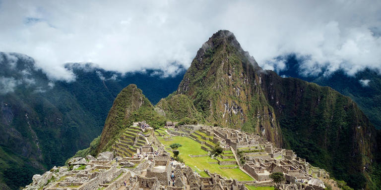
Archaeologists scanned Machu Picchu—and found hidden roads the world had never seen before

Archaeologists scanned Machu Picchu—and found hidden roads the world had never seen before

Story by Tim Newcomb
Using LiDAR, the team discovered 1.5 miles of pre-Columbian roads, but to protect the find, officials are keeping the specific location a secret.
© inigoarza - Getty Images

Here’s what you’ll learn when you read this story:

  • A new archaeological discovery at Machu Picchu deepens the site’s connections to the sacred Mandor Wall.
  • A team of researchers discovered 1.5 miles worth of roads connecting the site to additional terraces and platforms.
  • Officials are keeping the exact location of the new discovery under wraps to prevent any amateur treasure hunters from disturbing the site.

Archaeologists recently discovered 1.5 miles of pre-Columbian era roads leading to platforms and terraces near the Mandor Wall alongside Machu Picchu, buried under dense tropical forest. The Inca roads—nearly 8,000 feet high in the towering Andes—lead to a mixture of architectural features directly opposite Machu Picchu, further linking the larger complex together and showcasing the importance of the site. “This discovery complements and significantly revised hypotheses regarding the functioning of the entire complex,” Mariusz Ziółkowski, the director of the Center for Andean Studies at the University of Warsaw, said in a statement.

A UNESCO World Heritage Site, Machu Picchu was “probably the most amazing urban creation of the Inca Empire at its height,” according to UNESCO, with giant stone walls, terraces, and ramps created to look as though they’d been cut naturally in the continuous rock escarpments. “The natural setting,” according to UNESCO, “on the eastern slopes of the Andes, encompasses the upper Amazon basin with its rich diversity of flora and fauna.”

Within the larger Machu Picchu National Park, over 60 archaeological monuments connect via a network of roads. “These sites served various satellite functions in relation to the main complex, known as Llagta de Machu Picchu,” Ziółkowski said. “They are situated mainly on the left bank of the river, and it seemed that this was where the Incas has concentrated their urban planning efforts.”

The newly discovered roads sit on the opposite side of the river, showing that a larger area “underwent significant cultural transformations during the Inca period.” Adding new roads to the mix further highlights just how the site functioned 600 years ago, and presents a fresh lens through which experts can view Machu Picchu.

Machu Picchu's Hidden Roads Were Just Mapped—After 500 Years Under the Canopy #Shorts

The discoveries come thanks (in large part) to LiDAR imagery, which helps map environments, even ones covered in dense vegetation, without on-the-ground exploration. The team hopes to hit the field next year to mine the details of what they spotted remotely through excavation, which should help define the size and scope of the platforms and may uncover additional architectural features. The team also hopes to accurately date the new discoveries next year.

In the meantime, neither the Warsaw researchers nor the Peruvian government is sharing the exact location of the find, so as to keep amateur treasure hunters away.

The links to a variety of new sites near the Mandor Wall shows that the sacred function of the larger Machu Picchu site covered a wider area than previously believed. One .75-mile section of discovered road features a common Inca zigzag design, prompting experts to believe that they could find proof that the road dates to the time of Machu Picchu’s use.

RELATED VIDEOS

Machu Picchu’s Hidden Underground World Is More Incredible Than We Thought

They Found Roads Hidden Beneath the Jungle Near Machu Picchu… 😳

New Scans Revealed Machu Picchu’s Hidden Engineering — Experts Missed This
Hoe vind je dit bericht?
Geschreven door peter om 21:38 Stuur door

Meer van UFO'S of UAP'S, ASTRONOMIE, RUIMTEVAART, ARCHEOLOGIE, OUDHEIDKUNDE, SF-SNUFJES EN ANDERE ESOTERISCHE WETENSCHAPPEN - DE ALLERLAATSTE NIEUWTJES

↑ Terug naar de berichten