Ontdek de Fascinerende Wereld van UFO's en UAP's: Jouw Bron voor Onthullende Informatie!
Ben jij ook gefascineerd door het onbekende? Wil je meer weten over UFO's en UAP's, niet alleen in België, maar over de hele wereld? Dan ben je op de juiste plek!
België: Het Kloppend Hart van UFO-onderzoek
In België is BUFON (Belgisch UFO-Netwerk) dé autoriteit op het gebied van UFO-onderzoek. Voor betrouwbare en objectieve informatie over deze intrigerende fenomenen, bezoek je zeker onze Facebook-pagina en deze blog. Maar dat is nog niet alles! Ontdek ook het Belgisch UFO-meldpunt en Caelestia, twee organisaties die diepgaand onderzoek verrichten, al zijn ze soms kritisch of sceptisch.
Nederland: Een Schat aan Informatie
Voor onze Nederlandse buren is er de schitterende website www.ufowijzer.nl, beheerd door Paul Harmans. Deze site biedt een schat aan informatie en artikelen die je niet wilt missen!
Internationaal: MUFON - De Wereldwijde Autoriteit
Neem ook een kijkje bij MUFON (Mutual UFO Network Inc.), een gerenommeerde Amerikaanse UFO-vereniging met afdelingen in de VS en wereldwijd. MUFON is toegewijd aan de wetenschappelijke en analytische studie van het UFO-fenomeen, en hun maandelijkse tijdschrift, The MUFON UFO-Journal, is een must-read voor elke UFO-enthousiasteling. Bezoek hun website op www.mufon.com voor meer informatie.
Samenwerking en Toekomstvisie
Sinds 1 februari 2020 is Pieter niet alleen ex-president van BUFON, maar ook de voormalige nationale directeur van MUFON in Vlaanderen en Nederland. Dit creëert een sterke samenwerking met de Franse MUFON Reseau MUFON/EUROP, wat ons in staat stelt om nog meer waardevolle inzichten te delen.
Let op: Nepprofielen en Nieuwe Groeperingen
Pas op voor een nieuwe groepering die zich ook BUFON noemt, maar geen enkele connectie heeft met onze gevestigde organisatie. Hoewel zij de naam geregistreerd hebben, kunnen ze het rijke verleden en de expertise van onze groep niet evenaren. We wensen hen veel succes, maar we blijven de autoriteit in UFO-onderzoek!
Blijf Op De Hoogte!
Wil jij de laatste nieuwtjes over UFO's, ruimtevaart, archeologie, en meer? Volg ons dan en duik samen met ons in de fascinerende wereld van het onbekende! Sluit je aan bij de gemeenschap van nieuwsgierige geesten die net als jij verlangen naar antwoorden en avonturen in de sterren!
Heb je vragen of wil je meer weten? Aarzel dan niet om contact met ons op te nemen! Samen ontrafelen we het mysterie van de lucht en daarbuiten.
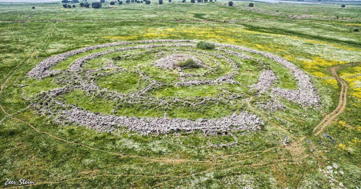
A recent archaeological investigation has offered a substantive reassessment of Rujm el-Hiri, a large protohistoric stone complex in the Golan Heights frequently characterized as the "Israeli Stonehenge." Rather than interpreting the site as a unique and isolated monument, a new study proposes that it constitutes the most elaborate expression of a broader regional tradition of circular stone-built architecture, and that dozens of similar structures have been hiding in plain sight for decades.
Published in PLOS One, the research conducted by Michal Birkenfeld, Olga Khabarova, Lev V. Eppelbaum, and Uri Berger documents over 30 large circular basalt structures within a 25-kilometer radius of Rujm el-Hiri, including 28 previously unrecorded examples. The authors attribute the prior absence of these features in the archaeological record primarily to methodological constraints associated with conventional ground-based survey techniques. Employing an integrated methodological framework, combining high-resolution satellite imagery, artificial intelligence, geophysical modeling, and spatial analysis, the study identifies a consistent architectural typology across the region.
The newly discovered structures are characterized by substantial outer walls constructed from basalt fieldstones, typically arranged in concentric configurations and, in many cases, interconnected by radial or orthogonal internal divisions. These recurring design elements indicate a shared constructional logic and suggest a coherent cultural or technological tradition during the protohistoric period.
Rujm el-Hiri itself, first identified in 1968 through aerial reconnaissance, comprises a central cairn encircled by multiple concentric stone rings, with an overall diameter exceeding 150 meters and containing roughly 40,000 tons of stone.
Its function has long been debated, with hypotheses ranging from funerary and ceremonial uses to defensive or astronomical purposes. However, the lack of definitive stratified material and associated settlement evidence has historically limited interpretative certainty. The present study challenges the longstanding assumption of the site's isolation by demonstrating the existence of a dense and previously under-recognized distribution of analogous structures across the basalt plateaus of the Golan Heights and adjacent regions.
"Gilgal Refaim is, of course, a very well-known site, and it was always considered to be a very unique site in the area," said lead researcher Michal Birkenfeld. "Most [of the sites we discovered] were not as elaborate and were of different sizes and levels of preservation, but they still have the same type of logic," he added.
(Photograph by Y. Shmidov and A. Wiegmann/PLoS ONE)
AI and Satellite Imagery Uncover the Past
Analysis of multi-temporal satellite datasets spanning from 2004 to 2024 enabled the identification of these features, many of which remain poorly preserved, partially dismantled, or obscured by subsequent land-use activities. Researchers processed archives from multiple satellite platforms, including Google Earth Pro and CNES/Airbus and applied AI techniques to reduce interference from shadows and seasonal vegetation, enabling the identification of features that had remained invisible in conventional surveys. The newly identified circles range from approximately 50 to 250 feet in diameter, and while smaller and more degraded than Rujm el-Hiri, they share the same fundamental architectural logic.
The clusters highlight repeated occupation or a long-standing use of particular locations. There is a non-random variation of structures found in spaces where most are located on gently sloping terrain or on high plateau sites, and those near seasonal water sources. The common proximity of such monuments with dolmens, tumuli, and field-wall networks tells that these were part of a large cultural landscape and may have played different roles in ritual, territory, and socio-economic affairs. Intriguingly, similar-looking sites have also been noted farther afield in Galilee and Lebanon, suggesting the tradition may have extended well beyond the immediate Golan region.
Reassessing Astronomical Alignments
The study further revisits long-standing hypotheses concerning astronomical alignments at the site. Emerging geophysical and palaeomagnetic evidence indicates that the region has experienced gradual yet measurable tectonic rotation over millennial timescales. As a result, the current orientation of architectural elements is unlikely to reflect their original spatial configuration, introducing significant uncertainty into earlier claims of deliberate celestial alignment and necessitating a more cautious interpretative approach. A previous 2025 study co-authored by Birkenfeld had already weakened the astronomical observatory theory, calculating an average rotational movement of 8 to 15 millimeters per year - meaning the stones have likely shifted several meters from their original positions.
A central contribution of the research lies in its methodological advancement, particularly in demonstrating the analytical potential of remote sensing for archaeological prospection. Through the integration of multi-temporal, high-resolution satellite imagery, the study successfully identifies subtle and degraded features that have remained undetected in traditional ground surveys. This approach not only substantially expands the regional archaeological dataset but also prompts a critical reassessment of existing interpretative models shaped by incomplete or biased observational records. "If this is not a unique structure, I find more leverage in the idea that this was an area to get together," Birkenfeld said.
The authors argue that Rujm el-Hiri should no longer be interpreted as an anomalous or isolated construction, but rather as a key locus within a broader, previously under-recognized architectural tradition in the protohistoric southern Levant. Within this framework, large circular stone structures are understood as integral components of a complex cultural landscape, likely embedded in the social organization, economic strategies, and symbolic practices of agro-pastoral communities during the Chalcolithic and Early Bronze Age periods. Further research is required to establish a more robust chronological framework and to clarify the functional diversity of these monuments, but the study marks a substantive conceptual shift in how scholars understand protohistoric landscape use and spatial organization.
Top image: Aerial view of the ancient Rujm el-Hiri megalithic monument in the Golan Heights.
It was 1862, and the American Egyptologist Edwin Smith had just made a fascinating discovery in Luxor, Egypt, the site of ancient Thebes.
This was no archaeological mystery unearthed from the country’s time-worn sands, however. Instead, Smith’s acquisition came from an Egyptian dealer, Mustafa Agha, who sold him an unusual papyrus that seemed to describe medical practices from Egypt’s Second Intermediate Period.
Smith kept the papyrus until his death in 1906, largely unaware of its contents, as his understanding of hieratic was limited and he was unable to translate it. After Smith’s passing, many of the items in his collection, including the mysterious papyrus, were given to the New York Historical Society by his daughter, where they quietly remained for several more years.
It wasn’t until 1920 that the ancient treatise came to the attention of the classical archaeologist and Egyptologist Caroline Ransom Williams, who brought it to the attention of noted archaeologist James Henry Breasted.
“The papyrus is probably the most valuable one owned by the Society,” Williams wrote to Breasted at the time, “and I am ready to waive my interest in it, in the hope that it may be published sooner and better than I could do it.” Recognized as the first chair in Egyptology and Oriental History in the United States at the University of Chicago, Breasted was immediately fascinated by the ancient text and set to work deciphering it.
One decade later, Breasted had finally completed the task of interpreting the obscure ancient document in its entirety, a translation of which was published in 1930. The result was a fundamental shift in our understanding of the ancient history of medical science and its early beginnings, revealing evidence for advanced medical knowledge in ancient Egypt as much as 1000 years before what scholars had commonly accepted at the time.
The Edwin Smith Papyrus: Obscure Origins and a Cliffhanger Ending
The document, known today as the Edwin Smith Papyrus, was cut into one-column pages at some point in the last century. It features Egyptian hieratic written in ink of two different colors: most of the text is black, while some portions with addenda to the primary document appear in red.
Egyptologist Edwin Smith, who is credited with discovering the papyrus in 1862
(Public Domain).
Little is known about the author of the papyrus, although scholars agree that the version that exists today is likely the work of a single scholar, and probably also represents a copy of an even older manuscript from Egypt’s Old Kingdom.
Several clues point to this possibility: despite the document’s physical age, scholars note the inclusion of archaic forms of Egyptian words and grammar, suggesting the papyrus is a copy of a much earlier document. Equally tantalizing is that the document ends in mid-sentence, suggesting that, in addition to being a copy, the surviving version is an incomplete work.
From Ancient Magic to Medical Science
Most intriguing of all is the information the document contains. Outlined in an illustrated survey of 48 case histories, the Edwin Smith Papyrus presents a remarkable ancient Egyptian perspective on various injuries and their treatments. Each case details a different region of the body and/or a specific organ and discusses each injury systematically, even including references to the original doctor’s notes on ailments “which I will treat,” suggesting a physician logging their diagnoses of conditions afflicting their patients.
From descriptions of human anatomy to treatments for bleeding, curing infections, and closing wounds, the medical knowledge outlined in the papyrus is remarkably advanced for the period in which it is believed to have originated. Additionally, discussions of medicines featured in the document reveal a level of understanding that exceeds that previously known to have existed at the time by a significant margin, even going beyond medicinal knowledge first recorded by the Greek physician Hippocrates, close to 1000 years later.
Perhaps most significant of all, the document’s precocious discussion of medical knowledge marks a significant shift away from the use of spells and incantations, which are widely believed to have been commonly used for the treatment of a variety of ailments during Egypt’s Old Kingdom. Although the Edwin Smith Papyrus does still contain some references to magic—there are eight magic spells that appear on its “verso” (back left-hand) side—it is believed that these magical references may have represented a sort of “last effort” in cases where all forms of medical treatment had proven ineffective.
This is significant, since the Edwin Smith Papyrus could represent more than just an example of ancient Egyptian medical knowledge that was well ahead of its time: it marks a fundamental shift away from traditional magical beliefs toward practical diagnosis and treatment, making it a record of one of the earliest major medical science advancements in the ancient Egyptian world.
A Textbook by the First Doctor?
Given the advanced knowledge detailed in the papyrus, one accepted theory about the document’s purpose is that it served as an early textbook, likely the result of examinations of battlefield injuries.
Considering the information the papyrus contains, James Henry Breasted even went so far as to speculate that the enigmatic document might have been authored by none other than Imhotep, the Egyptian architect and early physician believed to have created the first step pyramid built at Saqqara, at the direction of the third-dynasty pharaoh Djoser.
Given his noted role as a high priest and Old Kingdom physician, Imhotep is often considered one of history’s earliest known doctors, making him a good fit for the kind of medical knowledge found in the Edwin Smith papyrus. Still, there is no direct evidence linking the Old Kingdom scholar with the papyrus or its contents, and Breasted noted in his evaluation of the text that such connections were purely speculative on his part.
Fundamentally, while much of the document remains a mystery, the translation of the surviving version offers a rare glimpse into the surprisingly advanced medical knowledge that existed in ancient Egypt. Today, it represents just one of the many examples of advanced knowledge in Egypt’s Old Kingdom, which, over time, has gradually helped reshape our understanding of the ancient world.
Micah Hanks is the Editor-in-Chief and Co-Founder of The Debrief. A longtime reporter on science, defense, and technology with a focus on space and astronomy, he can be reached atmicah@thedebrief.org. Follow him on X @MicahHanks, and at micahhanks.com.
A massive stone structure discovered beneath the Sea of Galilee is challenging archaeologists, with its purpose and age still unknown. Weighing an estimated 60,000 tons, the formation stands out as one of the largest underwater features of its kind in the region.
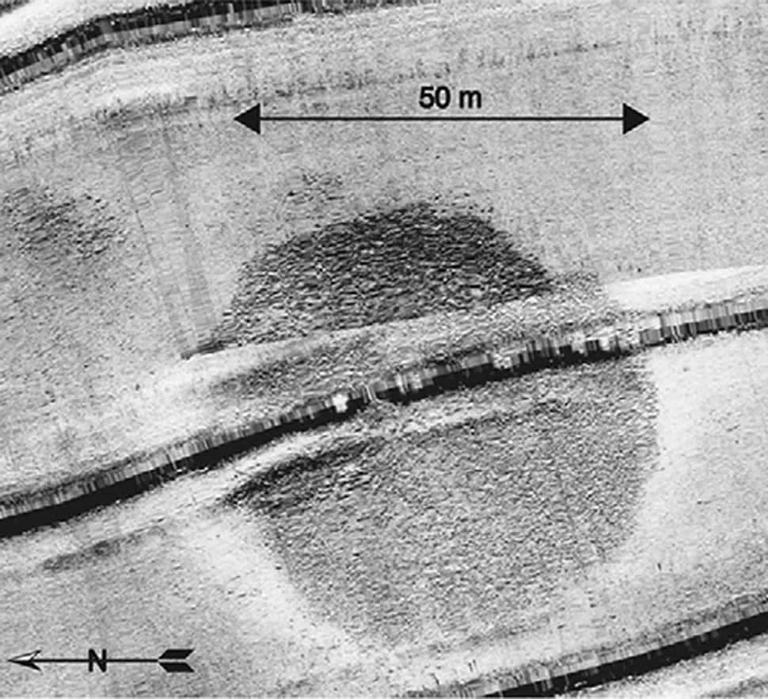
The structure was first detected during a 2003 sonar survey in the southwest part of the lake. Its cone-like shape and scale quickly drew attention, prompting further investigation by divers. Its proximity to known ancient sites has led scientists to explore possible links with early urban societies in the area.
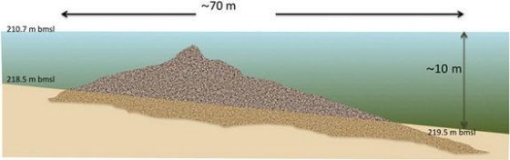
Putting all the data together researchers found that the structure is cone shaped, about 230 feet (70 meters) in diameter and nearly 32 feet (10 meters) tall. It weighs an estimated 60,000 tons.
Diagram courtesy of Shmuel Marco
A Massive Cairn Made of Unworked Stone
The structure rises nearly 10 meters (32 feet) high and spans approximately 70 meters (230 feet) in diameter. According to a press release published by the International Journal of Nautical Archaeology, it is composed of unhewn basalt cobbles and boulders, some measuring up to 1 meterin length. Divers reported no evidence of cutting or shaping. The stones appear randomly arranged, without walls or clear architectural patterns.
“The boulders have natural faces with no signs of cutting or chiselling. Similarly, we did not find any sign of arrangement or walls that delineate this structure.”
Researchers describe the structure as a cairn, a type of man-made pile of stones known from other regions and sometimes associated with burial practices, though no direct evidence confirms such a use here.
Evidence Suggests a Human-Made Origin
The structure does not resemble any natural geological formation. As explained by the research team, its shape and composition point clearly to human construction.
A Sonar Survey Of Part Of The Sea In The Summer Of 2003 First Detected The Circular Structure
They propose that it was built on dry land and later submerged as the Sea of Galilee expanded. This interpretation is consistent with known environmental changes affecting the region over thousands of years. The scale of the structure implies a high level of organization. In the researchers’ view:
Scientists Discovered A Mysterious Ancient City Hidden Underwater That Shouldn't Exist
“This is such a huge structure that it truly is something unusual. It could have been a big ceremonial structure, or a ramp. There could have once been statues on top of people in certain rituals. I mean, I’m really going wild here. The truth is we don’t know how it was constructed, what its exact age is, how it was used, or how long ago it was used. We have several speculations, but we don’t know much except that it’s there and it’s huge.”
A Lost Bronze Age Link
Archaeologist Yitzhak Paz, from the Israel Antiquities Authority and Ben-Gurion University, saidthat the stone structure may date to the third millennium B.C.. He noted that similar megalithic phenomena have been identified in nearby areas.
One example cited in the study is Khirbet Beteiha, located about 30 kilometers to the northeast, which features concentric stone circles. These parallels suggest the underwater structure could belong to the same cultural context.
If this dating is confirmed, the structure would have been located near Bet Yerah (or Khirbet Kerak), a major settlement of the time. ArchaeologistRaphael Greenberg noted that the city covered 30 hectares and had up to 5,000 inhabitants, with fortified defenses and organized urban planning.
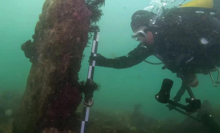
No underwater excavation has yet been carried out, leaving the structure’s function and exact age uncertain.
“If the site was inland, it would be much easier to investigate. By now we would have excavated, but because it’s submerged we haven’t yet been able to. It is a much harder process, both physically and financially. It is very expensive to raise support for such an enterprise,” noted Yitzhak Paz.
The Amarna Anomaly: Did Akhenaten’s DNA Carry the Signature of the Gods?
When Amenhotep IV ascended the throne in the 14th century BC, he was not meant to be king. The unexpected death of his older brother thrust him into power, and within a few short years, he changed his name to Akhenaten, meaning "effective for the Aten." He moved the capital to a new, isolated city in the desert, Akhetaten (modern Amarna), and declared himself the sole intermediary between humanity and the divine. Even today, researchers debate whether the ancient Egyptian Akhenaten plague may have been a historical myth designed to explain the sudden abandonment of this utopian city.
But it is the art of the Amarna period that has left the most indelible mark on history. Unlike the idealized, rigid, and muscular depictions of previous pharaohs, Akhenaten ordered his artisans to portray him and his family exactly as they were. The result was a shocking departure from tradition. Statues and reliefs show the pharaoh with a mix of masculine and feminine traits, including visible gynecomastia (breast tissue) and a distended belly. His wife, whose fate remains tied to the mysterious disappearance of Nefertiti and their daughters, was also depicted with dramatically elongated skulls.
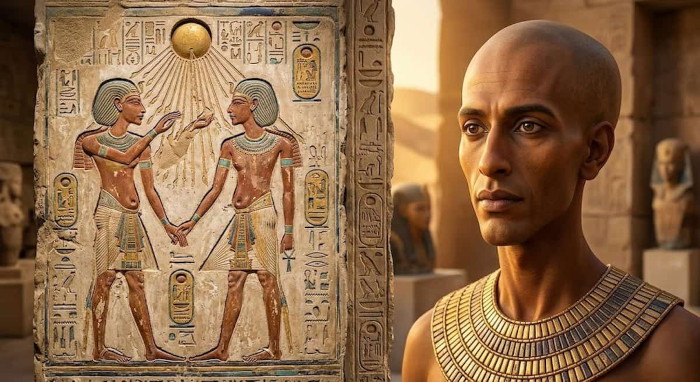
llustration of the more realistic art of the Amarna period.
According to a comprehensive 2025 medical review published in the Journal Cureus, experts have proposed numerous diagnoses to explain these features, ranging from Marfan syndrome to aromatase excess syndrome and Klinefelter syndrome. Marfan syndrome, a genetic disorder affecting connective tissue, could explain the elongated face and spindly limbs, but it does not account for the female characteristics. Conversely, aromatase excess syndrome could explain the gynecomastia, but it falls short of explaining the cranial deformities. The study ultimately concluded that while these medical theories are fascinating, it is highly unlikely that a single disease could account for the entirety of the Amarna royal family's bizarre physiques.
The Secret of Tomb KV55
The mystery deepened in 1907 when archaeologists discovered a small, unassuming tomb in the Valley of the Kings, designated KV55. Inside, they found a desecrated coffin. The golden face mask had been violently ripped away, and the cartouches bearing the occupant's name were chiseled out, a deliberate act of damnatio memoriae intended to erase the individual from the afterlife.
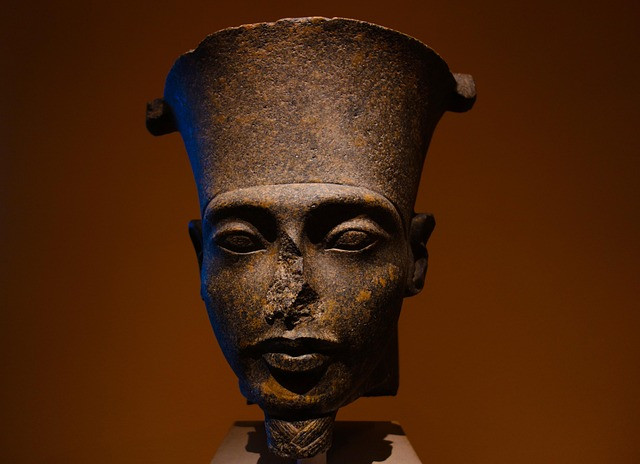
A striking close-up of a dark stone bust depicting Pharaoh Akhenaten, showcasing the distinctive elongated facial features and the tall crown of the 18th Dynasty.
For over a century, the identity of the KV55 mummy was fiercely debated. Was it Queen Tiye, the enigmatic Smenkhkare, or Akhenaten himself? In 2010, a landmark DNA study published in the Journal of the American Medical Association (JAMA) provided a stunning revelation. Genetic fingerprinting of the royal mummies confirmed that the KV55 skeleton was the father of King Tutankhamun and the son of Amenhotep III. By all genealogical accounts, this was the heretic king, Akhenaten, finally unmasking the identity of the controversial mummy KV55.
However, the physical examination of the KV55 skeleton presented a glaring paradox. The bones did not show the extreme deformities depicted in the Amarna art. There was no evidence of severe craniosynostosis (premature fusing of the skull bones) or the skeletal markers of Marfan syndrome. This has led many mainstream historians to conclude that the Amarna art style was purely symbolic, a propagandistic choice to depict the pharaoh as the "mother and father of all mankind," reflecting the androgynous nature of the Aten itself.
What if this conclusion is missing the larger picture? What if the art was not an exaggeration, but a deliberate homage to an ancestral truth that the pharaoh was trying to resurrect?
The Signature of the Gods
To understand the Amarna anomaly, one must look beyond the confines of traditional Egyptology and into the broader mythos of the ancient world. Across various ancient cultures, from the Sumerian texts of Mesopotamia to the biblical accounts of the Nephilim, there are persistent records of "Watchers" or "gods" who descended from the heavens and mingled their seed with humanity.
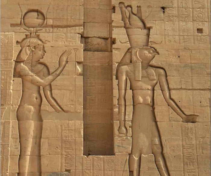
Ancient Egyptian relief at a temple complex, showcasing the monumental scale and detailed hieroglyphic carvings of the Amarna period.
Akhenaten’s religious revolution was not just about monotheism; it was about direct, unmediated contact with the divine. The Aten was not a human-like god; it was depicted as a celestial disc extending rays of light that ended in hands, offering the ankh (the breath of life) directly to the royal family. Akhenaten bypassed the traditional priesthoods because he claimed a direct, biological, and spiritual link to this celestial force.
If we view the Amarna period through the lens of ancient hybridization narratives, the physical anomalies of Akhenaten and his family take on a new meaning. The elongated skulls, the androgynous features, and the bizarre proportions may not have been the result of a random genetic disease, but rather the manifestation of a dormant, ancient gene, the biological blueprint of the "gods" from the First Time (Zep Tepi).
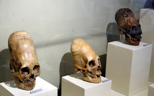
Elongated skulls on display at Museo Regional de Ica in the city of Ica in Peru.
This theory aligns with the global phenomenon of artificial cranial deformation, practiced by cultures from the Americas to the Black Sea. Why would disparate, unconnected ancient societies deliberately bind the heads of their infants to achieve an elongated shape? The most logical conclusion is that they were imitating a ruling elite or a "divine" race that naturally possessed these cranial features. Akhenaten and his daughters may have been the last visible resurgence of this authentic, un-deformed genetic lineage in the ancient Near East.
The Institutional Silence
The debate over Akhenaten’s DNA and his physical form is not just an academic exercise; it touches upon the sensitive issue of how history is curated. Just as the successor pharaohs, including Horemheb and even Akhenaten’s own son, Tutankhamun, systematically smashed the Amarna statues and erased the heretic’s name from the king lists, modern institutions have often been accused of downplaying discoveries that challenge the established narrative of human origins.
While there is no direct evidence of a modern "cover-up" regarding the KV55 mummy, the intense resistance within orthodox academia to entertain theories outside of standard medical diagnoses reflects a broader reluctance to engage with the uncomfortable anomalies of our past. The 2010 DNA results were groundbreaking, yet they left many questions unanswered, particularly regarding the exact nature of the genetic markers found within the 18th Dynasty lineage.
The Legacy of the Heretic
Akhenaten’s reign was a brief, blinding flash of radical departure in the long, conservative history of ancient Egypt. He attempted to pull his civilization back to a purer, more direct connection with the cosmos, bypassing the corrupt human institutions of the priesthood. In doing so, he may have revealed the true, hidden face of the ancient rulers, a face that was deliberately obscured by those who came after him.
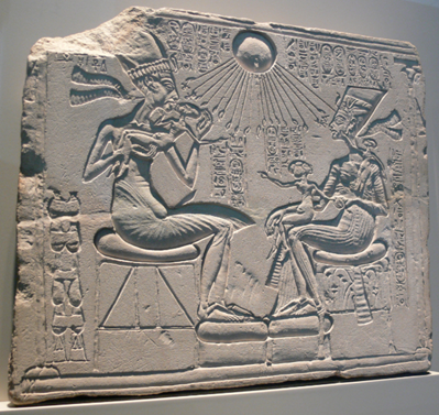
House altar Akhenaten Nefertiti Berlin showing Akhenaten, Nefertiti and three of their daughters. (Egyptian Museum of Berlin/Public domain)
The Amarna anomaly remains one of the most compelling mysteries of antiquity. Whether viewed as a tragic medical case study, an alternative view of the heretic king, or the startling re-emergence of a divine genetic blueprint, Akhenaten continues to challenge our understanding of who we are and where we came from. As science advances and our ability to sequence ancient DNA improves, the sands of Egypt may yet yield the final truth about the bloodline of the gods.
Deep Dive
The Global Elongated Skull Phenomenon: The practice of artificial cranial deformation was widespread in antiquity, from the Paracas skulls of Peru to the Huns of the Eurasian steppes. Many alternative researchers argue that this painful practice was an attempt by human elites to mimic the natural physiology of a "god-like" ruling class, of which the Amarna royals may have been a late manifestation.
The Damnatio Memoriae: The erasure of Akhenaten was so thorough that his existence was completely forgotten until the 19th century. His city of Akhetaten was abandoned and swallowed by the desert, preserving the unique art and boundary stelae that eventually allowed archaeologists to piece together the story of the pharaoh who tried to change the universe.
More Fast Facts
Medical Mystery or Divine Blueprint? The elongated skulls, spindly limbs, and androgynous features of Pharaoh Akhenaten and his family have baffled experts for over a century, with recent medical studies struggling to pinpoint a single human disease that explains all their physical anomalies.
The KV55 Controversy: DNA analysis from 2010 identified the desecrated mummy in Tomb KV55 as the likely father of Tutankhamun and the heretic king Akhenaten himself, but the lack of severe physical deformities in the skeleton has only deepened the mystery of the Amarna art style.
The golden sands of Egypt hold many secrets, but few are as enduring or as controversial as the mystery of the Amarna period. Over 3,300 years ago, a radical pharaoh upended seventeen centuries of religious tradition, plunging the most powerful empire in the ancient world into chaos. He abolished the powerful priesthoods, erased the names of the old gods, and established the worship of a single, faceless deity, the Aten. But it was not just his religious revolution that shocked subsequent generations; it was the bizarre, almost otherworldly physical appearance of the pharaoh himself.
Akhenaten, the "Heretic King," was depicted with a severely elongated skull, a long sinewy neck, a narrow upper torso, broad hips, and spindly limbs. For decades, Egyptologists and medical professionals have debated whether these depictions were mere artistic stylization or the result of a profound genetic mutation. Yet, as modern science attempts to retroactively diagnose this ancient ruler, a more profound question emerges: Could the physical anomalies of the Amarna royals be a reflection of a much older, divine bloodline, a genetic signature from the "first time" of the gods?
Israel’s strange Wheel of Ghosts, first discovered in 1968, turns out not to be so unusual after all, as new research combining remote sensing and AI now confirms the presence of many similar sites in the region.
Situated in the Golan Heights and composed of 40,000 tons of rock, archaeologists estimate the structure to date back between 3,500 and 6,500 years. Commonly referred to as the “Stonehenge of the East,” the site’s official name is Rujm el-Hiri, and it is cast in a decidedly new light in a recent paper published in PLOS One, revealing many similar structures.
Interpreting the Wheel of Ghosts
Existing interpretations have diverged in their explanations of what the Wheel of Ghosts meant to the people who built it. Those explanations run the gamut of what is generally assumed of these mysterious ancient sites: a ceremonial space, a burial mound, or an astronomical observatory.
However, these interpretations all relied on a major assumption that has proven false: that the Wheel of Ghosts is unique to the area.
That basic assumption has now been turned on its head by an international multidisciplinary team of physicists and archaeologists. Their work was rooted in remote sensing, a broad category of tools that have allowed archaeologists to view areas at broad scales, and even image beneath the ground. While such technologies have long existed, their increased adoption among archaeologists has led to major discoveries in the last two decades.
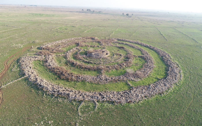
Newly discovered sites surrounding the Wheel of Ghosts maintained the round motif of the original. Credit: M. Birkenfeld
The Satellite View
Data for the research came from archives containing multiple satellite imagery platforms, including Google Earth Pro and CNES/Airbus. These archives held two decades of imagery captured between 2004 and 2024, providing multiple observations of the same regions over the years. Processing those images and then performing a comparative analysis helped the team to uncover these new sites.
Through AI processing, obscuring features like shadows and seasonal vegetation were mitigated, revealing features otherwise impossible to discern. These included signs of ancient human intervention, along with other notable landscape features, which were typically obscured. The team noted that this is a major boon to archaeology, alleviating the need for expensive, time-consuming expeditions to regions that may contain nothing of interest.
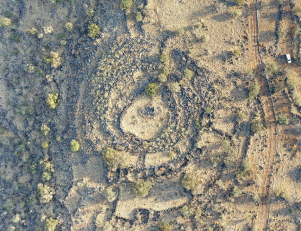
In the AI-processed imagery, researchers uncovered new sites resembling the wheel of Ghosts.
Credit: A. Kleiner
Uncovering Further Wheel of Ghosts-Like Sites
During their research, the team was shocked to find 28 sites resembling the Wheel of Ghosts, all of which had remained hidden in the area. These large, round structures shared many of the characteristics with Rujm El-Hiri and were all situated within a tight 16-mile radius of the site.
Amid the new discoveries, the Wheel of Ghosts remains singular in terms of its quality. Other sites were smaller, less elaborate, and more heavily degraded. This is likely why they remained undetected for almost six decades after the Wheel of Ghosts was first identified by modern archaeologists.
One of the primary impediments to clearly understanding the original site and these additional newly discovered structures is the broad time range archaeologists attribute to the original’s construction. This makes it difficult to determine exactly which group of people inhabited the area at the time, further clouding what these structures may have been intended for.
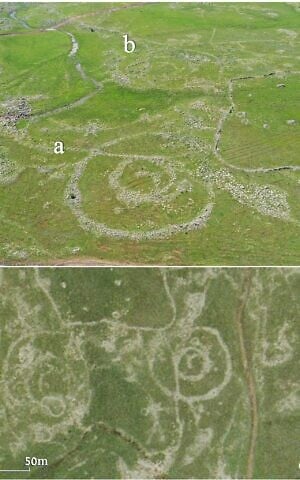
Aerial views of Circles 11(a) and 12 (b) identified in a survey conducted by remote sensing and published in the PLOS ONE journal on March 18, 2026. (Aerial imagery provided by the survey of Israel (MAPI)- used with permission. Upper photo by A. Wiegman. Prepared by M. Birkenfeld and U. Berger)
Intriguingly, while there seems to be a clear group of similar structures in this region, sites farther away in Galilee and Lebanon also resemble the Wheel of Ghosts in the new research. Tying together all of these sites, both near and far, will now require extensive on-the-ground research to determine if they were all occupied by a single culture
Ryan Whalen covers science and technology for The Debrief. He holds an MA in History and a Master of Library and Information Science with a certificate in Data Science. He can be contacted at ryan@thedebrief.org, and follow him on Twitter @mdntwvlf.
A discovery made more than two decades ago by Canadian marine engineers Paulina Zelitsky and Paul Weinzweig has resurfaced in recent discussions, sparking renewed interest and controversy. In 2001, while conducting an expedition to map the ocean floor near Cuba, the pair uncovered what they believed to be the remains of a long-lost city submerged over 2,000 feet underwater. The sonar scans revealed structures resembling pyramids, roads, and other buildings that suggested a sophisticated urban center. According to the DailyMail, this submerged city is believed to be more than 6,000 years old, potentially older than the Egyptian pyramids, and its discovery could reshape human history. However, since the initial findings, the site has been largely ignored, leaving many unanswered questions. The discovery has triggered debates about its authenticity, with experts divided on whether the site is a natural formation or evidence of an ancient civilization.
The Discovery: A Sunken City or Natural Formations?
When Zelitsky and Weinzweig first reported their findings, they described the structures as potential evidence of an advanced urban center that had been submerged beneath the sea over 6,000 years ago. The sonar scans revealed what appeared to be multiple pyramids and other carefully designed buildings. According to Zelitsky, “It’s a really wonderful structure which really looks like it could have been a large urban center.” With such a remarkable discovery, the team believed that the site could significantly alter our current understanding of human civilization.
However, the initial excitement soon gave way to skepticism from other scientists. One of the primary challenges to the authenticity of the discovery is the location itself: the structures are located over 2,000 feet underwater, far deeper than one might expect for a city that could have been submerged merely thousands of years ago. Skeptics argue that it would have taken much longer—possibly tens of thousands of years—for the area to sink to its current depth due to shifting tectonic plates.
“It would be totally irresponsible to say what it was before we have evidence,” Zelitsky added in a 2001 interview with the BBC, highlighting the complexity of interpreting the findings without more substantial data. Despite the initial reports, no follow-up research has been conducted to gather more concrete evidence to either confirm or debunk the theory that the site was an ancient city.
Sonar scans uncovered massive stone structures on the seabed near the Guanahacabibes Peninsula, resembling pyramids, circular formations, and large blocks.
Credit: ADC via Morien Institute.
Skepticism from Experts: Could the Structures Be Natural?
Among the loudest voices of skepticism is Cuban geologist Manuel Iturralde-Vinent, who has repeatedly dismissed the claim that the structures are man-made. “It’s strange, it’s weird; we’ve never seen something like this before, and we don’t have an explanation for it,” Iturralde told The Washington Post, acknowledging the unusual nature of the discovery, but also stressing the need for caution in interpreting the findings.
Iturralde and other experts have pointed out that the underwater formations could very well be the result of natural geological processes rather than the work of ancient civilizations. According to these critics, the regularity of the formations and their apparent symmetry could be coincidental, and not necessarily indicative of an artificial construction. Given the depth at which the ruins were found, some researchers suggest that the ocean currents and tectonic activity in the area might have shaped the stones in ways that mimic human-made structures.
The debate over the true nature of the site continues to rage, with some proposing that the discovery might be more evidence of ancient civilizations that were once lost to history, while others contend that the site is simply an odd but natural formation. The lack of conclusive evidence has led to an ongoing divide in the scientific community.
A Global Debate: Could This City Rewrite Human History?
While the mystery of the Cuban underwater city remains unsolved, it brings to the forefront one of the most intriguing questions in archaeology: How far back do human civilizations truly date? If the submerged ruins are indeed evidence of an ancient city, it could rewrite the conventional understanding of human history and civilization. Many believe that the discovery, if confirmed, would challenge the currently accepted timeline of human development, suggesting that advanced urban centers existed long before the Egyptians.
Michael Faught, a specialist in underwater archaeology at Florida State University, was among the experts expressing doubt about the authenticity of the ruins. “It would be cool if Zelitsky and Weinzweig were right, but it would be really advanced for anything we would see in the New World for that time frame. The structures are out of time and out of place,” Faught told the South Florida Sun-Sentinel, referencing the complexity of the structures that would have been unprecedented in the Americas at the time.
Despite these doubts, the possibility of rewriting human history remains an enticing prospect for many. Archaeological discoveries like Göbekli Tepe in Turkey, which predates the Egyptian pyramids by over 5,000 years, challenge our understanding of early human societies and their capabilities. Could the Cuban ruins be part of a similar, yet still undiscovered, civilization?
These two ancient civilizations were separated by thousands of kilometers.
Archaeologists report motifs in Honduras that resemble Neolithic Chinese symbolism, raising questions about deep shared roots rather than contact.
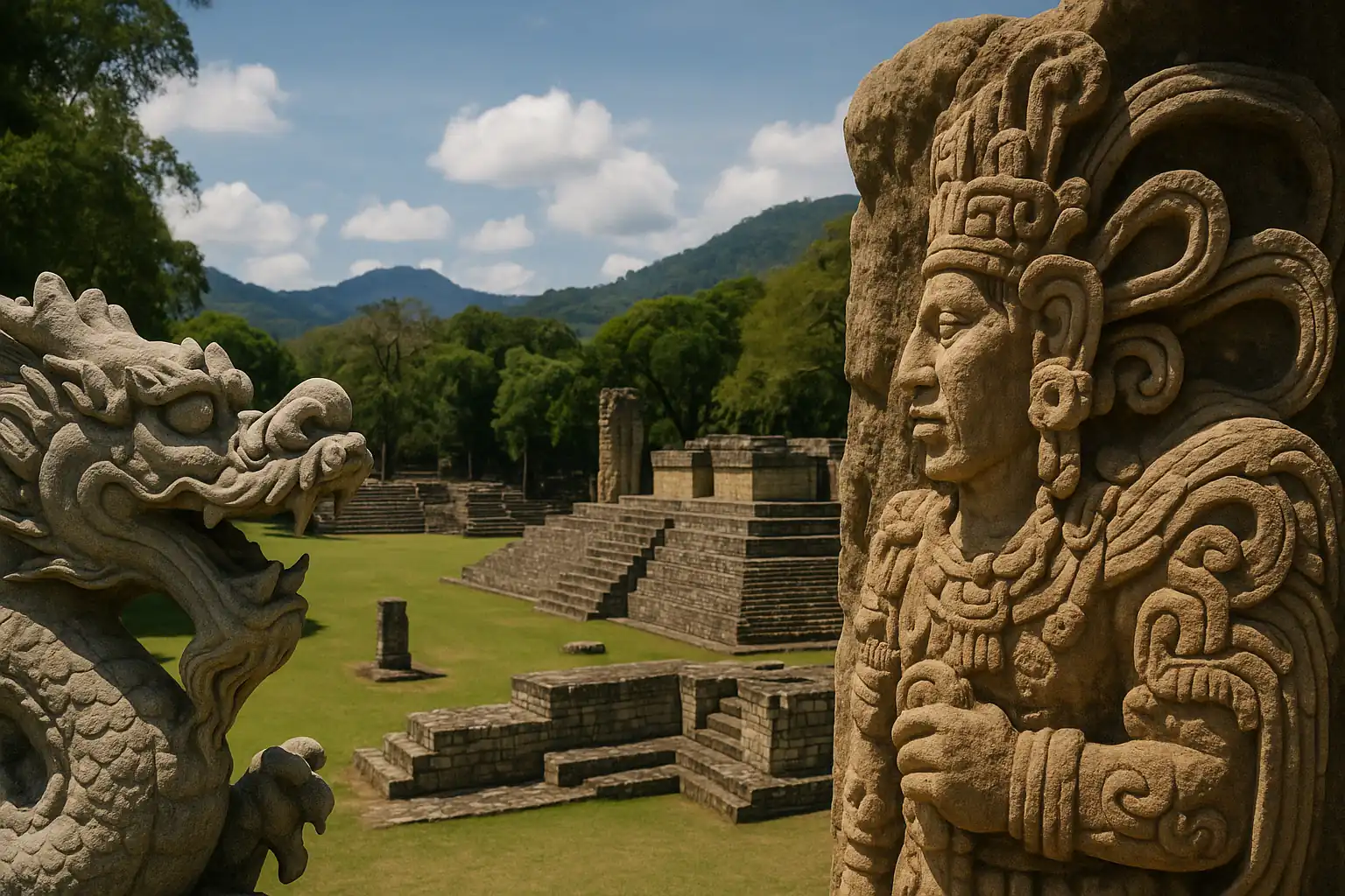
Archaeological work at Copán, the ancient Maya city in present-day Honduras, has revived an old debate about why distant civilizations sometimes produce familiar-looking symbols. A Chinese archaeological team working at the site has identified sculptures and architectural features that they say resemble elements associated with China’s Neolithic Liangzhu Culture.
The similarities have prompted renewed interest in whether shared ideas might have very deep origins, reaching back long before either civilization existed in its recognizable form. The claims, as described by researchers involved, are not framed as evidence that people crossed oceans to exchange beliefs or art. The argument is narrower and more speculative: that early human migrations and long-lived symbolic traditions could, in rare cases, leave faint echoes that surface in later civilizations separated by time and geography.
Motifs that look familiar across an ocean
Copán is known for dense, intricate stonework and a ceremonial landscape built to project authority. Within that setting, the team has pointed to decorative patterns and carved figures that it considers unusually close to motifs seen in Liangzhu material, especially in symbolic ornament and depictions of mythical creatures.
One of the main comparisons centers on the Maya feathered serpent deity Kukulkan and ancient Chinese dragon imagery. Supporters of the comparison note that both figures have long functioned as powerful symbols, often associated with sky, water, and divine authority. That overlap, they argue, makes the visual resemblance more than a coincidence of style.
Skeptics, however, caution that serpents, hybrid beings, and sky-linked divine animals are common across many cultures. Similar imagery can emerge independently when societies try to represent natural forces, political power, or religious authority in a memorable form. Without stronger connecting evidence, they argue, visual parallels risk becoming a collection of look-alikes rather than a meaningful historical pattern.
The debate is not new. What is new, supporters argue, is the attention generated by an active excavation program at a major Maya center and the willingness to frame the discussion around deep ancestry rather than direct borrowing.
The “China-Maya continuum” returns
The idea that China and the Maya world might share deep cultural roots has been discussed for decades, often under the label “China-Maya continuum,” a concept proposed in the 1980s by the Chinese-American archaeologist Kwang-Chih Chang.
Chang’s argument did not hinge on voyages or direct contact. Instead, he suggested that both cultural worlds might retain traces of older shamanistic traditions shaped by Paleolithic ancestors, long before the rise of cities, writing, or formal states. In that view, echoes of ritual life could persist in art, cosmology, and symbolic decoration even as societies developed independently.
That approach remains controversial. Comparative frameworks can clarify patterns, but they can also flatten differences, turning complex traditions into a few reusable shapes. Critics argue that resemblance is too often treated as explanation, when it should be the start of a harder question: why would a specific motif survive across such long spans of time, and what would count as evidence that it did?
Supporters reply that the point is not to claim an unbroken chain of transmission, but to consider whether certain symbolic structures are unusually persistent when passed through human migrations and reshaped in new environments.
Calendars and competing explanations
Researchers have also pointed to similarities in how both regions conceived of time. The Maya calendar, as described by archaeologists discussing the comparison, is said to show conceptual resemblances to the Chinese calendrical system organized around the 10 Heavenly Stems and 12 Earthly Branches.
The shared element in that comparison is a cyclical view of time. Both systems use repeating sequences that embed social meaning in calendars, linking timekeeping to ritual and authority. Proponents argue that a strongly cyclical structure is not universal in early civilizations and may reflect deeper cosmological assumptions about how the world is ordered.
Here again, the counterargument is straightforward: cycles are one of the most practical ways to organize time in agrarian and ritual societies. Seasonal rhythms, celestial repetition, and the social need to coordinate ceremonies all push communities toward cyclical frameworks. A shared logic does not require a shared origin.
Time & Calendars
The calendar comparison therefore sits in the same category as the iconographic one. It is suggestive to some, unconvincing to others, and difficult to adjudicate without clearer criteria for what counts as a meaningful match rather than a broad analogy.
Migration, not communication
Li Xinwei, identified as a lead archaeologist from the Chinese Academy of Social Sciences, has emphasized that there is still no evidence of direct contact between ancient China and the Maya world. In this account, the similarities are treated as the possible product of shared Paleolithic ancestry rather than any kind of later cultural diffusion across oceans.
The mechanism proposed is ancient migration. Early humans who moved from northern and eastern Asia into the Americas some 15,000 years ago, the argument goes, may have carried with them basic cultural traits: enduring symbols, oral traditions, and spiritual ideas that later evolved independently. Under that model, the resemblance would not come from one civilization influencing another, but from both drawing on a deep reservoir of inherited motifs that changed over time while retaining recognizable features.
Li’s position, as described, is that the evidence does not support borrowing and that the more plausible explanation is parallel development from common ancestral roots.
That distinction matters. Claims of contact imply ships, routes, exchange goods, and traceable movement of people and technologies. Claims of deep shared roots imply something less dramatic and harder to test: continuity through time, shaped by migration and long-term cultural evolution.
Why Copán matters
Copán’s prominence in the Maya world is part of why the argument draws attention. The city is known for its carved monuments and sophisticated ceremonial architecture, and it has often been described as the “Athens of the Maya world,” a reference to its artistic and intellectual reputation within the region.
The Chinese team has focused on a 4,000-square-meter residential complex that once housed local aristocracy. In that setting, it reports finding a large royal tomb and symbolic motifs such as crossed torches, imagery linked to Maya kingship. Researchers involved have also emphasized jade relics, depictions of the lightning god Kawiil, and regional building layouts as evidence of the site’s complexity and the elite culture that shaped it.
Those discoveries, taken on their own, fit comfortably within what is already known about Maya political and ritual life: elite residences, royal burials, dynastic symbolism, and the use of valuable materials like jade. The more contentious step is using selected motifs from those contexts to suggest a remote connection, however indirect, to symbolism known from Neolithic China.
What the similarities can and cannot show
The strongest version of the argument is modest. It does not require contact, and it does not claim that one civilization borrowed from the other. It proposes that certain ideas and images can endure in human cultures across great spans of time, even as they are transformed by new environments and new social systems.
The weaker version is the one critics worry about: that visual resemblance becomes a shortcut that substitutes for evidence. Similarity, in archaeology, is a starting point, not a conclusion. A convincing case typically requires patterns that are repeated, specific, and difficult to explain through shared human tendencies or basic constraints of representation.
In the account presented here, the proposed explanation remains a hypothesis rather than a demonstration. The comparisons may stimulate useful questions about how symbolism travels through time and how cultures converge on similar solutions. They may also overreach if they imply more certainty than the evidence can bear.
Li has also pointed to genetic research suggesting distant shared ancestry between populations in East Asia and the ancient peoples of the Americas, and has argued that this deep connection could help explain why two geographically isolated civilizations developed certain comparable features. The suggestion is that understanding how groups with common roots followed different paths, yet sometimes arrived at similar spiritual, architectural, and calendrical frameworks, could open a new line of inquiry in global ancient.
For now, the debate turns on an unresolved question that sits at the heart of comparative archaeology: when distant cultures look alike in specific ways, are we seeing inherited echoes from deep prehistory, or the predictable outcomes of human societies grappling with similar needs and similar imaginations in different places?
The discovery of ancient sea fossils atop several mountains around the world has reignited debate over the biblical story of Noah's Great Flood.
A viral video showing hikers uncovering fossilized seashells in the Guadalupe Mountains, a range stretching across west Texas and southeastern New Mexico, has fueled fresh speculation online that the towering peaks were once submerged beneath an ancient ocean.
The clip, which has been viewed more than seven million times, shows the group inspecting and collecting rocks, revealing embedded marine fossils such as bivalve seashells and other shellfish remnants.
The discovery has sparked a wave of debate online, with some viewers claiming the fossils are evidence of a global flood described in the Bible.
The Great Flood is portrayed in the Book of Genesis as a global catastrophe sent by God to wipe out widespread human corruption and violence.
According to the biblical account, Noah was instructed to build a massive ark to preserve his family and pairs of every animal species.
But geologists say the shells are remnants of ancient seabeds that were lifted thousands of feet into the air by tectonic forces over millions of years.
Marine fossils have been discovered on mountain ranges around the world, including the Himalayas, Andes and Rocky Mountains, which scientists say were once covered by ancient seas before being pushed upward as continents collided and mountains formed.
The viral video, shared in 2025, was taken by a group hiking in the Guadalupe Mountains, a range stretching across west Texas and southeastern New Mexico
The clip, which has been viewed more than seven million times, shows the group inspecting and collecting rocks, revealing embedded marine fossils such as bivalve seashells and other shellfish remnants
Despite the scientific explanation, the viral video triggered a flood of online reactions.
'[I] didn't need this discovery to believe in the great flood,' one user wrote on X.
'There have been discoveries all over the world that point to a great flood theory. It happened.' Another commenter declared: 'The Bible is accurate and true!'
However, many other users pushed back on the biblical interpretation, noting that marine fossils in mountains are a well-known geological phenomenon linked to the movement of tectonic plates.
Scientists explain that many rocks found in modern mountain ranges originally formed on the floors of ancient oceans, where marine creatures such as clams, corals and trilobites once lived.
When these animals died, their shells sank to the seabed and became buried in layers of sediment.
Over millions of years, the sediment hardened into rock, trapping the shells inside and turning them into fossils.
Later, the slow movement of Earth's tectonic plates pushed these ancient seabeds upward during massive continental collisions.
Several mountains, including a range in Italy, have been found to have fossilized sea life. The discovery has sparked a wave of debate online, with some viewers claiming the fossils are evidence of a global flood described in the Bible
As the plates crumpled and lifted the crust, the fossil-filled rocks were carried thousands of feet into the air, eventually forming mountain ranges.
The National Park Service explained that millions of years ago, much of what is now west Texas and southeastern New Mexico was covered by a shallow inland sea known as the Delaware Sea.
Marine animals such as clams, sea urchins and other shell-forming creatures lived in these waters, and when they died, their shells settled to the seabed and were preserved in layers of sediment that later hardened into rock.
Tens of millions of years later, powerful tectonic forces slowly pushed these ancient seabeds upward, lifting the fossil-filled rocks thousands of feet and forming what are now the Guadalupe Mountains.
Scientists say this process also explains why marine fossils can now be found high in places such as the Himalayas, the Andes and the Rocky Mountains, even though those regions were once located beneath ancient seas.
One of the most striking examples is found near the summit of Mount Everest.
Researchers have identified marine fossils embedded in a rock formation known as the Qomolangma Limestone near the world's highest peak.
The fossils, dating back roughly 450 million years, formed on the floor of the ancient Tethys Ocean before the collision of the Indian and Eurasian tectonic plates thrust the seabed upward to form the Himalayas.
Evidence of ancient oceans has also been uncovered high in the Andes Mountains of South America.
Geologists say the shells are remnants of ancient seabeds that were lifted thousands of feet into the air by tectonic forces over millions of years. Picutred is the Antequera in Spain
Fossils of prehistoric marine organisms have been found at several sites across the range, demonstrating that parts of the Andes were once submerged long before tectonic forces raised the mountains.
In North America, clues to a vanished sea can be found in the Rocky Mountains.
Much of the region was once covered by the Western Interior Seaway, a vast inland ocean that split the continent millions of years ago.
When the waters receded, they left behind layers of marine sediment and fossilized sea life that are still visible in the rock today.
The Appalachian Mountains, among the oldest ranges on Earth, also contain widespread marine fossils preserved in sedimentary rock layers.
These rocks hold the remains of ancient fish and other sea creatures from a time when large portions of the region were covered by prehistoric oceans.
Further west, marine fossils dating back roughly 300 million years have been discovered in New Mexico's Sangre de Cristo and Santa Fe mountain ranges.
Scientists have identified scallops and other ocean-dwelling organisms preserved in rock from the Pennsylvanian period, when shallow seas covered parts of the region.
Even Antarctica holds evidence of this dramatic transformation.
Marine fossils found in the Transantarctic Mountains suggest parts of the frozen continent once hosted ocean environments before massive shifts in Earth's crust reshaped the landscape.
Clues hidden in plain sight are reshaping its story. Across the quiet landscape of northeastern Louisiana, the sweeping ridges and towering mounds of Poverty Point rise with a presence that feels both deliberate and difficult to explain. For generations, archaeologists viewed the site as largely ceremonial, a place defined more by symbolism than daily life. Yet subtle clues buried in the soil have begun pointing toward a far more dynamic past. Patterns of movement, artifacts carried from distant regions, and the scale of construction hint at something larger unfolding here. As new research gathers momentum, the ancient earthworks appear less like silent monuments and more like the framework of an active human landscape.
1. Researchers now see gathering events shaping the ridges. Archeologists believe the concentric ridges supported large gatherings, according to the National Park Service. That possibility transforms the site from a quiet ceremonial zone into a dynamic place filled with people who traveled long distances. The scale begins to feel intentional because it fits the activity it may have once held. Travelers likely arrived with goods, stories and expectations that shaped the rhythm of the place.
Those repeated visits would have carved patterns into the land and created a shared identity linked to Poverty Point. The idea brings a lively pulse to a space once seen as still and symbolic.
2. Movement pathways appear built into the site’s design. Some researchers think the ridges guided how visitors moved, as reported by Smithsonian Magazine. The curved earthworks may have shaped footpaths that channeled people toward central areas. Once seen through that lens, the entire design becomes organized rather than mysterious. Walkways appear to sit quietly inside the broader landscape, waiting for someone to trace them again.
Such structure suggests the site functioned more like a coordinated gathering space than an empty monument. People may have followed predictable routes, creating a sense of flow that held the community together each time they returned to Poverty Point.
3. Massive community labor created the monumental mounds. Soil studies reveal that large communities helped build the mounds, as discovered by the Louisiana Office of State Parks. The work required immense cooperation and hints at a shared purpose that involved many groups. No single leader could have commanded labor on this scale without a unifying reason. That unifying force may have been gatherings, trade or seasonal events that encouraged participation.
This cooperative building effort suggests the site held meaning across broad regions. The sense of collective investment points to a place that functioned actively in the lives of those who constructed it, not a silent symbol removed from daily life.
4. Far reaching trade routes fed into Poverty Point’s economy. Artifacts found at the site originate from regions stretching from the Great Lakes to the Ohio River Valley. Items such as stone tools and copper pieces suggest people arrived carrying goods meant for exchange. These long distance connections give the site a wider influence than many expected and paint it as a major hub. Travelers may have returned because the location offered both opportunity and familiarity.
Trade would also explain why different groups were willing to invest effort into maintaining the site. A place that benefitted many people would naturally gather recurring attention and participation.
5. The central plaza likely hosted timed seasonal events. The massive open plaza appears flattened and maintained with great care. Researchers believe it may have supported events that followed seasonal patterns. Predictable gatherings could have guided travel and anchored cultural routines across many communities. People familiar with those cycles may have anticipated the journey each year and prepared for long trips to the site.
This kind of recurring schedule would create memories tied directly to the plaza. It becomes easier to imagine it filled with families, traders and visitors moving in sync with a rhythm that returned generation after generation.
6. The tallest mounds may have served as visual markers. Some scholars propose that the largest mounds operated as signals for travelers approaching from river routes. Their height and placement make them visible above the surrounding landscape, offering guidance to those arriving by water. That visibility gives the mounds a practical function beyond ceremony. They become landmarks meant to aid navigation across a region shaped by rivers.
Seeing them as markers makes the surrounding area feel more connected. Travelers could have relied on these reference points, making Poverty Point a familiar and welcoming destination even from far away.
7. Specialized activity areas reveal organized working zones. Excavations show clusters of tools and debris that suggest people worked in designated areas. These zones appear set apart from living or gathering spaces, hinting at intentional planning. Visitors may have crafted items, prepared supplies or exchanged goods in particular spots. Such organization points to a site designed to support different roles without chaos.
This separation of activity helps explain the impressive scale of the earthworks. A place that managed large groups needed order, and these areas show how that order may have been maintained by people who used the space regularly.
8. Shared meals created a sense of community identity. Food remains found throughout the site suggest many people ate together during gatherings. Bones, seeds and cooking residues show that meals were larger than simple subsistence activities. Shared eating often strengthens bonds, especially when groups reunite seasonally. These collective meals may have created traditions that tied people from distant regions to the same location.
That social unity helps explain why visitors returned. Meals shared across communities make a place feel familiar, weaving emotional ties into the land itself and anchoring Poverty Point deeper in cultural memory.
9. Water access points reveal careful planning for arrivals. The ridges near natural water sources suggest travelers accessed the site through predictable routes. People arriving by boat would have found convenient transitions from water to elevated ground. This layout indicates that the builders understood how movement worked across the region. Their planning made entry smooth, efficient and intuitive.
Such thoughtful design reinforces the idea that Poverty Point was built for repeated use. It may have been a dependable destination that generations trusted, knowing their arrival would be met with a landscape that welcomed them.
10. New interpretations reveal a site full of human motion. The emerging view of Poverty Point highlights people gathering, trading and working rather than standing in silent ceremony. The land carries the imprint of movement as much as construction. Travelers may have shaped the site as much as the builders did, adding layers of meaning each time they returned. The ridges and mounds feel less like rigid structures and more like traces of lives in motion.
Seeing the site this way brings warmth to its history. Poverty Point becomes a place built by many hands for many reasons, held together by shared purpose.
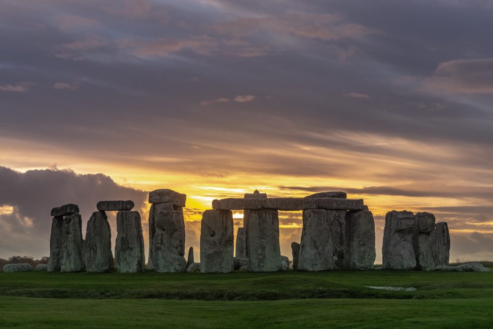
Stonehenge is arguably one of the most famous megalithic monuments in the world. It's also one of the most mysterious, with its prehistoric concentric rings garnering plenty of speculation as to why and how they were constructed.
It is indeed immensely picturesque. I can fancy sitting all a summer’s day watching its shadows shorten and lengthen again and drawing a delicious contrast between the world’s duration and the feeble span of individual experience. There is something in Stonehenge, almost reassuring. If you are disposed to feel that life is instead a superficial matter and that we soon get to the bottom of things, the immemorial gray pillars may serve to remind you of the enormous background of time.
Since 1977, visitors have been forbidden to touch or come close to the stones. There were cases of tourists damaging the monument. Since people are people and don’t really think at times, there have been occasions when tourists would chip the ancient stones to take home a souvenir from the site. The ruins are in a delicate condition, and touching the stones could be detrimental to preserving this ancient monument.
Did Aliens build Stonehenge?
Several theories have been proposed throughout the years, and some are truly bizarre. Legends say mighty wizards positioned the stones, and some believe aliens had something to do with Stonehenge. It probably wasn’t aliens, and neither did wizards have something to do with Stonehenge, but we still have absolutely no clue how–and why–the stones were transported from such great distances. Famous Swiss author Erich von Däniken believed that he cracked the code in 1968 when he published his book Chariots of the Gods. In his book, he claims that Aliens built Stonehenge. Many people still believe in Von Däniken’s theory, but most of it is dismissed as pseudoscience.
Survival of Biblical Flood
Many theories are roaming around regarding Stonehenge, but one is very interesting. Henry Browne wrote it in the first guidebook in 1823. Henry Browne claims that Stonehenge is one of the monuments that has survived the Biblical Flood. He believes that Stonehenge was finished with construction around the same time as Flood has occurred. There is no real evidence to support this claim, but it is an interesting subject for further discussion.
Stonehenge; a work of Merlin
There is a theory by Geoffrey of Monmouth, who made chronicles of King Arthur legends. He states that the great Wizard Merlin airlifted the stones from Country Kildare in Ireland and placed them on Salisbury Plain as a memorial to the Britons’ massacre. To a modern audience, Geoffrey’s story sounds crazy, but they had no way of explaining or understanding how the stones stood upright in the Middle Ages. In the past, magic was the only real explanation for the creation of Stonehenge.
Stonehenge and Druids.
Legend says that Druids built Stonehenge as a place of worship, and it does seem like whoever built it, and he had help from some magic. Religion was brought to the British Isles by Ancient Celtics priests, who came here 3000 years after Stonehenge was built. Although the Druids in ancient times did not see Stonehenge as a place of worship, modern Druids and neo-pagans considered the site sacred. The exact age of Stonehenge is a mystery, and its age is something we should ponder about.
Stonehenge as Astronomical Tool
Ancient people used Stonehenge for Astronomical purposes as the alignment of Stonehenge stones with astronomical events is extraordinary. Stonehenge faces the northeast, and each stone is diligently placed to track the sun’s movement. Great attention was given to the solstices and equinoxes, which would have been crucial times on the prehistoric calendar. These days would mark the growing and harvest seasons and would have meant life or death for the people. Astroarchaeologists even suspect that the winter solstice would have been more important to people, as it marked the coldest and darkest day, meaning warmth and the growing season were coming.
Stonehenge as Ancient Concert Venue
Archeologists, explorers, and tourists have speculated about the purpose of Stonehenge for centuries. Aside from the usual burial ground and religious temple theories, it is believed it may have had a musical connection. Tourists have reported sounds emanating from Stonehenge, so there might be some truth in it. Dr. Rupert Till believes if Stonehenge weren’t ruined now, the sounds would be amplified by stones. Stonehenge’s bluestones carry a distinctive echo, suggesting that people knew this and specifically sought out the stones.
Stonehenge Was Built In Phases
The old saying, “Rome wasn’t built in a day” can also be applied to Stonehenge, as the British monument was built in various stages. From the Neolithic Period to Bronze Age, the construction of Stonehenge came in phases. Stonehenge’s circular enclosure (believed to contain bluestones in the past) is the oldest part, dug around 3000 BCE. The massive sarsen stones were brought to the site 500 years later and stood upright to form the trilithons, including the structure we know today. But there were still four more stages of construction after the central monument was complete.
Old As The Pyramids
People think of the Pyramids as the oldest prehistoric monument, but history has proved that Stonehenge is just as ancient as the Egyptian Pyramids. The Great Pyramid of Giza was built around 2500 BCE. The time needed to build one pyramid was around 20 years. Meanwhile, in old Britain, ancient tribes were busy building and erecting the stone circle at Stonehenge. The ancient circle surrounding the henge was built some 500 years earlier, and there are many indications that there was a previous structure at the site of the current henge.
More than a Henge
Stonehenge is just one part of a broader sacred landscape that contains many other stones and wooden structures and burials. Part of the site is the henge at Avebury, a much larger stone monument, though somewhat less impressive due to its lack of massive trilithons.
Archaeologists have also found evidence of widespread prehistoric hunting and a road that may have led to Stonehenge. From what scientists can tell, Salisbury Plain was considered a sacred area long before Stonehenge was constructed. It was known 10,500 years ago three large pine posts, which were totem poles of sorts, were erected at the site. (Rephrase this too) What was known 10,500 years ago?
Meer van UFO'S of UAP'S, ASTRONOMIE, RUIMTEVAART, ARCHEOLOGIE, OUDHEIDKUNDE, SF-SNUFJES EN ANDERE ESOTERISCHE WETENSCHAPPEN - DE ALLERLAATSTE NIEUWTJES


 Israel's Stonehenge No Longer Alone: Dozens of Stone Circles Discovered