Naar de inhoud

UFO'S of UAP'S, ASTRONOMIE, RUIMTEVAART, ARCHEOLOGIE, OUDHEIDKUNDE, SF-SNUFJES EN ANDERE ESOTERISCHE WETENSCHAPPEN - DE ALLERLAATSTE NIEUWTJES

UFO's of UAP'S in België en de rest van de wereld
akke.beakke.be
Ontdek de Fascinerende Wereld van UFO's en UAP's: Jouw Bron voor Onthullende Informatie! Ben jij ook gefascineerd door het onbekende? Wil je meer weten over UFO's en UAP's, niet alleen in België, maar over de hele wereld? Dan ben je op de juiste plek! België: Het Kloppend Hart van UFO-onderzoek In België is BUFON (Belgisch UFO-Netwerk) dé autoriteit op het gebied van UFO-onderzoek. Voor betrouwbare en objectieve informatie over deze intrigerende fenomenen, bezoek je zeker onze Facebook-pagina en deze blog. Maar dat is nog niet alles! Ontdek ook het Belgisch UFO-meldpunt en Caelestia, twee organisaties die diepgaand onderzoek verrichten, al zijn ze soms kritisch of sceptisch. Nederland: Een Schat aan Informatie Voor onze Nederlandse buren is er de schitterende website www.ufowijzer.nl, beheerd door Paul Harmans. Deze site biedt een schat aan informatie en artikelen die je niet wilt missen! Internationaal: MUFON - De Wereldwijde Autoriteit Neem ook een kijkje bij MUFON (Mutual UFO Network Inc.), een gerenommeerde Amerikaanse UFO-vereniging met afdelingen in de VS en wereldwijd. MUFON is toegewijd aan de wetenschappelijke en analytische studie van het UFO-fenomeen, en hun maandelijkse tijdschrift, The MUFON UFO-Journal, is een must-read voor elke UFO-enthousiasteling. Bezoek hun website op www.mufon.com voor meer informatie. Samenwerking en Toekomstvisie Sinds 1 februari 2020 is Pieter niet alleen ex-president van BUFON, maar ook de voormalige nationale directeur van MUFON in Vlaanderen en Nederland. Dit creëert een sterke samenwerking met de Franse MUFON Reseau MUFON/EUROP, wat ons in staat stelt om nog meer waardevolle inzichten te delen. Let op: Nepprofielen en Nieuwe Groeperingen Pas op voor een nieuwe groepering die zich ook BUFON noemt, maar geen enkele connectie heeft met onze gevestigde organisatie. Hoewel zij de naam geregistreerd hebben, kunnen ze het rijke verleden en de expertise van onze groep niet evenaren. We wensen hen veel succes, maar we blijven de autoriteit in UFO-onderzoek! Blijf Op De Hoogte! Wil jij de laatste nieuwtjes over UFO's, ruimtevaart, archeologie, en meer? Volg ons dan en duik samen met ons in de fascinerende wereld van het onbekende! Sluit je aan bij de gemeenschap van nieuwsgierige geesten die net als jij verlangen naar antwoorden en avonturen in de sterren! Heb je vragen of wil je meer weten? Aarzel dan niet om contact met ons op te nemen! Samen ontrafelen we het mysterie van de lucht en daarbuiten.

Categorie: ARCHEOLOGIE ( E, Nl, Fr )

Scans reveal mysterious buried structure near Great Pyramid

Scans reveal mysterious buried structure near Great Pyramid

Scans reveal mysterious buried structure near Great Pyramid

©Getty Images

Scans reveal mysterious buried structure near Great Pyramid

Hidden Giza anomaly: A 2024 survey revealed an L-shaped structure and deeper resistive feature beneath the Western Cemetery near the Great Pyramid.

Advanced scanning tools: Researchers used ground-penetrating radar and electrical resistivity tomography to map subsurface shapes without excavation.

Unresolved mystery: The anomalies may be archaeological but their purpose and composition remain unknown until further investigation.

References

Use of advanced remote-sensing technologies in archaeological and climate research

©NECROPOLIS OF SAQQARA, GIZA, EGYPT -- MARCH 9, 2020: Maxar overview satellite imagery of the Necropolis of Saqqara. Please use: Satellite Image (c) 2022 Maxar Technologies.

Use of advanced remote-sensing technologies in archaeological and climate research
Advanced remote-sensing technologies have enabled the detection of hidden archaeological structures and ancient environmental features. These tools allow researchers to uncover landscapes and artifacts that are invisible to traditional field surveys. The approach is reshaping narratives about ancient environments and civilizations.

References

Location of the Underground Structure on the Giza Plateau

©Photo by Mohamed El Raai/Anadolu Agency/Getty Images. GIZA, EGYPT - AUGUST 31: Egyptian archeologists and Waseda Universtiy's archeologists research the ruins of 2nd full-size vessel, which is predicted to be belonging to Pharaoh Khufu's era, at Pyramids region in Giza, Egypt on August 31, 2016.

(Photo by Mohamed El Raai/Anadolu Agency/Getty Images)

Location of the Underground Structure on the Giza Plateau

The newly discovered underground structure is situated on the Giza Plateau, an area that has been extensively studied for decades. Its presence in such a well-documented archaeological zone underscores the potential for significant undiscovered features even in heavily researched sites.

References

2024 Archaeological Prospection paper documents Giza anomalies

©Photo by Ali Moustafa/Getty Images. GIZA, EGYPT - NOVEMBER 7:A general view of the Pyramid of Menkaure at the Giza Pyramids necropolis in Giza on November 7, 2025 in Giza, Egypt.

(Photo by Ali Moustafa/Getty Images)

2024 Archaeological Prospection paper documents Giza anomalies

L-shaped structure discovered beneath Western Cemetery near Great Pyramid

©Photo by mark peterson/Corbis via Getty Images. Cemetery near Pyramids of Giza

(Photo by mark peterson/Corbis via Getty Images)

L-shaped structure discovered beneath Western Cemetery near Great Pyramid
A 2024 peer-reviewed survey identified an L-shaped structure located approximately 6.5 feet below the surface in the Western Cemetery area near the Great Pyramid. The structure's sharp geometric form suggests it is not a natural formation. Its precise shape and shallow depth indicate it may be of archaeological significance.

References

Underground Structure Discovered Near the Great Pyramid

©Photo by Ali Moustafa/Getty Images. GIZA, EGYPT - NOVEMBER 7: A general view of the Great Pyramid of Khufu at the Giza Pyramids necropolis in Giza on November 7, 2025 in Giza, Egypt.

(Photo by Ali Moustafa/Getty Images)

Underground Structure Discovered Near the Great Pyramid
Archaeologists have identified a mysterious underground structure buried beneath the sand in close proximity to the Great Pyramid. The nature and purpose of this structure remain unknown, and it has not been previously documented despite the extensive study of the Giza Plateau.

References

Lack of excavation confirmation for Giza anomalies

©Photo by Hulton-Deutsch Collection/CORBIS/Corbis via Getty Images. (Original Caption) Great Pyramid.

(Photo by © Hulton-Deutsch Collection/CORBIS/Corbis via Getty Images)

Lack of excavation confirmation for Giza anomalies
Researchers note that no excavation has been conducted to confirm the nature of the anomalies detected near the Great Pyramid. The available data is limited, and interpretations remain unverified by direct archaeological investigation.

References

No follow-up excavation reported for Giza anomalies

©Photo by Archive Photos/Archive Photos/Getty Images. A view of the Great Pyramid of Giza Egypt.

(Photo by Archive Photos/Archive Photos/Getty Images)

No follow-up excavation reported for Giza anomalies
Despite the detection of underground anomalies near the Great Pyramid in 2024, there have been no reported follow-up excavations to investigate the findings further.

References

Satellite radar mapping reveals buried river channels in Sahara Desert

©Photo by Universal History Archive/Getty Images. UNSPECIFIED - CIRCA 1754: Sahara Desert (satellite image)

(Photo by Universal History Archive/Getty Images)

Satellite radar mapping reveals buried river channels in Sahara Desert
Satellite radar surveys have identified buried river channels across the Sahara Desert. These channels are evidence of past hydrological systems that existed beneath the current desert surface.

References

{ https://www.bing.com/ck/ }

Hoe vind je dit bericht?
Geschreven door peter om 23:17 Stuur door

Archaeologists Found an ‘Anomaly’ Near the Pyramids That May Reveal an Ancient Portal

https:%2F%2Fmedia.zenfs.com%2Fen%2Fpopular_mechanics_642%2F7ff52ff30f0d0a60f3c224e88c8d2b54

Experts Find 'Anomaly' Near the Great Pyramids

Nick Brundle Photography - Getty Images

Ground-penetrating radar has enabled archaeologists to identify hidden structures beneath the surface. A new study conducted by Japanese and Egyptian researchers has revealed an L-shaped structure accompanied by a nearby anomaly next to the Great Pyramids of Giza. While the precise nature of the anomaly is unknown, the researchers speculate that the L-shaped feature could potentially be an entrance to a deeper structure.

In archaeology, ground-penetrating radar (GPR) has transformed the way sites are studied. This geophysical technique sends radar pulses into the ground to create subsurface images. Similar methods have previously uncovered Viking longships in Norway, revealed lost civilizations within the Amazon rainforest, and even mapped entire Roman cities without any excavation.

Once again, GPR has yielded discoveries near one of the world’s most thoroughly explored sites—the Great Pyramids of Giza. The research team, led by Motoyuki Sato of Tohoku University, combined GPR with electrical resistivity tomography (ERT), a method that uses variations in electrical resistance to map underground features. Using these techniques, they detected what they describe as an “L-shaped anomaly” in the western cemetery close to the pyramids.

Darren Orf

In the world of archeology, few tools have revolutionized the field as much as ground-penetrating radar (GPR). This geophysical technique uses radar pulses to image the subsurface. Similar techniques have uncovered Viking longships in Norway, revealed lost civilizations in the Amazonian jungle, and even entire Roman cities without ever putting a shovel into dirt.

In 2024, GPR once again delivered near one of the most well-excavated sites in the world—the Great Pyramids of Giza.

Researchers led by Tohoku University's Motoyuki Sato used GPR, along with electrical resistivity tomography, or ERT, to survey a "blank" patch of the Western Cemetery, the elite burial zone west of the Great Pyramid. The scans showed an L-shaped structure near the surface, with a deeper anomaly below it.

GPR sends radar pulses into the ground. ERT maps how strongly buried materials resist electrical current. Together, the methods gave the team a look at shapes and contrasts below the sand without opening the ground.

According to the team's research paper, published in the journal Archeological Prospection, the structure is roughly 6.5 feet from the surface, measures 33 feet in length, and was backfilled after construction.

"The Western Cemetery at Giza is known as an important burial place of members of the royal family and high-class officers," the paper reads. "In the initial survey by GPR and ERT we found an anomaly in the north of the survey site. The area of the anomaly could be established approximately, but the structure and the location were unclear."

Below the L-shaped feature, the team reported a deeper anomaly 16 to 33 feet underground and described it as "highly electrically resistive." That could mean a few things. The paper pointed to two possibilities: a mixture of sand and gravel, or sparse spacing with air voids. The cemetery around it is packed with mastabas, the flat-roofed tombs associated with elite burials at Giza. This particular patch drew less attention because it did not have the kind of visible surface architecture that usually pulls archaeologists in.

Later research and heritage-science literature treats the 2024 paper as an example of integrated GPR/ERT work in Egypt, but the Western Cemetery anomaly has not been upgraded into a solved archaeological case.

So, what exactly could this L-shape structure and its lower anomaly represent? Speaking with Live Science, Sato said the structure is likely not natural, as the shape is too sharp.

"It may have been an entrance to the deeper structure," Sato and his colleagues wrote in the paper. But "may" is doing real work here. The scan doesn't identify what is below the L-shaped feature, and the researchers didn't claim they had found a tomb. "From the survey results, we cannot determine the material causing the anomaly," they wrote, "but it may be a large subsurface archaeological structure."

The paper called for excavation to establish the anomaly's purpose. Until that happens publicly, the cleanest version of the story is that something unusual showed up in the scans beside the Great Pyramid, and archaeologists still don't know exactly what it is.

This Western Cemetery study is separate from viral claims about enormous hidden structures beneath the Pyramid of Khafre, which Egyptian archaeologist Zahi Hawass publicly rejected in 2025. The GPR/ERT study near the Great Pyramid is peer-reviewed and real—but it's also unresolved.

RELATED


Archaeologists Discovered Mysterious Technology in a Forgotten Pyram

Great Pyramid Anomaly Makes No Sense!

The Missing Logbook That Proves Pyramids Weren't Built With Ropes

{ https://www.popularmechanics.com/science/ }

Hoe vind je dit bericht?
Geschreven door peter om 17:32 Stuur door

“It Was Completely Shocking to Me”: Archaeologists Discover the Earliest Monumental Egyptian Hieroglyphs Written 1,000 Years Before the Pyramids

Image by chuju_lin from Pixabay

“It Was Completely Shocking to Me”: Archaeologists Discover the Earliest Monumental Egyptian Hieroglyphs Written 1,000 Years Before the Pyramids

A joint expedition to the ancient Egyptian city of Elkab has unearthed several previously unknown ancient rock art inscriptions, including what the team believes are the earliest known monumental Egyptian hieroglyphs.

Written over 1,000 years before the Great Pyramid of Giza was constructed, these ancient Egyptian writings, discovered by archaeologists from Yale University and the Royal Museums of Art and History (Brussels), laid the foundation for the later, better-known hieroglyphic writing system.

Yale Professor John Coleman Darnell, the expedition’s leader and the co-director of the Elkab Desert Survey Project, said the newly discovered inscriptions, which were not recorded by any previous scientific expedition, include samples as far back as 4,000 BCE.

Although the team concedes that these are not the first examples of this specific style of rock art, they are the first of this ancient age and “monumental” scale, making them of great significance in the history of ancient Egyptian writing systems.

“This was not what I was expecting to find when I set out on this period of work on the expedition,” Professor Darnell said of the historic find. “It was completely shocking to me.”

Earliest Monumental Egyptian Hieroglyphs Depict Cosmological Concepts

In a Yale news story announcing the discovery, Professor Darnell noted that the newly discovered rock art site of El-Khawy preserved some of the earliest and largest signs “from the formative stages of the hieroglyphic script.” The professor added that the discovery includes “rare” evidence for how this enigmatic ancient society invented its internationally recognized ancient writing system.

The expedition, which was directed by Darnell and Dirk Huyge, was undertaken in cooperation with the Ministry of Antiquities and the Aswan and Edfu inspectorates.

After photographing the newly discovered inscription, Darnell and Alberto Urcia, a digital archaeologist and associate research scientist in the University’s Department of Near Eastern Languages and Civilizations, created a series of three-dimensional (3D) images. Darnell said the new technology allows archaeologists to record ancient sites and artworks “at a level of accuracy and detail that was absolutely impossible before.”

“It also means that we can record the site as a place, or a location, and not just as a series of inscriptions,” the professor added.

ancient writing, Earliest Egyptian hieroglyphs The newly discovered panel of signs features images of a bull’s head on a short pole followed by two back-to-back saddlebill storks with a bald ibis bird above and between them. This arrangement of symbols is common in later Egyptian representations of the solar cycle and with the concept of luminosity. Image Credit: Yale University, Royal Museums of Art and History (Brussels).

One of the more noteworthy examples of ancient monumental hieroglyphs, carved sometime between 4,000 and 3,500 BCE, depicted a herd of elephants. A closer examination also revealed that one of the elephants had an image of a smaller elephant inside of it, which Professor Darnell described as “an incredibly rare way of representing a pregnant female animal.”

A second discovery detailed by the joint expedition, which consists of four separate panels, was likely created sometime around 3,250 BCE. Written right to left, which ultimately became the dominant writing form in later Egyptian hieroglyphic languages, the panels show animal images of a bull’s head on a short pole, followed by two back-to-back saddlebill storks with a bald ‘ibis’ bird above and between them.

The research team said this arrangement of symbols is common in Egyptian representations created centuries after the newly discovered panels depicting the solar cycle. These same depictions typically include imagery of luminosity. Darnell suggested that the images may also express “the concept of royal authority over the ordered cosmos.”

“This is the First Time That Anyone Has Seen Them on Such a Massive Scale”

When discussing the importance of the new find, Professor Darnell noted the immense size of the individual tableaus and their elements. For example, each individual hieroglyph identified by the Yale-led team measures over half a meter in height. The professor also noted that the entire tableau “is about 70 centimeters (27.5 inches) in height,” whereas previously discovered signs of early Egyptian hieroglyphs were “only one or two centimeters in size.”

“This discovery isn’t new in the sense that this is the first time that anyone has seen these hieroglyphs,” Darnell explained, “this is the first time that anyone has seen them on such a massive scale.”

To offer a perspective on the discovery’s significance, the professor said a modern-world equivalent would be seeing smaller text displayed on your computer screen, “and then suddenly seeing very large ones made the same way,” only displayed up on a highway billboard.

When discussing the site’s location in the northeastern desert hinterland of Elkab, Darnell noted that it was a “very important” center in ancient Egypt, which demonstrates that the area’s budding communicative system “is not limited to the more commonly found small tokens or labels.”

The professor also said the study shows that ancient writing did not develop slowly “for bureaucratic use,” as researchers had previously believed. Instead, Darnell suggested that the discovery shows hieroglyphic-style writing “was more geographically widespread and topically diverse at the time of or shortly after its development.”

“This also suggests that there is a much more expansive use of the early writing system than is indicated from other surviving archaeological material,” the professor added.

  • Christopher Plain is a Science Fiction and Fantasy novelist and Head Science Writer at The Debrief. Follow and connect with him on X, learn about his books at plainfiction.com, or email him directly at christopher@thedebrief.org.
RELATED VIDEOS

These Hieroglyphs Finally Reveal How Ancient Egyptians Cut Granite — And The Machine They Actually


The Hieroglyphs Describe Structures That Existed Before Egypt — And What They Left Buried …


These Hieroglyphs Reveal How The Pyramid Stones Were Actually Lifted — And The Device They Used


These Hieroglyphs Describe Giants The Pharaohs Tried To Destroy — And Why They Couldn't Be Killed

{ https://thedebrief.org/category/science/ }

Hoe vind je dit bericht?
Geschreven door peter om 00:34 Stuur door

5,000-Year-Old ‘Prototype’ for Stonehenge Solar Alignment Discovered

5,000-Year-Old ‘Prototype’ for Stonehenge Solar Alignment Discovered

Stonehenge Sunset

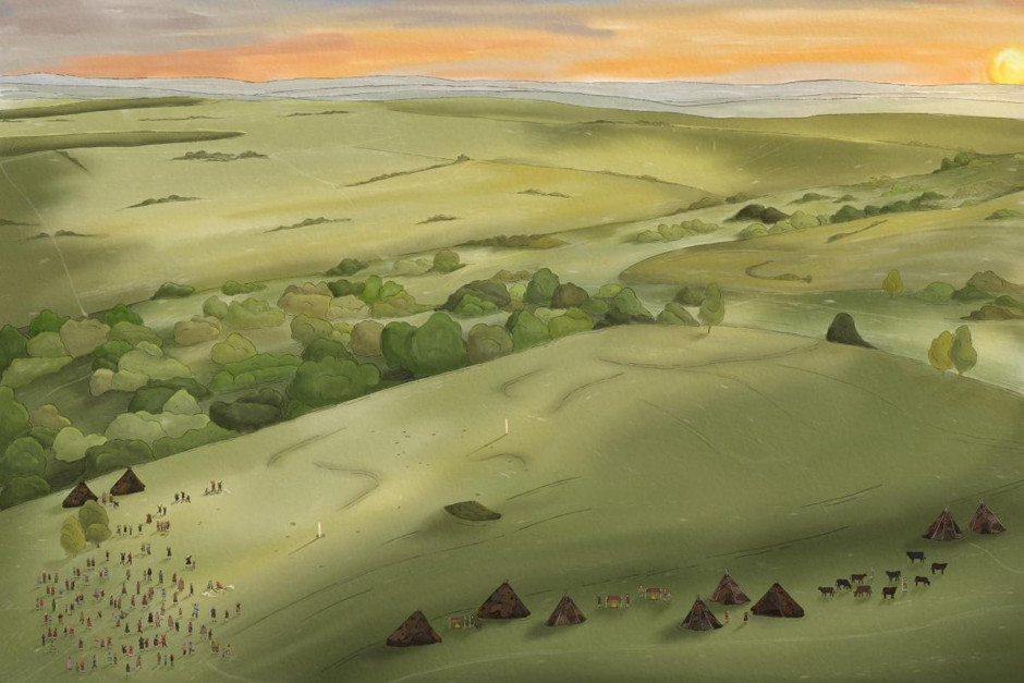
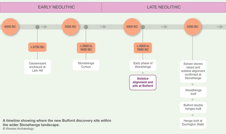
As thousands prepare to flock to Stonehenge ahead of summer solstice celebrations this weekend, a team from Wessex Archaeology led by Phil Harding has announced the discovery of an ancient structure that may have served as an early ‘prototype’ for the alignment with the solstice at Stonehenge. Radiocarbon dated to around 5,000 years ago, the discovery reveals evidence for the earliest known alignment with the solstice in the Stonehenge landscape, showing that ancient people were using this feat of astronomical engineering to celebrate the solstice here at least 500 years before the alignment of the stones at Stonehenge.

Located 5km (3.1 miles) from Stonehenge in Bulford, Wiltshire, the site is contemporary with the earliest phase of Stonehenge when the first earthworks were built. Excavated as part of the Ministry of Defence’s Army Basing Programme, the site was likely a focus for major religious gatherings, with extensive evidence of feasting and large-scale gatherings as people came together to celebrate the solstices much as they still do today at Stonehenge.

A reconstruction of summer solstice celebrations as they might have appeared at Bulford 5000 years ago

A reconstruction of summer solstice celebrations as they might have appeared at Bulford 5000 years ago

(Wessex Archaeology)

A Solstice Alignment Prototype

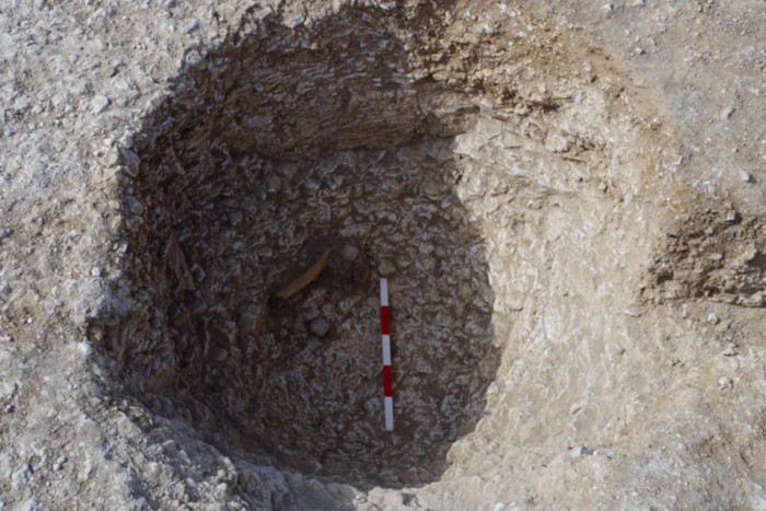
The structure at the heart of the discovery would have consisted of two wooden poles 120 meters apart, which ancient builders positioned to form a line pointing directly at the rising sun during the summer solstice and at the setting sun during winter solstice. Little is now left of the structure except the pits in which the poles once stood, which are not accessible to the public, but their alignment with the solstice was confirmed in analysis conducted for Wessex Archaeology by leading skyscape archaeologist, Dr Fabio Silva, who used reconstructions of the ancient sky, landscape, and horizon to show how the structure would have aligned with the solstices to within an accuracy of one degree.

One of the pits in which the poles once stood at Bulford

One of the pits in which the poles once stood at Bulford.

(Wessex Archaeology)

This relatively simple construction would have served as a place for ancient peoples to celebrate the solstices before more permanent, complex monuments could be built. The team suggests that a similar structure may have been present during the earliest phase of Stonehenge, although any traces would have been erased by later work. Dr Phil Harding, Archaeologist at Wessex Archaeology who led the excavations, stated that:

"this discovery is probably one of the greatest finds of my career and what makes it so important is just how early it is. Up till now, our knowledge of this ancient feat of astronomy was based on Stonehenge and other monuments of a similar period, but what we’ve discovered at Bulford is 500 years earlier than the famous stones we know so well."

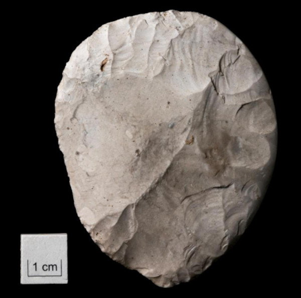
Disc shaped flint knife found at Bulford

Disc shaped flint knife found at Bulford by Phil Harding of Wessex Archaeology

(Wessex Archaeology)

Unearthing the Neolithic Gatherings

The original excavations at Bulford, conducted between 2015 and 2017, revealed 48 pits that were radiocarbon dated to around 2950 BC. Artifacts uncovered included pottery, animal bone, worked flints, and charcoal, suggesting that large numbers of people gathered here over a relatively short period of time to celebrate the solar cycle. One of the pits, which may have been part of a ‘viewing station’, contained an extremely rare disc shaped knife, which was deliberately placed here possibly as a symbolic reference to the sun disc.

Dr Matt Leivers, Senior Research Manager at Wessex Archaeology, noted that:

"what we see at Bulford, and later at Stonehenge, is a way of celebrating and marking the passage of time, but it’s also about making sure the world keeps working as it should. It’s likely their way of saying to their deities, please keep us in mind, keep us warm and safe. It’s a religious event. That’s why it’s so important."

This aligns with other discoveries in the region that point to complex religious and social structures among the Neolithic communities of Britain.

Timeline showing solstice alignment at Bulford and Stonehenge

Timeline showing solstice alignment at Bulford and Stonehenge

(Wessex Archaeology)

Rewriting the History of the Stonehenge Landscape

Dr Fabio Silva, Skyscape Archaeologist at Stone x Sky and the Skyscape Academy, who conducted the analysis that confirmed the alignment, explained that:

"this discovery helps us understand Stonehenge not as a singular creation, but as part of a much longer conversation between people, the land, and the sky. The alignment shows that communities were already engaging with both the summer and winter solstices in the Stonehenge landscape, centuries before the sarsen stones were raised."

The ceremonial site was uncovered during excavations south of the Salisbury Plain Training Area ahead of development to provide accommodation for service personnel. Richard Osgood, Senior Archaeologist at the MoD’s Defence Infrastructure Organisation, said:

“When we started working on the necessary excavations ahead of the construction of new accommodation for soldiers returning from Germany, none of us could have guessed what we would find. Following deeper study, what at first seemed innocuous has completely re-written our understanding of the ceremonial landscape around Stonehenge."

  • Top image: Stonehenge sunset.   
  • Source: simonwakefield/CC BY 2.0  

By Gary Manners

References


Archeologists believe they have discovered ‘prototype’ for Stonehenge

Archaeologists discover 5,000-year-old 'proto-Stonehenge' just a few miles from the famous monument

Scientists discover possible Stonehenge prototype in England

{ https://www.ancient-origins.net/news-history-archaeology }

Hoe vind je dit bericht?
Geschreven door peter om 22:47 Stuur door

Paracas Skulls: Alien Mystery or Human Ingenuity?

Paracas Skulls: Alien Mystery or Human Ingenuity?

A dramatic, atmospheric close-up of a single elongated Paracas child skull resting on a museum display block. AI-generated image created to illustrate the mysterious and striking appearance of the Paracas elongated skulls.

The desolate, wind-swept desert of the Paracas Peninsula on the southern coast of Peru holds one of the most enduring mysteries of the ancient world. In 1928, the renowned Peruvian archaeologist Julio Tello made a staggering discovery beneath the harsh sands. He unearthed a massive and complex graveyard, a sprawling necropolis containing hundreds of elaborate mummy bundles. While the intricate textiles wrapping the dead were marvels of ancient craftsmanship, it was the skeletal remains hidden within that would capture the world's imagination.

Tello had discovered the remains of the Paracas culture, a civilization that flourished from approximately 800 BC to 100 BC. But the skulls of these individuals were profoundly unusual. Over three hundred crania were unearthed, displaying extreme, sweeping elongation that radically altered the natural shape of the human head. For nearly a century, these enigmatic remains have sparked fierce debates, inspiring fantastical theories of extraterrestrial visitation and unknown hominid species.

Anatomy of an Anomaly: Beyond Human Limits?
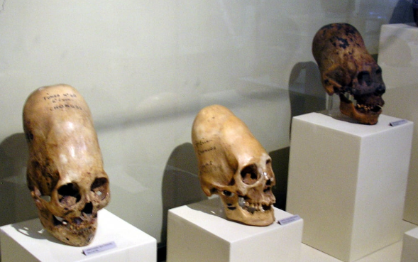
A slightly wider shot showing three actual Paracas elongated skulls lined up in the Museo Regional de Ica.

A slightly wider shot showing three actual Paracas elongated skulls lined up in the Museo Regional de Ica. It provides a great sense of scale and proves this wasn't an isolated anomaly. (Jonski/CC BY-SA 4.0)

The sheer physical presence of the Paracas Skulls is startling. When compared to a standard human cranium, the morphological differences are immediately apparent and deeply perplexing. Proponents of alternative history often point out that some of these skulls possess a cranial capacity up to 25 percent larger than a conventional human head. Furthermore, the bone density and overall weight of certain specimens are reported to be significantly heavier than average.

These startling volumetric anomalies are the primary reason the Paracas Skulls have become central to "ancient alien" hypotheses. Critics of the mainstream archaeological narrative argue that while you can alter the shape of a skull through mechanical pressure, you cannot fundamentally change its total volume or mass. Additionally, some researchers have noted the apparent absence of a sagittal suture, the connective tissue joint that runs down the center of the skull, in some of the most extreme Paracas specimens.

These anatomical quirks have led to bold declarations that the beings buried on the Peruvian coast were not entirely human. The position of the foramen magnum, the opening at the base of the skull where the spinal cord attaches, has also been cited as anomalous. In some Paracas skulls, this opening appears to be positioned further back than in typical humans, suggesting a completely different center of gravity and, consequently, a unique method of bipedal locomotion.

The Science of Artificial Cranial Deformation
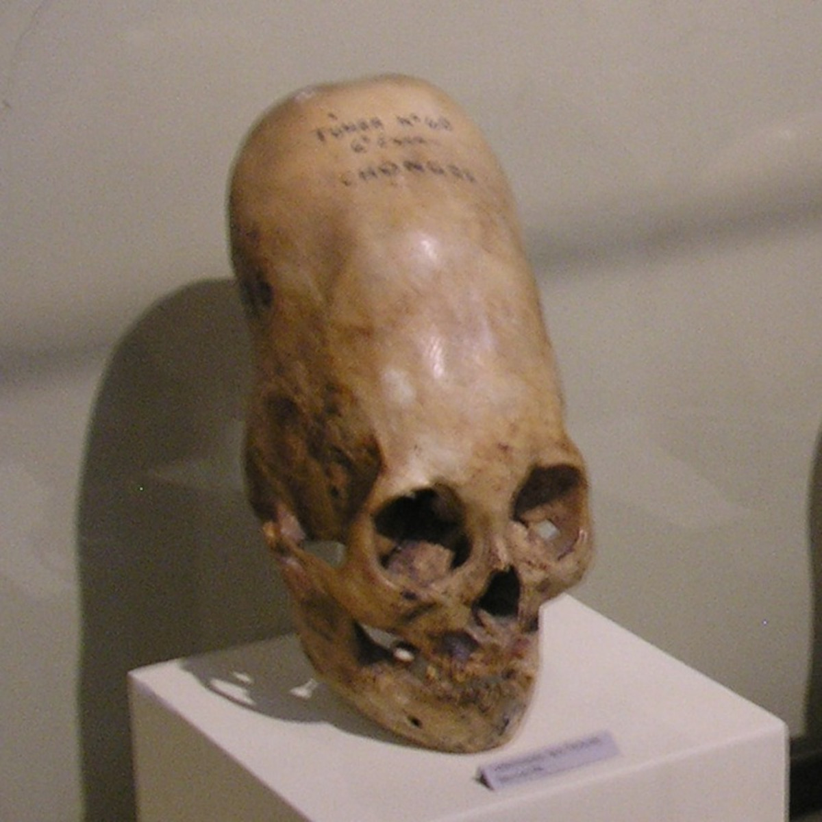
A closer shot of one of the elongated skulls at the Regional Museum of Ica,

Another angle of the elongated skulls at the Regional Museum of Ica, showing the distinct shape of the cranial vault.

(CC BY-SA 4.0/Marcin Tlustochowicz)

Despite the sensational claims of extraterrestrial origins, the broader scientific community provides a thoroughly terrestrial, culturally rooted explanation. The extreme shapes seen in the Ica Museum specimens are widely recognized by bioarchaeologists as the result of artificial cranial deformation. This intentional body modification practice was astonishingly common across various ancient global cultures, from the Huns in Eurasia to the Maya in Mesoamerica.

In the ancient Andes, artificial cranial deformation was a highly formalized practice. According to foundational studies in geometric morphometrics, the process began shortly after birth. An infant's skull is highly pliable, as the cranial plates have not yet fused. The Paracas people would bind a newborn’s head between wooden boards, using tight woolen textiles to direct the growth of the bone upward and backward.

This extreme and arguably painful process was not a random act of cruelty, but a deeply significant cultural tradition. Intentional cranial modification served as a potent, visible marker of identity and social status. In the highly stratified Paracas society, an elongated head was a permanent crown, instantly identifying the individual as a member of the ruling elite or a specific noble lineage. It was a physical manifestation of power and divine connection, literally separating the nobility from the common populace.

Controversial DNA Claims: "Not Human"
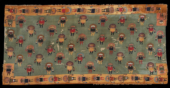
An intricate, ancient Paracas textile

An intricate, ancient Paracas textile. Since the skulls were found inside elaborate mummy bundles wrapped in these exact textiles by Julio Tello, this provides crucial archaeological context.

(Metropolitan Museum of Art/Public Domain)

The debate surrounding the Paracas Skulls reached a fever pitch in 2014 when preliminary DNA testing results were announced to the public. Independent researchers and authors, notably Brien Foerster, commissioned genetic analysis on samples of hair, bone, and teeth taken from several skulls. The initial findings broadcast across alternative media were nothing short of explosive.

The geneticists involved reportedly stated that the mitochondrial DNA, inherited solely through the maternal line, featured mutations that were entirely unknown in any human, primate, or animal species known to science. The narrative quickly shifted from cultural body modification to the sensational idea of a new, unknown hominid. Some reports even suggested the DNA indicated the beings were "not human, Neanderthal, or Denisovan," fueling wild speculation that a separate, perhaps unearthly, race had governed ancient Peru.

These claims generated a whirlwind of media attention and cemented the Paracas Skulls as a cornerstone of modern fringe mythology. For believers, the DNA results were the ultimate vindication, definitive proof that mainstream history was concealing a massive secret about human origins. However, the academic community met these dramatic announcements with intense skepticism, demanding peer-reviewed data, transparent methodologies, and rigorous contamination controls.

Paleogenomics and the Terrestrial Truth
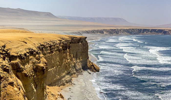
A sweeping aerial photograph of the dramatic golden cliffs and Pacific Ocean coastline at the Paracas National Reserve in Ica, Peru

A sweeping aerial photograph of the dramatic golden cliffs and Pacific Ocean coastline at the Paracas National Reserve in Ica, Peru, the exact coastal desert region where Julio Tello excavated the Paracas Necropolis in 1928 and unearthed the elongated skulls.

(masT3rOD/CC BY 2.0 )

To understand the truth hidden within the ancient bones, one must look to the rigorous field of modern paleogenomics. Extracting ancient DNA (aDNA) is an incredibly delicate process. Remains that have been handled by archaeologists, museum curators, and independent researchers for decades are highly susceptible to modern genetic contamination. Without highly sterilized clean-room environments, the DNA sequenced is often that of the people who recently touched the artifact, leading to confused or "anomalous" data sets.

Recent advancements in population genetics have painted a much clearer, albeit entirely human, picture of pre-Columbian Peruvian populations. Modern, peer-reviewed sequencing has consistently shown that the individuals buried on the Paracas Peninsula were of distinct Native American ancestry. However, as noted in recent articles detailing the DNA analysis, there are fascinating, complex genetic markers that hint at vast, ancient migration patterns, possibly including distant European or Eurasian admixture that challenges our standard timeline of global exploration.

While the DNA does not point to the stars, it does point to a human history that is far more dynamic and interconnected than previously imagined. The Paracas people were master weavers, sophisticated engineers, and survivors in a harsh, unforgiving coastal desert. They developed complex societal structures and religious beliefs that drove them to literally reshape the bodies of their children in pursuit of the divine.

A Legacy Written in Bone
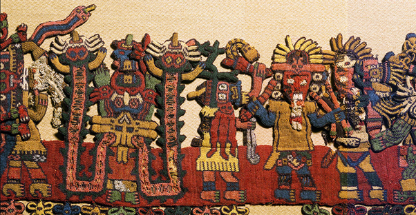
Nasca/Paracas-era mantle (100–300 AD) features ninety intricately needle-knitted figures along its border.

One of the most extraordinary surviving Andean textiles in the world, this Nasca/Paracas-era mantle (100–300 AD) features ninety intricately needle-knitted figures along its border.

(Brooklyn Museum/Public Domain)

Ultimately, stripping away the extraterrestrial mythos does not diminish the profound wonder of the Paracas Skulls; rather, it elevates the ingenuity and resilience of ancient humanity. These elongated craniums are a testament to the lengths to which a culture will go to define itself, to assert its power, and to connect with the spiritual realm. They are a permanent, physical record of an ancient society's deeply held beliefs.

The necropolis discovered by Julio Tello continues to yield secrets, offering vital insights into the health, genetics, and daily lives of a lost civilization. The textiles that wrapped these modified elites remain some of the most complex and beautiful woven artworks ever created in the ancient world. The true magic of Paracas lies not in an alien intervention, but in the astonishing capabilities of the human hands that carved out a civilization on the edge of the Pacific.

As paleogenomics continues to evolve, we will undoubtedly learn even more about the intricate lineage of the Paracas people. For now, their elongated skulls remain safely housed in museums, silent sentinels of a bygone era. They serve as a powerful reminder that human history is wildly diverse, infinitely complex, and deeply fascinating all on its own.

  • Top image: A dramatic, atmospheric close-up of a single elongated Paracas child skull resting on a museum display block. AI-generated image created to illustrate the mysterious and striking appearance of the Paracas elongated skulls.

By Marius Albertsen 

FAQs

  1. Why did the Paracas people elongate their skulls? The Paracas culture practiced artificial cranial deformation as a visible, permanent marker of high social status, elite lineage, and group identity. It visually separated the ruling class from the common people.
  2. How did they achieve the elongated skull shape? The process began during infancy when the cranial bones were still soft and pliable. The baby's head was tightly bound using wooden boards and heavy textiles to force the skull to grow upward and backward over several months.
  3. Did DNA testing prove the Paracas Skulls are alien? No. While early, unverified claims suggested unknown mutations, rigorous scientific ancient DNA (aDNA) testing has confirmed that the skulls belong to human beings of Native American descent, with some tests indicating complex ancient migration patterns.

References

  • Blom, D.E. 2006. Artificial Cranial Deformation in South America: A Geometric Morphometrics Study. Journal of Archaeological Science. Available at: https://www.sciencedirect.com
  • Fehren-Schmitz, L. et al. 2025. Paleogenomics of Ancient Peru: North Coast Population History. Nature Scientific Reports. Available at: https://www.nature.com/srep/
RELATED VIDEOS

Scientists Just Tested DNA From Peru's 'Alien' Skulls — The Results Shocked Everyone

Researchers Examined The Paracas Skulls And Found Something Impossible

I Tested Paracas Skull DNA, and It Changed Everything | Brien Foerster

{ https://www.ancient-origins.net/news-history-archaeology }

Hoe vind je dit bericht?
Geschreven door peter om 18:34 Stuur door

In Antarctica, Scientists Just Discovered a Massive Hidden Structure Deep Below the Frozen Surface

(Image Credit: L. Huffman/Unsplash)

In Antarctica, Scientists Just Discovered a Massive Hidden Structure Deep Below the Frozen Surface

A massive, semi-continent-sized subsurface structure has been discovered by scientists beneath Antarctica’s frozen surface.

The discovery, reported by an international team of scientists, reveals the presence of an unusually shaped feature which researchers with Durham University’s Department of Geography characterize as a “vast geological structure hidden beneath the East Antarctic Ice Sheet.”

The discovery was recently detailed in a study featured in Nature Geoscience.

A Massive Fan-Shaped Structure

Composed of several gigantic basins located beneath more than three kilometers of the southern continent’s icy exterior, the unusual structure has been dubbed the “East Antarctic Fan-shaped Basin Province.”

The massive feature is large enough to be considered continental in scale all by itself and incorporates some of the best-known subglacial features in the region, which include the famous Wilkes and Aurora basins.

The fan-shaped geological megas-structure also features the basin, which comprises Antarctica’s Lake Vostok, which is recognized as the largest subglacial lacustrine feature anywhere on the planet.

“We propose that the fan-like landscape is the product of distributed intraplate rotational extension before the breakup of Gondwana, with three continental-scale consequences,” the team writes in their study.

While the individual basins have all been characterized in past work, the international team reports that the new research marks the first time they have been studied in connection to a singular structure, which they believe was formed through the geological process of distributed rotational extension.

Giant fan-shaped structure found under east Antarctica

Fault-controlled basins and interpreted structural frame in the newly identified EAFBP.

Credit: Nature Geosci

Origins of a Giant Subglacial Structure

At some point in Antarctica’s deep geological history, the continent’s subglacial crust spread out from a central point, resulting in the distinctive fan-shaped appearance it possesses today.

Likening the feature to an open hand, with each of the basins representing gaps between fingers, the research team says it is possible that the newly-characterized East Antarctic Fan-shaped Basin Province “could be one of the largest examples of rotational extension ever seen in continental crust.”

The question of how it formed remains a mystery, although there are several possible explanations.

One involves its formation over the course of several tectonic phases, which researchers believe may be linked to the formation of the ancient supercontinent of Gondwana. According to this theory, the present-day Antarctic land mass’s eventual separation from modern Australia may have played a key role in the breakup that formed the structure in question.

However, remaining questions about the age of the unusual feature also raise possibilities about other geological processes that could have led to its creation.

Today, the structure plays a crucial role in the movement of ice, whereby the distribution of subglacial lakes and basins is primarily governed by its shape. Researchers think this could be important because it would mean the fan-shaped feature may significantly impact the stability of regions of Antarctica that are susceptible to the effects of climate change.

Investigating a Subglacial Mega-Structure

By combining subglacial topographical studies with examinations of geological data, the researchers have tentatively concluded that deep tectonic processes within the continent’s lithosphere, comprising the Earth’s crust and upper mantle, likely played a major role in shaping the structure.

The team combined these data with observations of seismic data, gravity measurements, and magnetic readings as well to help shape the crustal and lithospheric models used as the basis for their study.

According to Durham University researchers, the orientation and elevation of the subglacial topography was calculated based on what the researchers characterize as “rebounded topography,” in which the elevation of land surfaces in East Antarctica were calculated based on how the terrain would respond if none of the ice that currently weights it down were present.

“Laterally, to the west, it caused compression and the consequent uplift of the Gamburtsev Mountains,” the team reports, while to the east, “the northernmost Transantarctic Mountains segment was rotated clockwise by ~20°, overriding the West Antarctic Rift System’s hot lithosphere,” which segmented the mountains into three distinct blocks.

Meanwhile, to the north, the team says the “transcurrent edge of the fan formed the lithospheric weakness that controlled the breakup of Gondwana by driving the propagation of Antarctica–Australia separation and shaping the resulting semi-circular passive continental margins.”

“These processes have influenced the present-day East Antarctica sub-ice landscape and the evolution of the overlying ice sheet,” the researchers say, which includes “the development of glacial troughs and outlet glaciers.”

The team’s recent study, “A fan-shaped subglacial basin province in East Antarctica formed by rotational extension,” was published in Nature Geoscience on June 3, 2026.

  • Micah Hanks is the Editor-in-Chief and Co-Founder of The Debrief. A longtime reporter on science, defense, and technology with a focus on space and astronomy, he can be reached at micah@thedebrief.org. Follow him on X @MicahHanks, and at micahhanks.com.

Distributed rotational extension

Analysis suggests the structure was formed by a process known as distributed rotational extension.

This is where the continental crust has spread out from a central point. The pattern is similar to a hand, with the base of the thumb as the fixed point, and fingers spread out, showing the stretching. The gaps between the fingers are like the triangular basins that form as they open.

Giant fan-shaped structure found under east Antarctica

Proposed two-phase kinematic conceptual model of formation of the EAFBP. Credit: Nature Geoscience (2026). DOI: 10.1038/s41561-026-01991-6

Understanding Antarctica's geological history

The East Antarctic Fan-shaped Basin Province could be one of the largest examples of rotational extension ever seen in continental crust.

It may have developed through multiple tectonic phases linked to the evolution of the Gondwana supercontinent and the later separation between Antarctica and Australia and could even have influenced this break-up.

The discovery also raises fresh questions—particularly around the precise age of the structure and the geodynamic mechanisms that generated it.

However, the significance of the discovery extends beyond historical insight.

The shape of the bedrock hidden beneath the ice sheet continues to influence ice flow today, controlling the distribution of subglacial basins and lakes. This could potentially affect the stability of parts of the Antarctic Ice Sheet that are particularly sensitive to climate change.

Rebounded topography

To investigate the structure, researchers combined subglacial topography with geological observations, gravity, magnetic and seismic data, and crustal and lithospheric models.

They found that the observed structure is a result of a deep tectonic process within the Antarctic lithosphere.

Dr. Guy Paxman from our Department of Geography was part of the research team.

He led on calculating what the elevation of the land surface of East Antarctica would be if all the ice were removed (which would cause the land to rebound upwards by as much as one kilometer).

This "rebounded topography" was used in analysis of the orientation and elevation of the topography of the newly discovered structure.


Ancient Structure Discovered Beneath Antarctica That Shouldn’t Exist | History For Sleep

{ https://thedebrief.org/category/science/ }

Hoe vind je dit bericht?
Geschreven door peter om 21:06 Stuur door

Archaeologists Found a Strange Metal From Beyond Earth Hidden in 3,000‑Year‑Old Treasure Stash

Archaeologists Found a Strange Metal From Beyond Earth Hidden in 3,000‑Year‑Old Treasure Stash

Hidden inside a 3,000‑year‑old hoard, two mysterious objects are made from a rare, otherworldly material that rewrote everything archaeologists thought they knew about Bronze Age Spain.

A Legendary Ancient Treasure Hoard Just Revealed A Strange Metal From The Depths Of Space

© A Legendary Ancient Treasure Hoard Just Revealed A Strange Metal From The Depths Of Space.

Credit: Shutterstock

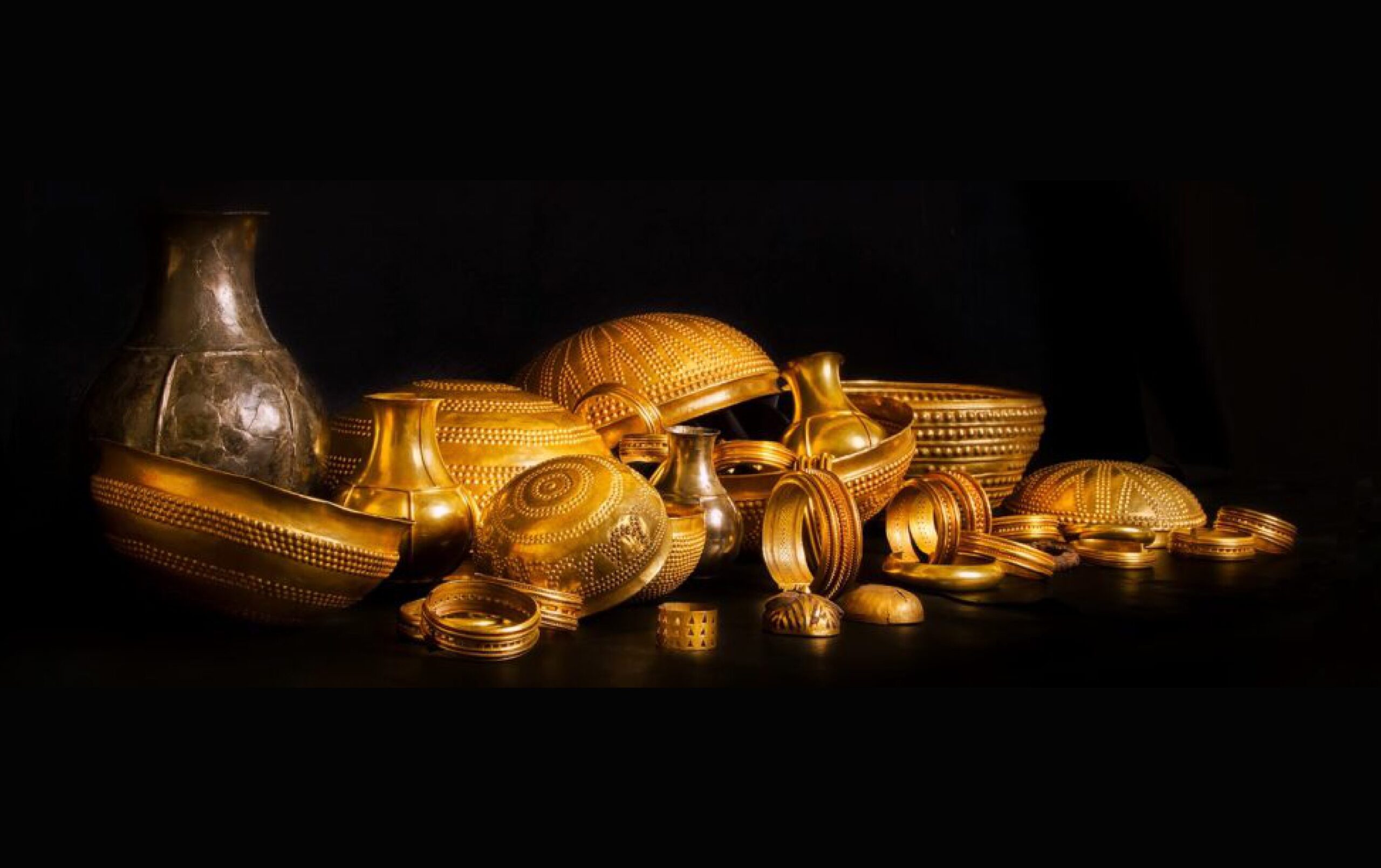
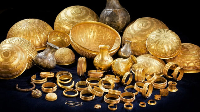
Hidden in a small city museum in southeastern Spain lies a Bronze Age hoard that long puzzled archaeologists. The Treasure of Villena contains 66 objects, mostly gold and silver, with a few stray pieces of iron so unusual that for decades experts could not explain where the metal came from. The airless display cases show bracelets, necklaces, and small ornamental vessels, their surfaces reflecting the soft light of the gallery like they did 3,000 years ago in a forgotten ritual center. The hoard’s composition and craftsmanship have drawn international attention, with recent research spotlighting its unusual meteoritic iron components.

What made the hoard stand out was not just its beauty, but a technical anomaly. The iron items in the Treasure of Villena looked different from the terrestrial iron tools that appeared later in the Iron Age. They were small, highly polished, and unusually resistant to corrosion, which suggested the metal had a special composition. For years, the objects were catalogued as rare but unexplained examples of early ironwork, with no clear source identified. Detailed analyses later revealed that at least two of these pieces were made from meteoritic iron, linking the hoard to material from beyond Earth.

Strange Metal From Beyond Our World Found in an Ancient Treasure Stash

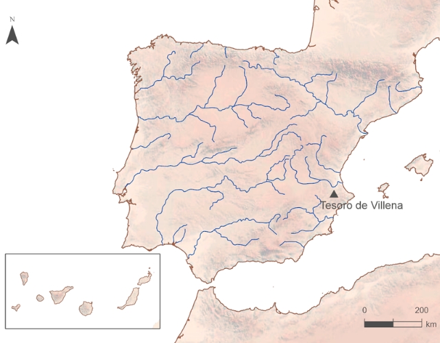
Location of the Villena Treasure (Alicante) in the Iberian Peninsula.

(Credit: Rovira-Llorens et al., Trabajos de Prehistoria, 2024)

The hoard was discovered in 1963 by a civil engineer digging foundations near the town of Villena, in the province of Alicante, Spain. The Archaeological Museum “José María Soler” in Villena now houses the collection, showcasing it as one of the most important prehistoric metal hoards in the western Mediterranean. The objects date to roughly 1400–1200 BC, a period when bronze dominated weapons and tools and iron was still extremely scarce. The museum’s displays present the 66‑piece assemblage in chronological order, helping visitors grasp how valuable metal was in Late Bronze Age society.

A Meteorite in the Bronze Age Collection

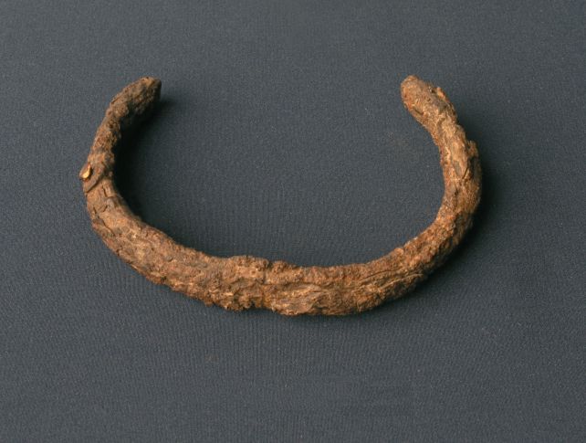
The breakthrough came from a team led by Salvador Rovira‑Llorens, a researcher at the Instituto de Historia of the Consejo Superior de Investigaciones Científicas (CSIC) in Madrid. The team focused on two iron objects from the Treasure of Villena: a small bracelet and a hollow hemisphere often interpreted as a decorative element.

Using mass spectrometry and other analytical techniques, the researchers examined the nickel content and overall chemical signature of the metal in these objects. Their work was later summarized in a public‑facing article that explained how the meteoritic iron fragments were likely treated as rare, high‑status materials.

Iron object

One of the iron objects included in the Treasure of Villena.

Credit: El Museo de Villena

Their analysis revealed that the metal was not ordinary Earth‑sourced iron at all. Instead, it contained a nickel signature characteristic of meteoritic iron, material that originated from a meteorite that fell to Earth. The two objects represent the first known use of meteoritic iron in the Iberian Peninsula, suggesting that Late Bronze Age metallurgists either obtained or repurposed a rare cosmic metal for elite artifacts.

In their paper, published in Trabajos de Prehistoria, the researchers note that the data “suggest that the cap and bracelet from the Treasure of Villena would currently be the first two pieces attributable to meteoritic iron in the Iberian Peninsula, which is compatible with a Late Bronze chronology, prior to the beginning of the widespread production of terrestrial iron.”

A collection of golden objects on a black background.

The Treasure of Villena is almost 10 kilos of gold, including bottles, bracelets and ornaments.

Credit: El Museo de Villena

This finding places the Treasure of Villena alongside other famous meteoritic‑iron objects, such as the dagger in Tutankhamun’s tomb, reinforcing the idea that ancient cultures across Eurasia and North Africa sometimes incorporated space rock into symbolic or luxury items.

The discovery also highlights how far prehistoric metalwork had advanced before the Iron Age, even with limited access to terrestrial iron ores. Public‑facing coverage of the research has helped bring wider attention to the museum and the broader significance of Late Bronze Age metallurgy in Spain.

How Ancient Craftsmen Used Space Rock

The bracelet and the hollow hemisphere are small but technically sophisticated. The bracelet shows evidence of careful hammering and shaping, while the hollow hemisphere has a smooth, almost mirror‑like surface that reflects light in a way typical of well‑worked metal. The corrosion‑resistant nature of the iron pieces likely helped preserve their appearance over millennia, making them stand out even among the more numerous gold and silver objects on display at the Archaeological Museum “José María Soler”.

villena-bracelet.jpg

The iron bracelet, which measures 8.5 centimeters (3.35 inches)

across. Credit: El Museo de Villena

To confirm the meteoritic origin, the team compared the chemical composition of the Villena pieces with known meteoritic samples and with terrestrial iron ores. The high nickel content, along with specific trace elements, matched meteoritic sources rather than typical iron ores available in the region. The pattern is consistent with iron meteorites, which are fragments of the cores of small planetary bodies that never formed into full planets. These space rocks often contain iron‑nickel alloys that can be worked by skilled metalworkers, even in the Bronze Age, and the Treasure of Villena now stands as a key example of such early use.

The discovery adds a new layer to the story of the Treasure of Villena. Rather than being a simple collection of gold and silver elite goods, the hoard now includes at least two objects made from a rare, possibly symbolic material that fell from the sky. The Late Bronze Age communities in the area may have had access to a meteorite fragment or acquired it through trade networks that connected Iberia with other regions of the Mediterranean. The metal’s origin would have been unknown to them, but its unusual appearance and hardness might have made it prized for ceremonial or prestige objects.

A collection of jewellery and other artifacts made of gold

The Treasure of Villena.

Credit: El Museo de Villena

The Treasure of Villena consists of 21 gold objects, 27 silver pieces, 18 amber beads, and these two iron items, all placed together in a buried deposit. The way the objects were arranged suggests a deliberate act of deposition, possibly related to ritual or social change. The Archaeological Museum “José María Soler” in Villena continues to display the hoard, offering visitors a chance to see Bronze Age artistry that, in two small pieces, literally came from beyond our planet.

RELATED VIDEOS


What Archaeologists Found Beneath Ancient Cities Shocked Everyone

Archaeologists Found Treasure with Metal That’s Not from Earth

Extraterrestrial metal found among Spanish Bronze Age artifacts

{ https://dailygalaxy.com/category/science/ }

Hoe vind je dit bericht?
Geschreven door peter om 16:26 Stuur door

Lost Civilizations and Dinosaurs of the Ancient Sahara Desert

Lost Civilizations and Dinosaurs of the Ancient Sahara Desert

ChatGPT-Image-May-31-2026-08_06_45-PM.jpg

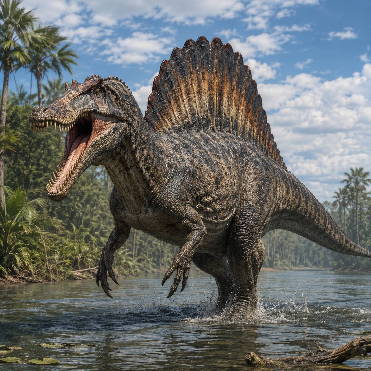
Spinosarus – an ancient dinosaur of the Sahara Desert.

Today the Sahara Desert is known as a vast ocean of sand — a harsh and nearly endless wilderness stretching across North Africa. The Sahara Desert is the largest hot desert in the world, covering an incredible 9.2 million km2, which is almost the same size as China, and has only from two million and one half million to three million people living there. The average annual temperature is 30 degrees Celsius while the hottest temperature ever recorded was 58 degrees Celsius. The area receives little rainfall; half of the Sahara Desert receives less than one inch of rain every year. Towering dunes, burning heat, and empty horizons dominate the modern imagination. Yet thousands of years ago, the Sahara was something entirely different. Beneath its sands lie the buried traces of lost rivers, vanished kingdoms, mysterious stone cities, and forgotten peoples whose stories have nearly disappeared from history. Archaeologists and explorers increasingly believe the ancient Sahara may once have been one of the great cradles of civilization.

Between roughly 10,000 and 5,000 years ago, that territory was not a desert at all. Scientists call this period the “Green Sahara” or the “African Humid Period.” Rainfall transformed the region into a fertile landscape filled with lakes, grasslands, forests, and enormous wildlife populations. Hippos swam in giant lakes. Crocodiles inhabited rivers that no longer exist. Herds of elephants, giraffes, and antelope roamed across plains now buried beneath sand dunes hundreds of feet high. Humans flourished there. Rock paintings discovered in places like Tassili n’Ajjer reveal scenes of cattle herding, dancing ceremonies, hunting expeditions, and mysterious spiritual rituals. Some paintings are over 8,000 years old and provide astonishing evidence of sophisticated societies living in regions now considered uninhabitable.

https://images.openai.com/static-rsc-4/RCtTUo_fCepXISaJFQJyPN9cFYU7KsgPWmBhJH9z2Tppo8NVSWDHszGyHhtIf7tKhNZV4kd5iasUntBhTMH0smXSpYV6Av1GsZK0W81lYF8RL5I-K-IhxR1OeQ8UN656PNYBffnm6Q9CSYMratsp7F_y3LBSeL4VZ0VFmpvo29sE4B3dXL3JNSSUTTLwnyZl?purpose=fullsize The ancient desert as it appeared many thousands of years ago, lush and green on the left and as it appears dry and barren wasteland today on the right.

https://images.openai.com/static-rsc-4/lgCzlxzm4mSvvihfsKYOGQz6A_cVj6rM0Ynhmx6azQBVE_az0Z08060FJqOlXkJ96yk4swEuAYb39VrfHg8OF5YKGyp7FdUEJXLL-s9mkJukgAOLTexAqVie-nzSmlHPtuzvtrCidBokTvd5HaW_Mht_v6lMY7-638A9A3WeRbpNE1_uJMS-YoGg7mlsFYfQ?purpose=fullsize

https://images.openai.com/static-rsc-4/8FkGmEi_WJniYN75-0c1R8GXtpGzmgVyGHhlnsRlB4vQLW32gUpWeqbqUz4xbANpJ_2AYTGGNLxvcaT5F1V0ICIi3cCQp5jhwawCpRM4VJVZyuUw8iJ6hVnxLwX-7XQ9arF9y5zPNWpnbCd36xyMQ_qabVpwh8Oom6W2zHT8l1VhbZ6y_fd0huowl9OSJ9jN?purpose=fullsize

Deep within the remote Ténéré region of the Sahara, archaeologists uncovered graveyards andsettlements belonging to ancient peoples who lived around long-vanished lakes. One of the most famous discoveries came from Gobero in modern-day Niger. There, scientists found human skeletons buried with jewelry, pottery, and ceremonial objects dating back nearly 10,000 years. Some graves showed adults carefully buried holding children, suggesting emotional and spiritual traditions far more advanced than many expected from such ancient cultures.

https://images.openai.com/static-rsc-4/H2WeQJ9W_ZLg4yoqNklDBcLDTYrEZEpWB9ZCHLw41dgtu-xflROWJwsK8XjF8AD7bwp2zEokjQ1bES_IMLVYE2Uk6GhaNSDGMa-HktmHH_aN0TXQNfh5fUz0PidFqmo538K7-FAhcBfAm9_1om3jRNrTX-_KKdK_U2L9IJHlV6Kc_bEuDStRrKzC_muVztys?purpose=fullsize

https://images.openai.com/static-rsc-4/gWvtthgT-cuZCN-cSpBFu285aAthOgA50zCezgVu1LK7AxnYCmNixRE0cQS-_tcNNgKoOkNH1DPPhCHdi5iCxqNqgkcbJqjKnqDILDjLPJZxU4JoAV3ZG8LovcFxWUjX5yQqVoiLZ-xKJv8RdKhglBLkMYVruNxg98UcWSK2xg3RUNwLXA_bPOHftPWTV2p2?purpose=fullsize

Who were these people? What language did they speak? What beliefs guided them? Much remains unknown. As the climate gradually dried, entire populations vanished or migrated toward the Nile River and sub-Saharan regions. Some historians believe these migrations may have helped shape later civilizations, including ancient Egypt.

One of the Sahara’s most astonishing forgotten civilizations was the Garamantes, who thrived in what is now Libya between roughly 500 BCE and 700 CE. Ancient Roman writers described them as mysterious desert people who commanded powerful chariots and controlled hidden oasis cities far beyond the edge of the Roman world. For centuries, many historians dismissed the Garamantes as little more than desert raiders. But modern archaeology revealed something extraordinary. The Garamantes built sophisticated underground irrigation systems called foggaras — miles of tunnels dug beneath the desert to tap hidden fossil water. They constructed cities, maintained trade routes across the Sahara, and connected the Mediterranean world with central Africa.

https://images.openai.com/static-rsc-4/ItF_VHVaZzfLTbsX0a7sTw-Va2oas3kA7k12SOY4_XC4DymOee3xuO2c9rCDF3boEfxXWDB3ZNVdFOQrg7OXYguC7gLSx15HASXBcE6XzklvdRuu3X9Z82l68E0XR6mz-2dP8ENHNrlCZ8xaJJcB2BAQ6imUlfvua2XzWwXkY_bMxx6XNvr7pfjgV3Vg4HNK?purpose=fullsize

Their capital city, Garama, once supported thousands of people in the middle of one of the harshest environments on Earth. Then they faded into obscurity. Today their ruins sit isolated beneath the desert sun, silent reminders that advanced civilizations once flourished where few could survive now.

Satellite technology has revealed strange geometric formations hidden beneath Saharan sands — ancient riverbeds, buried walls, circles of stone, and unexplained ruins. In Mauritania lies the famous Richat Structure, often called the “Eye of the Sahara.” While scientists classify it as a natural geological formation, its enormous circular appearance has inspired theories connecting it to the legendary lost city of Atlantis. Elsewhere, researchers using radar imaging have discovered evidence of ancient waterways crossing regions now completely barren. Some experts believe entire networks of settlements remain buried and untouched beneath dunes that constantly shift with the wind. The Sahara may still conceal cities no modern person has ever seen.

Perhaps the greatest secret of the ancient Sahara is its lost water system. Modern satellite scans show that massive rivers once crossed the desert. One ancient river system may have rivaled the size of the modern Amazon River. These waterways supported fishing villages, farming communities, and trade routes over immense distances. As climate patterns changed, the rains slowly disappeared. Lakes shrank. Grasslands died. Entire populations were forced to abandon their homes.

https://images.openai.com/static-rsc-4/2SPfgiW2NwxSWsdmPbuu867YsGscYyP2GRYVnvbADIOpsplZmnmW_704Ei20dP42c4doFwl7P2KjtPvKCFdCAVcyoyyEWxbKwVkmja9mK8S9h0cMt9JhprNpGU9GEWcq-bySVa27SQNdgh5hk1XFfRReqKlL9OfMxhKHIwKOr7V0bbUyDlhKacvmvPbNTwfd?purpose=fullsize Location of Ancient Lakes of the Sahara Destert https://images.openai.com/static-rsc-4/ttZ7ETomBF3uXQuUSKEooMoVFzaMsmSa9idRUrVVrWLfDowYXRydY2zqbKgVVLpwiBhbWm3z3xWndWczQ6Ly9RhF1GrLlMnMlIkt_LdQRDPvRuYQekCHlr0zaohecYdwlSK_ke0v9s_4NI3ieAbVHHx1gMXkMaKALdA0q_BCR33QLfyPox2o8j7Dno9aaTAF?purpose=fullsize Traces of an ancient civilization may be found here in no man’s land.

What remains today are fragments — pottery buried under dunes, carvings etched into stone cliffs, abandoned tombs, and legends carried through oral tradition. For centuries, caravans crossing the Sahara told stories of forbidden places hidden deep within the sands: ruined temples swallowed by dunes, abandoned cities guarded by spirits, and treasure-filled caverns left behind by forgotten kings. Some explorers searched obsessively for these places. The legendary oasis city of Zerzura — sometimes called “the White City” — appeared in Arabic manuscripts for centuries. Descriptions spoke of a mysterious city hidden somewhere west of the Nile River filled with white stone buildings and guarded entrances carved with strange symbols. No one has conclusively found it. Whether Zerzura was real, exaggerated, or symbolic remains unknown.

The Sahara is so vast that even today large regions remain poorly explored. Sandstorms bury entire landscapes. Ancient sites disappear for centuries before being uncovered again. Every few years, new discoveries reshape what historians thought they knew about ancient Africa. The desert that now appears empty may once have supported thriving civilizations equal in complexity to many better-known ancient cultures. The sands of the Sahara are not merely barren — they are a gigantic archive of forgotten human history waiting to be uncovered. And somewhere beneath those dunes, countless secrets may still sleep undisturbed.

Dinosaurs of the Ancient Sahara Desert

Today the Sahara is famous for its endless dunes, scorching temperatures, and dry winds, but during the age of dinosaurs it was almost unrecognizable. Around 100 million years ago, during the Cretaceous Period, much of the Sahara was covered by enormous river systems, swamps, lakes, and dense vegetation. Giant ferns and conifer trees lined waterways where prehistoric animals gathered to drink and hunt. Paleontologists believe this ancient region was one of the richest dinosaur ecosystems on Earth. Fossils discovered in Egypt, Morocco, Algeria, and Niger reveal a world dominated by gigantic predators and strange creatures unlike anything alive today.

Among the most famous Sahara dinosaurs was Spinosaurus. This enormous predator may have reached lengths of over 50 feet, making it one of the largest meat-eating dinosaurs ever discovered. Unlike most giant carnivorous dinosaurs, Spinosaurus appears to have been semi-aquatic. Scientists found evidence suggesting it could swim through rivers using its powerful tail while hunting giant fish. Its long jaws resembled those of a crocodile and were filled with cone-shaped teeth designed for gripping slippery prey. Rising from its back was a huge sail made of elongated spines, possibly used for display, temperature control, or helping it move in water.

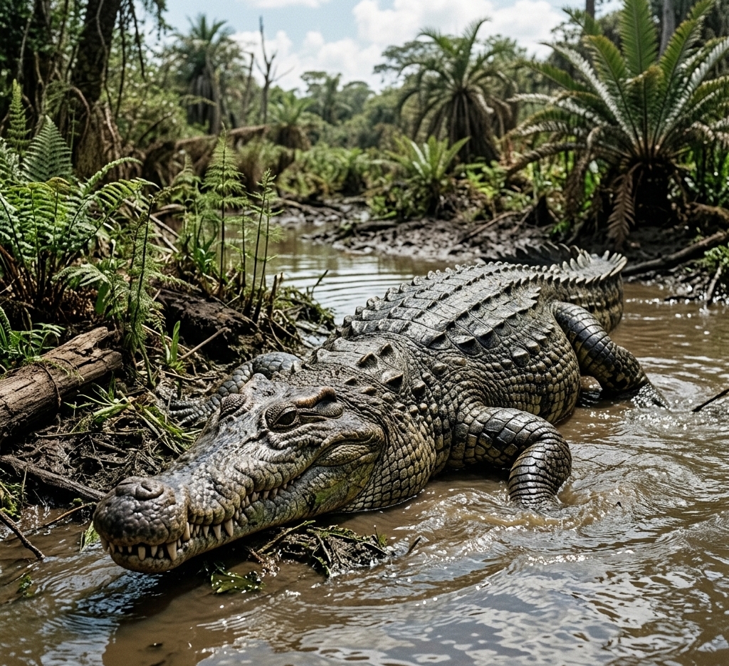
Another terrifying carnivore was Carcharodontosaurus, whose name means “shark-toothed lizard.” This massive hunter possessed serrated teeth nearly eight inches long. It likely preyed on giant plant-eating dinosaurs roaming the floodplains. Some scientists compare it to an African counterpart of Tyrannosaurus rex. The ancient Sahara was also home to bizarre reptiles and enormous flying animals. Giant crocodile relatives such as Sarcosuchus, often nicknamed “SuperCroc,” may have grown over 30 feet long and lurked in rivers waiting for prey. Huge flying reptiles called pterosaurs soared overhead searching for fish along shorelines. Plant-eating dinosaurs also thrived there. Fossils show that long-necked sauropods wandered through forests and marshes feeding on vegetation. These massive herbivores supported entire ecosystems of predators and scavengers.

Over millions of years, Earth’s climate slowly changed. Rivers dried up, forests vanished, and the region transformed into the vast desert seen today. Wind and shifting sand buried countless skeletons beneath layers of rock. Modern fossil hunters continue uncovering remarkable discoveries in the Sahara. In some places, entire prehistoric riverbeds filled with fish bones, dinosaur teeth, and ancient footprints have been found. Each discovery helps scientists reconstruct the lost world that existed long before humans appeared. The Sahara Desert may seem lifeless today, but beneath its sands lies the remains of one of the most extraordinary dinosaur worlds in Earth’s history.

Carchardontosaurus Sarcosuchus
RELATED

The Sahara Desert Was Covering an Entire Ancient Civilization All This Time | DOCUMENTARY

Impossible World Under the Sands of the Sahara | Prehistoric Creatures

Ancient Non-Human Civilization Found Beneath Sahara Sand SHOCKS Historians

{ https://mysticsciences.com/ }

Hoe vind je dit bericht?
Geschreven door peter om 23:01 Stuur door

Mystery deepens over King Tutankhamun's 'alien glass' after stunning discovery

Mystery deepens over King Tutankhamun's 'alien glass' after stunning discovery

Scientists investigating the mysterious 'alien glass' in northern Africa have uncovered new clues about the violent event that created it. 

The strange yellow material, known as Libyan Desert Glass, is scattered across parts of Egypt and Libya and is believed to have formed during an extreme cosmic event around 29 million years ago.

Now, researchers have discovered a rare zircon structure hidden inside the glass that appears to have formed after the mineral completely melted and rapidly crystallized again.

The finding suggests the glass was exposed to temperatures exceeding 4,082°F, hot enough to liquefy one of Earth's most durable minerals.

Researchers believe the crystal preserved a microscopic record of that event, capturing evidence of the extreme heat and rapid cooling that created the glass.

But scientists still cannot agree on exactly what happened. Some believe an asteroid slammed into Earth, while others argue a space rock exploded in the atmosphere with enough force to melt the desert below.

The newly discovered crystal does not settle the debate, but it provides some of the strongest evidence yet that the event involved extraordinary temperatures and formed under highly chaotic conditions.

That finding is shedding new light on the origin of the mysterious glass that ancient Egyptians later prized enough to place in King Tutankhamun's tomb.

Scientists investigating the mysterious 'alien glass' in northern Africa have uncovered new clues about the violent event that created it

Scientists investigating the mysterious 'alien glass' in northern Africa have uncovered new clues about the violent event that created it

That finding is shedding new light on the origin of the mysterious glass that ancient Egyptians later prized enough to place in King Tutankhamun's tomb

That finding is shedding new light on the origin of the mysterious glass that ancient Egyptians later prized enough to place in King Tutankhamun's tomb

Among the many treasures found in King Tut's tomb were elaborate pieces of gold jewelry fashioned with pieces of the yellow glass.

Despite decades of study, researchers have never been able to fully explain how the glass was created. 

However, the leading theories involve a catastrophic cosmic event.

One possibility is that an asteroid or comet struck Earth, generating enormous temperatures and pressures that melted silica-rich rocks into glass. 

Another theory suggests that an incoming space object exploded in the atmosphere before impact, releasing enough energy to superheat the desert below without leaving behind a crater.

The biggest problem for researchers is that no definitive impact crater has ever been linked to the glass field.

Several candidate craters have been proposed over the years, but none have survived scientific scrutiny. That absence has fueled the ongoing debate and turned Libyan Desert Glass into one of planetary science's most enduring mysteries.

In the latest study, researchers from the University of Milano-Bicocca in Milan, Italy examined a tiny zircon inclusion hidden within a sample of the glass. 

The glass has been found in ancient jewellery, including a scarab carved from the material, which features in pectoral jewellery buried beside Tutankhamun

The glass has been found in ancient jewellery, including a scarab carved from the material, which features in pectoral jewellery buried beside Tutankhamun

Zircon is an exceptionally durable mineral often used by geologists to reconstruct ancient events because it can survive conditions that destroy many other minerals.

What they found was unlike anything previously reported in Libyan Desert Glass.

The microscopic zircon measured only about 20 micrometers across, smaller than the width of a human hair, but it displayed an unusual branching, tree-like structure known as a dendritic texture. 

Scientists believe the formation grew extremely rapidly from molten material as the glass cooled.

To investigate, the team used advanced imaging techniques capable of examining structures at the nanoscale. 

These included electron microscopy and three-dimensional diffraction methods that allowed them to study the crystal's internal structure in remarkable detail.

Chemical tests revealed that the trapped glass between the zircon branches was slightly different from the surrounding Libyan Desert Glass. 

It contained higher levels of aluminum and zirconium, indicating it likely came from a separate molten droplet that cooled and solidified independently from the rest of the glass.

The researchers also found something unexpected: there was no evidence of minerals that normally appear when zircon melts and cools. Instead, every crystal they examined remained zircon. 

That finding is shedding new light on the origin of the mysterious glass that ancient Egyptians later prized enough to place in King Tutankhamun's tomb

This suggested the original zircon grain was heated so intensely that it melted completely before rapidly crystallizing again, skipping several intermediate stages that scientists would normally expect to see.

Further analysis showed subtle differences in the atomic structure of the trapped glass compared with the surrounding material. 

The bonds between atoms inside the trapped glass were slightly longer, indicating it experienced a different thermal history during cooling. 

According to the researchers, this supported the idea that the zircon formed from a tiny droplet of molten material that became isolated within the larger mass of molten glass.

The findings suggested the zircon crystal is a microscopic record of an extremely violent event. 

Scientists believe it was created when intense heat melted both zircon and the surrounding silica-rich material, forming a droplet of liquid that cooled so quickly it froze evidence of the process in place.

However, the team noted that the finding carries an important implication.

Based on the chemistry of the zircon and surrounding glass, the team calculated that temperatures likely exceeded roughly 4,082 degrees Fahrenheit. 

For comparison, lava from most volcanic eruptions reaches temperatures of about 1,292°F to 2,192°F, meaning the event that created the glass was significantly hotter than many volcanic processes. 

The researchers described the conditions as being far from equilibrium, meaning the material was heated and cooled so rapidly that normal geological processes could not keep up. 

They noted that the crystal's unusual structure suggested it formed during a chaotic sequence of melting and rapid solidification, preserving evidence of the extreme conditions that created the glass. 

The study also uncovered subtle differences between the glass trapped inside the zircon structure and the surrounding Libyan Desert Glass. 

These differences indicate the material may have existed as a separate molten droplet before becoming trapped and preserved during cooling.

Although the discovery provides some of the strongest evidence yet for extreme heating, it does not settle the long-running debate over the glass's origin.

RELATED VIDEOS


The Most Shocking Discovery Found Inside King Tut's Mask!

King Tut’s Mask Was Scanned Using Quantum Imaging — The Results Shocked Egyptology

King Tut’s Mask Was Scanned With Quantum Imaging — The Result Shocked the Entire Field of Egyptology

The Hidden Queen Behind Tutankhamun’s Tomb | Nefertiti Mystery Documentary

{ https://www.dailymail.com/sciencetech/index.html }

Hoe vind je dit bericht?
Geschreven door peter om 21:10 Stuur door

What Country Has the Most Pyramids? Neither Egypt Nor Mexico

What Country Has the Most Pyramids? Neither Egypt Nor Mexico

eyJidWNrZXQiOiJjb250ZW50Lmhzd3N0YXRpYy5jb20iLCJrZXkiOiJnaWZcL3NodXR0ZXJzdG9jay0xODE0MDg0NDU5LmpwZyIsImVkaXRzIjp7InJlc2l6ZSI6eyJ3aWR0aCI6ODI4fX19
Meroë is home to about 150 pyramids. 
Thomas Markert / Shutterstock

What country has the most pyramids? Surprise! The answer is not Egypt. The country with the most pyramids in the world is Sudan.

While Egyptian pyramids are the most famous—especially those near Giza and Cairo—modern day Sudan actually contains far more ancient pyramids built by a lesser-known civilization along the Nile River.

Here is a breakdown of where most pyramids are found and how they compare across the ancient world.

1. Sudan: The Country With the Most Pyramids

Sudan holds the record for the most pyramids, with between 200 to 255 known structures. These are often called Nubian pyramids or Sudanese pyramids.

They were constructed by the Kingdom of Kush, whose rulers were sometimes known as the black pharaohs. This kingdom ruled areas along the Nile River from about the 8th century B.C.E. to the fourth century C.E.


SUDAN 🇸🇩 The Land of the Pyramids
  • The Kingdom of Kush and Its Pyramid Tradition

The Kushites started building pyramids centuries after ancient Egypt. Their pyramids served as tombs for kings and queens, acting as burial place monuments similar to Egyptian ones.

Kushite kingdoms developed across three main centers: Kerma, Napata and later Meroë, often called the pyramid capital of Sudan. This ancient city and its royal cemeteries contain about 150 pyramids.

Located in the eastern desert, the Meroë contains one of the largest clusters of ancient pyramids in the world and is recognized as a UNESCO World Heritage Site.

  • How Nubian Pyramids Differ From Egyptian Pyramids

Nubian pyramids look very different from Egyptian pyramids. They are much smaller, with many Kushite pyramids standing up to about 98 ft (30 m) tall, compared to the Great Pyramid of Khufu, which originally stood about 480 ft (146.5 m) tall.

They also have steeper sides and narrower tops, often built at angles near 70 degrees, unlike the wider Egyptian designs.

2. Egypt: Home of the Most Famous Pyramids

Egypt ranks No. 2 in total number, with around 138 known pyramids. These include notable examples like the Great Pyramid built for Pharaoh Khufu.
Egyptian pyramids were constructed earlier than those in Sudan and are among the most iconic monuments in the ancient world.


Great Pyramid of Giza: The Greatest Mystery of Ancient Egypt
  • Why Egyptian Pyramids Are More Famous

Despite having fewer pyramids than Sudan, Egypt’s structures are larger and better preserved. The Great Pyramid is considered one of the world’s largest pyramid structures and has drawn attention for centuries.
Its location near major cities like Cairo has also made it more accessible to researchers and tourists.

3. Construction and Cultural Influences

The archaeological sites associated with Sudan’s pyramids reflect Egyptian, Roman and Sahelian African influences, and some temples later show Hellenistic and Roman features. This shows how connected ancient civilizations were through trade and shared ideas.

Artifacts found at these sites suggest that the Kushites had trade networks extending to the Mediterranean and Middle Eastern worlds.

Egyptian pyramids were built earlier, mainly during the Old and Middle Kingdom periods. The Kushite pyramids came later, several centuries after Egypt’s Old and Middle Kingdom pyramid-building periods.

Even so, the Kushites continued building pyramids for nearly 1000 years.

4. What Purpose Did Pyramids Serve?

Both Egyptian and Kushite pyramids were used as tombs for rulers and elites. Inside, archaeologists have found burial chambers, artifacts and evidence of religious beliefs about the afterlife.

5. Other Countries With Pyramids

Other countries—including Mexico, Peru and even China—have pyramid-like structures. However, these differ in design and purpose from African pyramids. Some were temples, ceremonial platforms or tombs.

From the ancient Egyptians to the Kushites, pyramid construction reflects advanced engineering, cultural beliefs and the desire to honor rulers.

These structures remain some of the most enduring monuments on Earth, offering insight into civilizations that shaped human history.

  • We created this article in conjunction with AI technology, then made sure it was fact-checked and edited by a HowStuffWorks editor.

Which Country Has the Most Pyramids? (Not Egypt 😳)
Hoe vind je dit bericht?
Geschreven door peter om 21:48 Stuur door

Meer van UFO'S of UAP'S, ASTRONOMIE, RUIMTEVAART, ARCHEOLOGIE, OUDHEIDKUNDE, SF-SNUFJES EN ANDERE ESOTERISCHE WETENSCHAPPEN - DE ALLERLAATSTE NIEUWTJES

↑ Terug naar de berichten