The purpose of this blog is the creation of an open, international, independent and free forum, where every UFO-researcher can publish the results of his/her research. The languagues, used for this blog, are Dutch, English and French.You can find the articles of a collegue by selecting his category. Each author stays resposable for the continue of his articles. As blogmaster I have the right to refuse an addition or an article, when it attacks other collegues or UFO-groupes.
Druk op onderstaande knop om te reageren in mijn forum
Zoeken in blog
Deze blog is opgedragen aan mijn overleden echtgenote Lucienne.
In 2012 verloor ze haar moedige strijd tegen kanker!
In 2011 startte ik deze blog, omdat ik niet mocht stoppen met mijn UFO-onderzoek.
BEDANKT!!!
Een interessant adres?
UFO'S of UAP'S, ASTRONOMIE, RUIMTEVAART, ARCHEOLOGIE, OUDHEIDKUNDE, SF-SNUFJES EN ANDERE ESOTERISCHE WETENSCHAPPEN - DE ALLERLAATSTE NIEUWTJES
UFO's of UAP'S in België en de rest van de wereld Ontdek de Fascinerende Wereld van UFO's en UAP's: Jouw Bron voor Onthullende Informatie!
Ben jij ook gefascineerd door het onbekende? Wil je meer weten over UFO's en UAP's, niet alleen in België, maar over de hele wereld? Dan ben je op de juiste plek!
België: Het Kloppend Hart van UFO-onderzoek
In België is BUFON (Belgisch UFO-Netwerk) dé autoriteit op het gebied van UFO-onderzoek. Voor betrouwbare en objectieve informatie over deze intrigerende fenomenen, bezoek je zeker onze Facebook-pagina en deze blog. Maar dat is nog niet alles! Ontdek ook het Belgisch UFO-meldpunt en Caelestia, twee organisaties die diepgaand onderzoek verrichten, al zijn ze soms kritisch of sceptisch.
Nederland: Een Schat aan Informatie
Voor onze Nederlandse buren is er de schitterende website www.ufowijzer.nl, beheerd door Paul Harmans. Deze site biedt een schat aan informatie en artikelen die je niet wilt missen!
Internationaal: MUFON - De Wereldwijde Autoriteit
Neem ook een kijkje bij MUFON (Mutual UFO Network Inc.), een gerenommeerde Amerikaanse UFO-vereniging met afdelingen in de VS en wereldwijd. MUFON is toegewijd aan de wetenschappelijke en analytische studie van het UFO-fenomeen, en hun maandelijkse tijdschrift, The MUFON UFO-Journal, is een must-read voor elke UFO-enthousiasteling. Bezoek hun website op www.mufon.com voor meer informatie.
Samenwerking en Toekomstvisie
Sinds 1 februari 2020 is Pieter niet alleen ex-president van BUFON, maar ook de voormalige nationale directeur van MUFON in Vlaanderen en Nederland. Dit creëert een sterke samenwerking met de Franse MUFON Reseau MUFON/EUROP, wat ons in staat stelt om nog meer waardevolle inzichten te delen.
Let op: Nepprofielen en Nieuwe Groeperingen
Pas op voor een nieuwe groepering die zich ook BUFON noemt, maar geen enkele connectie heeft met onze gevestigde organisatie. Hoewel zij de naam geregistreerd hebben, kunnen ze het rijke verleden en de expertise van onze groep niet evenaren. We wensen hen veel succes, maar we blijven de autoriteit in UFO-onderzoek!
Blijf Op De Hoogte!
Wil jij de laatste nieuwtjes over UFO's, ruimtevaart, archeologie, en meer? Volg ons dan en duik samen met ons in de fascinerende wereld van het onbekende! Sluit je aan bij de gemeenschap van nieuwsgierige geesten die net als jij verlangen naar antwoorden en avonturen in de sterren!
Heb je vragen of wil je meer weten? Aarzel dan niet om contact met ons op te nemen! Samen ontrafelen we het mysterie van de lucht en daarbuiten.
17-02-2026
If signals from aliens have already reached Earth, why haven’t they been detected yet?
If signals from aliens have already reached Earth, why haven’t they been detected yet?
For decades, scientists have been searching the skies for signs of extraterrestrial technology. A study by the University of Lausanne poses a pointed question: if signals from aliens have already reached Earth and we haven’t noticed them, what should we really expect to find today?
Why we still haven’t received signals from aliens. Source: phys.org
Searching for intangible technosignatures
Since the first SETI experiment in 1960, astronomers have been scanning the Milky Way for signs of advanced extraterrestrial civilizations. These searches have included radio waves, optical flashes, and infrared thermal signals. So far, nothing has been confirmed. This silence is often explained by the fact that we have only explored a tiny fraction of outer space. But what if signals did reach Earth and passed us by unnoticed?
A technosignature is any measurable signal or physical trace that indicates the existence of advanced technology beyond Earth, such as artificial radio transmissions, laser flashes, or excess heat from large-scale engineering projects.
For the technosignature to be detected, two conditions have to be met. First, the signal has to physically reach Earth. Secondly, our instruments should be sensitive enough, pointed in the right direction, and able to distinguish it from natural signals. This means that a signal may satisfy the first condition but still fail to meet the second. It may be too weak, too short, transmitted on an unsuitable wavelength, or lost in the noise.
It is often assumed that this may already have happened: extraterrestrial technosignatures could have reached Earth over the past six decades but remained undetected. If this is true, it means that even more signals may be passing us by right now, just waiting to be detected as our equipment improves.
SETI researchers investigated how detectable Earth is to alien civilizations, finding that our most visible technosignatures are radio emissions and atmospheric pollutants. If observed from nearby space, lasers, satellites, and city lights would also signal our presence. This study provides a new perspective on Earth’s visibility and helps refine SETI’s search strategies.
How many signals from aliens could have already reached Earth?
A new study challenges this assumption. Claudio Grimaldi, a theoretical physicist at the University of Lausanne’s Laboratory of Statistical Biophysics, has now investigated what unnoticed past contacts could mean for modern SETI searches. Using a statistical approach, Grimaldi asked the question: how many extraterrestrial signals would have had to cross Earth since 1960 for there to be a high probability of detecting one today, and from what distance from Earth would these signals most likely have come?
Grimaldi modeled techno-signatures as emissions from distant technological beings or their artifacts somewhere in the Milky Way. This radiation propagates at the speed of light and, according to this model, can last from very short periods, such as days, to very long periods, spanning thousands of years.
The Earth is considered “contacted” if such a signal passes through our location in space. Detection only occurs when the source is within range, where its signal is strong enough for our telescopes to pick up, reflecting both the signal and the sensitivity of the instruments.
Grimaldi used a Bayesian statistical approach, a method that updates estimates as new information becomes available, to combine three elements: the number of past contacts with Earth, the typical duration of technosignatures, and the range of distances that modern or future instruments can explore.
He considered both omnidirectional signals, such as heat radiation from large structures, and narrowly directed signals, such as beacons or laser flashes. The analysis treats these cases equally.
Research findings that challenge current views
The results of theoretical research cast doubt on the widespread optimistic view. If scientists today want to have a high probability of detecting technosignals at a distance of several hundred or even thousands of light years, this would require a very large number of technosignals to have passed Earth unnoticed in the past.
In many scenarios, this number becomes incredibly large, sometimes exceeding the number of potentially habitable planets in the region of the galaxy, making such scenarios highly improbable, but not strictly impossible.
This only changes when the search covers much greater distances. If technosignals are long-lived and widespread throughout the Milky Way, their detection becomes more plausible at distances of several thousand light-years or more. Even in this case, only a few detected signals can be expected across the entire galaxy at any given moment.
A change in approach to the search for extraterrestrial life
Research indicates that the fact that signals may have escaped detection in the past does not mean that their discovery is imminent. If extraterrestrial technologies exist and have contacted Earth, they are likely to be rare, distant, or long-lasting, rather than close and frequent.
This changes the perception of searching as a patient, long-term endeavor rather than a game of waiting for clear signals. This also strengthens the case for deep and wide surveys covering large parts of the Milky Way, rather than focusing solely on our cosmic neighborhood.
NASA's head of planetary defence has revealed what keeps her up at night – tens of thousands of 'city killer' asteroids that remain undetected.
Dr Kelly Fast, who leads efforts to find and track near–Earth objects like asteroids and comets, admitted they are still looking for around 15,000 mid–sized celestial bodies which could pose a threat.
While an impact from one of these – defined by being at least 140 metres wide – would likely not destroy the planet, they could 'really cause regional damage', she said.
And it turns out Earth still has no way to deflect one if we realised it was heading straight for us.
In 2022, NASA deliberately sent a spacecraft called Dart 6.8 million miles into space to crash into a mini moon called Dimorphos at 14,000mph in a bid to alter its orbit.
This mission was hailed as a success, paving the way for defending our planet by knocking incoming asteroids off their set path towards Earth.
But Dr Nancy Chabot, a planetary scientist at Johns Hopkins University who led that mission, said there are no other Dart–like spacecraft ready to launch if an asteroid was suddenly found to be on a collision course with Earth.
'Dart was a great demonstration,' she said. 'But we don't have [another] sitting around ready to go if there was a threat that we needed to use it for.'
2024 YR4 (pictured) was spotted in December 2024 and set alarm bells ringing as it reached the highest chances of hitting Earth of any known asteroid. Now, experts are concerned that it will hit the moon
An illustration of the main asteroid belt, orbiting the Sun between Mars and Jupiter, where thousands of asteroids can be found
She referenced YR4, an asteroid measuring up to 90 metres wide, which last year was deemed to have a 3.2 per cent chance of hitting Earth in 2032.
Eventually this chance was downgraded to zero, meaning no defensive action needed to be taken.
If something like YR4 had been headed towards the Earth, we would not have any way to go and deflect it actively right now,' she added.
'We could be prepared for this threat. And I don't see that investment being made.'
During the discussion, which took place at the American Association for the Advancement of Science (AAAS) conference in Phoenix, Dr Fast explained the biggest asteroids – which can measure over a kilometre in diameter – are much easier to detect and track.
However, it's believed that only 40 per cent of the mid–sized asteroids have been detected so far – meaning experts don't know where thousands of them are.
When asked what keeps her up at night, she replied: 'It's really the asteroids that we don't know about.
'We're not so much worried about the large ones from the movies, because we know where they are.
In 2022, NASA deliberately sent a spacecraft called Dart 6.8 million miles into space to crash into a mini moon called Dimorphos at 14,000mph in a bid to alter its orbit. Pictured: The asteroid as seen by the DART spacecraft 11 seconds before impact
Most asteroids can be found orbiting our Sun between Mars and Jupiter within the main asteroid belt
'And small stuff is hitting us all the time. Not so much worried about that.
'It's the ones in–between that could do regional damage. Maybe not global consequences, but they could really cause damage.
'And we don't know where they all are. It's not something that even with the best telescope in the world you could find.'
NASA has been tasked by US Congress with finding more than 90 per cent of near–Earth objects larger than 140 metres in diameter.
To achieve this, the agency is currently constructing a space telescope designed with the goal of detecting the majority of near–Earth asteroids and comets within a decade.
It is expected their near–Earth object (NEO) Surveyor mission will launch next year, with the capability of detecting both bright and dark asteroids, which are the most difficult to find.
'We're searching skies to find asteroids before they find us, and get them before they get us,' Dr Fast concluded.
POTENTIAL METHODS FOR ELIMINATING THE THREAT OF AN ASTEROID
DART is one of many concepts of how to negate the threat of an asteroid that have been suggested over the years.
Multiple bumps
Scientists in California have been firing projectiles at meteorites to simulate the best methods of altering the course of an asteroid so that it wouldn't hit Earth.
According to the results so far, an asteroid like Bennu that is rich in carbon could need several small bumps to charge its course.
'These results indicate multiple successive impacts may be required to deflect rather than disrupt asteroids, particularly carbonaceous asteroids,' researchers said.
Nuke
Another idea, known simply as 'nuke', involves blowing up a nuclear explosive close to the asteroid.
However, this could create smaller but still potentially dangerous fragments of rock that could spin off in all directions, potentially towards Earth.
Ion Beam Deflection
With Ion Beam Deflection, plumes from a space probe's thrusters would be directed towards the asteroid to gently push on its surface over a wide area.
A thruster firing in the opposite direction would be needed to keep the spacecraft at a constant distance from the asteroid.
Gravity tractor
And yet another concept, gravity tractor, would deflect the asteroid without physically contacting it, but instead by using only its gravitational field to transmit a required impulse.
Professor Colin Snodgrass, an astronomer at the University of Edinburgh said: 'There have been a few concepts suggested, such as a 'gravity tractor' to slowly tow an asteroid away instead of pushing it with a kinetic impactor.
'But the kinetic impactor is definitely the simplest technology to use on the sort of timescale that is most likely to be of concern for this size of asteroid, i.e. years to decades warning time.'
Antarctica is home to many mysteries, but one of the strangest is an enormous 'gravity hole' deep beneath the ice.
Gravity might feel stable and constant wherever we go, but its strength actually varies over the Earth's surface.
Antarctica has a gravity hole under its surface
Getty
Where the gravity is weaker, the ocean's surface can actually dip well below the average as water rushes towards regions with higher gravity.
Scientists have known for years that gravity is at its weakest in an area of Antarctica's Ross Sea, where sea levels dip 420 feet (130 m) below the surrounding water.
Now, a pair of researchers claim they finally know why.
The vast gravity hole, known as the Antarctic Geoid Low (AGL), is the product of incredibly slow rock movements, according to the experts.
Starting 70 million years ago – a time while dinosaurs still roamed the Earth – less–dense rock built up beneath the frozen continent and weakened the pull of gravity.
The gravity hole started small before rapidly growing in strength between 50 and 30 million years ago – creating the strange ocean dip that we see today.
Scientists have known for years that there is a mysterious 'gravity hole' in Antarctica where the sea level is 420 feet (130 m) below the surrounding water. Now, scientists think they know why
When astronauts on the International Space Station look down on Earth, it might look like a smooth blue marble.
However, in reality, our planet is shaped a bit more like a 'bumpy potato'.
This lumpy surface is due to areas of non–uniform gravity, caused by the uneven distribution of material beneath the surface.
In regions where hot rock from within the Earth's mantle rises towards the surface, the lower density of rock means that gravity is weaker.
Since the 1940s, scientists have known that these gravitational anomalies cause deep depressions across large areas of the ocean.
However, figuring out how and why these gravitational anomalies form hundreds of miles beneath the surface is much harder.
To map how the Antarctic gravity hole formed, the researchers combined earthquake recordings from around the world with a computer model of the planet.
Co–author Dr Alessandro Forte, of the University of Florida, says: 'Imagine doing a CT scan of the whole Earth, but we don't have X–rays like we do in a medical office. We have earthquakes.
Using a computer model, researchers found that the gravity hole was weak around 70 million years ago (left) but started to go stronger between 50 and 30 million years ago (right)
The strengthening of the gravity hole over under the Ross Sea coincided with the rapid advancement of Antarctica's ice sheets, including the Ross Ice Shelf (pictured). Researchers believe these events may be connected
'Earthquake waves provide the "light" that illuminates the interior of the planet.'
By looking at how earthquakes travelled through different densities of rock, Dr Forte and his co–author constructed a map of the planet's inner workings.
Using a computer model, they then worked out where the gravity would be stronger and weaker based on the different types of rock.
Once their predictions matched the best current data from gravity–sensing satellites, they wound back the clock and watched as the gravity hole formed over aeons.
They discovered that the gravity formed slowly at first, before gaining strength in a period known as the Eocene Epoch – beginning 50 million years ago.
Interestingly, this coincided with enormous changes in Antarctica's climate, including the rapid advance of the continent's ice sheets.
Although it is not yet proven, the researchers suspect that there could be a connection between the formation of the gravity hole and the formation of Antarctica's glaciers.
Dr Forte says: 'If we can better understand how Earth's interior shapes gravity and sea levels, we gain insight into factors that may matter for the growth and stability of large ice sheets.'
Scientists have previously found other gravity holes, including the Indian Ocean geoid low (IOGL), which is one of the deepest geoids on Earth
In the future, the researchers want to hunt for a causal connection between the gravity hole and the ice sheets by creating new mathematical models of the climate.
Tectonic plates are composed of Earth's crust and the uppermost portion of the mantle.
Below is the asthenosphere: the warm, viscous conveyor belt of rock on which tectonic plates ride.
The Earth has fifteen tectonic plates (pictured) that together have moulded the shape of the landscape we see around us today
Earthquakes typically occur at the boundaries of tectonic plates, where one plate dips below another, thrusts another upward, or where plate edges scrape alongside each other.
Earthquakes rarely occur in the middle of plates, but they can happen when ancient faults or rifts far below the surface reactivate.
These areas are relatively weak compared to the surrounding plate, and can easily slip and cause an earthquake.
Mars Orbiter Laser Altimeter (MOLA) colorised topographic map of the western hemisphere of Mars, showing the Tharsis region of volcanoes (Credit : NASA / JPL-Caltech / Arizona State University)
When you look at a volcano, you’re seeing the tip of a vastly more complicated system. The mountain itself is just the exit point for processes that have been happening deep underground, perhaps for millions of years. Magma doesn’t simply appear at the surface ready to erupt it rises, stalls, cools, changes, and evolves in underground chambers before finally breaking through.
We’ve known this about Earth’s volcanoes for a long time, but it turns out Mars has been playing the same game. New research published in the journal Geology shows that some of the Red Planet’s youngest volcanic systems had far more intricate histories than anyone realised. An international team of scientists studied a volcanic system south of Pavonis Mons, one of Mars’ giant shield volcanoes in the Tharsis region. Using high resolution images and mineral data from orbiting spacecraft, they essentially performed detective work from space, piecing together clues left behind in the rocks.
Infrared image mosaic showing the shield volcano Pavonis Mons, the central of three peaks in the Tharsis Montes chain, in the central part of the Tharsis region of Mars
(Credit : NASA / JPL-Caltech / Arizona State University)
What they discovered was fascinating. Rather than forming in a single, straightforward eruption, this volcanic system went through multiple distinct phases. Early on, lava poured out through long cracks in the ground, what geologists call fissure eruptions. Later, the style changed completely, with lava erupting from concentrated point sources that built up cone shaped vents.
Here’s the clever bit: although these different lava flows look quite different on the surface, they all came from the same underground plumbing system. Think of it like a house with several taps (and I should know as recently done a load of plumbing in my house, mostly successful!) the water comes from the same pipes, but it emerges in different places and different ways.
The real revelation came from analysing the minerals in each lava flow. Each eruption left behind a distinct mineral fingerprint, and these signatures tell us that the magma itself was evolving over time. The magma was probably coming from different depths, or spending varying amounts of time stored underground before erupting.
Lava rafts and flows, as seen by HiRISE under HiWish program. Location is the Elysium quadrangle on Mars
(Credit : NASA/Jim Secosky)
This matters because we can’t exactly pop over to Mars and chip off a rock sample. Everything we know about the planet’s interior has to come from studying what’s visible on the surface. These volcanic systems are like windows into Mars’ deep interior, revealing processes happening kilometres below ground.
This all suggests that even during Mars’ most recent volcanic period, the planet’s subsurface remained geologically active and complex. The volcano didn’t just erupt once and fall silent, it evolved as conditions beneath the surface shifted and changed. It’s a reminder that Mars, though smaller and colder than Earth, has led a rich geological life. The planet’s volcanic history isn’t a simple story of early activity followed by steady decline. Instead, it’s a tale of ongoing processes, of magma systems that remained dynamic for millions of years, shaping the surface we see today.
A low-altitude demonstration and verification flight test for the Long March-10 carrier rocket and the Mengzhou crewed spaceship system. Credit: Xinhua]
China has achieved several impressive milestones in its space program in recent years. As part of their plan to build an outpost on the Moon that will compete with NASA's Artemis Program - the International Lunar Research Station (ILRS) - they are busy developing a super-heavy launch system and a crew-capable spacecraft that will take taikonauts to the Moon by the end of the decade. That is the plan, at any rate, and recent tests indicate that they are on track to achieve that goal. On Wednesday, Feb. 11th, the China Manned Spaceflight Agency (CMSA) completed a major test of itsLong March-10 rocket and the Mengzhou spacecraft.
The test took place at the Wenchang Spacecraft Launch Site in south China's Hainan Province. It combined a low-altitude demonstration of the Long March-10 and an in-flight abort test of the Mengzhou spacecraft. This was the first ignition flight of the Long March-10 rocket and saw the spacecraft power through the most dangerous phase of ascent - maximum dynamic pressure (or Max Q). This phase occurs as the vehicle accelerates in the lower, denser atmosphere into the thinner upper atmosphere, when aerodynamic stress peaks.
An in-flight abort test, meanwhile, evaluates the crew capsule's safety system, which separates from the rocket in case of emergency. Both the capsule and the rocket's first stage were successful and landed in their designated recovery zones. Key moments in the flight test are featured in the video below, via the state-owned China Global Television Network (CGTN):
Said Ji Qiming, the CMSA spokesperson, during an interview with CGTN:
The test represents the five 'first-times,' as we call it. It's the inaugural ignition flight of the Long March-10 carrier rocket. It's the country's first maximum-dynamic-pressure escape test for a spacecraft. It's the first sea landing and recovery of a crewed spacecraft's return capsule. It's the first sea landing of the rocket's first-stage body. And it's the first ignition launch mission for the newly constructed launch pad for lunar missions.
The Long March-10* is a next-generation partially reusable launch system designed for crewed lunar missions. The rocket comes in two configurations, the first with three stages and two strap-on boosters, similar to SpaceX's Falcon 9 or the ULA's Vulcan and Atlas V rockets. The second, the 10A, has two stages and no boosters. The rocket is powered by seven liquid oxygen (LOX) and kerosene engines in parallel. The Mengzhou* spacecraft (Chinese for 'Dream Vessel') is a reusable vehicle capable of carrying 6 to 7 taikonauts.
After the spaceship separated, the rocket continued ascending until the first stage reached its predetermined height and speed, when its engines were shut down. The rocket then commenced its glide phase and changed its orientation several times, shifting from nose-forward to tail-forward. At an altitude of about 110 km (68 mi), the rocket deployed its four grid fins to prepare for landing. Two of its engines were then reignited for the powered deceleration phase, which was followed by the aerodynamic deceleration phase that relied solely on its grid fins to slow down and adjust its position.
During the final landing phase, three engines were reignited, and the rocket maneuvered toward its landing site. When it was just a few meters above sea level, the rocket hovered in place while ground crews tested an onboard tether mechanism to simulate a recovery using a ground-based net system. The rocket then splashed down in the ocean, where recovery crews retrieved it.
The first stage of the Long March-10 carrier rocket safely splashes down in the predetermined sea area in a controlled manner as planned, Feb. 11, 2026.
[Photo/Xinhua]
Said Zhu Pingping of the China Aerospace Science and Technology Corporation:
After completing this test flight, we can say that both the ascent profile of the Long March-10 series' first stage and the return profile of the Long March 10A have been validated. This means that the risks associated with subsequent formal mission flight tests can be effectively eliminated and controlled.
This test places China a step closer to its goal of landing astronauts on the Moon by 2030 and sending crews to other locations in deep space - like Mars. Combined with their planned expansion of the Tiangong space station, robotic missions to explore a Near Earth Asteroid (NEA), a Main Belt comet, and a Mars Sample Return (Tianwen-2 and -3, respectively), China is assuming a leadership role in space.
While most of the world's glaciers are retreating as the climate warms, a small but significant population behaves very differently—and the consequences can be severe. A team of international scientists, led by the University of Portsmouth, has carried out a comprehensive global analysis of surging glaciers, examining the hazards they cause and how climate change is fundamentally altering when and where these dramatic events occur.
Glacier surges—when a glacier suddenly moves much faster than normal—rapidly transport ice to the glacier front and often cause advances. These events typically last for several years, with many glaciers experiencing repeated surges separated by decades of relative inactivity.
The study, published in Nature Reviews Earth & Environment, compiled a database of more than 3,100 glaciers that have surged. Rather than being scattered globally, these glaciers cluster in dense groupings across the Arctic, High Mountain Asia and the Andes.
It includes the key features and basic processes controlling glacier surges, characterizes the wide range of surging behaviors, and maps the global locations of surge-type glaciers and the climate conditions that cause them to cluster in specific areas.
"Surge-type glaciers are very unusual and can be troublesome," said lead author Dr. Harold Lovell, Senior Lecturer and glaciologist from the University of Portsmouth's School of the Environment and Life Sciences. "As a friend and fellow glaciologist once put it, they save up ice like a savings account and then spend it all very quickly like a Black Friday event. But while they only represent 1% of all glaciers worldwide, they affect just under one-fifth of global glacier area, and their behavior can result in serious and sometimes catastrophic natural disasters that affect thousands of people."
Contrary to what you might expect, the researchers found surging makes glaciers more vulnerable to climate change. When they surge, these glaciers are responsible for a large proportion of ice mass loss in some regions.
Six major hazards identified
The research identified six main types of hazards caused by glacier surges that affect communities in high mountain regions, which can result in damage to infrastructure and in some cases loss of life:
Glacier advance—ice overruns buildings, roads and farmland
River blockages—surging glaciers dam rivers, creating dangerous lakes that can release devastating floods
Meltwater outbursts from beneath the glacier—these also release potentially devastating floods
Sudden detachments of glaciers—cause large ice and rock avalanches
Widespread crevassing—high ice velocities fracture glacier surfaces, making travel extremely hazardous in regions where glaciers serve as highways between settlements and are used for tourism activities, and affecting climbing routes where glaciers provide access to mountain peaks
Iceberg hazards—when glaciers surge into the sea, they release numerous icebergs in a short time, creating risks for shipping and marine tourism
Using this data, the research team identified 81 glaciers that pose the greatest danger when they surge. The majority are in the Karakoram Mountains in High Mountain Asia, where populated valleys and critical infrastructure lie directly below surging glaciers. These glaciers are large, close to communities, and most have histories of repeated surging behavior.
Climate change is making surges increasingly unpredictable
Perhaps most concerning is the growing evidence that climate warming is fundamentally changing how glacier surges behave—making them harder to predict just when better forecasting is most needed for hazard management.
"By drawing on previous studies, we have been able to piece together the growing body of evidence that shows how climate change is affecting glacier surges, including where and how often they happen," Dr. Lovell said. "This includes instances of extreme weather such as heavy rainfall events or very warm summers triggering earlier than expected surges, suggesting an increasing unpredictability in their behavior."
The picture emerging from the research is complex and regionally varied. Some glaciers are now surging more frequently than they did several decades ago, while in other regions surge activity is declining. There is evidence that some glaciers have thinned so much they can no longer build sufficient ice to surge in the future.
Surge behavior may also shift to new regions entirely. It is known that surging glaciers are currently concentrated in the Arctic and sub-Arctic (48%) and High Mountain Asia (50%), where specific climate conditions make surges more likely. But ongoing climate warming may change this distribution dramatically.
Surges might largely stop in places like Iceland, where glaciers are shrinking rapidly and struggling to accumulate enough ice. Meanwhile, they could become more frequent in parts of High Mountain Asia and in the Canadian and Russian Arctic due to warmer temperatures and increased meltwater. It's even possible that glaciers might begin surging in the Antarctic Peninsula and other areas where surge-type glaciers are not currently known to exist.
Co-author Professor Gwenn Flowers, from Simon Fraser University in Canada, said, "The challenge we face is that just as we're starting to develop a more comprehensive understanding of the mechanisms behind glacier surges, climate change is rewriting the rules. Extreme weather events that might have been rare even 50 years ago could become triggers for unexpected surges. Given that surges cause hazards in some settings, this makes protecting vulnerable communities much more difficult."
Dr. Lovell added, "This research is extremely important because understanding which regions have concentrations of surging glaciers helps us plan monitoring efforts and understand future behavior. Knowing which specific glaciers pose the greatest risks can help protect communities, especially those most at risk. But the increasing unpredictability means we need much better surveillance and forecasting capabilities."
The findings emphasize the urgent need for continued satellite monitoring, expanded on-the-ground observations of conditions during surges, improved computer models of surge processes, and projections of how surging glaciers will respond to ongoing climate warming.
Publication details
Harold Lovell et al, Glacier surging and surge-related hazards in a changing climate, Nature Reviews Earth & Environment (2026). DOI: 10.1038/s43017-025-00757-9
De aardkern heeft mogelijk negen keer zoveel waterstof als alle oceanen op aarde bij elkaar.
Deze waterstof is waarschijnlijk ontstaan tijdens de vorming van de aarde en niet door latere inslagen van kometen.
Onderzoekers hebben een nieuwe techniek gebruikt, atoomprobetomografie genaamd, om individuele atomen in ijzermonsters die de omstandigheden in de kern van de aarde nabootsen, rechtstreeks te observeren, wat tot deze baanbrekende schatting heeft geleid.
De aardkern bevat mogelijk enorme reservoirs aan waterstof, mogelijk negen keer zoveel als alle oceanen op aarde samen. Volgens recent onderzoek in Nature Communications zou de aardkern wel waterstof kunnen bevatten ter hoeveelheid van 45 oceanen.
Vroege waterverwerving
Wetenschappers denken dat deze waterstof tijdens de eerste vorming van de aarde in de aarde is opgenomen, en niet door latere kometeninslagen die water op het oppervlak zouden hebben afgezet. Dit betekent dat de aarde het grootste deel van haar water vroeg in haar geschiedenis heeft gekregen, waarbij de mantel en de korst minder water bevatten dan de kern.
De aardkern, die voornamelijk bestaat uit ijzer en nikkel, genereert het beschermende magnetische veld van de planeet. Inzicht in het waterstofgehalte in deze kern is cruciaal voor het begrijpen van de vorming van planeten en de evolutie van het leven. Het is echter onmogelijk om de kern rechtstreeks te observeren vanwege de enorme diepte en de extreme druk.
De kern van de aarde bestaat voornamelijk uit de metalen ijzer en nikkel, maar bevat ook lichtere elementen zoals waterstof, zuurstof en silicium.
CharlesC via Wikimedia Commons onder CC-BY-3.0
Nieuwe observatietechniek
Eerdere pogingen om de waterstof in de kern te meten gebruikten indirecte methoden. Ze analyseerden bijvoorbeeld de structuur van ijzerkristallen. Dit leidde tot sterk verschillende schattingen. In het nieuwe onderzoek gebruiken de wetenschappers een techniek genaamd Atoomprobe-tomografie. Daarmee kunnen ze individuele atomen in een monster direct bekijken. Dit gebeurt onder hoge druk en temperatuur, zoals in het binnenste van de aarde.
De onderzoekers smolten ijzermonsters in een diamant-aambeeldcel. Daarna gebruikten ze Atoomprobe-tomografie om te zien hoe waterstof, silicium en zuurstof waren verdeeld. Zo konden ze de verhouding tussen waterstof en silicium ongeveer op 1:1 schatten. Door dit te combineren met eerdere schattingen van het siliciumgehalte in de kern, konden ze ook de totale hoeveelheid waterstof benaderen.
Onzekerheden blijven bestaan
De nieuwe methode geeft waardevolle inzichten in de samenstelling van de kern. Ook helpt het te begrijpen hoe warmte wordt afgegeven, wat bijdraagt aan het magnetisch veld van de aarde. Onderzoekers geven wel aan dat er nog onzekerheden zijn. Zo kan er tijdens het decompressieproces waterstof verloren gaan, waardoor de hoeveelheid waterstof misschien wordt onderschat.
Meer onderzoek is nodig om deze schattingen te verbeteren. Ook willen wetenschappers de complexe chemische interacties in de kern beter begrijpen. Toch laat het onderzoek zien dat waterstof belangrijk is voor de ontwikkeling van de aarde. Het speelde al een grote rol in een vroeg stadium van de vorming van planeten.
Surprise, surprise: all that climate stuff scientists have been warning us about is coming back to bite us. And by us, of course, we mean all of humanity.
As reported by the Guardian, scientists just published a warning that Earth is approaching a point of no return. A new study in the journal One Earth shows multiple climate systems — the Greenland ice sheet, the West Antarctic ice sheet, boreal permafrost, the Amazon rainforest — are all much closer to collapse than previously thought.
Will the Earth become uninhabitable? New experiment predicts interesting future
“Research shows that several Earth system components may be closer to destabilising than once believed,” the researchers urged. “While the exact risk is uncertain, it is clear that current climate commitments are insufficient.”
The analysis is based on climate “tipping points,” meaning collapses of environmental systems that lead other climate systems beyond their own tipping points, creating a snowball scenario where the planet spirals into a worst-case-scenario known as “hothouse Earth.” Under this scenario, the long-term temperature is projected to rise about 9 degrees Fahrenheit above pre-industrial averages — which would be really bad.
“Crossing even some of the [tipping point] thresholds could commit the planet to a hothouse trajectory,” said Christopher Wolf, a scientist at the environmental group Terrestrial Ecosystems Research Associates. “Policymakers and the public remain largely unaware of the risks posed by what would effectively be a point-of-no-return transition.”
What makes this all particularly insulting is the fact that the poor people of the world — those who will suffer the earliest and deepest losses as a result of climate change — are powerless to stop these tipping points from boiling over. And not for lack of will: the global climate movement is growing steadily, as Americans have perhaps never been more aware that climate change will impact the low-income people of the world the most.
Will the Earth become uninhabitable? New experiment predicts interesting future
Unfortunately, the power to reverse these decisions doesn’t belong to the people, but to a small cabal of the ultra-rich. The future of the planet is so far out of our control that some environmental experts argue not even the world’s most powerful governments can stop the collapse.
As University of Manitoba professor David Camfield and author of the 2022 book “Future on Fire: Capitalism and the Politics of Climate Change” has explained, the level of political power held by the ultra-rich and their corporations is so immense that even a government with popular support and commitment to emissions cuts would struggle under the weight of corporate investment strikes, pressure from credit agencies, and catastrophic market disruption.
“To weaken those political obstacles sufficiently that a government could get a just transition underway would take massive pressure of the kind that only movements can unleash,” Camfield asserts.
The math, in other words, is brutal. Capitalism’s logic demands unending accumulation of wealth, leading to a world in which corporations must grow or die, no matter the consequences. To transition out of this mess would mean weakening capital’s entire grip on power — something which has only ever been achieved when the great masses of toiling people come together to demand a better world.
Last year, NASA’s Curiosity rover made a fascinating discovery after boring into a suspected ancient lake bed on Mars: long-chain organic molecules, called alkanes, that could serve as a potential chemical relic of ancient life on the Red Planet.
The molecules, researchers suggested at the time, could have derived from fatty acids, which are common building blocks of cell membranes on Earth, once again strengthening the case that Mars could’ve been teeming with life billions of years ago.
It was just another tantalizing clue in our search for extraterrestrial life, not the smoking gun we’ve all been waiting for.
Nonetheless, scientists continue to be fascinated by the finding. In a paper published in the journal Astrobiology last week, a team led by NASA Goddard Space Flight Center’s Alexander Pavlov argues that the presence of these molecules — despite the millions of years of destructive radiation that pummeled the Martian surface after it lost much of its atmosphere — “cannot be readily explained” by non-biological processes alone.
One theory is that carbon-rich dust particles and meteorites could have deposited these long-chain organic molecules on the surface, with the ancient Martian atmosphere allowing the organics to accumulate billions of years ago.
However, Pavlov and his colleagues aren’t convinced. After studying how 80 million years’ worth of pelting radiation could have affected these molecules, they concluded that prior to the loss of the planet’s atmosphere, the concentration of these alkanes was likely much higher than previously thought. To help explain their findings, they took into account other non-biological processes in an attempt to arrive at their inferred original abundance — but couldn’t, even after combining all of them.
In other words, biological processes like the ones observed on Earth are still a leading theory, even after researchers’ best efforts to find a non-life explanation.
“We argue that such high concentrations of long-chain alkanes are inconsistent with a few known abiotic sources of organic molecules on ancient Mars,” they wrote.
Nonetheless, they stopped well short of making any definitive statements about life on the Red Planet. After all, there could be still-unknown, non-biological processes we don’t know about that could have resulted in the observed concentration of long-chain carbon molecules on Mars.
“We agree with Carl Sagan’s claim that extraordinary claims require extraordinary evidence and understand that any purported detection of life on Mars will necessarily be met with intense scrutiny,” they concluded in their paper. “In addition, in practice with established norms in the field of astrobiology, we note that the certainty of a life detection beyond Earth will require multiple lines of evidence.”
Nonetheless, it’s a tantalizing waypoint in our longstanding efforts to determine whether Mars, a planet that was once covered in huge oceans, rivers, and lakes, could have supported life.
Pavlov and his colleagues are now calling for further research into how radiation degraded these intriguing molecules under Mars-like conditions to shed more light on the matter.
In 1966, the Soviet Union made history when its Luna 9 mission placed the first object built by humans on the surface of the Moon, broadcasting imagery back to Earth following its successful soft landing.
Despite the safe touchdown of Luna 9’s lander capsule, some questions have lingered about the Soviet spacecraft’s historic mission: namely, its final resting place, which remains unknown.
That could be about to change, however. With the help of artificial intelligence, an international team of researchers has identified several locations on the Moon they believe could finally reveal the location of the “lost” spacecraft.
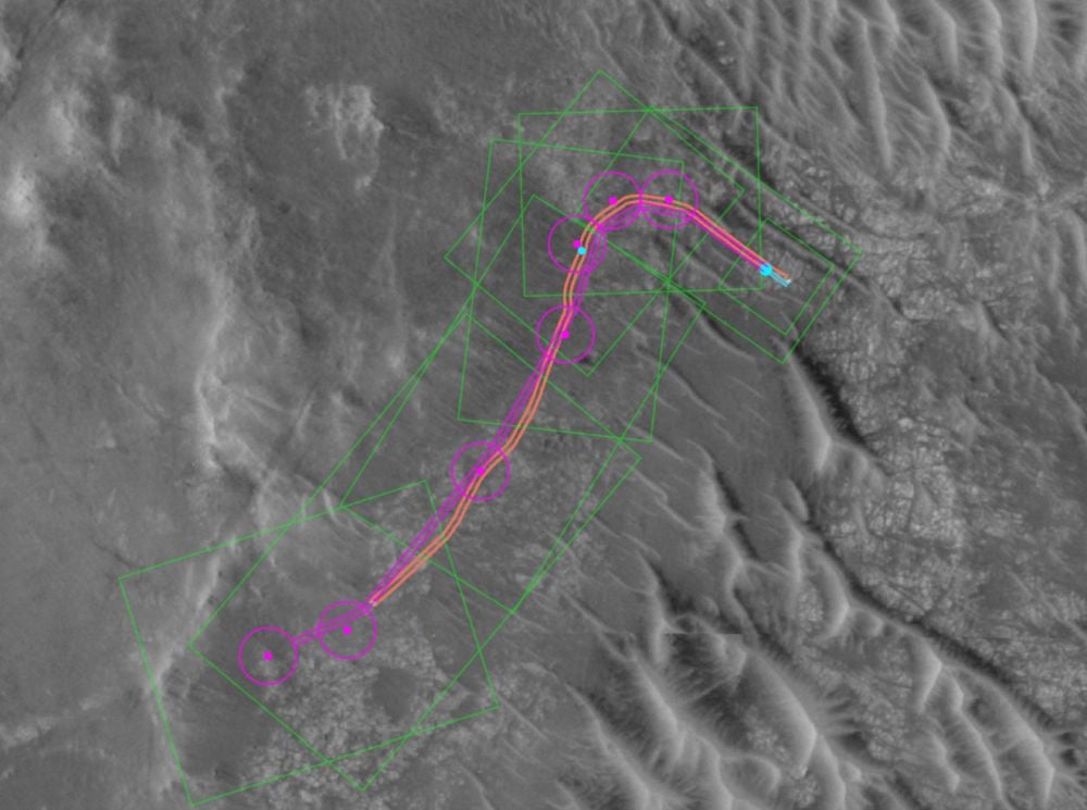
Among these possible landing sites, one location near lunar N latitude 7.02907° and longitude -64.32867° is particularly promising, revealing a large crater with a bright area near one of its edges, which is surrounded by several other impact features, which researchers say may represent “potential spacecraft hardware objects” left behind by the 1966 mission. The team’s findings were published in npj Space Exploration.
A Cold War-Era Mystery
Luna 9’s historic 1966 lunar landing marked the first instance where a piece of human-built hardware had been placed on the surface of a celestial body beyond Earth.
By modern standards, the Luna 9 landing was hectic, with the spacecraft tumbling along the lunar surface on built-in shock absorbers before finally settling in its final resting place, where it remained operational for only a matter of days. During that roughly 36-hour window, the spacecraft successfully transmitted important information back to Earth, setting the pace for space exploration in the coming years that would eventually bring the first humans to the Moon.
Above: A replica of the Luna 9 spacecraft, as seen in the Museum of Air and Space in Paris, France
(Image Credit: Wikimedia/Pline/CC 3.0)
Despite high-resolution imagery of the lunar surface that has been readily available since the deployment of NASA’s Lunar Reconnaissance Orbiter Camera (LROC) in 2009, no confirmed detection of the Luna 9 landing site has been made. One reason for this involves the original calculations made about the spacecraft’s 1966 landing, which were far from exact. By some estimates, the location of Luna 9 could be as much as several dozen kilometers away from the general area where the spacecraft is believed to have landed.
Rediscovering a Lost Soviet Spacecraft
In recent research led by Lewis Pinault at University College London, along with colleagues Hajime Yano and Ian Crawford, artificial intelligence was used to narrow down possible locations of the “missing” Luna 9 lander.
Enter the intriguingly-named “You-Only-Look-Once – Extraterrestrial Artefact” (YOLO-ETA), which the researchers describe as a lightweight computer imaging system adapted from TinyYOLOv2, an architecture designed to detect human-built objects, such as spacecraft, in high-resolution LROC images.
Training YOLO-ETA using the well-known landing sites of NASA’s Apollo missions, the team says they reached an overall confidence score for possible spacecraft detections of around 80%, which enabled them to then train the imaging system on the general region where Luna was believed to have touched down.
Above: possible locations where artificial objects, detected using YOLO-ETA, may indicate the landing site of the Soviet Luna 9 spacecraft
(Image Credit: NASA/GSFC/Arizona State University/npj Space Exploration, Pinault, et al)
“Applying the model to a 5 × 5 km region surrounding the historically uncertain Luna 9 landing area yielded several high-confidence detections of artificial objects near 7.03° N, –64.33° E,” the researchers report. “Topographic analysis indicates that the candidate site’s horizon geometry is potentially consistent with Luna 9 surface panoramas.”
Notably, the team was able to determine a primary impact feature, in which a luminous area can be discerned, which they believe may be the final landing place of Luna 9. In the surrounding area, several additional impacts or other features can also be seen, which may be secondary “hardware objects”—essentially debris left over from the 1966 mission.
The locations Pinault and his colleagues identified appear to be consistent with the kinds of features associated with known spacecraft landings and the disturbances they have caused to the Moon’s surface during past lunar missions.
“These findings identify promising locations for follow-up imaging and demonstrate that compact, edge-deployable machine-learning models can support future orbital surveys of lunar artefacts and surface assets,” the team writes in their paper.
Going forward, Pinault and colleagues believe they YOLO-ETA may be useful “in detecting known lunar artefacts and can assist in the search for undetected historical spacecraft.” Such capabilities, they argue, are of great importance as they will help to support various space agencies’ ability to monitor the lunar surface in the coming years, especially as exploration of Earth’s natural satellite is expected to increase.
For now, the team’s findings remain to be confirmed, though they believe such an opportunity will likely occur as soon as next month, when India’s Chandrayaan-2 orbiter passes over the region. If YOLO-ETA’s assessment turns out to be correct, it will finally bring a resolution to one of the great unanswered questions of Cold War-era space exploration.
Pinault, Crawford, and Yano’s recent study, “Possible identification of the Luna 9 Moon landing site using a novel machine learning algorithm,” appeared in npj Space Exploration.
Micah Hanks is the Editor-in-Chief and Co-Founder of The Debrief. A longtime reporter on science, defense, and technology with a focus on space and astronomy, he can be reached atmicah@thedebrief.org. Follow him on X @MicahHanks, and at micahhanks.com.
Scientists have captured the astonishing moment a supergiant star collapsed into a black hole.
The now–deceased star, dubbed M31–2014–DS1, was located around 2.5 million light–years from Earth in the neighbouring Andromeda Galaxy.
In 2014, NASA telescopes recorded the distant star brightening briefly before fading out of existence over the next three years.
Now, scientists have realised they had inadvertently watched as the star died, collapsed, and transformed into a black hole.
What makes this observation so exciting for astronomers is that this isn't how black holes were thought form.
Until now, experts have widely believed that black holes form when supermassive stars collapse and die with supernova explosions.
However, M31–2014–DS1's gradual decline into oblivion suggests that stars can actually create a black hole without the enormous explosion.
Lead author Dr Kishalay De, a researcher from the Flatiron Institute, says: 'It comes as a shock to know that a massive star basically disappeared – and died – without an explosion and nobody noticed it for more than five years.'
Scientists have captured the astonishing moment a supergiant star collapsed into a black hole
Instead of exploding into a supernova like other stars of its size, this star failed to explode and was crushed into a small stellar black hole
When a star is born, it is held in a state of balance as the outward pressure from burning hydrogen matches the inward push of gravity.
But as the star begins to run out of fuel after billions of years, that outward pressure falters, and the star begins to collapse under its own gravity.
At the same time, a wave of energy released from the collapsing core blasts remaining outer layers into space in a supernova explosion – leaving the neutron star behind.
Only stars about 20 times the size of the sun are big enough to form black holes in this way, but scientists have long suspected that there could be a way for smaller stars to form black holes as well.
If something were to stop the star from producing a supernova to blast the outer layers away, all that extra material might fall into the neutron star and turn it into a black hole.
This is exactly what Dr De and his colleagues think they have just seen at M31–2014–DS1.
When this star was born, it was around 13 times the mass of the sun, dwindling to around five solar masses by the end of its life.
The researchers looked through data collected by various telescopes (pictured) and found that the star briefly got brighter in 2014 and then rapidly dimmed below its initial luminosity in 2016
According to our understanding of stellar life cycles, a star of this size should have exploded with a supernova and produced a neutron star – but this doesn't appear to be what happened.
In their study, the researchers looked at light from M31–2014–DS1 collected by various telescopes between 2005 and 2023.
The star briefly glowed with infrared light in 2014, then suddenly dropped below its original brightness in 2016.
When telescopes looked again in 2022 and 2023, the star was barely visible in most parts of the electromagnetic spectrum.
The star had essentially vanished in visible and near–infrared light, becoming one ten–thousandth as bright in these wavelengths, and could only be seen in mid–infrared, where it is one tenth as bright.
'This star used to be one of the most luminous stars in the Andromeda Galaxy, and now it was nowhere to be seen,' says Dr De.
'Imagine if the star Betelgeuse suddenly disappeared. Everybody would lose their minds!'
Instead, the researchers argue that the data collected from the star's prolonged fading perfectly matches what we would expect to see from a 'direct collapse' black hole.
The now–deceased star, dubbed M31–2014–DS1, was located around 2.5 million light–years from Earth in the neighbouring Andromeda Galaxy
After the newborn black hole forms, the gases near the core are very hot, while those on the outer edges are relatively cool.
This temperature difference creates a convection current, like the ones you get by turning on the radiators in a cold room.
That current pushed the outer layer of material further from the black hole, where it cooled into a layer of dust that slowly swirls around the core.
As it orbits the black hole, friction causes the dust to gently warm over time, producing the telltale mid–infrared glow spotted by the researchers.
Like water circling the plug hole, this ensures only a little stellar material can enter the black hole at a time, dragging out its formation over years.
Co–author Morgan MacLeod, of Harvard University, says: 'Instead of taking months or a year to fall in, it's taking decades.
'And because of all this, it becomes a brighter source than it would be otherwise, and we observe a long delay in the dimming of the original star.'
In the future, the researchers hope that this discovery will help astronomers spot more of these elusive black holes.
Already, they have used their data to re–examine a strange object in the galaxy NGC 6946, some 25.2 million light–years from Earth.
This object's behaviour baffled scientists when it was spotted in 2010, but the researchers now think it could have been another star collapsing into a black hole.
'It really impacts our understanding of the inventory of massive stellar deaths in the universe,' says Dr De.
'It says that these things may be quietly happening out there and easily going unnoticed.'
Black holes are so dense and their gravitational pull is so strong that no form of radiation can escape them - not even light.
They act as intense sources of gravity which hoover up dust and gas around them. Their intense gravitational pull is thought to be what stars in galaxies orbit around.
How they are formed is still poorly understood. Astronomers believe they may form when a large cloud of gas up to 100,000 times bigger than the sun, collapses into a black hole.
Many of these black hole seeds then merge to form much larger supermassive black holes, which are found at the centre of every known massive galaxy.
Alternatively, a supermassive black hole seed could come from a giant star, about 100 times the sun's mass, that ultimately forms into a black hole after it runs out of fuel and collapses.
When these giant stars die, they also go 'supernova', a huge explosion that expels the matter from the outer layers of the star into deep space.
SpaceX launches space station crew on 8-month mission
SpaceX launches space station crew on 8-month mission
Story by William Harwood
NASA and SpaceX launched a new mission to the International Space Station with four crew members on board to replace the team that returned last month due to a medical issue with one member. Mark Strassmann has more.6h ago
With NASA's delayed Artemis II moon mission on hold, SpaceX pressed ahead with a Friday the 13th launch of four fresh crew members to the International Space Station in a mission to replace four fliers who came home early last month because of a medical issue one was having.
Crew 12 commander Jessica Meir, pilot Jack Hathaway, European Space Agency astronaut Sophie Adenot and Russian cosmonaut Andrey Fedyaev, strapped into a SpaceX Crew Dragon capsule atop a Falcon 9 rocket, blasted off from pad 40 at the Cape Canaveral Space Force Station at 5:15 a.m. EST.
A SpaceX Falcon 9 rocket with the company's Dragon spacecraft on top launches from Space Launch Complex 40 for the Crew-12 mission at Cape Canaveral Space Force Station in Florida on Feb. 13, 2026.
Credit: Jim WATSON / AFP via Getty Images
Lighting up the pre-dawn sky, the Falcon 9 streaked away on a northeasterly trajectory aligned with the space station's orbit, on course for docking Saturday around 3:15 p.m. to boost the lab's crew from three back to a full complement of seven.
"It turns out Friday the 13th is a very lucky day," SpaceX Launch Control radioed once the crew reached orbit.
"That was quite a ride," Meir responded.
Crew 12 originally expected to take off after four other astronauts ventured to the moon and back in NASA's Artemis II mission. But the moonshot was delayed to early March because of hydrogen fuel leaks in that crew's huge Space Launch System rocket. That, in turn, cleared the way for NASA to move up Crew 12's launch to Feb. 11.
But high winds off shore in the Atlantic Ocean, where the Crew 12 fliers would have to splash down in an ascent emergency, then prompted NASA to stand down until Friday, when calmer seas and lower winds were predicted.
While Crew 12 made final preparations to fly, engineers ran another test at nearby pad 39B Thursday to check the effectiveness of new seals in an umbilical connecting fuel lines to the SLS moon rocket. The seals are intended to prevent the sort of hydrogen leakage seen during a "wet-dress rehearsal" countdown Feb. 2.
NASA did not publicize the test, but the agency said later it did not go as planned because of what sources described as a frozen filter in ground equipment.
The trouble will have to be addressed before engineers can attempt a re-test of the new seals, followed by another full-up dress rehearsal fueling test to clear the way for launch as early as March 3.
Replacement crew sets sights on space station, boosting staff back to seven
In the near-term, Crew 12 has its sights set on joining space station commander Sergey Kud-Sverchkov, fellow cosmonaut Sergey Mikaev and NASA astronaut Chris Williams, who were launched to the lab last November aboard a Russian Soyuz ferry ship. They will help the new crew get up to speed on the intricacies of station operations.
Meir and Fedyaev won't need much help because both are station veterans. Their crewmates are making their first trip to orbit, but Hathaway and Adenot bring a wide variety of operational experience to the table.
Crew 12 during training at SpaceX's Hawthorne, CA, rocket manufacturing facility. Left to right: Andrey Fedyaev, Jack Hathaway, Jessica Meir and Sophie Adenot.
Credit: SpaceX
Hathaway is a veteran F/A-18E fighter pilot with more than 500 aircraft carrier landings to his credit while Adenot is a French air force helicopter test pilot with more than 3,000 hours flying time under her belt. She's also an experienced sky and SCUBA diver and a certified yoga instructor.
Meir holds a Ph.D. in marine biology and participated in three all-female spacewalks during her first station stay in 2019-20. She and Fedyaev are looking forward to helping their rookie crewmates quickly get up to speed when they get to the ISS.
"Both of us are really excited to bring our past experiences and expertise to the very first flight for (Hathaway and Adenot)," she said. "We love this kind of balance that we have, of two veterans and two rookies, to hit the ground running when we get aboard the International Space Station."
Fedyaev, who flew to the space station aboard a Crew Dragon in 2023, was added to Crew 12 in December after veteran cosmonaut Oleg Artemyev was removed. reportedly for violating security restrictions during training at SpaceX's Hawthorne, Calif., headquarters. Roscosmos, the Russian space agency, said only that Artemyev was reassigned to other work.
Fedyaev's prior experience and training with SpaceX and NASA enabled him to join Crew 12 with little impact on launch preparations.
Early return of one station crew prompts accelerated launch of replacements
Crew 12 is replacing Crew 11 commander Zena Cardman, co-pilot Mike Fincke, Japanese astronaut Kimiya Yui and cosmonaut Oleg Platonov. Crew 11 originally was expected to return to Earth around Feb. 20, after a "handover" with their Crew 12 replacements.
But NASA ordered Cardman and company back to Earth on Jan. 15 after one of the Crew 11 fliers experienced an undisclosed medical issue. Crew 11 came down safely and all four crew members appeared healthy and in good spirits at a post-flight news conference.
But their departure left the station with a single NASA astronaut aboard -- Williams -- to operate systems in the U.S. segment of the complex. It also brought NASA research to a virtual standstill.
"What it means is, really, there's just fewer hands on board to do some of the work," said space station Program Manager Dina Contella.
"On the U.S. operating segment, if we were to have a major failure, then we would like to have a second USOS crew member to be able to go out and perform a complex spacewalk."
At present, she said, there are no major problems aboard the space station. Even so, NASA asked SpaceX to move the Crew 12 launch up by a few days to get the station crew back to full strength as soon as possible.
Before the Artemis II launch was delayed, NASA was planning a ship-to-ship call between the moon-bound astronauts and the space station crew. That should still be possible despite the moon mission delay.
Crew members face busy schedule in orbit
Meir certainly hopes so, because her partner during those all-female spacewalks was Artemis II crew member Christina Koch. And her astronaut class included Artemis II pilot Victor Glover, and she said she's close friends with commander Reid Wiseman and Canadian astronaut Jeremy Hansen.
"I would be really excited to be able to talk to Christina, and also my classmate Victor Glover and kind of my astronaut uncles, Reid Wiseman and Jeremy Hansen," she said before the moon mission slipped to March. "We're all very excited to be all in space at the same time."
Jessia Meir poses in the space station's multi-window cupola during her first stay aboard the outpost in 2019-20.
Credit: NASA
But mostly, Meir is looking forward to the science her crew will conduct during a roughly eight-month stay aboard the space station.
"We will do experiments ranging from bone and muscle health, (studying) our blood flow, what's going on in all of these systems during the changes that we experience in microgravity," she said.
"There's an experiment that's looking at the small muscles in our necks and how they can support us in different gravitational phases. There will be images of our brains taken pre- and post-flight to look at any changes to the brain that happened during microgravity and space missions."
The astronauts will continue ongoing studies of how microgravity affects the vision of some long-duration fliers, apparently by changing the shape of the eye over time. Interestingly, those changes are not always for the worst.
Meir said she needed glasses before her first flight, but her vision improved to 20-15 over the course of her stay in space.
"Pretty interesting for me, it actually turned out to be quite advantageous," she said. "But of course, we're studying this really thoroughly, because we want to make sure that we don't have any long-term damage to astronauts' vision, or to the eyes themselves.
"The good thing is, we haven't seen any deficits long-term that exist beyond the missions, but we need to collect more data."
The crew will also test a new exercise machine developed by the European Space Agency that's designed to help astronauts stay fit during future flights to the moon and Mars. And they will work with landing simulator software to learn more about how microgravity might affect astronauts setting down on the moon or Mars.
Jessica Meir encourages her three-year-old daughter to launch a
"We even have a new experiment called Relax Pro that Sophie and I will be participating in that's looking at meditation and mindfulness and how that can benefit astronauts on space missions," Meir said.
But it won't be all work. Meir is bringing a piccolo with her and Fedyaev plans to play a harmonica he brought aboard on his first flight.
Along with the harmonica, "there were three guitars during our previous mission on board, Fedyaev said. "We used to sing together, and it was like karaoke.
"We sang different languages, or I would play the guitar, and everybody would sing the words from the song they looked up online. So we will probably meet and play our musical instruments and maybe actually give a concert!"
Adenot will be the second French woman to fly in space. Physician Claudie Haigneré, one of seven French astronauts chosen in 1985, spent 16 days aboard the Russian Mir space station in 1996. Adenot said Haigneré has acted as a sort of mentor for her and planned to attend the Crew 12 launch.
"I remember very well the first launch of Claudie Haigneré," Adenot said. "I was 14 years old, and that day it kind of clicked in my mind. She was the first French woman astronaut flying to space and before, only men.
"And you know, when you're a teenager, you're just looking for inspiration, and if someone has done it already, then it clicks in your mind: say, if a woman has done it already, then why not me?"
Meir also dreamed of spaceflight when she was a child and said she can't wait to get back aboard the space station.
"When I flew last time, I did not have a husband and a child, and now I have both," she said. "At the end of my seven months, last time, I actually wanted to stay longer, I wasn't ready to come home. And this time, perhaps will feel a little bit different since I'll be leaving my three-year-old back here.
"But everything that we're doing on board the space station is so exciting, it keeps us going, keeps us invigorated, and it's easy to not miss things back at home.
"I hope that what we're doing will be exciting enough and important enough, noteworthy enough, that one day when she's old enough, she'll appreciate that time away."
Ever since we’ve had the capability, humanity has been desperately trying to make contact with other life in the universe.
While we’ve been beaming out information passively through our television and radio broadcasts, we’ve also sent more intentional messages.
Looking at these messages tells us how humanity wants to think of itself and what kind of relationship we hope to have with alien life.
We’ve loudly been broadcasting our presence on Earth out to the broader universe for decades. At first, these attempts were accidental. In Carl Sagan’s book Contact, he speculated that any aliens watching the stars with at least as keen an interest as we do would pick up high-powered television broadcasts — the first of which would have been Hitler’s Nuremberg rallies.
Fortunately, we’ve also been sending more intentional messages into space that E.T. may pay more attention to. These deliberate messages often contain information on our technological advancement; our understanding of mathematics, which is likely the only shared form of communication we would have with an alien species; and our culture and art. Together, they represent how humanity wants to be seen. Here’s a selection of some of the most noteworthy messages we’ve been sending to space in the hopes that somebody is listening.
The Arecibo Message with added color information.
Wikimedia Commons
1. The Arecibo Message
On November 16th, 1974, we sent a 2,380 MHz radio message pointed at the Messier M13 globular cluster 25,000 light years away. Over the course of its 3 minutes, the radio message sent 1,679 binary digits by shifting the radio’s signal frequency slightly for a 1 or a 0. When visualized, the Arecibo Message looks a little bit like discarded artwork from Space Invaders.
Like most of these messages, we tried to pack as much meaning in as little space as possible. Frank Drake (creator of the famous Drake equation) and Carl Sagan collaborated on what should go into it. From top to bottom, the message contains the numbers 1 through 10, information on the elements in our DNA, their atomic numbers, the nucleotides that constitute our DNA, and the double-helix structure. Below it, we listed the average height of a human, a simple graphic depicting our form, and our population at the time (4.3 billion). Then, there’s a simple model of our solar system, and the last part contains a depiction of a telescope.
It’ll take 25,000 years for the message to reach its destination, so it’s unlikely that we’ll ever know if it made contact. However, its intended purpose was rather to demonstrate our capability; the possibility of contact is just the cherry on top.
The Voyager Golden Records prior to being affixed to the Voyager probes.
NASA/Hulton Archive/Getty Images
2.The Voyager Golden Records
Probably the most famous communication attempt on this list, the Voyager Golden Records were contained inside the two Voyager probes launched in 1977. Once again, the contents were selected by Carl Sagan and a committee he helmed.
The records contain instructions on how they should be played. If aliens get past that step, they’ll be greeted by the sounds of planet Earth, like wind, thunder, and whale and bird song. They’ll also hear spoken greetings in 55 different languages, music from different cultures, footsteps, and Sagan’s laughter.
The Golden Records also contain instructions for how to produce images from their contents. These depict people eating, planets in our solar system, locations on Earth, animals, insects, human evolution and physiology, and chemistry-related images.
The most interesting component, though, is the hour-long recording of a human’s brainwaves; specifically, Sagan’s wife, Ann Druyan. While her brain was being recorded, Druyan thought of a variety of topics, like Earth’s history and — having just gotten engaged to Carl Sagan — the experience of falling in love.
The Voyager probes were primarily meant to observe our solar system as they passed through, but they will be floating through space for quite some time. Maybe some aliens will have the opportunity to see how Druyan felt about falling in love or hear the many sounds from Earth we included. You can listen to the Golden Record’s audio recordings on Soundcloud here and here.
The Yevpatoria Planetary Radar.
Image source: Wikimedia Commons
3. The Teen Age Message
This message was initially proposed to be sent via the Arecibo Observatory, the same radio telescope used to send the Arecibo Message, but was rejected over growing concerns that maybe it isn’t such a hot idea to broadcast humanity’s presence in the universe. The Dark Forest theory states that the reason why the universe appears empty is because all other alien life is hiding out fear of other, hostile civilizations — sending messages out to the stars has always been a contested proposition because of our ignorance about the friendliness of alien life.
But human perseverance and our desire to make contact with others has usually won out, and the Teen Age Message was eventually sent out from the Yevpatoria Planetary Radar in 2001. Alexander Zaitsev, the project’s leader, described his conception of the message:
There are two interconnected, inverse and direct, problems in concept of extraterrestrial intelligence (ETI) — Search for ETI by terrestrial intelligence (SETI) and Messages to ETI from terrestrial intelligence (METI). The key element of SETI is the Object of search, namely [the] Universe, where we hope to detect the ETI and then to decode theirs [sic] Messages, and so the essence of SETI is Space Science. In turn, the key element of METI is the intellectual Subject, who creates new messages for potential ETI and hope that They will detect and perceive these Messages, and so the essence of METI is Space Art.
In an attempt to make “space art,” the Teen Age Message contained the first live recording of a theremin concert for aliens. Seven songs were performed, and the total message was sent to six target stars, both of which were selected by teenage students (hence, the Teen Age Message). Depending on the star, the messages should reach their target destination between 2047 and 2070. (Far quicker than the 25,000 years the Arecibo Message will take!)
As an interesting side note, teenagers have played a fairly important role in our attempts at contacting alien life. When Sagan included “Johnny B. Good” on the Voyager Golden Records, critics complained that rock music was too adolescent. Sagan replied, “There are a lot of adolescents on the planet.”
Copy of the original computer printout, with the signal in the bottom left
The Wow! signal represented as "6EQUJ5". The original printout with Ehman's handwritten exclamation is preserved by Ohio History Connection.[1]
Wikimedia Commons
4. The Wow! Reply
In 1977, the Big Ear radio observatory at Ohio State University picked up a signal coming from the constellation Sagittarius that was 30 times as powerful as the average background radiation of space. The signal was so striking that astronomer Jerry Ehman circled it in red ink on a printout and wrote “Wow!” in the margins, giving the signal its name.
To date, this is the strongest candidate for an intentional alien communication that we’ve received on Earth. For one, the signal’s frequency was beamed at around 1,420 MHz. Hydrogen, the most common element in the universe, also emits radiation at 1,420 MHz, making it an easily recognizable signal to any sufficiently advanced civilization. What’s more, when we studied alternative sources of the signal (i.e., an Earth-made signal reflected off of space debris, a signal emitted by distant comets), no theoretical sources matched the nature of the signal particularly well.
So, in 2012, 35 years after the first signal was detected, humanity sent a response. Ten thousand Twitter messages, including one from Stephen Colbert, were beamed back at the signal’s source.
Since alien life isn’t likely to be able to read Earth languages and may not even possess eyes to view the many videos and pictures included in the response, each message contained a repeating-sequence header to mark it as an intentional communication from intelligent life. The nearest sources of the Wow! signal were between 338 and 1,000 light years from Earth, however, so when the messages are finally received, both the hypothetical source civilization and humanity will be very different.
An aerial view of the Arecibo Observatory, which some may recognize from the 1997 film GoldenEye.
We’ve come along way since 1974, so it makes sense to send out more messages as we progress technologically and culturally. Currently, the Arecibo Observatory has challenged students to develop a new Arecibo Message. The observatory is asking teams of 10 students to create a message for alien civilizations, including the target stars and the energy of the signal. The Arecibo Observatory has also asked teams to in some way address the ongoing concerns over the risk of exposing humanity to unknown alien civilizations and communicate our peaceful intentions. After selecting the winners in September 2019, the new Arecibo Message will be beamed out to the broader universe in celebration of the 45th anniversary of the original message.
What messages did people send to extraterrestrial civilization
What messages did people send to extraterrestrial civilization
World Radio Day is celebrated on February 13. It was on this day in 1946 that UN Radio began its work. It tells people on all continents about peace and security. But radio waves can carry messages further than to the other side of the Earth. For 60 years now, people have been purposefully sending signals into space from powerful transmitters.
The message of the Arecibo telescope. Source: displate.com
Our radio near other stars
Technically, radio waves can propagate in a vacuum indefinitely. But as the signal moves away from the source, its power decreases. Those transmitters with which the inventors conducted their experiments had extremely low signal intensity. In order to catch them at least on the Moon, a radio telescope was needed.
In addition, the first radio broadcasts did not carry words. It was just a flashing “there is a signal — there is no signal”. The premiere of the transmission of a voice radio signal took place in 1906, the first radio station began broadcasting in the USA in 1920, and the debut television company was launched in 1929.
Guglielmo Marconi demonstrates one of the first radio transmitters.Source: Wikipedia
The signal of all these transmitters was strong enough for people to hear messages at a distance of hundreds and thousands of kilometers. But it was not directional, and therefore, at a distance of a hundred light-years, it would hardly be possible to hear it.
Radio transmitters that radiated a signal with a narrow beam appeared in the forties and quickly became more and more powerful. Their call signs could already be heard hundreds of light-years away. However, if anyone tried to listen to them, they wouldn’t have heard anything interesting. Because they were military radars, their signal carried no message and was perceived as noise.
How the idea of communication with space was born
The first signal purposefully sent into space should be considered the radar of the Moon, independently conducted by Hungarian and American scientists in 1946. Then the focused pulse was reflected from our moon and was picked up by an antenna on the Earth. Thanks to this experiment, the researchers learned many facts about the distance to the nearest celestial body and its physical characteristics.
The idea to send a meaningful message appeared in 1959. The scientific community had just accepted the idea that intelligent extraterrestrial life could really exist somewhere, and it could be contacted. This theory was expressed by the Italian physicist Giuseppe Cocconi and the American — Philip Morrison.
Giuseppe Cocconi and Philip Morrison. Source: Wikipedia
American scientists who took an interest in this idea were faced with a very simple question. How alien life forms will understand what we want to say. Spoken words, signs on paper and just mathematical symbols make sense only to those who know their meaning. It took scientists a decade and a half of discussions to solve this problem.
Soviet message to Venus
But where the question of the understandability of words and ideas did not arise, it was in the USSR. On November 19, 1962, the word “Mir” (which means peace or world in Russian) was sent from the Yevpatoria Center for Deep Space Communications in the direction of Venus in Morse code.
By that time, scientists did not know whether any life could exist under a dense layer of clouds. But Soviet scientists were sure that the inhabitants of the second planet from the Sun would understand not only Morse code, but also the Russian language. Their conviction in this was so high that they decided to introduce the aliens to both the “most advanced in the world” Soviet state and its founder. On November 24, the words “Lenin” and “SSSR” (the Russian abbreviation for the Soviet Union) flew to Venus.
Radio complex in Yevpatoria. Source: arc.construction
Arecibo Message
By the mid-1970s, Americans had finally decided on the content of the message and the tool for sending it. The giant Arecibo radio telescope on the island of Puerto Rico was ideal for this. The diameter of its plate is 305 meters. At that time, it was the most powerful of the directional transmitters created by man.
The message was sent into space on November 16, 1974. The globular cluster M13 was chosen as the target for it. The signal will reach its destination about in the year 25974. If at this time a representative of intelligent life turns out to be near one of its giant luminaries and responds to the message in the same way, then the signal will be sent to Earth for another 25 thousand years.
Arecibo’s message consisted of 1,679 prime numbers. 1 could be considered a point, 0 — a void. There were only two ways to make a rectangle out of them. And only in one of them the points of 1 formed a meaningful picture. In this picture, numbers from one to ten, information about the atoms of some chemical elements and other information were encrypted. The authors of the message were astronomers Carl Sagan and Francis Drake.
After the Arecibo message, people cooled down to the topic of messages to aliens for 25 years. In 1999, Yevpatoria became the main location of communication with space again. The international Cosmic Call project involved sending a much longer message to the stars, consisting of 1.7 million binary numbers. The coding principle was the same as that of Sagan and Drake.
The message included a small image of an encyclopedia and messages from earthlings. Anyone who paid USD 15 could get into their list. More than 50 thousand such people gathered, thanks to which it took place. Scientists have chosen four fairly close stars as the destination: 16 Cygni, HD 178428, 15 Sagittae and Gliese 777. The signal will reach the target between 2050 and 2070.
Messages of the XXI century
In 2001, scientists sent a so-called The Teen Age Message into space. It got its name because of the age of the participants. The signal had a complex structure. In addition to digital images, it also contained an analog recording of a theremin concert. They sent messages again from Yevpatoria.
In 2003, the second Cosmic Call took place. In total, during it and the The Teen Age Message, the signal was sent to 11 different stars. If they have intelligent life, then its representatives will receive these messages between 2045 and 2070.
Theremin-concert sent into space
After that, the scientists sent messages several more times. For example, A Message from Earth and Hello From Earth, which were sent in 2008 and 2009. They were interesting because more than half a million earthlings took part in their sending. From this mass, with the help of a contest on the Bebo social network, 501 messages were selected, which were sent into space.
Their target was the star Gliese 581 in the constellation Libra. One of the planets in this system is similar to Earth and is located in a habitable zone. The signal will get it already in 2029. Perhaps there will be someone who likes to listen to the radio.
“Extraordinary claims require extraordinary evidence,” as the saying often attributed to the late astronomer Carl Sagan goes. However, new research involvingorganic compounds discovered on the Red Planet has led one team of researchers to what is indeed an extraordinary possibility: that their presence cannot be fully explained by non-biological sources.
Since the initial discovery of small amounts of organic compounds in a rock sample collected by the Curiosity rover, interest in the potential for ancient Martian life has remained high. Now, with the publication of a new study in the journal Astrobiology, researchers at NASA Goddard Spaceflight Center have put forward intriguing new data that furthers the search for evidence of extraterrestrial life.
Theories of Life on Mars
While humanity may be eager to discover an intelligent species with which we can meaningfully interact, there is a strong chance that our first glimpse of extraterrestrial life will instead involve either a simple organism or a species long extinct, having existed at a distant point on the cosmic timeline.
Mars presents a scenario in which the planet is a wasteland, with only the faintest chance that extremophiles may still persist in its harsh environment. Scientists believe that Mars was not always like this, though. Billions of years ago, during its Noachian period, the Red Planet was likely much warmer, with a fuller atmosphere and bodies and liquid water on its surface. This is supported by present-day surface features, such as dry riverbeds and sediment layers, which provide evidence of lakes and even flowing water in the distant Martian past.
Curiosity Discovers Organic Compounds
In March 2025, researchers reported that three alkanes: decane, undecane, and dodecane—the largest organic compounds ever discovered on Mars—were found in rock samples collected and analyzed by the Curiosity rover. They came from samples of mudstone collected in the Gale Crater, an impact basin also believed to be a dry lake. Even then, astrobiologists hypothesized that the alkanes found in Gale Crater could be degraded fatty acids.
While such fatty acids can be produced by geological processes, here on Earth, their appearance is much more commonly associated with living organisms.
The data recovered from analyzing the samples in Curiosity’s onboard lab are insufficient to clearly determine whether the molecules were created by living beings or by geological processes. To come closer to answering that question, researchers decided to focus on the geological processes that may be at play, rather than the samples themselves.
Science, in other words, often comes down to being a process of elimination. By studying whether alternative explanations fit the samples—in this case, ideas such as whether meteorite impacts might have deposited the alkanes—researchers could better assess the potential likelihood of ancient life as an explanation.
Searching for Life on Mars
Based on the team’s extensive research, they have reached an intriguing conclusion: that non-biological processes cannot fully explain the presence of alkanes, suggesting that life on ancient Mars is a reasonable alternative hypothesis.
For their studies, the team synthesized a variety of data streams that included Curiosity’s data, laboratory radiation experiments, and mathematical modeling. Their goal was to glimpse what the Martian surface would have been like over the last 80 million years, accounting for the entirety of the rock’s suspected surface exposure time.
From this, the team developed estimates for the amount of organic material that likely existed in the stone before it was destroyed by cosmic radiation, based on the amount of alkanes there today. They discovered the amount required would far exceed what non-biological processes could produce, indicating that life very well could have played a role.
“We argue that such high concentrations of long-chain alkanes are inconsistent with a few known abiotic sources of organic molecules on ancient Mars,” the researchers write, “namely delivery of organics by IDPs and meteorites, atmospheric fallout and deposition from photochemical haze, and organic production from serpentinization and Fischer–Tropsch reactions on the Red Planet.”
The Perseverance rover sampled Cheyava Falls, a rock with "leopard spots," on Mars last year.
NASA / JPL-Caltech / MSSS
“In contrast,” the team adds, “it is not unreasonable to hypothesize that an ancient martian biosphere would be capable of producing this level of complex organic enrichment in martian mudstone deposits, and that allochthonous delivery of hydrothermally synthesized organics could have contributed to the abundance of alkanes found in the Cumberland mudstone.”
Life on Mars is Increasingly Likely but Still Unproven
Overall, the team acknowledges the extraordinary nature of their position, once again evoking Sagan’s famous aphorism.
“We agree with Carl Sagan’s claim that extraordinary claims require extraordinary evidence,” the researchers conclude in their paper, adding that they “understand that any purported detection of life on Mars will necessarily be met with intense scrutiny.”
“In addition, in practice with established norms in the field of astrobiology, we note that the certainty of a life detection beyond Earth will require multiple lines of evidence.”
While the team’s result is hopeful for Mars having once been home to life, more work remains to be done in order to support their claim. For instance, questions linger about how quickly organic molecules decay on Mars, given the planet’s unique conditions.
To that end, the team recommends further studies of radiolytic degradation rates to further test whether life most likely produced the alkanes, which the team nonetheless presents as being a “not unreasonable” hypothesis.
Ryan Whalen covers science and technology for The Debrief. He holds an MA in History and a Master of Library and Information Science with a certificate in Data Science. He can be contacted at ryan@thedebrief.org, and follow him on Twitter @mdntwvlf.
This animation depicts water disappearing over time in the Martian river valley Neretva Vallis, where NASA’s Perseverance Mars takes the rock sample named “Sapphire Canyon” from a rock called “Cheyava Falls,” which was found in the “Bright Angel” formation.
Tapes containing the original, high-quality transmission of the Apollo 11 moon landing were wiped after being quietly shelved in an unmarked storage area byNASA.
While other recordings of the historic 1969 mission survived, the revelation that at least some moon landing video disappeared has fueled wild conspiracies that NASA has been covering up what astronauts saw or even that the whole mission was faked.
1969 moon landingEFE
Now, the truth about these 'erased' tapes has been revealed by Tim Dodd, better known as the 'Everyday Astronaut' on YouTube, who said the lost footage was only a set of backup magnetic tapes containing the raw transmission from space.
Dodd explained that the backup tapes were considered by NASA to be less critical since all the essential data, video, and radio signals were successfully transmitted to Houston and broadcast live on TV.
The backup copies of Apollo 11's historic mission were mistakenly taped over when NASA reused older magnetic tapes due to a shortage of those specific film reels in the 1970s and 1980s.
Speaking on the Danny Jones Podcast, Dodd said no one at the time anticipated future technology would be able to upscale or enhance the resolution (upres) of the raw footage for better quality, which is now possible today.
However, NASA still possesses thousands of hours of data proving the first moon landing really took place, including lower-quality versions of telemetry data, audio, and video from Houston's recordings.
Dodd added that the space agency also still has shockingly clear 70 millimeter film from the cameras the Apollo astronauts used on the moon, a grade of film that is still used in IMAX movies 57 years later.
Crystal clear images taken by the Apollo 11 astronauts during the original 1969 moon landing, captured on 70 millimeter film and shared in a 2019 documentary by director Todd Miller
Tim Dodd, known as the 'Everyday Astronaut' on YouTube, revealed the fate of the original backup recordings of the Apollo 11 moon footage on the Danny Jones Podcast
Dodd, who creates educational videos about rockets, space exploration, and NASA's history, broke down exactly what happened to the erased moon landing tapes, starting with how the signal was sent back from Apollo 11 to Earth.
The live transmission from the moon was sent to receiving stations, including one in California's Mojave Desert, and then split into two feeds.
One feed went to Mission Control in Houston for real-time monitoring, where all telemetry on the spacecraft's condition, audio and video were recorded.
The video at Mission Control was converted from the moon's 'slow-scan' format to standard NTSC TV format using a 'kinescope' method, which means the space agency filmed a monitor with a camera to make it usable on TV broadcasts.
This converted version was what the public saw at home in 1969, which was of lower quality than the video on the magnetic tapes but 'good enough' at the time, according to Dodd.
The other feed contained the raw backup, recorded directly onto the large magnetic tapes, which were roughly a foot wide and looked similar to giant cassette tapes.
NASA viewed the tapes as a safety net in case the link between Apollo 11 and Houston failed. During a crisis, the space agency might have needed to analyze raw data to understand what went wrong, but none of that happened.
Neil Armstrong and Buzz Aldrin unfurl the US flag on the moon in 1969
Neil Armstrong (Pictured) captured on 70 millimeter film before the Apollo 11 mission. This grade of film is still used to produce IMAX-quality movies six decades later
'They're like, "It would be great if we had that still, you know, hold on to those tapes. Make sure we have those backups. We had this 45-minute blackout because our dish went down or something." They didn't have that,' he continued.
'They didn't imagine a world where we could take and re-scan and up you know up-res the hell out of that footage as well because it would have been a lot cleaner in that raw format.'
Dodd called the claims that NASA deliberately erased the moon landing recordings 'misconstrued.'
However, the podcaster and YouTube host admitted that skeptics have one difficult argument to counter when it comes to debating whether the moon landings were real - that being the mystery of why the missions stopped in 1972.
Dodd told Jones the real reason America's moon missions stopped was the massive economic cost of building and launching Saturn V rockets to the moon.
'I understand the frustration of, you know, we did this thing 54 years ago, and we lost that ability to do it. But we also spent $300 billion in today's money to get us there,' he said.
'We had three other rockets and hardware built and the crew to do so, and we just said, "Eh, not worth it." Like that's what I'm frustrated with.'
Visitors looking at a model of the Tianggong Space Station. Credit - CGTN / VCG
A major theme in communist governments is the idea of central planning. Every five years, the central authorities in communist countries lay out their goals for the country over the course of the next five years, which can range from limiting infant mortality to increasing agricultural yield. China, the largest current polity ruled by communists, recently released its fifteenth five-year plan, which lays out its priorities for 2026-2030. This one, accompanied by a press release of the China Aerospace Science and Technology Corporation (CASC), the country’s state-owned giant aerospace corporation, has plenty of ambitious goals for its space sector.
Perhaps the most culturally significant part of the announcement is the country’s plans for Tiangong Kaiwu, its space mining project. Named after a foundational 17th century Ming Dynasty Encyclopedia, and roughly translated as “The Exploitation of the Works for Nature,” this project is focused on mining water ice from resources in space.
Most western space mining firms are concentrating on bringing back rare materials, such as platinum and palladium, to Earth as part of their space mining efforts. China, on the other hand, sees the potential for harvesting water, both as a source of biological necessity, but also as a way to split it into rocket fuel. The current plan is focused on feasibility studies, with the next 5 years focused on tech demos of things like robot drills and in-orbit processing, with the intention to scale up to full industrial mining at some point in the not-too-distant future.
Fraser discusses whether he’s concerned about China’s space policy.
From a technical standpoint, the most ambitious plan might not even be feasible. There’s been a lot of hype around the idea of putting data centers in space currently, and the plan mentions building “gigawatt-level space digital infrastructure” as one of its core goals. Space certainly has some advantages over ground-based data centers, such as access to (almost) 24/7 sunlight and no competition for power from other demand centers, such as cities. However, there is one huge technical problem that has yet to be solved for these data-centers in the sky - heat.
While space is typically considered “cold”, more importantly, it is a vacuum. On Earth, data centers require massive cooling systems that constantly run air (or water) over their processors to get rid of the waste heat and stop them from literally burning themselves out. In space, however, there is not such convective solution. Even if you ran air or water over the surface, there’s nowhere else for it to go to cool down. The only way to get rid of the “waste heat” of a gigawatt’s worth of power is to radiate it away using infrared light. In the very real engineering world, doing so would require radiators the size of football fields. Those are well beyond the capabilities that any current space-faring organization has to launch, let alone China with its relatively limited rocket payload sizes. This goal seems more like a direct challenge to SpaceX, which also faces the same technical difficulties, than a realistic assessment of what the country will be capable of achieving in five years.
Another arena of direct competition with SpaceX and its private western competitors is space tourism. China’s organizations do have a leg up here, as they own their own space station, which could serve as a type of “hotel” to space tourists, similar to how SpaceX can host tourists on the international space station. But in a more immediate sense, they’re going to start at the same place SpaceX and Blue Origin started-off - by launching tourists above the Kármán line. On January 12th, CAS Space, a commercial spin-off from the Chinese Academy of Sciences tested a tourist vehicle capable of doing just that.
Video of the CAS Space Lihong-1 Y1 rocket test last month. Credit: VideosFromSpace YouTube Channel
The most nebulous of the goals listed in the press release is an aim to "strengthen China’s role in shaping international regulations for space traffic management…” Here, the second largest country (and economy) in the world is saying that they want more of a say in standards and regulations that will dictate how the space industry operates. Since those frameworks and standards are normally set by Western countries, it's unclear whether China intends to set up competing structures or engage more fully with the existing system to dictate what the future of space infrastructure will look like.
Five-year plans are when governmental goals move from “theoretical” to a guarantee of funding. The contrast with America’s deeply gutted funding for NASA and its science programs more generally couldn’t be starker. As China continues to catch up in the technologies that will define the next stage of space exploration, many of its companies and foundations will look to this plan for guidance. Organizations that hope to compete against them should as well.
This annotated orbital image shows Perseverance's route during its second day of autonomous driving on Dec. 10th, 2025. The magenta line shows the AI-planned route and the orange line shows the actual route. Image Credit: NASA/JPL-Caltech/UofA
In this period of heightened geopolitical flux, enthusiasm for advances in planetary exploration can be dampened. But that's not stopping NASA from forging ahead in its efforts.
In December, NASA took another small, incremental step towards autonomous surface rovers. In a demonstration, the Perseverance team used AI to generate the rover's waypoints. Perseverance used the AI waypoints on two separate days, travelling a total of 456 meters (1,496 ft) without human control.
“This demonstration shows how far our capabilities have advanced and broadens how we will explore other worlds,” said NASA Administrator Jared Isaacman. “Autonomous technologies like this can help missions to operate more efficiently, respond to challenging terrain, and increase science return as distance from Earth grows. It’s a strong example of teams applying new technology carefully and responsibly in real operations.”
Mars is a long way away, and there's about a 25 minute delay for a round trip signal between Earth and Mars. That means that one way or another, rovers are on their own for short periods of time.
The delay shapes the route-planning process. Rover drivers here on Earth examine images and elevation data and program a series of waypoints, which usually don't exceed 100 meters (330 ft.) apart. The driving plan is sent to NASA's Deep Space Network (DSN), which transmits it to one of several orbiters, which then relay it to Perseverance. (Perseverance can receive direct comms from the DSN as a back up, but the data rate is slower.)
In this demonstration, the AI analyzed orbital images from the Mars Reconnaissance Orbiter's HiRISE camera, as well as digital elevation models. The AI, which is based on Anthropic's Claude AI, identifed hazards like sand traps, boulder fields, bedrock, and rocky outcrops. Then it generated a path defined by a series of waypoints that avoids the hazards. From there, Perseverance's auto-navigation system took over. It has more autonomy than its predecessors and can process images and driving plans while in motion.
There was another important step before these waypoints were transmitted to Perseverance. NASA's Jet Propulsion Laboratory has a "twin" for Perseverance called the “Vehicle System Test Bed” (VSTB) in JPL’s Mars Yard. It's an engineering model that the team can work with here on Earth to solve problems, or for situations like this. These engineering versions are common on Mars missions, and JPL has one for Curiosity, too.
*This is the full-scale engineering model of NASA's Perseverance rover. JPL used it to test the waypoint instructions generated by AI before sending them to Perseverance.
Image Credit: NASA/JPL-Caltech*
“The fundamental elements of generative AI are showing a lot of promise in streamlining the pillars of autonomous navigation for off-planet driving: perception (seeing the rocks and ripples), localization (knowing where we are), and planning and control (deciding and executing the safest path),” said Vandi Verma, a space roboticist at JPL and a member of the Perseverance engineering team. “We are moving towards a day where generative AI and other smart tools will help our surface rovers handle kilometer-scale drives while minimizing operator workload, and flag interesting surface features for our science team by scouring huge volumes of rover images.”
The video below is based on Perseverance's second AI drive. It's made from data the rover acquired during its journey. The mission’s “drivers,” or rover planners, use the information to understand the rover’s autonomous decision-making process during its drive by showing why it chose one specific path over other options. The pale blue lines depict the track the rover’s wheels follow. The black lines snaking out in front of the rover depict the different path options the rover is considering from moment to moment. The white terrain Perseverance drives onto in the animation is a height map generated using data the rover collected during the drive. The pale blue circle that appears in front of the rover near the end of the animation is a waypoint.
AI is rapidly becoming ubiquitous in our lives, showing up in places that don't necessarily have a strong use case for it. But this isn't NASA hopping on the AI bandwagon. They've been developing automatic navigation systems for a while, out of necessity. In fact, Perseverance's primary means of driving is its self-driving autonomous navigation system.
One thing that prevents fully-autonomous driving is the way uncertainty grows as the rover operates without human assistance. The longer the rover travels, the more uncertain it becomes about its position on the surface. The solution is to re-localize the rover on its map. Currently, humans do this. But this takes time, including a complete communication cycle between Earth and Mars. Overall, it limits how far Perseverance can go without a helping hand.
The blue in this image shows how the rover's uncertainty about its position on the surface grows the further it follows a set of instructions. Perseverance drove a total of 655 meters in this image, shown by the light blue line. It started in the lower right and ended in the upper left. The uncertainty grew from 0 meters at the start of the drive to almost 33 meters at the end, shown by the blue region progressively thickening.
Image Credit: Verma et al. 2024.
NASA/JPL is also working on a way that Perseverance can use AI to re-localize. The main roadblock is matching orbital images with the rover's ground-level images. It seems highly likely that AI will be trained to excel at this.
It's obvious that AI is set to play a much larger role in planetary exploration. The next Mars rover may be much different than current ones, with more advanced autonomous navigation and other AI features. There are already concepts for a swarm of flying drones released by a rover to expand its explorative reach on Mars. These swarms would be controlled by AI to work together and autonomously.
And it's not just Mars exploration that will benefit from AI. NASA's Dragonfly mission to Saturn's moon Titan will make extensive use of AI. Not only for autonomous navigation as the rotorcraft flies around, but also for autonomous data curation.
“Imagine intelligent systems not only on the ground at Earth, but also in edge applications in our rovers, helicopters, drones, and other surface elements trained with the collective wisdom of our NASA engineers, scientists, and astronauts,” said Matt Wallace, manager of JPL’s Exploration Systems Office. “That is the game-changing technology we need to establish the infrastructure and systems required for a permanent human presence on the Moon and take the U.S. to Mars and beyond."
For a majority of its history, the Arctic has served as a natural ecological barrier. The region’s extreme cold, brief growing seasons, and isolation have prevented most plantspecies from surviving or spreading. Today, however, thatbarrieris beginning to break down.
A recent study published in NeoBiota indicates that thousands of non-native plant species could now find suitable conditions in the Arctic. This shift has been brought on by rising temperatures and increased human activity. The results highlight how rapidly northern ecosystems could be transformed, and how challenging it may be to restore them once changes take hold.
“We found a total of 2554 species that would find a suitable climatic niche in today’s Arctic,” said Kristine Bakke Westergaard, an associate professor at the NTNU University Museum. “This means that these plants have a chance of making it in the Arctic if they manage to find a way there.”
In 2024, scientists observed common meadow rue (Thalictrum flavum) in full bloom on a nutrient-rich slope near Barentsburg in Svalbard. This species, native to temperate Europe, demonstrates how quickly ecological boundaries in the Arctic are changing.
The research team used a horizon scan to assess potential risks. This approach aims to identify species that could become invasive before they establish populations.
“We looked at roughly 14,000 known alien plant species that can spread to places where they do not originally belong,” Westergaard said.
The researchers examined more than 51 million species records from the Global Biodiversity Information Facility, other major ecological databases, and published studies. By comparing these records to current Arctic climate conditions, they identified regions where non-native plants could potentially survive.
“Our results show that alien species from virtually all over the world can find a niche in the Arctic,” Westergaard said. “And with all the human activity in the Arctic now, there are lots of opportunities to get there.”
Humans Induced Spread
Human activity has become a primary factor in the spread of invasive plant species. People can transport seeds on clothing, footwear, cargo, building materials, and scientific equipment.
With the growth of tourism, shipping, research, and infrastructure projects in the Arctic, the likelihood of non-native species arriving undetected is increasing. Even limited introductions can have significant impacts on ecosystems that have developed in isolation over thousands of years.
Once invasive plants become established, they can alter soil chemistry, outcompete native species, and disrupt nutrient cycles. These changes are often difficult or impossible to reverse.
Hotspots Across the High North
The maps produced by the researchers show several regions at higher risk. The analysis identifies northern Norway as the most vulnerable region. It also shows that no part of the Arctic is fully protected.
“Our map shows hotspot areas in the Arctic where many alien species can tolerate the climate,” said first author Tor Henrik Ulsted. “The highest number of species are found in the north of Norway.”
“Even in Svalbard, 86 alien species can find a climatic niche,” Westergaard said, noting that she has personally documented non-native plants during fieldwork there.
Catching Invasions Before They Spread
The study’s authors stress that early detection is essential. Once invasive species spread widely, management options become much more limited.
“These committees have long found it to be very laborious, almost impossible, to make a list of relevant species that should be assessed as possible new alien species,” Westergaard said, referring to biodiversity risk assessment groups in Norway and Svalbard.
The new approach provides experts with a focused list of species to watch, helping them allocate limited resources to the areas of greatest concern.
“Our long-term goal is to help identify alien species before they become invasive and problematic,” Ulsted said.
That approach aligns with international conservation targets, including the Kunming–Montreal Global Biodiversity Framework, which aims to significantly reduce the introduction and establishment of harmful alien species by 2030.
Arctic ecosystems are already under stress from rapid climate change, and even minor biological disruptions could have long-term effects. The researchers argue that prevention may be the only practical way to protect these environments.
Austin Burgess is a writer and researcher with a background in sales, marketing, and data analytics. He holds a Master of Business Administration, a Bachelor of Science in Business Administration, and a Data Analytics certification. His work combines analytical training with a focus on emerging science, aerospace, and astronomical research.
Scientists have solved the mystery of how the building blocks of life formed on a 4.6–billion–year–old asteroid, and it could rewrite our own origin story.
In 2023, NASA's OSIRIS–REx mission recovered 121.6 grams of material from the asteroid Bennu as it drifted through the solar system.
This rocky rubble was found to contain molecules called amino acids, which combine to make proteins that form the basis of all biological life.
How these molecules formed on a freezing rock 105 million miles (168 million kilometres) from the sun was a total mystery – until now.
Previously, scientists thought that amino acids could only form through a process involving liquid water and relatively warm conditions.
However, scientists from Pennsylvania State University discovered that these amino acids actually formed in the cold, radioactive environment of the early universe.
Co–lead author Dr Allison Baczynski says: 'It now looks like there are many conditions where these building blocks of life can form, not just when there's warm liquid water.'
Scientists analysing samples from the asteroid Bennu (pictured) have finally solved the mystery of how the building blocks of life formed on a 4.6–billion–year–old space rock
Shockingly, scientists soon discovered that this ancient space rock was carrying a wide array of organic molecules.
Scientists found sugars essential for life, a mysterious 'gum–like' substance, and a collection of amino acids.
At Pennsylvania State University, scientists focused on the molecule glycine – the simplest of all the amino acids with just two linked carbon molecules.
These tiny molecules can be combined to make more complex amino acids, which are then combined to make proteins and eventually the earliest forms of life.
This is why glycine is considered an important sign of the chemical reactions that eventually led to life on Earth
Previously, the main theory for how glycine formed was something called Strecker synthesis, in which chemicals like ammonia and hydrogen cyanide react in the presence of water.
In 2023, NASA's OSIRIS–REx mission recovered 121.6 grams of material from the asteroid Bennu (pictured) and found that it contained chemicals called amino acids that are essential for life
Asteroid Bennu: Key facts
Age: 4.6 billion years
Diameter: 500 metres
Surface temperatures: –73°C to 116°C
Average distance form the sun:105 million miles (168 million kilometres)
Orbital period: 1.2 years
Composition: Largely clay materials like those found on mid–ocean ridges on Earth
However, that doesn't seem to have been the case for the molecules found inside Bennu.
The researchers used specialised equipment to look for subtle differences in the weight of atoms, called isotopes.
These tiny atomic differences can give scientists information about where a chemical, the conditions that created it, and the kinds of reactions that took place.
The researchers compared their measurements from Bennu with amino acids from the Murchison meteorite, a carbon–rich space rock that landed in Australia in 1969.
Co–lead author Dr Ophélie McIntosh says: 'What's a real surprise is that the amino acids in Bennu show a much different isotopic pattern than those in Murchison.
'These results suggest that Bennu and Murchison's parent bodies likely originated in chemically distinct regions of the solar system.'
The chemicals on the Murchison meteorite likely formed via Strecker synthesis under warm, wet conditions that can also be found on Earth.
Those on Bennu, by contrast, likely formed via a very different set of processes.
The researchers looked at differences in the weight of atoms, known as isotopes, and found that these amino acids likely formed in the icy cold, radioactive environment of the early solar system
The researchers suggest these amino acids formed as primordial ice was bombarded with radiation in the very earliest days of the solar system.
This suggests that there might be more ways for amino acids to form than had previously been thought, increasing the chances that these vital chemicals formed in space.
Dr Baczynski says: 'Our results flip the script on how we have typically thought amino acids formed in asteroids.
'There's much more diversity in the pathways and conditions in which these amino acids can be formed.'
In the future, the researchers want to look at even more samples from different asteroids and see what kinds of amino acids they might contain.
Dr Baczynski adds: 'We want to know if they continue to look like Murchison and Bennu, or maybe there is even more diversity in the conditions and pathways that can create the building blocks of life.'
British astronomer Dame Jocelyn Bell Burnell was the first person to discover a pulsar in 1967 when she spotted a radio pulsar.
Since then other types of pulsars that emit X-rays and gamma rays have also been spotted.
Pulsars are essentially rotating, highly magnetised neutron stars but when they were first discovered it was believed they could have come from aliens.
'Wow!' radio signal
In 1977, an astronomer looking for alien life in the night sky above Ohio spotted a radio signal so powerful that he excitedly wrote 'Wow!' next to his data.
In 1977, an astronomer looking for alien life in the night sky above Ohio spotted a radio signal so powerful that he excitedly wrote 'Wow!' next to his data
The 72-second blast, spotted by Dr Jerry Ehman through a radio telescope, came from Sagittarius but matched no known celestial object.
Conspiracy theorists have since claimed that the 'Wow! signal', which was 30 times stronger than background radiation, was a message from intelligent extraterrestrials.
Fossilised Martian microbes
In 1996 Nasa and the White House made the explosive announcement that the rock contained traces of Martian bugs.
The meteorite, catalogued as Allen Hills (ALH) 84001, crashed onto the frozen wastes of Antarctica 13,000 years ago and was recovered in 1984.
Photographs were released showing elongated segmented objects that appeared strikingly lifelike.
Photographs were released showing elongated segmented objects that appeared strikingly lifelike (pictured)
However, the excitement did not last long. Other scientists questioned whether the meteorite samples were contaminated.
They also argued that heat generated when the rock was blasted into space may have created mineral structures that could be mistaken for microfossils.
Behaviour of Tabby's Star in 2005
The star, otherwise known as KIC 8462852, is located 1,400 light years away and has baffled astronomers since being discovered in 2015.
It dims at a much faster rate than other stars, which some experts have suggested is a sign of aliens harnessing the energy of a star.
The star, otherwise known as KIC 8462852, is located 1,400 light years away and has baffled astonomers since being discovered in 2015 (artist's impression)
Recent studies have 'eliminated the possibility of an alien megastructure', and instead, suggests that a ring of dust could be causing the strange signals.
Exoplanets in the Goldilocks zone in 2017
In February 2017 astronomers announced they had spotted a star system with planets that could support life just 39 light years away.
Seven Earth-like planets were discovered orbiting nearby dwarf star 'Trappist-1', and all of them could have water at their surface, one of the key components of life.
Three of the planets have such good conditions, that scientists say life may have already evolved on them.
Researchers claim that they will know whether or not there is life on any of the planets within a decade, and said: 'This is just the beginning.'
Beste bezoeker, Heb je zelf al ooit een vreemde waarneming gedaan, laat dit dan even weten via email aan Frederick Delaere opwww.ufomeldpunt.be. Deze onderzoekers behandelen jouw melding in volledige anonimiteit en met alle respect voor jouw privacy. Ze zijn kritisch, objectief maar open minded aangelegd en zullen jou steeds een verklaring geven voor jouw waarneming! DUS AARZEL NIET, ALS JE EEN ANTWOORD OP JOUW VRAGEN WENST, CONTACTEER FREDERICK. BIJ VOORBAAT DANK...
Druk op onderstaande knop om je bestand , jouw artikel naar mij te verzenden. INDIEN HET DE MOEITE WAARD IS, PLAATS IK HET OP DE BLOG ONDER DIVERSEN MET JOUW NAAM...
Druk op onderstaande knop om een berichtje achter te laten in mijn gastenboek
Alvast bedankt voor al jouw bezoekjes en jouw reacties. Nog een prettige dag verder!!!
Over mijzelf
Ik ben Pieter, en gebruik soms ook wel de schuilnaam Peter2011.
Ik ben een man en woon in Linter (België) en mijn beroep is Ik ben op rust..
Ik ben geboren op 18/10/1950 en ben nu dus 75 jaar jong.
Mijn hobby's zijn: Ufologie en andere esoterische onderwerpen.
Op deze blog vind je onder artikels, werk van mezelf. Mijn dank gaat ook naar André, Ingrid, Oliver, Paul, Vincent, Georges Filer en MUFON voor de bijdragen voor de verschillende categorieën...
Veel leesplezier en geef je mening over deze blog.


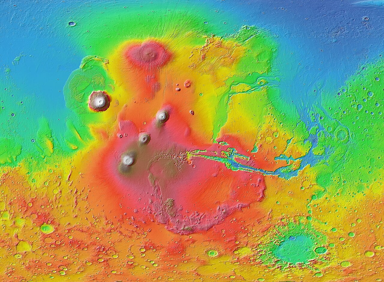
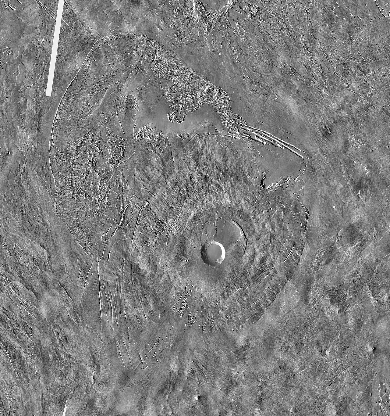

![A low-altitude demonstration and verification flight test for the Long March-10 carrier rocket and the Mengzhou crewed spaceship system. Credit: Xinhua]](https://www.universetoday.com/article_images/118333642_797d8300-9853-408f-a2e3-13c9ab7d990b_20260214_222954.JPG)
![The first stage of the Long March-10 carrier rocket safely splashes down in the predetermined sea area in a controlled manner as planned, Feb. 11, 2026. [Photo/Xinhua]](https://www.universetoday.com/article_images/118333642_9d71b2c8-7c17-493e-ad9f-58e5f23f91a1_20260214_222829.JPG)


:focal(395x395:396x396)/https://tf-cmsv2-smithsonianmag-media.s3.amazonaws.com/filer_public/92/96/9296b51b-94e4-4c66-930e-af4b44172205/earth_cutaway.png)


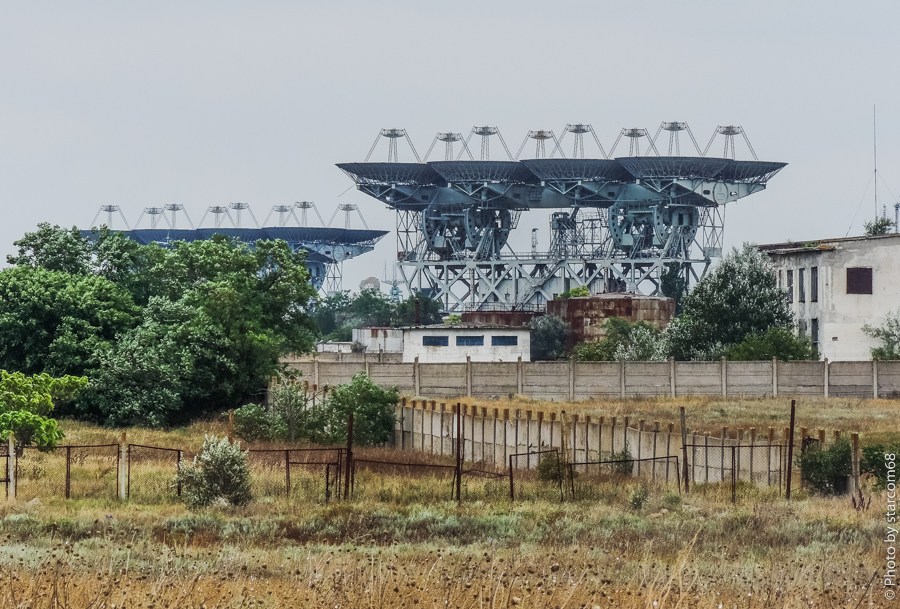


:focal(824x596:825x597)/https://tf-cmsv2-smithsonianmag-media.s3.amazonaws.com/filer_public/10/23/102335b8-9359-488a-8f18-ff937554b693/pia26368orig.webp)