The purpose of this blog is the creation of an open, international, independent and free forum, where every UFO-researcher can publish the results of his/her research. The languagues, used for this blog, are Dutch, English and French.You can find the articles of a collegue by selecting his category. Each author stays resposable for the continue of his articles. As blogmaster I have the right to refuse an addition or an article, when it attacks other collegues or UFO-groupes.
Druk op onderstaande knop om te reageren in mijn forum
Zoeken in blog
Deze blog is opgedragen aan mijn overleden echtgenote Lucienne.
In 2012 verloor ze haar moedige strijd tegen kanker!
In 2011 startte ik deze blog, omdat ik niet mocht stoppen met mijn UFO-onderzoek.
BEDANKT!!!
Een interessant adres?
UFO'S of UAP'S, ASTRONOMIE, RUIMTEVAART, ARCHEOLOGIE, OUDHEIDKUNDE, SF-SNUFJES EN ANDERE ESOTERISCHE WETENSCHAPPEN - DE ALLERLAATSTE NIEUWTJES
UFO's of UAP'S in België en de rest van de wereld Ontdek de Fascinerende Wereld van UFO's en UAP's: Jouw Bron voor Onthullende Informatie!
Ben jij ook gefascineerd door het onbekende? Wil je meer weten over UFO's en UAP's, niet alleen in België, maar over de hele wereld? Dan ben je op de juiste plek!
België: Het Kloppend Hart van UFO-onderzoek
In België is BUFON (Belgisch UFO-Netwerk) dé autoriteit op het gebied van UFO-onderzoek. Voor betrouwbare en objectieve informatie over deze intrigerende fenomenen, bezoek je zeker onze Facebook-pagina en deze blog. Maar dat is nog niet alles! Ontdek ook het Belgisch UFO-meldpunt en Caelestia, twee organisaties die diepgaand onderzoek verrichten, al zijn ze soms kritisch of sceptisch.
Nederland: Een Schat aan Informatie
Voor onze Nederlandse buren is er de schitterende website www.ufowijzer.nl, beheerd door Paul Harmans. Deze site biedt een schat aan informatie en artikelen die je niet wilt missen!
Internationaal: MUFON - De Wereldwijde Autoriteit
Neem ook een kijkje bij MUFON (Mutual UFO Network Inc.), een gerenommeerde Amerikaanse UFO-vereniging met afdelingen in de VS en wereldwijd. MUFON is toegewijd aan de wetenschappelijke en analytische studie van het UFO-fenomeen, en hun maandelijkse tijdschrift, The MUFON UFO-Journal, is een must-read voor elke UFO-enthousiasteling. Bezoek hun website op www.mufon.com voor meer informatie.
Samenwerking en Toekomstvisie
Sinds 1 februari 2020 is Pieter niet alleen ex-president van BUFON, maar ook de voormalige nationale directeur van MUFON in Vlaanderen en Nederland. Dit creëert een sterke samenwerking met de Franse MUFON Reseau MUFON/EUROP, wat ons in staat stelt om nog meer waardevolle inzichten te delen.
Let op: Nepprofielen en Nieuwe Groeperingen
Pas op voor een nieuwe groepering die zich ook BUFON noemt, maar geen enkele connectie heeft met onze gevestigde organisatie. Hoewel zij de naam geregistreerd hebben, kunnen ze het rijke verleden en de expertise van onze groep niet evenaren. We wensen hen veel succes, maar we blijven de autoriteit in UFO-onderzoek!
Blijf Op De Hoogte!
Wil jij de laatste nieuwtjes over UFO's, ruimtevaart, archeologie, en meer? Volg ons dan en duik samen met ons in de fascinerende wereld van het onbekende! Sluit je aan bij de gemeenschap van nieuwsgierige geesten die net als jij verlangen naar antwoorden en avonturen in de sterren!
Heb je vragen of wil je meer weten? Aarzel dan niet om contact met ons op te nemen! Samen ontrafelen we het mysterie van de lucht en daarbuiten.
10-02-2026
Is this why we haven't found aliens yet? Scientists claim looking for planets with water is POINTLESS – and say we should focus on worlds with phosphorus and nitrogen instead
Is this why we haven't found aliens yet? Scientists claim looking for planets with water is POINTLESS – and say we should focus on worlds with phosphorus and nitrogen instead
Scientists hunting for life beyond Earth have long thought that water is one of the key indicators.
But a group of experts now says that looking for life on water–rich planets could be a waste of time.
Instead, they claim we should be turning our telescopes to worlds that are filled with phosphorus and nitrogen.
Life as we know it simply cannot form without these two elements - even if there's abundant water.
Phosphorus is required to make DNA and RNA, which store and transmit genetic information in all lifeforms.
Nitrogen, meanwhile, is an essential component of proteins, which are the basic building blocks of cells.
This means that life can only form on worlds within the 'chemical Goldilocks zone', where there is just the right amount of nitrogen and phosphorus in the rocky mantle.
Lead author Dr Craig Walton, of ETH Zurich, told the Daily Mail: 'You could feasibly have a planet that looks great with oceans and even dry land, but there is no life and never will be because the other elements you need are simply all but absent.'
Scientists say that looking for planets with oxygen might be a waste of time, and we should be looking for planets that formed with abundant phosphorus and nitrogen instead. Pictured: Artist's impression of planets forming around a star
While no life as we understand it can survive without liquid water and oxygen, looking for planets that have these ingredients might be misleading.
This is because a planet's 'oxygen balance' at the moment of its formation determines how much phosphorus and nitrogen remain available for life.
When planets cool out of molten rock, a sorting process happens in which the heavy elements like iron sink towards the core, while lighter ones float to the surface to form the mantle and crust.
If there is too much oxygen present, phosphorus gets locked in the mantle while nitrogen is forced out into the atmosphere and eventually lost into space.
On the other hand, if there is too little oxygen, phosphorus binds with other heavy elements and is dragged down to the core, where it can't be used to kickstart life.
Dr Walton says: 'Having too much or too little oxygen in the planet as a whole – not in the atmosphere per se – makes the planet unsuitable for life because it traps key nutrients for life in the core.
'A different oxygen balance means you have nothing to work with left at the surface when the planet cools and you form rocks.'
Using numerical modelling, the researchers found that there is a very narrow band where there is just enough oxygen for both phosphorus and nitrogen to be abundant in the mantle.
Phosphorus and nitrogen are both essential for life, but only a small number of planets are inside the 'Goldilocks zone' (illustrated) where there is enough of both elements for life to form
What is necessary for life?
Liquid water: A universal solvent that allows the chemistry of life to take place
Oxygen: The primary fuel for producing energy
Phosphorus: Required to make DNA and RNA
Nitrogen: An essential ingredient in proteins
By an incredibly lucky chance, Earth happens to sit right inside the chemical Goldilocks zone, ensuring that it had the right balance for other planets to form.
However, this likely means that habitable worlds are far rarer than astronomers thought.
Dr Walton suggests that there might be just one to 10 per cent as many habitable planets as previously suggested.
That might have serious consequences for how scientists search for life, and how we think about the future of human space exploration.
While we currently see an abundance of oxygen as a sign of habitability, the researchers' calculations suggest this may signal that the world cannot support life.
'It would be very disappointing to travel all the way to such a planet to colonise it and find there is no phosphorus for growing food,' says Dr Walton.
'We'd better try to check the formation conditions of the planet first, much like ensuring your dinner was cooked properly before you go ahead and eat it.'
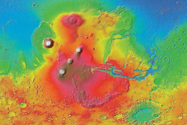
Closer to home, the researchers' findings also suggest that Mars sits just outside of the chemical Goldilocks zone.
Mars (pictured) sits just outside the chemical Goldilocks zone, meaning that it doesn't have enough nitrogen to support life. Huge changes would be needed to make the soil capable of growing plants
Dr Walton says: 'Mars is fairly similar to Earth, and its formation conditions mean there is more phosphorus, not less. This means growing food there might be relatively easy.'
However, other chemicals are also a lot more abundant at the surface, poisoning the soil with harsh salts.
'It is not that different, but it is not currently habitable, Elon Musk will have to come up with a clever way to change the composition to grow food there.'
The Drake Equation is a seven-variable way of finding the chance of active civilizations existing beyond Earth.
It takes into account factors like the rate of star formation, the amount of stars that could form planetary systems, the number potentially habitable planets in those systems.
The equation includes recent data from Nasa's Kepler satellite on the number of exoplanets that could harbor life.
Researchers also adapted the equation from being about the number of civilizations that exist now, to being about the probability of civilization being the only one that has ever existed.
Researchers found the odds of an advanced civilization developing need to be less than one in 10 billion trillion for humans to be the only intelligent life in the universe.
Unless the odds of advanced life evolving on a habitable planet are astonishingly low, then humankind is not the only advanced civilization to have lived.
But Kepler data places those odds much higher, which means technologically advanced aliens are likely to have existed at some point.
International Crew-12 prepares for expedited flight to ISS
International Crew-12 prepares for expedited flight to ISS
Story by Brooks Mendenhall
International Crew-12 prepares for expedited flight to ISS
Mission Highlight: Crew-12
NASA and SpaceX are targeting Wednesday, Feb. 11, at 5:38 a.m. EST for the launch of the Crew-12 mission from Space Launch Complex 40 at Cape Canaveral Space Force Station in Florida. The flight will carry an international team to the International Space Station (ISS), including NASA astronauts Jessica Meir (commander) and Jack Hathaway (pilot), European Space Agency (ESA) astronaut Sophie Adenot, and Roscosmos cosmonaut Andrey Fedyaev. The crew will fly aboard the Crew Dragon Freedom spacecraft, the fifth flight for the craft, which previously carried the Crew-4 and Crew-9 missions.
The launch follows the recent early return of the Crew-11 astronauts due to a medical situation, a shift that temporarily left the space station with a reduced crew and only one American aboard, NASA astronaut Chris Williams. To restore the station's research capacity, NASA and SpaceX worked to move Crew-12 launch up from its Feb. 15 launch window. “It was a little bit more hectic for us than it normally would have been, but we fit everything in that we needed to,” Meir said in a Feb. 8 press conference, noting that the team adjusted its training to account for the expedited schedule.
During their long-duration stay, the crew will focus on science and technology demonstrations that prepare humanity for deep-space exploration, including a new exercise machine. ESA's Enhanced Exploration Exercise Device (E4D) is a compact device that the entire crew will test during the mission. The E4D offers a wider range of exercise options than current equipment, including a rope system to allow astronauts to train pulling movements. The machine also features built-in cameras for immediate feedback and performance tracking, and serves as a technology demonstrator for the future Lunar Gateway.
Some of the crew will also participate in so-called "Manual Piloting" simulations. In an emergency, astronauts traveling to the moon or Mars might be required to land their spacecraft manually. The transition in gravity during that landing could be disorienting, especially after spending the duration of the flight in microgravity. To test how astronauts will handle this, members of Crew-12 will complete simulated lunar landings before, during, and after their stay on the ISS. These simulations will hopefully reveal how microgravity impacts the ability to safely land a vehicle on the moon. As Meir explained in the Feb. 8 press conference, “You’re looking at your fuel. You know, you’re steering over to your landing site. The goal … is to understand what these gravitational transitions will do to a human’s ability to perform those kinds of activities."
Other missions this week
On Wednesday, Feb. 11, SpaceX is scheduled to launch the Starlink Group 17-34 mission from Vandenberg Space Force Base in California at 9:07 a.m. EST. The Falcon 9 first-stage booster will attempt a landing on the droneship Of Course I Still Love You in the Pacific Ocean.
On Thursday, Feb. 12, a Jielong 3 rocket is scheduled to lift off from the Haiyang Oriental Spaceport in China at 1:30 a.m. EST, carrying an unknown payload into orbit for Chinarocket.
Later in the morning, a Vulcan VC4S rocket is scheduled to launch from Cape Canaveral Space Force Station on Thursday, Feb. 12, at 3:30 a.m. EST. This mission, designated USSF-87, will deploy the Geosynchronous Space Situational Awareness Program (GSSAP) 7 and 8 satellites for the United States Space Force to enhance its space surveillance.
On the other side of the globe, Roscosmos is preparing a Proton-M rocket to launch the Elektro-L n°5 weather satellite from the Baikonur Cosmodrome in Kazakhstan on Thursday, Feb. 12 at 3:52 a.m. EST.
Wrapping up Thursday's busy launch schedule, Arianespace will debut the Ariane 64 rocket (a more powerful variant of the Ariane 6) from the Guiana Space Centre in French Guiana at 11:45 a.m. EST, carrying a large-scale deployment of satellites for Amazon's Project Kuiper – a first for Arianespace.
Closing out the week on Valentine's Day, Saturday, Feb. 14, a couple of Starlink launches take flight. The first will lift off from Cape Canaveral at 12:00 a.m. EST with the booster slated to land on the droneship A Shortfall of Gravitas, followed by a second launch from Vandenberg at 5:00 p.m. EST targeting a landing on Of Course I Still Love You.
Last week's recap
The first week of February was defined by a steady cadence of launches.
On Monday, Feb. 2, SpaceX successfully launched the Starlink Group 17-32 mission from Vandenberg at 10:47 a.m. EST. This was followed on Thursday, Feb. 5, by a Russian military launch as a Soyuz 2.1b sent a classified Cosmos payload into orbit from the Plesetsk Cosmodrome at 1:59 p.m. EST.
On Friday, Feb. 6, China Aerospace Science and Technology Corporation (CASC) launched an experimental spaceplane aboard a Long March 2F rocket from the Jiuquan Satellite Launch Center at 10:58 p.m. EST. The Chinese government has kept information about the mission and the vehicle relatively secret, but it’s thought to be modeled after the U.S. Space Force's X-37B. This mission marks its fourth launch, with previous flights appearing to deploy small companion satellites while in orbit, according to reporting from Space News. The week concluded on Saturday, Feb. 7, with SpaceX launching the Starlink Group 17-33 mission from Vandenberg at 3:58 p.m. EST.
Looking ahead
On Tuesday, Feb. 17, SpaceX is slated to launch the Starlink Group 10-36 mission from Cape Canaveral at 5:00 p.m. EST.
On Wednesday, Feb. 18, the SpaceX cadence continues with the Starlink Group 17-25 mission launching from Vandenberg at 3:00 a.m. EST. Later that evening, Firefly Aerospace is scheduled to launch its Alpha rocket on the “Stairway To Seven” mission from Vandenberg at 7:50 p.m. EST.
On Thursday, Feb. 19, SpaceX is targeting 9:56 p.m. EST for the launch of the Starlink Group 6-104 mission from Cape Canaveral.
On Friday, Feb. 20, the Indian Space Research Organisation (ISRO) is scheduled to launch the EOS-05 Earth observation satellite aboard a GSLV Mk II rocket from the Satish Dhawan Space Centre at 5:30 a.m. EST.
James Webb Telescope uncovers key ingredients for life in galaxy over 10 billion light years away
James Webb Telescope uncovers key ingredients for life in galaxy over 10 billion light years away
Story by Lydia Amazouz
Image credit: Mikulski Archive for Space Telescopes, Space Telescope Science Institute, Association of Universities for Research in Astronomy, Inc., NASA. | The Daily Galaxy --Great Discoveries Channel
In a groundbreaking study published in the journal Nature, astronomers using the James Webb Space Telescope (JWST) have uncovered a surprising array of organic molecules in a distant galaxy, IRAS 07251–0248. This discovery offers fresh insights into the early stages of life’s building blocks, revealing how complex molecules may form in extreme regions of space. The JWST’s unprecedented ability to detect infrared light allowed scientists to peer into this galaxy’s obscured heart, unveiling an astonishing chemical diversity that could play a crucial role in understanding the origins of life beyond Earth.
The Unexpected Chemical Complexity
The JWST’s investigation of IRAS 07251–0248, an ultra-luminous infrared galaxy, has provided scientists with an invaluable snapshot of molecular chemistry in a distant galactic environment. The galaxy, known for its dense core shrouded in dust and gas, emits a significant amount of infrared light, which the JWST can detect without obstruction. This allowed researchers to analyze the chemical composition of the galaxy’s gas, dust, and ice.
“We found an unexpected chemical complexity, with abundances far higher than predicted by current theoretical models,” said Ismael García Bernete, team leader and researcher at the Center for Astrobiology (CAB).
The team’s results indicated a significantly richer chemical network than what had been anticipated. This suggests that some galactic nuclei may harbor a continuous source of carbon, fueling the chemical processes needed for the creation of organic molecules. This discovery challenges prior assumptions about the amount and distribution of complex organic material in such extreme environments, suggesting a far more abundant molecular production than previously thought.
Among the wealth of chemicals identified, several small organic molecules stood out, including methane, acetylene, benzene, and the highly reactive methyl radical. These molecules are often considered the basic building blocks for life, forming the foundational components needed to create more complex organic compounds. The discovery of these molecules in a distant galaxy could revolutionize our understanding of how life-sustaining compounds form in space.
Despite the fact that small organic molecules like those found in IRAS 07251–0248 are not present in living cells, they hold significant potential for prebiotic chemistry. “Although small organic molecules are not found in living cells, they could play a vital role in prebiotic chemistry, representing an important step towards the formation of amino acids and nucleotides,” explained Dimitra Rigopoulou, a team member from the University of Oxford. This suggests that these simple compounds could serve as crucial intermediaries in the formation of more complex molecules required for life as we know it.
Technicians lift the mirror of the James Webb Space Telescope using a crane at the Goddard Space Flight Center in Greenbelt, Md (2017).
Credit: NASA via AP
Cosmic Rays and Their Role in Organic Chemistry
The team’s findings also pointed to the role of cosmic rays in shaping the chemical environment of this galaxy. While extreme temperatures and the stirring of gases could explain some of the molecular complexity observed, the researchers hypothesize that high-energy particles, known as cosmic rays, may play a pivotal role. These particles likely bombard and fragment larger molecules, such as carbon-rich grains of dust, breaking them into smaller organic molecules in the process. This cosmic chemistry adds a layer of complexity to the creation of organic compounds in space, emphasizing the importance of high-energy processes in the molecular evolution of the universe.
Copyright Credit: NASA/ESA/CSA/JPL-Caltech/M. Sewiło et al. (2025)
Implications for Life Beyond Earth
The significance of these findings extends far beyond this specific galaxy. The discovery that organic molecules can form and accumulate in distant, chemically-rich galactic environments presents a compelling case for the potential of life elsewhere in the universe. The study not only demonstrates how galaxies like IRAS 07251, 0248 might act as “factories” for organic molecules but also highlights the role that cosmic processes play in the formation of the building blocks of life. As such, this research could guide future investigations into the chemical evolution of other galaxies and planetary systems, especially those with the necessary conditions for life.
Published in Natureon February 6, the study underscores the power of the JWST in studying distant and previously obscured regions of space. With its ability to penetrate dense cosmic dust and gather data on far-off molecular structures, the JWST is set to reshape our understanding of the universe’s chemical landscape, potentially uncovering new pathways for the origins of life.
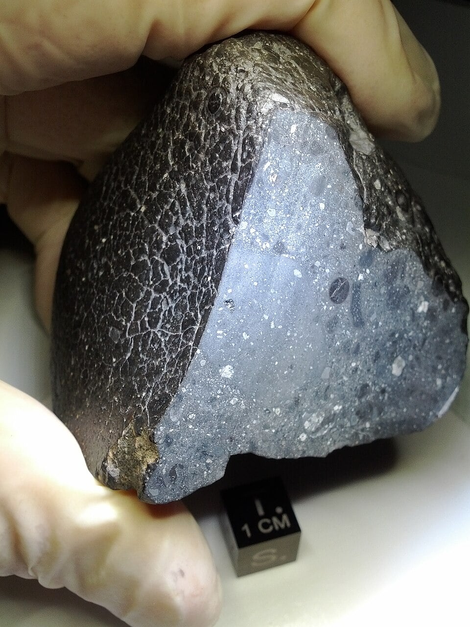
Non-biological sources cannot fully explain the abundance of organic compounds in the sample studied by the Curiosity rover. This is stated in an article published on February 4 in the journal Astrobiology.
Selfie taken by the Curiosity rover. Source: NASA/JPL-Caltech/MSSS
In March 2025, scientists reported finding small amounts of decane, undecane, and dodecane in a rock sample analyzed by the Curiosity rover. These were the largest organic compounds ever found on Mars. Researchers have hypothesized that they may be fragments of fatty acids preserved in ancient clay shale in Gale Crater. On Earth, fatty acids are mainly produced by living organisms, although they can also be formed as a result of geological processes.
According to Curiosity, it was impossible to determine whether the molecules found were produced by living organisms. Therefore, scientists conducted a study in which they evaluated known non-biological sources of these organic molecules, such as meteorites that fell on the surface of Mars.
In their report, the researchers stated that the non-biological sources they examined cannot fully explain the abundance of organic compounds. Therefore, it is reasonable to assume that they could have been formed by living organisms.
To reach this conclusion, scientists combined the results of radiation experiments, mathematical modeling, and data from Curiosity. As a result, they “rewound time” by approximately 80 million years — the period during which the rock could have been exposed on the surface of Mars. This made it possible to estimate how much organic material could have been present before it was destroyed by prolonged exposure to cosmic radiation: much more than could have been produced by typical non-biological effects.
According to the research team, further studies are needed to better understand how quickly organic molecules decompose under Martian conditions. After that, it will be possible to draw any conclusions about the absence or presence of life on the Red Planet.
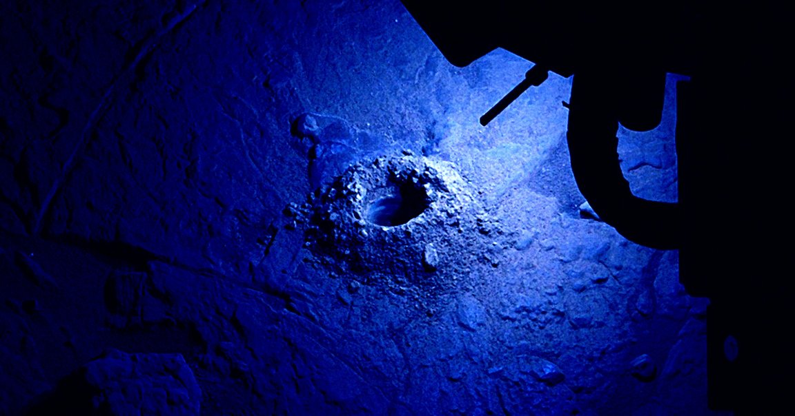
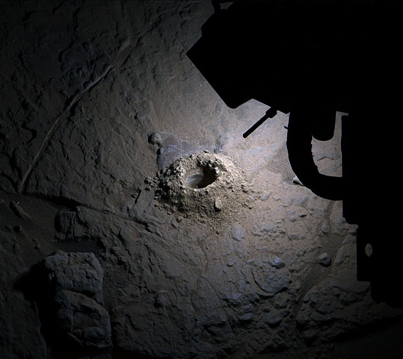
Scientists from the University of Trento have proven for the first time the existence of an empty lava tube beneath the surface of Venus. The discovery was made thanks to analysis of radar data from the Magellan mission.
Lava tube on Venus (concept). Source: RSLab, University of Trento
Volcanic activity is not unique to Earth: traces of it have been found on Mars and the Moon. These includelava tubes— natural subsurface channels formed by the uneven cooling of lava, when the solidified crust conceals the liquid flow, leaving voids after the source has been depleted.
Since Venus’ surface and geology are largely shaped by volcanic processes, it is logical to assume that lava tubes must also exist there. However, finding them is a very difficult task. Since the tubes are formed underground, they usually remain hidden and can only be detected if part of their arch collapses, creating a pit visible on the planet’s surface. In the case of Venus, the situation is further complicated by the fact that the planet’s surface is always hidden by thick clouds. Therefore, scientists can only rely on radar data.
To solve this problem, a team of researchers from the University of Trento turned to archival data from the Magellan mission: between 1990 and 1992, it used radar to compile the most detailed map of Venus’ surface to date. Using the visualization technology they developed, the scientists analyzed radar images showing signs of local surface collapses.
Radar map of the surface of Venus with a pit marked on it, caused by a collapse of the dome. Source: Nature Communications, DOI: 10.1038/s41467-026-68643-6
The analysis revealed the existence of a large underground channel in the Nyx Mons region, named after the Greek goddess of the night. Scientists interpreted the structure as a possible lava tube with an estimated diameter of about one kilometer, a vault thickness of at least 150 meters, and a depth of at least 375 meters.
The lava tube that has been discovered appears to be wider and taller than those observed on Earth or predicted for Mars. It is at the upper end of the range that scientists had predicted (and in one case actually observed) on the Moon. This is not surprising, since Venus has lower gravity and a denser atmosphere than Earth. This promotes the rapid formation of a thick insulating crust immediately after the lava flows out of the vent.
According to scientists, analysis of the morphology and elevation of the surrounding terrain, as well as the presence of other pits similar to the one under investigation, confirm the hypothesis that subsurface channels on Venus may extend for at least 45 kilometers. New, higher-resolution images and subsurface radar data will be needed to verify this and identify additional lava tubes. They are expected to be obtained by the Envision and Veritas missions, which are scheduled to launch in the next decade.
A massive subsurface structure has been discovered on Venus, according to astronomers relying on radar data analysis.
The large underground feature is believed to be a remnant of ancient volcanic activity that once proliferated on the nearby planet. In the past, similar evidence of ancient lava tubes has been discovered on both the Mars, and even on Earth’s moon.
The findings, reported by astronomers with the University of Trento in the journal Nature Communications, say their discoveries are shedding new light on the geology that shaped Venus through volcanic activity over time.
Lorenzo Bruzzone, who coordinated the recent research, said that this represents the first opportunity astronomers have had to glimpse such processes occurring beneath Venus’s surface.
“Our knowledge of Venus is still limited, and until now we have never had the opportunity to directly observe processes occurring beneath the surface of Earth’s twin planet,” Bruzzone said in a statement. “The identification of a volcanic cavity is therefore of particular importance, as it allows us to validate theories that for many years have only hypothesized their existence.”
A full professor of Telecommunications and head of the Remote Sensing Laboratory at the Department of Information Engineering and Computer Science of the University of Trento, Bruzzone says the discoveries he and his colleagues have made contribute significantly to our understanding of “the processes that have shaped Venus’s evolution and opens new perspectives for the study of the planet.”
Extraterrestrial Lava Tubes
One of the major hurdles to making such discoveries is the difficulty of locating subsurface features on planets other than Earth. Naturally, lava tubes and other hollow structures located beneath a planet’s surface remain invisible to not only the eye, but also a range of remote detection capabilities.
However, there are instances in which such features can be revealed. If thin portions of a planet or moon’s surface located above subsurface cavities caves in, it can sometimes reveal the empty conduit below. Such conditions have led to several discoveries of what are referred to as “skylights” on the lunar surface, indicating the lava tubes below.
However, unlike the lunar surface, which can be readily observed in the absence of weather around Earth’s natural satellite, Venus is shrouded in clouds that make observing its surface extremely challenging.
Radar, on the other hand, offers a useful approach toward collecting data about the lunar surface. For a two-year-period beginning in 1990, observations of Venus were made using a Synthetic Aperture Radar (SAR) system aboard NASA’s Magellan spacecraft, which the space agency used to map the surface of Venus.
The decades-old SAR analysis of Venus, Bruzzone said, revealed evidence of areas where similar surface collapses to the lunar “skylights” could be discerned with the help of a novel imaging technique he and his colleagues employed.
“Our analyses revealed the existence of a large subsurface conduit in the region of Nyx Mons,” Bruzzone said. “We interpret the structure as a possible lava tube (pyroduct), with an estimated diameter of approximately one kilometer, a roof thickness of at least 150 meters and an empty void deep of no less than 375 meters.”
Intriguingly, the Venusian lava tube Bruzzone and colleagues discovered is wider and taller than those found on Earth, the Moon, or Mars, and “analysis of the morphology and elevation of the surrounding terrain, together with the presence of other pits similar to the one studied, supports the hypothesis that the subsurface conduits may extend for at least 45 kilometers.”
Bruzzone adds that the team’s imaging technique could help to soon reveal similar features beneath the surface of Venus during future missions, and potentially on other planets as well.
“The results of this study are therefore very important for future missions to Venus, such as the European Space Agency’s Envision and NASA’s Veritas,” Bruzzone said.
“Both spacecraft will carry advanced radar systems capable of capturing higher-resolution images, allowing scientists to study small surface pits in greater detail.”
The team’s recent study, “Radar-based observation of a lava tube on Venus,” was published in Nature Communications.
Micah Hanks is the Editor-in-Chief and Co-Founder of The Debrief. A longtime reporter on science, defense, and technology with a focus on space and astronomy, he can be reached atmicah@thedebrief.org. Follow him on X @MicahHanks, and at micahhanks.com.
A bizarre-looking series of features on the Moon, captured in NASA imagery, appears to resemble the pathway of an enormous serpent slithering across the lunar surface.
At a glance, the peculiar “sinuous” feature could easily leave one with the impression that some large object had tumbled along the lunar landscape, leaving a long path of disturbances behind it.
Originally captured by cameras aboard the Lunar Reconnaissance Orbiter (LRO) in 2020, the snakey surface feature was discovered near Gruithuisen K crater at lunar coordinates 34.5°N, 43.5°W and initially prompted questions among scientists about what might have caused it.
“What is this strange feature consisting of ridges and elliptical and curved pits?” remarked Megan Henriksen, a project manager with Intuitive Machines and part of the team with NASA’s LRO Camera Science Operations Center in Phoenix, Arizona, in a posting on October 6, 2023.
Above: The unusual series of features observed in LROC imagery located near Gruithuisen K crater (Image Credit: NASA/GSFC/Arizona State University).
However, according to NASA officials, the solution to this oddball lunar discovery has nothing to do with mysterious surface activity and instead involves the Moon’s unique geology and subsurface features.
Answers Emerge from Below
The most likely explanation for the mysterious serpentine surface feature at Gruithuisen K involves ancient lunar volcanic activity.
Ancient eruptions of basaltic lava on the Moon have given rise to the formation of lava tubes, many of which have already been documented in various places on the Moon’s surface. As flowing lava cools and crusts, it provides insulation for the lava within, which eventually passes through once the primary eruption event subsides, leaving these long, tubular formations that gradually become buried over time—processes that are also well-characterized here on Earth.
Most evidence for the presence of lava tubes on the Moon appears in the form of what are known as “skylights,” which are areas above these ancient subsurface tunnels that collapse either due to the forces of gravity, or sometimes with the aid of seismic events, or even a well-placed meteor impact on the lunar surface.
In the case of the snaking surface features found near Gruithuisen K, lunar scientists believe that a lava tube located a short distance beneath the Moon’s surface resulted in an unusual “chain” of depressions as a series of collapses occurred along the tube over time.
“The large irregularly shaped crater-like formation at the upper left of the image is potentially the source vent for the lava flow,” Henriksen noted in 2023. “If there are lava tubes at Gruithuisen K, they could be as wide as 500 meters!”
Establishing lunar bases within lava caves could also provide protection for astronauts in the coming decades. For instance, these caves could provide thermal insulation against the wide temperature fluctuations that occur there, in addition to shielding lunar scientists from the harmful effects of cosmic radiation.
Lunar outposts positioned within these caves may also help protect against meteorite impacts that have scoured the Moon’s surface, resulting in its characteristic pockmarked appearance.
So altogether, subsurface lava tubes on the Moon like those at Gruithuisen K are more than just a novelty for lunar enthusiasts: in the future, they may also be able to offer shelter to astronauts conducting long-term studies there, in addition to helping reveal important details about the Moon’s geology and volcanic history.
Micah Hanks is the Editor-in-Chief and Co-Founder of The Debrief. A longtime reporter on science, defense, and technology with a focus on space and astronomy, he can be reached atmicah@thedebrief.org. Follow him on X @MicahHanks, and at micahhanks.com.
Plenty of asteroids can survive their fiery plunge through the Earth’s atmosphere. If they’re big enough, they can prove incredibly destructive, like the 60-foot Chelyabinsk meteor that exploded over the southern Ural region in Russia in 2013, releasing a blastequivalent to 30 timesthe energy of the atomic bomb that was dropped on Hiroshima.
And in case an even larger space rock were to ever threaten humanity, we’d have to get creative to keep it from colliding with our planet. Crashing a spacecraft into it like a pool ball to redirect its path — just like NASA did with its proof of concept Double Asteroid Redirection Test (DART) mission in 2022— may not always be on the table, given the many uncertainties involved.
In a new paper published in the journal Nature Communications, an international team of researchers — including scientists from CERN and the University of Oxford — revisited the idea of blowing up an incoming asteroid with a nuclear warhead.
There are intuitive concerns. What if the asteroid shattered, turning a cosmic sniper shot into a shotgun blast of debris raining down over our planet?
But the team used CERN’s Super Proton Synchrotron (SPS) to study how asteroid materials react to different levels of physical stress, including large-scale simulations of nuclear deflection, and found that the space rocks are surprisingly resilient.
“Planetary defense represents a scientific challenge,” said Karl-Georg Schlesinger, cofounder of nuclear deflection startup Outer Solar System Company (OuSoCo), which partnered with the scientists, in a statement. “The world must be able to execute a nuclear deflection mission with high confidence, yet cannot conduct a real-world test in advance.”
In an experiment, the team exposed samples of a metal-rich meteorite to 27 short but intense pulses of a proton beam at CERN’s HiRadMat facility. Afterward, the team moved the meteorite to the ISIS Neutron and Muon Source at the Rutherford Appleton Laboratory in the UK to analyze changes to its internal structure at a microscopic level.
To their surprise, the “material became stronger, exhibiting an increase in yield strength, and displayed a self-stabilizing damping behavior,” explained OuSoCo cofounder Melanie Bochmann.
The finding could have major implications for how we approach future asteroid redirection efforts.
“Our experiments indicate that — at least for metal-rich asteroid material — a larger device than previously thought can be used without catastrophically breaking the asteroid,” Bochmann said. “This keeps open an emergency option for situations involving very large objects or very short warning times, where non-nuclear methods are insufficient and where current models might assume fragmentation would limit the usable device size.”
Fortunately, the researchers could soon have far more data to go by. Both NASA and the European Space Agency are planning to study Apophis, an enormous asteroid somewhere between 1,000 and 1,500 feet in width, which is expected to come eerily close to the Earth — closer than many geosynchronous satellites at just 20,000 miles — to Earth in April 2029.
“As a next step, we plan to study more complex and rocky asteroid materials,” the researchers said in a statement. “One example is a class of meteorites called pallasites, which consist of a metal matrix similar to the meteorite material we have already studied, with up to centimeter-sized magnesium-rich crystals embedded inside.”
The upcoming research could have fascinating implications outside of asteroid redirection as well.
“Because these objects are thought to originate from the core–mantle boundary of early planetesimals,” they added, “such experiments could also provide valuable insights into planetary formation processes.”
From time to time, ice ages occur on Earth, during which the appearance of our planet changes significantly. During these periods, large areas of land are covered with a layer of ice that does not melt even in summer. Scientists do not know all the reasons behind this phenomenon, but they have long been aware of its mechanisms and have several good theories that could explain everything.
What causes ice ages?
Ice on Earth
One of the main features of Earth as a planet in the Solar System is that it changes its appearance significantly as it revolves around our star. In regions where winter prevails at a given moment, water turns into snow and ice, covering vast areas of the surface. This is especially noticeable in the temperate zone of the Northern Hemisphere, as this is where the largest land masses are concentrated.
Earth is not unique in this regard, as Mars experiences the same changes, albeit on a smaller scale. There are areas of land on Earth that are permanently covered with ice regardless of the season, but this mainly applies to Antarctica, Greenland, and some high-altitude regions. However, there were times in the past when snow and ice covered a much larger area throughout the year.
We know them as the Ice Age. This term usually refers to the part of the Pleistocene epoch that began 2.53 million years ago and continues to this day. However, it is neither the only such event in the history of the Earth, nor the longest or the most extensive, but it is the best known to the general public and the best studied by scientists.
Earth during winter in the Northern Hemisphere. Source: phys.org
It is interesting to note that the idea of a period in our planet’s past when even modern Central Europe had a climate similar to that of northern Siberia today is relatively new. Even in the days of Galileo and Copernicus, no one suspected such a thing. It all began in the 17th century, when researchers turned their attention to so-called erratic boulders – large boulders found far from their parent rock, sometimes in the middle of a forest.
People already knew back then that such boulders often remain on the slopes of the Alps in spring after the ice has receded far into the mountains. But similar stones were found even deep in the valleys, where the ice did not reach in winter.
Subsequently, such rounded boulders began to be found not only in the Alps but also in Scandinavia, and the idea arose that once upon a time the whole continent was covered with ice. Later, the same conclusion was made about most of Europe in general. In the second half of the 19th century, the idea of the Ice Age as part of Earth’s past gained widespread recognition.
Erratic stone. Source: Wikipedia
What was the last ice age like?
It should be noted that the idea of the last ice age as a period when the Earth froze 2.5 million years ago and then melted almost instantly 10,000 years ago is, in principle, incorrect.
Yes, the climate did become much colder. Glaciers covered Belarus, Scandinavia, and Scotland, but further south, in the place of modern-day London and Paris, there was tundra. This meant that snow lay on the ground for most of the year, but it melted for a few summer months, and then the land was covered with cold-resistant vegetation. Where the climate was slightly wetter and warmer, there were taiga – cold coniferous forests. Roughly the same picture was observed in North America.
Further south, where the warm Mediterranean now stretches, there was a temperate climate, and beyond that were warm and even hot countries. Yes, the average temperature on the planet was significantly lower than it is now, but in tropical and equatorial zones, this effect was not very pronounced. In many regions, precipitation was significantly higher than it is today, although its distribution remained roughly the same as it is now.
Climate during the last glacial maximum. Source: Wikipedia
At the same time, the entire picture described above refers to the peaks of glaciation, which during the Quaternary period were not constant but were interrupted by interglacial periods. These periods lasted up to several tens of thousands of years, during which the climate was remarkably similar to what it is now. The ice fields retreated to the poles, and the former tundra turned into mixed forests and steppes.
In general, it is worth noting that the Quaternary glaciation has not yet come to an end. The climate that currently prevails on Earth is just another interglacial period. It is quite possible that in a few tens of thousands of years, the glaciers will begin to advance again.
Feedback system
But why is this happening, and why are scientists sure that this is not the end of the ice age, but just a break in it? The answer to this question is pretty complicated, not least because the Quaternary glaciation is not the first in Earth’s history; we know way less about the past ones, and there is no guarantee that they had the same root causes.
Europe during the last glacial maximum. Source: Wikipedia
However, scientists have a fairly good understanding of the mechanisms that control the course of such an event once it has begun. Direct and reverse feedback mechanisms begin to operate.
Water ice is a material with high heat capacity for heating and melting. No wonder it is used to cool drinks. For a cubic kilometer of ice to melt, it must absorb a huge amount of energy from the surrounding land, water, and air.
In addition, ice has a high albedo. To see this for yourself, just step outside on a sunny winter day. Therefore, even a fraction of a percent increase in the area of glaciers on our planet is enough to significantly increase the amount of solar energy reflected into space. At the same time, the part that remains in the atmosphere and hydrosphere is absorbed by the same ice.
This creates conditions for the formation of even more ice. As a result, the area of glaciers grows from year to year: slowly at first, and then faster and faster as the process of their expansion accelerates.
Isotopic composition of the atmosphere over the last 140,000 years. Source: Wikipedia
Why, then, do glaciers not cover the entire Earth, and why does the cold era eventually come to an end? Because, in addition to direct mechanisms, there is also a reverse mechanism at work. Greenhouse gases are present in the Earth’s atmosphere. The strongest of these are carbon dioxide (carbonic acid gas) and water vapor. The former is constantly replenished by volcanoes and forest fires, the latter by evaporation from the surface of the oceans.
Carbon dioxide is absorbed by plants and certain types of rock, while water vapor is converted into precipitation. In the early stages of glaciation, the amount of the former remains unchanged, while the amount of the latter actually decreases due to the overall drop in global temperatures.
But as glaciers spread, temperature fluctuations in the atmosphere decrease, winds weaken, and precipitation decreases. The cold and dry climate prevents plants from growing, and they begin to absorb less carbon dioxide. And volcanoes have no intention of ceasing their activity.
The melting of ice consumes a huge amount of energy. Source: www.livescience.com
At some point, the content of carbon dioxide, followed by water vapor, in the atmosphere begins to increase, and now they demonstrate a positive correlation. The more there is, the faster it accumulates. The albedo and heat capacity of glaciers become weaker than those of relatively warm and humid air, and they begin to melt faster than they form. Therefore, their area shrinks quite quickly, the planet’s albedo decreases, and an interglacial period begins.
These assumptions are consistent with geological data. Temperature and chemical composition of the air leave many traces in rocks and fossilized trees. It is easy to construct graphs of these traces and see how this works.
Milankovitch cycles
But what is the root cause of these changes, the impetus that causes glaciers to cross the threshold beyond which the above-described processes begin? There is no exact answer to this question, but the most plausible explanation is the observation made by Serbian astronomer Milutin Milankovitchin the 1940s.
Precession of the Earth’s orbit. Source: Wikipedia
The shape of Earth’s orbit can change over time from almost perfectly circular to slightly elliptical. This is due to the influence of other planets, which is described by complex dependencies. At the same time, the axis of rotation of our planet undergoes precession, i.e., a very slow change in its orientation and orbit, i.e., the direction in which it is tilted relative to the Sun.
As a result, over tens of thousands of years, the relative positions of the Earth’s aphelion – the farthest point in its orbit – and the moment of maximum inclination of one of the poles toward the sun change. We call the latter phenomenon the solstice, and depending on which hemisphere we are in, it can be winter or summer.
But it is not only this time that changes, but also the distance between the Earth and the Sun at the moment of aphelion. Milankovitch drew attention to how small the angle at which the sun’s rays fall on the polar regions of our planet becomes. Could it be that at some point it becomes so small that most of them are simply reflected by the atmosphere, and the amount of heat received by polar glaciers becomes minimal, creating conditions for a sharp increase in their amount?
Milankovitch compared graphs of changes in the angle of incidence of rays and temperatures on Earth over the last two million years and saw that they were extremely similar. We still do not know whether the cycles named after the Serbian scientist are only the “trigger” for glaciations or whether they control them all the time, but no one doubts that they played an important role in this process. And it is precisely the repeatability of the Milankovitch cycles that gives us confidence that the last glaciation was not actually the last.
Earth temperature fluctuations from the Mesozoic era to the present day. Source: phys.org
Past ice ages
The combination of Milankovitch cycles and the mechanisms of direct and reverse feedback between ice and the atmosphere provides a good explanation for the last ice age. However, if we look at the entire history of our planet, many more questions arise.
This is because the fluctuations that can be more or less confidently explained by them arose about 35 million years ago. And within these last millions of years, the change of eras did not always occur. Before that, for hundreds of millions of years, the Earth had a warm and stable climate.
And if all this does not seem strange enough to you, there were other ice ages before that, which were followed by equally long warm periods. And the most severe glaciation in Earth’s history, known as Snowball Earth, occurred during the Proterozoic eon. More precisely, there were two of them: the Stertian, 717–660 million years ago, and the Marionian, 650–635 million years ago.
Snowball Earth. Source: Wikipedia
Unfortunately, due to the remoteness of these events, we know nothing about any short-lived interglacial periods that may have existed within them. However, the fact that the glaciers reached the equator at that time suggests that the simple and understandable mechanisms described above did not work or did not work properly.
This is very surprising because the heat capacity and albedo of ice could not have changed during this time. Moreover, there is little convincing evidence that our planet’s orbit has also changed.
Movement of continents
There are many ideas about possible additional mechanisms of glaciation. The most convincing among them is the hypothesis that the degree of influence of Milankovitch cycles and climatic feedback mechanisms is largely determined by the location of the continents.
The Earth in the Mesozoic era. Source: Wikipedia
The fact is that continents act as heat and cold concentrators. Ice melts faster at sea than on land. Just look at Greenland and Antarctica, where most of the ice is concentrated. At the same time, the hottest deserts are located in the interior of the continental masses of Eurasia and Africa.
The continents themselves move very slowly along with the continental plates, compressing and forming bridges between them. That is, if all the land were gathered into a single mass stretching from pole to pole and blocking all ocean currents, it would be the ideal moment for the onset of an ice age. On the other hand, if there are several small continents scattered across the tropical and temperate zones of both hemispheres, and both poles and the equator remain free, ocean currents balance the climate across the planet.
Of course, these are two extreme ideal scenarios, which are extremely difficult to achieve given the chaotic movement of lithospheric plates. But the closer the actual position of the continental plates is to one or the other scenario, the greater the chance that the influence of Milankovitch cycles will or will not be felt. At least, data on the last few million years of our planet’s history can be well explained by this pattern, including the last 35 million years, during which we have had a giant refrigerator at the South Pole in the form of Antarctica.
Antarctica. Source: Wikipedia
The formation of mountains
There is another factor related to the movement of tectonic plates that may influence the likelihood of the onset of an ice age. When pieces of the lithosphere collide, it can happen relatively quietly, or it can be accompanied by the formation of massive mountain ranges. The last 65 million years, which we call the Cenozoic era, have been just such an epoch.
The fact is that when lithospheric plates collide, rocks that were previously hidden underground and had no contact with the atmosphere come to the surface. And the most chemically active components of the latter are carbon dioxide and water vapor.
That is, when active hill formation occurs, it should lead to the absorption of greenhouse gases. At least that is how it should happen in theory, but it is still unclear whether the volume of rock released from under the Earth is sufficient to significantly affect the composition of the atmosphere.
The Alpine belt is a mountain range that formed during the Cenozoic era. Source: Wikipedia
Astronomical reasons
Finally, when discussing the root causes that can trigger glaciation processes, it is impossible not to mention purely astronomical reasons. The first thing that comes to mind is the change in the Earth’s orbit over long periods of time. This idea is extremely logical and can explain everything without introducing additional entities.
The only problem is that all generally accepted models show that planetary orbits, except for a short period immediately after their formation, remained stable. Some studies suggest that the Earth’s orbit could indeed have changed more than is commonly believed under the influence of Jupiter and Saturn, but these assumptions remain unconfirmed.
However, one event that could have truly influenced glaciation is that the Sun may have been several tens of percent less bright than it is now during the first billion years of its existence. This is quite normal for stars similar to it.
Luminosity, radius, and temperature of the Sun. Source: Wikipedia
And a weak Sun is perfect for explaining why glaciation in the Proterozoic was so extensive. But it cannot be the only and exhaustive explanation for all such processes.
There are other, much more exotic assumptions about the causes of glaciation related to space. For example, the Sun encountered a shock wave from a supernova on its way, and that gas and dust somehow affected the amount of heat our planet received. However, such assumptions remain marginal.
Global warming
The onset of an ice age is caused by several very diverse factors. And here a logical question arises: how does human economic activity affect these processes? First of all, this concerns the emission of large amounts of greenhouse gases by our industry and transport.
Change in average temperature on Earth over the last 140 years. Source: Wikipedia
This fact is usually presented in a negative light. But is it possible that this process could actually delay the onset of a new ice age in the future? If so, then it should be viewed as positive.
In fact, there is no definite answer to this question. The same applies to the question of what role natural processes of transition from glaciation to interglaciation, which are not yet complete, play in global warming.
Scientists can only speculate that the increase in greenhouse gases in the atmosphere may reduce the impact of Milankovitch cycles on the climate, as was the case during warm periods. However, we will only find out about this in a few thousand years.
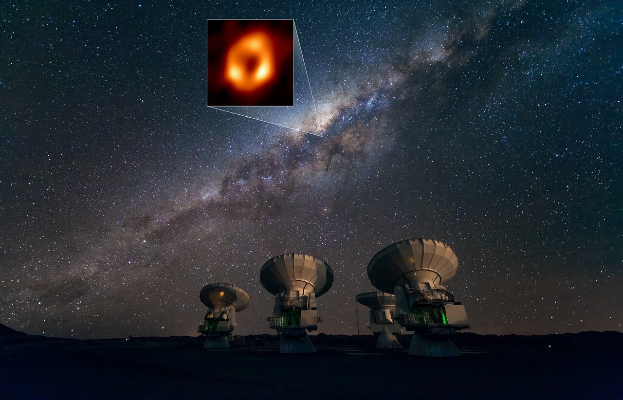
At the center of our Milky Way galaxy, there may not be a supermassive black hole, but rather a huge cluster of mysterious dark matter that exerts the same gravitational pull. This is according to the results of a study published in the journal Monthly Notices of the Royal Astronomical Society.
Mystery of Sagittarius A*
At the center of our galaxy is a compact radio source known as Sagittarius A*. Its mass is 4.3 million times greater than that of the Sun, and it is surrounded by a group of stars (known as S-stars) that move at tremendous speeds of several thousand kilometers per second.
Image of the shadow of Sagittarius A*. Source: EHT Collaboration
According to most researchers, Sagittarius A* is a supermassive black hole. In 2022, the Event Horizon Telescope (EHT) collaboration even managed to obtain an image of its shadow, consistent with theoretical predictions.
However, not everyone agrees with this interpretation. An international group of researchers has put forward an alternative idea, according to which Sagittarius A* is actually a cluster of dark matter — a mysterious substance that does not participate in electromagnetic interactions and manifests its existence through gravitational effects on other bodies.
Alternative hypothesis
According to a new hypothesis, Sagittarius A* consists of a certain type of light subatomic particles called fermions. It has a superdense compact core surrounded by an extensive diffuse halo, which together act as a single entity.
Artistic representation of the Milky Way, with a dark matter core at its center instead of a black hole. Source: Valentina Crespi et al.
According to scientists, the inner core of dark matter is so compact and massive that it can mimic the gravitational pull of a black hole and explain the orbits of S-stars, as well as the orbits of dust-enveloped objects known as G-sources, which also exist nearby.
The data from the Gaia mission, which mapped the rotation curve of the outer halo of the Milky Way, showing how stars and gas rotate away from the center, are particularly important for this hypothesis. A slowdown in the rotation curve of our galaxy, known as Keplerian decline, has been observed, which, according to researchers, can be explained by an external halo of dark matter combined with the Milky Way’s disk and bulge, which consist of ordinary matter.
“This is the first time a dark matter model has successfully bridged these vastly different scales and various object orbits, including modern rotation curve and central stars data,” said study co-author Dr. Carlos Argüelles of the La Plata Institute of Astrophysics.
“We are not just replacing the black hole with a dark object; we are proposing that the supermassive central object and the galaxy’s dark matter halo are two manifestations of the same, continuous substance.”
Shadow of Sagittarius A*
It is important to note that the fermion model of dark matter has already undergone rigorous testing. Previous research has shown that a dense core of dark matter would strongly bend light, creating a central darkness surrounded by a bright ring. This way, its image will match the famous image of the shadow of Sagittarius A* obtained by the EHT.
Location of Sagittarius A* in the sky. S7Source: ESO/José Francisco Salgado (josefrancisco.org), EHT Collaboration
The researchers also statistically compared their fermionic dark matter model with the traditional black hole model. They found that although current data on internal stars does not yet allow these two scenarios to be clearly distinguished, the dark matter model provides a unified framework that explains both the center of the galaxy (central stars and shadow) and the galaxy as a whole.
According to the authors, more accurate data obtained using instruments such as the GRAVITY interferometer on the Very Large Telescope in Chile, as well as the search for the unique signature of photon rings — a key feature of black holes that is absent in the dark matter core scenario — will be crucial for testing the predictions of their model.
The idea of having children in space sounds like something out of science fiction. However, scientists argue that the issue of protecting the reproductive health of astronauts is not futuristic, but a pressing reality, without which it is impossible to seriously talk about long-term missions to the Moon or Mars, or even further into the Solar System.
The future of humanity depends on protecting the reproductive system from the harmful effects of space. Illustration generated by Copilot AI
The human body evolved on Earth, so the space environment is hostile to our biology. The two biggest threats are cosmic radiation and microgravity. Radiation can damage the DNA of reproductive cells and increase the risk of cancer, while the absence of gravity disrupts hormonal balance and affects embryo development.
Added to this are toxic dust from other planets, limited resources, stress factors, and disruption of circadian rhythms. In the long term, this poses a risk of cumulative damage to the reproductive system and even epigenetic changes that could affect the health of future generations.
What do we know, and what is unknown?
Scientists currently have too little data to draw definitive conclusions. Only limited animal studies exist. Information from astronauts who have been on long missions is insufficient. It is unknown how exactly prolonged stays outside Earth affect male fertility and female reproductive health.
That is why a group of experts led by clinical embryologist Giles Palmer is calling for a comprehensive research program to be launched immediately. “It is very important to prepare for fertility risks as interest in lunar missions and Mars exploration grows,” explains the scientist.
Towards a secure future
Future research should focus on understanding the impact of space factors on each stage of the reproductive process. This will enable the development of effective protective measures, ranging from special radiation shields to fertility preservation methods and medical countermeasures.
Advanced reproductive technologies, particularly those utilizing artificial intelligence and automation adapted for use in space, will play a key role.
It’s time to act now
Science does not plan to send pregnant women into space for experiments. Research will be conducted on Earth under simulated conditions. However, it is already necessary to establish international ethical principles to regulate this area. The priorities should be informed consent, transparency, gender equality, and absolute protection of the health of future generations. This is not only a matter of science, but also of responsibility for the future of humanity beyond our planet.
Reproduction in space remains a distant prospect, but planning has to start today. Overcoming reproductive challenges is no less important for colonizing the solar system than developing powerful rockets or life support systems. The future of space civilization depends on how we now move to protect what is most precious — human life in all its potential for continuation.
One of Earth’s deepest secrets has come to light in new University of Liverpool research that identifies how two vast, hot rock structures in the planet’s mantle produce unusual magnetic activity, shaping the planet over hundreds of millions of years.
What lies in the deepest regions beneath the Earth’s surface is fairly well understood, although humans have only directly observed it at a depth of 12 kilometers. Now, researchers have uncovered new evidence about the magnetic influence of two unusual structures where the Earth’s mantle touches the core, as revealed in a recent paper published in Nature Geoscience.
A Mysterious Boundary
A lack of direct access to Earth’s interior leaves room for uncertainty, as well as new discoveries. One such discovery was made recently when University of Liverpool researchers identified two continent-sized rock structures about 2,900 kilometers below Earth’s surface, located beneath Africa and the Pacific Ocean, that influence the planet’s magnetic field. These ultra-hot regions affect the planet’s molten outer core, altering how the magnetic field is generated locally.
According to the new study from the DEEP (Determining Earth Evolution using Palaeomagnetism) research group in the University of Liverpool’s School of Environmental Sciences, working with researchers from the University of Leeds, the rock forming these structures remains solid despite being superheated and is surrounded by a ring of cooler rock that stretches between the poles.
Investigating the Mantle
Similar to how a wind turbine generates electricity, the flow of liquid iron in Earth’s outer core produces the planet’s magnetic field. Inside Earth, the mantle acts as a cold sink for the geodynamo, creating cooler pockets. Although the mantle is relatively uniform seismically, researchers expect significant lateral variations in heat distribution, which could influence how the iron core flows. The DEEP team sought to use paleomagnetic data to better understand this region—a challenging task.
Previous work in this area assumed uniformity or examined relatively short time scales. In this study, the team combined magnetic data with a mathematical model of the geodynamo to investigate its activity over the last 265 million years. Collecting measurements of these magnetic fields and running simulations of the processes that generate them posed major technical challenges.
From the models, the team reconstructed 265 million years of magnetic field activity. The complexity and duration of these simulations pushed the limits of the supercomputers available to the researchers.
Mantle Structures Discovered
The simulations revealed an irregular upper boundary of the outer core. The immense rock structures capped the molten hot spots. Intriguingly, some areas of the magnetic field proved more volatile than others, either changing significantly or remaining relatively stable for hundreds of millions of years.
“These findings suggest that there are strong temperature contrasts in the rocky mantle just above the core and that, beneath the hotter regions, the liquid iron in the core may stagnate rather than participate in the vigorous flow seen beneath the cooler regions,” said lead author Andy Biggin, Professor of Geomagnetism at the University of Liverpool. “Gaining such insights into the deep Earth on very long timescales strengthens the case for using records of the ancient magnetic field to understand both the dynamic evolution of the deep Earth and its more stable properties.”
“These findings also have important implications for questions surrounding ancient continental configurations—such as the formation and breakup of Pangaea—and may help resolve long-standing uncertainties in ancient climate, palaeobiology, and the formation of natural resources,” Biggin added.
Overall, the team’s work challenges the assumption that the Earth’s magnetic field behaves like a stable bar magnet over long periods. From this new conceptual starting point, the team hopes that going forward, their findings will help the ancient processes that forged our modern planet come into clearer view.
Ryan Whalen covers science and technology for The Debrief. He holds an MA in History and a Master of Library and Information Science with a certificate in Data Science. He can be contacted at ryan@thedebrief.org, and follow him on Twitter @mdntwvlf.
The enormous gravity of a black hole would explain the orbits of so–called S–stars, which spin around the core at speeds of a few thousand kilometres per second.
Meanwhile, the gentle tug from the cloud of dark matter is said to explain why our galaxy's rotation doesn't slow down dramatically towards the outer rim.
Now, scientists from the Institute of Astrophysics La Plata have put forward an alternative theory.
They suggest our galaxy might actually rotate around an enormous clump of mysterious dark matter.
According to the experts, a super–dense clump of dark matter would explain both the violent dance of stars near the galactic core and our galaxy's gentle rotation.
There might be black hole at the centre of our galaxy, but rather an enormous clump of mysterious dark matter (artistic impression), according to scientists
The conventional theory is a supermassive black hole named Sagittarius A* (artist's impression) at the centre of the Milky Way is responsible for the galaxies rotation, but scientists now say dark matter could produce the same effects
Study co–author Dr Carlos Argüelles, of the Institute of Astrophysics La Plata, says: 'We are not just replacing the black hole with a dark object; we are proposing that the supermassive central object and the galaxy's dark matter halo are two manifestations of the same, continuous substance.'
The key to this surprising suggestion lies in a very specific form of dark matter composed of particles called fermions, which are extremely light subatomic particles
In theory, these particles could form a super–dense, compact core, surrounded by a diffuse halo that would act as a single, unified entity.
The dense core would explain the fast movement of the S–stars, while the outer halo could explain the broader movements of the galaxy on the grandest scale.
'This is the first time a dark matter model has successfully bridged these vastly different scales and various object orbits,' says Dr Argüelles.
Crucially, this theory can also explain one of the most important observations we have of the Milky Way's inner core.
In 2022, scientists from the Event Horizon Telescope Collaboration used an Earth–spanning network of telescopes to take the first image of the galactic core.
The researchers say that their theory is compatible with the image of the galactic centre which is believed to show the supermassive black hole Sagittarius A*
Any theory that suggests there is something other than a black hole at the centre of the galaxy needs to explain how this picture might have come about.
Luckily, a recent study conducted by Dr Argüelles and another group of collaborators found that the light generated by matter swirling around a dense clump of dark matter produces an image strikingly like the Event Horizon Telescope image.
Lead author Valentina Crespi, a PhD student at the Institute of Astrophysics La Plata, says: 'Our model not only explains the orbits of stars and the galaxy's rotation but is also consistent with the famous 'black hole shadow' image.
'The dense dark matter core can mimic the shadow because it bends light so strongly, creating a central darkness surrounded by a bright ring.'
According to the researchers, our current observations of stars surrounding the galactic core are equally compatible with the black hole and fermion dark matter models.
However, they argue that the dark matter theory is preferable because it explains the structure and behaviour of the Milky Way with a single unified object.
In the future, more precise observations will be necessary to determine with certainty what lies at the heart of the galaxy.
For example, extremely sensitive instruments might be able to detect the signature of 'photon rings' – a tell–tale sign of black holes that would be absent in the dark matter scenario.
The galactic centre of the Milky Way is dominated by one resident, the supermassive black hole known as Sagittarius A*.
Supermassive black holes are incredibly dense areas in the centre of galaxies with masses that can be billions of times that of the sun.
They act as intense sources of gravity which hoover up dust and gas around them.
Evidence of a black hole at the centre of our galaxy was first presented by physicist Karl Jansky in 1931, when he discovered radio waves coming from the region.
Pre-eminent yet invisible, Sgr A* has the mass equivalent to some four million suns.
At just 26,000 light years from Earth, Sgr A* is one of very few black holes in the universe where we can actually witness the flow of matter nearby.
Less than one per cent of the material initially within the black hole’s gravitational influence reaches the event horizon, or point of no return, because much of it is ejected.
Consequently, the X-ray emission from material near Sgr A* is remarkably faint, like that of most of the giant black holes in galaxies in the nearby universe.
The captured material needs to lose heat and angular momentum before being able to plunge into the black hole. The ejection of matter allows this loss to occur.
Is it possible tosave Earth from a deadly asteroid by blowing it up, as in Hollywood blockbusters? Earlier calculations showed that such a scenario would lead to the formation of debris that would only exacerbate the impending catastrophe. But a revolutionary new simulation conducted by an international team of scientists provides an unexpected answer: yes, a nuclear explosion could be a viable plan, and even better than we thought. The scientists described this optimistic future in a publication in Nature Communications.
A nuclear strike near the asteroid proved to be a more successful solution than a kinetic collision with it. Illustration generated by Grok AI
The key discovery is that space bodies are much more resistant to extreme impact loads than laboratory tests have shown. This is good news for planetary defense. If a nuclear strike is directed at an asteroid, it will most likely remain intact rather than disintegrate into a deadly shower of thousands of fragments that will still fall on the planet.
How to test a meteorite without destroying it
Researchers from Oxford University and Outer Solar System (OuSoCo) have solved a fundamental problem: the inability to observe the reaction of asteroid material in real time under impact. They used a particle accelerator at CERN to irradiate a sample of the Campo del Cielo iron meteorite with high-energy protons.
An experimental setup in which a laser was used to irradiate a cylindrical sample cut from a meteorite. Credit: Bochmann et al., Nat. Commun.
“This is the first time we have been able to safely observe, in real time, how a real meteorite sample deforms and adapts in extreme conditions without being destroyed,” explains physicist Gianluca Gregori.
The sensors recorded surprising dynamics. Under the influence of a powerful impulse, the meteorite first softened and bent, and then — unexpectedly — hardened again. It also demonstrated the ability to dissipate impact energy more effectively than the stronger the impact itself. This explains why previous estimates of asteroid strength were incorrect.
Consequences for planetary defense
This research is critical for choosing a strategy. Missions such as DART, which deflect asteroids with a kinetic impact, are effective but require high precision. The nuclear option, as simulations have shown, may be safer.
“The world must be able to execute a nuclear deflection mission with high confidence, yet cannot conduct a real-world test in advance. This places extraordinary demands on material and physics data,” notes Karl-Georg Schlesinger of OuSoCo.
In real life, it’s not like in the movies
In reality, no one is planning to drill into an asteroid and place a bomb inside it. Physicists are proposing a different scenario: conducting a nuclear explosion at a certain distance from the celestial body. The mass vaporized by radiation will create a reactive thrust that will gradually change the asteroid’s orbit, directing it away from Earth.
Thus, humanity’s last argument in the fight against cosmic threats is scientifically justified. Fortunately, in reality, it will not be as dramatic, but much more reliable than in the movies.
A supermassive black hole with a case of 'cosmic indigestion' has been burping out the remains of a shredded star for four years, experts have discovered.
Astronomers say the radio wave jet shooting out of the black hole is a contender for one of the brightest, most energetic things ever detected in the universe.
Calculations suggest the current energy outflow is up to 100 trillion times that of the infamous super–powerful Death Star, from the Star Wars universe.
Astrophysicists have documented plenty of incidents where a star gets too close to a black hole and is shredded by its gravitational field.
But a black hole emitting this much energy so many years after chewing up a star is unprecedented.
The team even predict the stream of radio waves belching from the cosmic entity will keep increasing exponentially before peaking next year.
'This is really unusual', said Yvette Cendes, an astrophysicist at the University of Oregon, who led the work.
'I'd be hard–pressed to think of anything rising like this over such a long period of time.'
An artistic representation of the tidal disruption event, or a black hole shredding a star in a process known as 'spaghettification'
Calculations suggest the current energy outflow is up to 100 trillion times that of the infamous super–powerful Death Star, from the Star Wars universe
The process began in 2018, when a small star was ripped to shreds when it wandered too close to a black hole in a galaxy located 665 million light years from Earth.
The 'tidal disruption event' (TDE) did not come as a surprise to astronomers, who occasionally witness these violent incidents while scanning the night sky.
In this case, the gravitational tug of the black hole shredded the nearby star in a process called 'spaghettification'.
This is the extreme vertical stretching and horizontal compression of objects into long, thin shapes.
But nearly three years after the massacre the black hole began lighting up the skies, emitting large amounts of energy in the form of radio waves.
In the latest paper, Dr Cendes and her colleagues show that the energy emitted from the black hole has continued to rise sharply over the last few years – and it is now 50 times brighter than it was when originally detected.
The celestial event is officially called AT2018hyz, but the team prefer the nickname 'Jetty McJetface'.
They calculated the current energy outflow of the black hole and came up with an astounding number, putting it on a par with a gamma ray burst and potentially placing it among the most powerful single events ever detected in the universe.
The scientists found that energy outflow has increased exponentially over the last few years, as shown by this graph
Death Star, the fictional, moon–sized superweapon and space station from Star Wars, is capable of destroying planets with its kyber crystal–powered laser
What is spaghettification?
In astrophysics, spaghettification is the tidal effect caused by strong gravitational fields.
When falling towards a black hole, for example, an object is stretched in the direction of the black hole (and compressed perpendicular to it as it falls).
In effect, the object can be distorted into a long, thin version of its undistorted shape, as though being stretched like spaghetti.
To put it in sci fi terms, they worked out that the black hole is emitting at least a trillion – possibly closer to 100 trillion – times the amount of energy the Death Star would emit.
This fictional, moon–sized superweapon and space station from Star Wars is capable of destroying planets with its kyber crystal–powered laser.
The team plan to continue to track the object to see how it continues to behave in the coming years.
Back in 2022, when the team first announced something unusual was happening, co–author Edo Berger, professor of astronomy at Harvard University, said: 'We have been studying TDEs with radio telescopes for more than a decade.
'We sometimes find they shine in radio waves as they spew out material while the star is first being consumed by the black hole.
'But in AT2018hyz there was radio silence for the first three years, and now it's dramatically lit up to become one of the most radio luminous TDEs ever observed.'
Astronomers often describe black holes as 'messy eaters', as some material occasionally gets flung back out into space.
But the emission this creates, known as an outflow, normally develops quickly.
Dr Cendes at the Very Large Array, a large radio telescope facility in New Mexico that detected the phenomenon
'It's as if this black hole started abruptly burping out a bunch of material from the star it ate years ago,' Dr Cendes said.
'This caught us completely by surprise — no one has ever seen anything like this before.'
Black holes are so dense and their gravitational pull is so strong that no form of radiation can escape them - not even light.
They act as intense sources of gravity which hoover up dust and gas around them. Their intense gravitational pull is thought to be what stars in galaxies orbit around.
How they are formed is still poorly understood. Astronomers believe they may form when a large cloud of gas up to 100,000 times bigger than the sun, collapses into a black hole.
Many of these black hole seeds then merge to form much larger supermassive black holes, which are found at the centre of every known massive galaxy.
Alternatively, a supermassive black hole seed could come from a giant star, about 100 times the sun's mass, that ultimately forms into a black hole after it runs out of fuel and collapses.
When these giant stars die, they also go 'supernova', a huge explosion that expels the matter from the outer layers of the star into deep space.
Space junk disaster spirals after Russian satellite shatters in orbit
Space junk disaster spirals after Russian satellite shatters in orbit
Story by Cassian Holt
Space junk disaster spirals after Russian satellite shatters in orbit
When a Russian satellite shattered in orbit, the fragments did not simply drift away into the void. They spread into busy traffic lanes of low Earth orbit, forcing astronauts to scramble for shelter and tracking networks to light up with new warnings. The incident turned a long‑running concern about space junk into an immediate operational crisis, underscoring how fragile the infrastructure above our heads has become.
The breakups of multiple Russian spacecraft, from imaging platforms to a high‑profile spy satellite, now form a chain of events that looks less like bad luck and more like a systemic failure to manage aging hardware. I see in this pattern a preview of a more chaotic orbital environment, where every uncontrolled explosion or collision multiplies the risk for the International Space Station, commercial constellations, and future missions.
The Russian satellite that triggered an orbital scare
The most visible shock came when a decommissioned Russian satellite suddenly fragmented, sending a cloud of debris across the paths of crewed spacecraft. U.S. tracking networks reported that the Russian spacecraft broke apart into at least 100 trackable fragments, a number that only counts objects large enough for ground radars to see. Earlier coverage of the same event described nearly 200 pieces, a reminder that the true population of shards, including those too small to track but still lethal at orbital speeds, is almost certainly higher. For the crew of the International Space Station, the numbers were not abstract: astronauts were ordered to shelter in their return vehicle as the swarm passed through their neighborhood.
Behind those radar plots sits a formal military apparatus that now treats orbital debris as a strategic concern. U.S. Space Command oversees a global network of sensors that catalog tens of thousands of objects, and it was this system that first confirmed the Russian breakup and began issuing conjunction warnings. In public statements, the same command has stressed that the debris field came from a Russian‑owned object and that analysts are still working to understand the cause, a point echoed in a separate press release from PETERSON AIR FORCE BASE, Colo that identified the spacecraft as RESURS‑P1 and Russia as the satellite owner. That combination of operational urgency and diplomatic sensitivity is now standard whenever a major spacefaring nation loses control of hardware in orbit.
The RESURS‑P1 episode over the summer showed how even retired satellites can come back to haunt the orbital ecosystem. The imaging platform, known in Russian sources as Resurs, had been removed from service after exceeding its primary mission by 3.5 years, according to Russian outlet TASS, but it remained in a relatively crowded orbit. When it finally broke apart, U.S. Space Debris tracking indicated that fragments from the Russian Satellite Breakup Forces ISS Astronauts to Take Cover, prompting controllers to move the station into a safer orientation and direct the crew to close hatches. The cause of the RESURS‑P1 breakup remains unclear, but the operational impact was unmistakable.
On the ground, Mission Control teams worked through the night to refine trajectories and assess whether any fragments posed an immediate collision threat. Space Command officials emphasized on Thursday that they observed no immediate danger to the ISS or other spacecraft, even as they acknowledged that the cloud would need to be monitored for years as it slowly dispersed and decayed. For me, that is the most sobering part of the story: a single failure of an aging Russian satellite can create a long‑lived hazard that forces every other operator, from weather agencies to broadband providers, to spend fuel and attention dodging fragments they did not create.
From inspector to wreckage: the Luch / Olymp disaster
The Russian reconnaissance satellite Luch, also known as Olymp, illustrates how the debris problem is no longer confined to low Earth orbit. The Russian spacecraft, identified in tracking catalogs as NORAD 40258, operated in a so‑called graveyard orbit where retired satellites are supposed to pose less risk to active constellations. Yet The Russian Luch, or Olymp, was reported to be completely destroyed after a collision with space debris while still tasked with reconnaissance and signal interception. That outcome turns the very concept of a safe graveyard orbit on its head, showing that even regions set aside for retired hardware are now contaminated by high‑speed shrapnel.
Analysts have tied the Luch incident to a broader pattern of Russian satellites suffering catastrophic failures in under‑monitored orbital regimes. A detailed assessment titled Russian Spy Satellite by Suspected Debris Strike in Graveyard Orbit, By SOFX, argues that the destruction of the platform highlights the contested character of space operations, even in orbits once considered quiet backwaters. A companion report, credited to Feb, SWJ, Staff, notes that The Soyuz MS spacecraft docked to the ISS (Photo Courtesy NASA) was part of the broader context in which Russian assets are increasingly entangled with debris fields. I read these accounts as a warning that the line between active and retired orbits is blurring, and that operators can no longer assume that moving a satellite higher is enough to guarantee safety.
A Russian ‘inspector’ satellite and the mystery of silent breakups
Not all debris‑creating events are as dramatic as a collision in graveyard orbit. In Jan, observers noticed that a Russian spacecraft described as an “inspector” satellite had quietly begun to shed pieces, with no obvious trigger such as a launch failure or anti‑satellite test. Ground‑based observations suggested the Russian vehicle was breaking apart in orbit, raising debris concerns among analysts who track unusual maneuvers and proximity operations. The fact that this satellite was designed to approach and inspect other spacecraft only heightens the unease, since any uncontrolled fragments from such a platform could threaten the very assets it was meant to observe.
From my perspective, the most troubling aspect of the inspector breakup is how little is publicly known about its cause or the exact number of fragments. A follow‑on analysis of the same Jan event, based on Ground observations, underscored that the satellite’s behavior deviated from its previous pattern without any official explanation from Moscow. In an environment where even small fragments can puncture a pressure hull or shred solar arrays, that opacity is not just a diplomatic problem, it is a direct operational risk for every operator sharing the same orbital band.
Tracking the fragments and the race to contain the crisis
As Russian satellites continue to fail in ways that generate debris, the burden of tracking and mitigating the fallout increasingly falls on a mix of military and commercial networks. U.S. Space Command remains the backbone of global surveillance, but it is now joined by private firms that specialize in high‑fidelity mapping of orbital traffic. One of the most prominent, LeoLabs, operates phased‑array radars that can detect small debris in low Earth orbit and provide conjunction warnings to satellite operators who lack their own tracking infrastructure. In the wake of the Russian breakups, such services have become essential for companies flying large constellations of small satellites, which are particularly vulnerable to untracked fragments.
At the same time, scientific and policy communities are sounding louder alarms about the cumulative effect of these incidents. A detailed overview titled Russian Satellite Explosion frames the Luch / Olymp disaster as part of a broader trend in which Space Debris Is Growing Out of Control, and highlights The Rise of Space Debris and How The Luch, Olymp event illustrates the feedback loop between collisions and new fragments. Broadcast coverage has reinforced that message for a wider audience, with one Jun segment noting that a Russian satellite had broken up into more than 100 pieces of debris in orbit, forcing astronauts on the International Space Station, sometimes referred to as the International Space, to take shelter. For me, the throughline is clear: without stricter end‑of‑life rules, active debris removal, and more transparency from operators like Russia, each new breakup will not be an isolated mishap but another turn in a spiraling crisis that affects every nation and every mission that depends on the space above Earth.
Dutch researchers have found evidence of approximately 20 mysterious, large-scale structures hidden beneath the sediment of an ancient lost ocean on Mars. The team also reports the discovery of evidence that an active Martian crust is pushing against Olympus Mons, elevating the solar system’s largest volcano.
These formations are hidden beneath thick, smooth sediment layers thought to be remnants of an ancient seabed.
(CREDIT: NASA/MOLA Science Team/O. de Goursac, Adrian Lark)
Previous scientific efforts have found hidden ice deposits and other unexpected structures on the red planet. However, the researchers behind this latest discovery say these mysterious, large-scale structures are particularly perplexing because they appear hidden beneath the sedimentary layers of an ancient ‘lost’ Martian ocean.
“These dense structures could be volcanic in origin or could be compacted material due to ancient impacts,” explained Dr. Bart Root of Delft University of Technology (TU Delft), who presented the team’s findings at the Europlanet Science Congress (EPSC) in Berlin. “There are around 20 features of varying sizes that we have identified dotted around the area surrounding the north polar cap – one of which resembles the shape of a dog.”
Map highlighting the dense gravitational structures in the northern hemisphere. The regions denoted by the black lines are high mass anomalies that do not show any correlation with geology and topography. These hidden subsurface structures are covered by sediments from an old ocean. Their origin is still a mystery and a dedicated gravity mission, like MaQuIs, is needed to reveal their nature.
(CREDIT: Root et al.)
“There seems to be no trace of them at the surface,” the researcher added. “However, through gravity data, we have a tantalizing glimpse into the older history of the northern hemisphere of Mars.”
Mysterious, Large-Scale Structures Revealed by Gravity Map
Dr. Root and colleagues from Utrecht University initially set out to use tiny variations in the orbits of Martian satellites caused by gravitational differences of varying materials within the planet’s crust to make a gravitational map. This data was added to computer models containing data collected by NASA’s Mars Insight mission on the Martian crust’s flexibility and thickness. Combined with data on the dynamics of Mars’ mantle and the planet’s deep interior, the team successfully created a global density map of the entire planet.
When examining their newly created gravity map, the team noticed a group of mysterious structures in the planet’s northern polar regions. According to the researchers, these large-scale mysterious structures are approximately 300-400 kg/m3 denser than their surroundings. The structures are not visible from the surface but instead appear to have been buried in the planet’s ancient past beneath the remnants of a large ocean.
Gravity map of Mars. The red circles show prominent volcanoes on Mars, and the black circles show impact crates with a diameter more significant than a few 100 km. A ‘gravity high’ signal is located in the volcanic Tharsis Region (the red area in the center-right of the image), surrounded by a ring of negative gravity anomaly (shown in blue). Image Credit: Root et al.
Another mystery revealed by the team’s gravity map involved large structures underneath the huge volcanic region of Tharsis Rise. Known for its preponderance of volcanoes, the area is also home to the solar system’s largest volcano, Olympus Mons
“Although volcanoes are very dense, the Tharsis area is much higher than the average surface of Mars and is ringed by a region of comparatively weak gravity,” according to a statement announcing the study. “This gravity anomaly is hard to explain by looking at differences in the Martian crust and upper mantle alone.”
This colorized image of the surface of Mars was taken by the Mars Reconnaissance Orbiter. The line of three volcanoes is the Tharsis Montes, with Olympus Mons to the northwest. Valles Marineris is to the east.
(NASA/JPL-Caltech/Arizona State University)
According to the researchers, a “light mass” of around 1750 kilometers across and at a depth of 1100 kilometers appears to be actively pushing up on the entire Tharsis region. They suspect this light mass could be a massive plume of lava hidden deep within the Marin interior that is slowly working toward the surface. Root says this information may show that Mars is still active beneath the planet’s outer surface.
An image of Olympus Mons, the solar system’s largest volcano, captured by the European Space Agency’s (ESA) Mars Express Mission. The latest study found evidence that an underground lava plume may be pushing up on the entire area around the volcano.
Photo by ESA/DLR/FUBerlin/AndreaLuck – Olympus Mons – ESA Mars Express, CC BY 2.0, https://commons.wikimedia.org/w/index.php?curid=130092547
Comparative image showing the height differences between Earth's largest mountains and Olympus Mons.
(CREDIT: CC BY-SA 3.0)
“The NASA InSight mission has given us vital new information about the hard outer layer of Mars,” he explained. “This means we need to rethink how we understand the support for the Olympus Mons volcano and its surroundings.”
Mars Quantum Gravity Mission Could Solve the Mystery
Next, Root has joined a team proposing a Mars Quantum Gravity (MaQuis) mission. In that proposal, the team says that an ideal mission would include similar technology to that used by the GRAIL and GRACE missions, which were designed to map the Moon’s and Earth’s gravity, respectively. The mission could also help the team solve the true nature of the mysterious, large-scale structures hidden beneath the Martian surface.
“Observations with MaQuIs would enable us to better explore the subsurface of Mars,” said Dr. Lisa Wörner of DLR, who presented on the MaQuIs mission at EPSC2024. “This would help us to find out more about these mysterious hidden features and study ongoing mantle convection, as well as understand dynamic surface processes like atmospheric seasonal changes and the detection of ground water reservoirs.”
Christopher Plain is a Science Fiction and Fantasy novelist and Head Science Writer at The Debrief. Follow and connect with him on X, learn about his books at plainfiction.com, or email him directly at christopher@thedebrief.org.
Composite images of Mars taken by the Hubble Space Telescope in 2024. Thin clouds of water ice, visible in ultraviolet light, give the red planet an icy appearance. The frigid north polar ice cap was experiencing the beginning of Martian spring. Credit: NASA, ESA, STScI
The current image of Mars as an arid and hostile desert contrasts sharply with the history revealed by its surface. Channels, minerals altered by water, and other geological traces indicate that the red planet was, in its early days, a much wetter and more dynamic world. Reconstructing how this water-rich environment disappeared remains one of the great challenges of planetary science. Although several processes are known that can explain some of this loss, the fate of much of Martian water remains a mystery.
A new study from an international team of researchers published in Communications Earth & Environment on February 2, 2026, has brought us a significant step closer to solving this puzzle. For the first time, researchers demonstrated that an anomalous, intense, but localized dust storm was able to drive the transport of water to the upper layers of the Martian atmosphere during the Northern Hemisphere summer—a time when this process was previously considered to be irrelevant.
Diagram illustrating the atmospheric response to a localized dust storm in the Northern Hemisphere during the local summer season. High dust concentrations significantly increase the absorption of solar radiation, leading to greater atmospheric warming, especially in the middle atmosphere. Furthermore, the increased atmospheric circulation associated with the dust storm enhances the vertical transport of water vapor from the lower atmosphere, promoting water injection at higher altitudes and increasing hydrogen escape from the exobase.
"The findings reveal the impact of this type of storm on the planet's climate evolution and opens a new path for understanding how Mars lost much of its water over time," says Adrián Brines, a researcher at the Instituto de Astrofísica de Andalucía (IAA-CSIC) and co-lead author of the study along with Shohei Aoki, a researcher from the Graduate School of Frontier Sciences at the University of Tokyo and the Graduate School of Science at Tohoku University.
While dust storms have long been recognized as important for Mars's water escape, previous discussions have mostly focused on large, planet-wide dust events. In contrast, this study shows that smaller, regional storms can also strongly enhance water transport to high altitudes, where it can be more easily lost to space. Furthermore, previous research has focused on the warm, dynamic summers of the Southern Hemisphere, since it is typically the main period of water loss on Mars.
Daily MRO-MARCI global map images of the initial growth of a rare regional dust storm in northwestern Syrtis Major, observed on August 21, 2023, at Ls = 107.6° (left) and August 22, 2023, at Ls = 108.0° (right), reaching an extent of 1.2 × 10⁶ km².
This study detected an unusual increase in water vapor in the middle atmosphere of Mars during the Northern Hemisphere summer in Martian year 37 (2022–2023 on Earth), caused by an anomalous dust storm. At these altitudes, the amount of water was up to 10 times greater than usual, a phenomenon not observed in previous Martian years and not predicted by current climate models.
Shortly afterward, the amount of hydrogen in the exobase—the region where the atmosphere merges with space—increased significantly to 2.5 times that of the previous years during the same season. One of the keys to understanding how much water Mars has lost is measuring how much hydrogen has escaped into space, since this element is readily released when water breaks down in the atmosphere.
"These results add a vital new piece to the incomplete puzzle of how Mars has been losing its water over billions of years, and show that short but intense episodes can play a relevant role in the climate evolution of the red planet," concludes Aoki.
Image of the Black Beauty meteorite. Credit - NASA
New tools unlock new discoveries in science. So when a new type of non-destructive technology becomes widely available, it's inevitable that planetary scientists will get their hands on it to test it on some meteorites. A new paper, available in pre-print on arXiv, by Estrid Naver of the Technical University of Denmark and her co-authors, describes the use of two of those (relatively) new tools to one of the most famous meteorites in the world - NWA 7034 - also known as Black Beauty.
Part of Black Beauty’s fame comes from its origin. It’s a piece of Mars that fell to Earth, most likely after a huge impact on the Red Planet. It's made up of material from around 4.48 billion years ago, making it some of the oldest known Martian material in the solar system. Not to mention it’s strikingly beautiful - hence its name.
Unfortunately, previous studies have required scientists to cut off parts of this masterpiece in order to study them. These parts are then either crushed or dissolved to unlock the materials the rock is made up of. But we can do better than that now - with the advent of computed tomography (CT) machines.
https://www.youtube.com/shorts/nPJdZvHFuow Video of the CT scan of the Black Beauty meteorite. Credit - rebekahhines4431 YouTube Channel
There are two types of CT scanners. One, which is commonly used in doctor’s offices throughout the world, is X-ray CTs. These are exceptionally good at finding heavy, dense materials like iron or titanium. Another, less commonly used method, is Neutron CT, which uses neutrons instead of X-rays to pass through its object of study. The results from this scan vary widely, but it generally is better at penetrating denser materials, and, importantly, finding hydrogen - one of the key components of water.
In the paper, the researchers use both these techniques to non-destructively test Black Beauty and see what it held. While non-destructive, they did, admittedly, use only a small sample of the meteorite, which had been previously polished. But when they looked at their small sample material, they found “clasts”.
In geology terms, a clast is just a word for a small rock fragment stuck inside a bigger rock. Finding clasts isn’t surprising - scientists have known that Black Beauty was composed of them for decades, which makes sense given that we knew the origin of the meteorite was a Martian impact that fused rocks together. But the particular kinds of clasts that the CTs found were new.
Fraser discusses where liquid water could be hiding on Mars.
Known as “Hydrogen-rich Iron oxyhydroxide”, or H-Fe-ox, clasts, these hydrogen-rich clusters made up approximately 0.4% of the volume of the sample of Black Beauty they tested, which was about the size of a fingernail. While that might seem like a small amount, the chemical math of the internal of the meteorite means that those little bits of rock hold up to about 11% of the sample’s total water content.
Black Beauty itself has an estimated 6,000 parts-per-million (ppm) of water, which is extremely high coming from a planet with so little water on it currently. But, importantly, these findings complement the discovery of watery samples at Jezero crater by Perseverance. Despite Black Beauty coming from a completely different part of Mars than the rover samples, the link between the samples proves there was widespread, likely liquid water, on the surface of Mars billions of years ago.
This beautiful meteorite is in itself basically a sample return mission in a single rock. However, the scientists that analyzed it were hoping to use the same non-destructive CT techniques on future Mars Sample Return mission samples. CT scans can see right through the titanium housing the samples had been collected in. But, given the recent cancellation of that program, it might be a very long time before any such direct planetary samples are subjected to the powerful tools we have back here on Earth.
There is still a Chinese sample return mission planned, though, so perhaps it won’t be as long as expected. Until then, running the same sort of non-destructive test on other Martian meteorites seems a good use of the expertise and equipment. Hopefully we’ll see plenty more studies of other samples in the future.
The length of a night on Mars isn’t too different from here on Earth, lasting just over 12 hours on average. Thanks to its similar axial tilt, it also experiences longer nights in winter and shorter nights during summer — but the gloom is eerie, with temperatures plummeting to as low as -100 degrees Fahrenheit near its equator. And thanks to the complete lack of artificial light, the night sky will shimmer with the usual star constellations we’ve come to know back on Earth.
Technically, though, it’s not a complete blackout on the Red Planet’s surface at night. NASA’s Curiosity Mars rover, which has been wandering the planet’s deserted landscapes for almost 14 years, is outfitted with LED lights at the end of its robotic arm, allowing it to light up the seemingly endless darkness.
Case in point, a December 6 imagerecently featured by NASAshows the rover’s lights lighting up a hole it drilled into the surface of the rock, dubbed “Nevado Sajama.” It’s an eerie viewof an alien environment, a stark reminder that the lone rover has plenty of almost complete blackness to contend with as it probes Mars for signs of ancient life.
The camera, called the Mars Hand Lens Imager, is one of seventeen cameras attached to the rover, and can take true-color images at a resolution of 1,600 by 1,200 pixels. It features both UV and white LED lights, allowing it to take pictures at night.
The use of the rover’s lights isn’t just for show. Scientists used the LEDs to illuminate areas that are otherwise “deep in shadow during the day,” as NASA explains, “such as the insides of drill holes and the inlet tubes leading to instruments in the rover’s belly.”
The lights have previously been used to examine layering inside rocks to better understand their composition. However, Curiosity changed the way it drilled its holes in 2018 in light of some problems with its drill, making the new holes “too rough and dusty to see any such details” ever since.
However, a hole Curiosity drilled on November 13, its 4,740th Martian day (or sol) on the planet, was deemed “smooth enough to try looking for layers.”
The image, which was taken weeks later, allowed the team to better get a sense of the rock, which was found in a region dotted with “boxwork” geologic formations.
Beste bezoeker, Heb je zelf al ooit een vreemde waarneming gedaan, laat dit dan even weten via email aan Frederick Delaere opwww.ufomeldpunt.be. Deze onderzoekers behandelen jouw melding in volledige anonimiteit en met alle respect voor jouw privacy. Ze zijn kritisch, objectief maar open minded aangelegd en zullen jou steeds een verklaring geven voor jouw waarneming! DUS AARZEL NIET, ALS JE EEN ANTWOORD OP JOUW VRAGEN WENST, CONTACTEER FREDERICK. BIJ VOORBAAT DANK...
Druk op onderstaande knop om je bestand , jouw artikel naar mij te verzenden. INDIEN HET DE MOEITE WAARD IS, PLAATS IK HET OP DE BLOG ONDER DIVERSEN MET JOUW NAAM...
Druk op onderstaande knop om een berichtje achter te laten in mijn gastenboek
Alvast bedankt voor al jouw bezoekjes en jouw reacties. Nog een prettige dag verder!!!
Over mijzelf
Ik ben Pieter, en gebruik soms ook wel de schuilnaam Peter2011.
Ik ben een man en woon in Linter (België) en mijn beroep is Ik ben op rust..
Ik ben geboren op 18/10/1950 en ben nu dus 75 jaar jong.
Mijn hobby's zijn: Ufologie en andere esoterische onderwerpen.
Op deze blog vind je onder artikels, werk van mezelf. Mijn dank gaat ook naar André, Ingrid, Oliver, Paul, Vincent, Georges Filer en MUFON voor de bijdragen voor de verschillende categorieën...
Veel leesplezier en geef je mening over deze blog.


![located near Gruithuisen K crater. NAC controlled mosaic containing images M1173350480L/R, M1173357586L/R [NASA/GSFC/Arizona State University].](https://thedebrief.b-cdn.net/wp-content/uploads/2026/02/sinuous-lava-tubes-on-the-Moon.jpg)