The purpose of this blog is the creation of an open, international, independent and free forum, where every UFO-researcher can publish the results of his/her research. The languagues, used for this blog, are Dutch, English and French.You can find the articles of a collegue by selecting his category. Each author stays resposable for the continue of his articles. As blogmaster I have the right to refuse an addition or an article, when it attacks other collegues or UFO-groupes.
Druk op onderstaande knop om te reageren in mijn forum
Zoeken in blog
Deze blog is opgedragen aan mijn overleden echtgenote Lucienne.
In 2012 verloor ze haar moedige strijd tegen kanker!
In 2011 startte ik deze blog, omdat ik niet mocht stoppen met mijn UFO-onderzoek.
BEDANKT!!!
Een interessant adres?
UFO'S of UAP'S, ASTRONOMIE, RUIMTEVAART, ARCHEOLOGIE, OUDHEIDKUNDE, SF-SNUFJES EN ANDERE ESOTERISCHE WETENSCHAPPEN - DE ALLERLAATSTE NIEUWTJES
UFO's of UAP'S in België en de rest van de wereld Ontdek de Fascinerende Wereld van UFO's en UAP's: Jouw Bron voor Onthullende Informatie!
Ben jij ook gefascineerd door het onbekende? Wil je meer weten over UFO's en UAP's, niet alleen in België, maar over de hele wereld? Dan ben je op de juiste plek!
België: Het Kloppend Hart van UFO-onderzoek
In België is BUFON (Belgisch UFO-Netwerk) dé autoriteit op het gebied van UFO-onderzoek. Voor betrouwbare en objectieve informatie over deze intrigerende fenomenen, bezoek je zeker onze Facebook-pagina en deze blog. Maar dat is nog niet alles! Ontdek ook het Belgisch UFO-meldpunt en Caelestia, twee organisaties die diepgaand onderzoek verrichten, al zijn ze soms kritisch of sceptisch.
Nederland: Een Schat aan Informatie
Voor onze Nederlandse buren is er de schitterende website www.ufowijzer.nl, beheerd door Paul Harmans. Deze site biedt een schat aan informatie en artikelen die je niet wilt missen!
Internationaal: MUFON - De Wereldwijde Autoriteit
Neem ook een kijkje bij MUFON (Mutual UFO Network Inc.), een gerenommeerde Amerikaanse UFO-vereniging met afdelingen in de VS en wereldwijd. MUFON is toegewijd aan de wetenschappelijke en analytische studie van het UFO-fenomeen, en hun maandelijkse tijdschrift, The MUFON UFO-Journal, is een must-read voor elke UFO-enthousiasteling. Bezoek hun website op www.mufon.com voor meer informatie.
Samenwerking en Toekomstvisie
Sinds 1 februari 2020 is Pieter niet alleen ex-president van BUFON, maar ook de voormalige nationale directeur van MUFON in Vlaanderen en Nederland. Dit creëert een sterke samenwerking met de Franse MUFON Reseau MUFON/EUROP, wat ons in staat stelt om nog meer waardevolle inzichten te delen.
Let op: Nepprofielen en Nieuwe Groeperingen
Pas op voor een nieuwe groepering die zich ook BUFON noemt, maar geen enkele connectie heeft met onze gevestigde organisatie. Hoewel zij de naam geregistreerd hebben, kunnen ze het rijke verleden en de expertise van onze groep niet evenaren. We wensen hen veel succes, maar we blijven de autoriteit in UFO-onderzoek!
Blijf Op De Hoogte!
Wil jij de laatste nieuwtjes over UFO's, ruimtevaart, archeologie, en meer? Volg ons dan en duik samen met ons in de fascinerende wereld van het onbekende! Sluit je aan bij de gemeenschap van nieuwsgierige geesten die net als jij verlangen naar antwoorden en avonturen in de sterren!
Heb je vragen of wil je meer weten? Aarzel dan niet om contact met ons op te nemen! Samen ontrafelen we het mysterie van de lucht en daarbuiten.
11-03-2025
Space Force's X-37B is Back After 14 Secretive Months in Orbit
Space Force's X-37B is Back After 14 Secretive Months in Orbit
By Mark Thompson
The X-37B Space Plane
(Credit : NASA)
The X-37B is a reusable robotic space plane operated by the U.S. Space Force. It resembles a miniature space shuttle at just under 9 metres long with a 4.5 metre wingspan and is an uncrewed vehicle designed for long-duration missions in low Earth orbit. It launches vertically atop a rocket, lands horizontally like a conventional aircraft and serves as a testbed for new technologies and experiments that can be returned to Earth for analysis.
The U.S. Space Force's X-37B space plane is seen shortly after landing at NASA's Kennedy Space Center on Nov. 12, 2022, bringing an end to its OTV-6 mission.
(Image credit: Boeing/US Space Force)
It’s development was a collaborative effort between NASA, Boeing, and the U.S. Department of Defence. It was originally conceived by NASA in the late 1990s to explore reusable spaceplane technologies but transitioned to the U.S. Air Force in 2004 for military purposes.
Its mission profiles remain classified but the Space Force acknowledges that it conducts experiments related to advanced guidance systems, thermal protection materials, autonomous orbital operations, and various payloads for the Department of Defence and NASA. Since its first launch in 2010, the X-37B has now completed seven successful missions, extending its mission length with each flight and demonstrating amazing versatility for technology development.
Landing at the Vandenberg Space Force Base in California earlier this week , the X-37B showed how it can launch quickly and recover systems from various locations. This 7th mission also marked the first time it was launched on a SpaceX Falcon Heavy Rocket into a Highly Elliptical Orbit. It’s an impressive fact that the Falcon has the capacity to launch 10, yes TEN, of the X-37B planes at once!
SpaceX Falcon Heavy Launch
(Credit : SpaceX)
Technicians in bulky protective suits approach the U.S. Space Force X-37B space plane after its landing at Vandenberg Space Force Base in California to end a secret 434 day mission on March 7, 2025.
(Image credit: U.S. Space Force)
During this mission, just one was launched and it conducted numerous tests and experiments to demonstrate its advanced manoeuvring abilities (having demonstrated its aerobraking manoeuvre - using atmospheric drag over multiple passes to adjust orbit with minimal fuel burn) and enhance understanding of the space domain through space domain awareness technology. It means that the space plane can detect and track objects in space making it useful for satellite and space debris monitoring and identification of potential threats to other objects in orbit.
The awareness of the space domain and the technology that enables this capability enhances the Space Force’s understanding of the space environment which is vital for operating in an increasingly crowded region of space. After performing its aerobraking manoeuvre to enter Low Earth Orbit, the mission completed its objectives and safely returned to Earth. Lt. Col. Blaine Stewart praised Mission 7’s achievements, highlighting its contributions to advancing the X-37B program.
Close up view of the X-37B’s nose.
(U.S. Space Force courtesy photo)
The X-37B program, managed jointly by the Department of the Air Force Rapid Capabilities Office and the United States Space Force with Boeing providing the spacecraft and mission support, has served as a platform for both classified military tests and civilian space experiments. While many mission details remain confidential, the Space Force has gradually shared more information about the program’s role in developing new concepts for space operations.
The U.S. Space Force's X-37B space plane is seen on a runway at Vandenberg Space Force Base in California after returning to Earth in the wee hours to end its OTV-7 mission on March 7, 2025.
The U.S. military's top-secret X-37B space plane has returned from a mysterious 434-day mission in orbit. The enigmatic mission 'broke new ground' for reusable space technology, according to the U.S. Space Force.
The U.S. Space Force's X-37B Orbital Test Vehicle Mission Seven successfully landed at Vandenberg Space Force Base in California on March 7, 2025.
(Image credit: U.S. Space Force)
The U.S. government's secretive X-37B space plane has returned to Earth after a 434-day mission in orbit, according to a statement from the U.S. Space Force.
Although the details of the mysterious uncrewed spacecraft's more-than-yearlong mission remain largely classified, the Space Force is touting the recent flight as the start of an "exciting new chapter" in the X-37B program.
The United States Space Force’s secretive X-37B space plane completed its seventh mission on Friday.
(Space Force)
"Mission 7 broke new ground by showcasing the X-37B's ability to flexibly accomplish its test and experimentation objectives across orbital regimes," Chief of Space Operations Gen. Chance Saltzman said in the Space Force statement.
In particular, the Space Force noted the space plane's successful completion of several aerobraking maneuvers — a method of utilizing atmospheric drag to lower the plane's orbit while expending minimal amounts of fuel.
SpaceX Falcon Heavy rocket launches mysterious X-37B space plane for US Space Force after delays
Typically, satellites must use built-in thrusters to change their altitude. By aerobraking, the space plane instead changes the angle of its nose relative to its orbital direction, thus exposing more of its broad underbelly to the atmosphere. This, in turn, generates drag on the plane, gradually slowing it down and lowering its altitude over the course of multiple passes around the planet.
The United States Space Force’s secretive X-37B space plane on the tarmac.
The X-37B launched on Mission 7 from Vandenberg Space Force Base in California on Dec. 29, 2023, riding a SpaceX Falcon Heavy rocket into a highly elliptical orbit around Earth. During the mission, the autonomous space plane also carried out various experiments related to space radiation and "space domain awareness technology," which presumably refers to detecting various objects in orbit, according to the statement. Space Force representatives did not elaborate on what these experiments entailed. The plane returned to Vandenberg in the dark of night on March 7, 2025.
Artist rendering of the X-37B conducting an aerobraking maneuver using the drag of Earth’s atmosphere. (Courtesy graphic by Boeing Space)
An X-37B onboard camera, used to ensure the health and safety of the vehicle, captures an image of Earth while conducting experiments in a highly elliptical orbit in 2024. As part of the X-37B’s seventh mission, the vehicle executed a series of first-of-its-kind maneuvers, called aerobraking, to safely change its orbit using minimal fuel. (U.S. Space Force Courtesy Photo) The original image was rotated 90-degree clockwise to fit the form factor and enhanced to make some details more clear.
Built by Boeing, the X-37B space plane began as a NASA project before being handed over to the U.S. military in 2004, according to The Aviationist. The mission's primary goal is to advance reusable spacecraft technology, with the craft launching vertically on a rocket, spending months or years in orbit to conduct experiments, and then landing again like a typical airplane. Its longest stint in space so far lasted 909 days, between May 2020 and November 2022. Its shortest flight, in 2010, lasted 224 days.
Everything We Know About The US Air Force's Secret Space Plane - The X-37B
Remember that Asteroid That Isn't Going to Hit Earth? We Could Send A Mission to Explore it!
Remember that Asteroid That Isn't Going to Hit Earth? We Could Send A Mission to Explore it!
By Matthew Williams
Last year, astronomers detected the Near-Earth Asteroid (NEA) 2024 YR4 that orbits the Sun every four years and periodically crosses Earth's orbit. The nature of its orbit makes it a Potentially Hazardous Object (PHO), meaning it could pose a collision risk with Earth someday. Recently, refined estimates of its orbit have ruled out the possibility that it will strike Earth in 2032. Nevertheless, there will likely be further close encounters with Earth well into the distant future.
This also presents opportunities for a close flyby mission to study YR4 up close, thus providing insight into the early Solar System. In a recent paper, Adam Hibberd and Marshall Eubanks explore the feasibility of various mission architectures. The mission could encounter the asteroid as early as 2028, but multiple launch windows are identified. This mission could also conduct a sample return, complementing the Hayabusa I and I, OSIRIS-REx missions, and future attempts to explore NEAs.
Asteroid YR4 was discovered on December 27th, 2024, by the Asteroid Terrestrial-impact Last Alert System (ATLAS), an early warning system developed by the University of Hawaii and funded by NASA. At the time, astronomers estimated that it had a 1% chance of impacting Earth on December 22nd, 2032. By February, these estimates temporarily rose to 2.3% before refined measurements by major telescopes worldwide essentially reduced the estimates of an impact to zero.
Asteroids are essentially leftover material from the formation of the Solar System ca. 4.5 billion years ago. Therefore, studying these bodies can reveal tantalizing clues about how our system evolved and address major questions about how life emerged. This makes NEAs particularly interesting to scientists, as they are more easily reached than asteroids in the Main Belt or beyond. As Eubanks told Universe Today via email:
"Well, I personally doubt it's primordial. I suspect it is a piece of an asteroid, probably knocked out of an orbit at ~4.18 AU (its aphelion). Getting a good look at it might help characterize objects in the currently poorly explored range between 2.77 AU (Ceres, which had a long-term visit from Dawn) and 5.2 AU (where the Jupiter Trojans are, and where Lucy is going)."
Multiple sample returns have been conducted with NEAs in recent years, leading to some very interesting revelations. This includes JAXA's Hayabusamission, which rendezvoused with the asteroid 25143 Itokawa in 2005, and Hayabusa2, which rendezvoused with 162173 Ryugu in 2018. Most recently, NASA's Origins, Spectral Interpretation, Resource Identification, and Security-Regolith Explorer (OSIRIS-REx) obtained samples from asteroid 101955 Bennu.
In addition to confirming that S-type asteroids are the source of the most common type of meteorites, the Itokawa samples also revealed the presence of water and extraterrestrial mineral grains. Meanwhile, the Bennu samples revealed comet particles and 20 different types of amino acids. The OSIRIS-REx sample, the largest ever returned to Earth (in September 2023), contained organic compounds and hydrated minerals. These samples support the theory that asteroids and comets were responsible for delivering water and the building blocks of life to Earth billions of years ago.
However, what makes YR4 a good candidate for future missions goes beyond science. As Eubanks indicated, its status as a PHO also means it could help inform planetary defense strategies. "It is a potentially hazardous asteroid that may still hit the Moon in 2032, and even if it doesn't, it could certainly become an actual hazard in the future," he said. "Characterizing it is important both in case it becomes a future hazard and (as the NASA Planetary Decadal survey states) a useful exercise to teach us better how to inspect these bodies."
As part of their study, Eubanks and Hibberd explored various mission architectures that could rendezvous with YR4 up to and including its close encounter in 2032. This mission would exploit the software known as "Optimum Interplanetary Trajectory Software" (OITS) developed by Hibberd and the i4is. They also adopted the New Horizons as a reference mission as an example. However, their mission architectures were not limited to this or a 2032 launch window.
In particular, Eubanks explained how advancements in small satellite and gram-scale wafercraft could enable a low-cost mission that could fly as part of a larger mission:
"2024 YR4 presents us with an opportunity-rich environment, and one of the things that excites me here is that we could use small spacecraft - Cubesats or Disksats - to explore it. As a specific example, any CLPS or Artemis launch in mid-2028, for example, could potentially send a small nanospacecraft to YR4 in late December of that year (2028) using its lunar transfer orbit. Clearly, if we are going to routinely explore many of the PHA (and even prospect them for asteroid mining), this will have to be done with small spacecraft, and YR4 provides an opportunity to begin this process."
The study of asteroids is a growing field, with missions to NEAs paralleled by the study of populations in the Main Belt and outer Solar System. In the coming years, missions to interstellar objects (ISOs)—like Project Lyra, another proposal from Eubanks and researchers with the i4is—could also be realized. The results of their investigations could not only expand our knowledge of the Solar System and how extrasolar star systems have evolved with time.
Researchers say they have found "unequivocal evidence" that a meteorite smashed into Earth 3.47 billion years ago, potentially affecting plate tectonics and creating conditions for life.
The world's oldest known meteorite impact crater was discovered in the Australian outback.
(Image credit: John White Photos/Getty Images)
Scientists in Australia have discovered the world's oldest known meteorite impact crater thanks to pristine structures created by the blast in the rock.
Hidden away in the country's outback, the crater is a whopping 3.47 billion years old, according to a study published Thursday (March 6) in the journal Nature Communications.
Karijini National Park, Pilbara, Western Australia
Witte-art_de/Getty Images
"Before our discovery, the oldest impact crater was 2.2 billion years old, so this is by far the oldest known crater ever found on Earth," study co-author Tim Johnson, a professor in the school of Earth and planetary sciences at Curtin University in Australia, said in a statement.
The crater is located in Western Australia's Pilbara region, which is home to some of Earth's oldest rocks. Johnson and his colleagues identified the crater thanks to cone-shaped chunks of rock known as "shatter cones," which form when the shock waves from a meteorite impact propagate downward.
Aerial perspective showing Wolfe Creek Meteorite Crater, Western Australia, Australia
Abstract Aerial Art/Getty Images
Evidence of the world’s oldest known meteorite impact crater was found hidden within the ancient rocks of the North Pole Dome in Western Australia.
(Representational image)
The extreme pressure caused by a meteorite collision fractures the rock below in a branching pattern, leaving chunks that are shaped like cones, with the tapered end pointing toward the center of the impact.
The shatter cones were buried in a rock formation called the East Pilbara Terrane, which scientists already knew dates back to more than 3 billion years ago. The cones were "exceptionally preserved," according to the new study, providing "unequivocal evidence" of an epic meteorite crash around the dawn of life on Earth.
The impact likely rippled across the planet, opening a crater that may have measured up to 62 miles (100 kilometers) across — although more work is needed to confirm the size, the researchers wrote in the study. The shatter cones revealed that the meteorite was traveling roughly 22,400 miles per hour (36,000 km/h) when it hit the ground, according to the statement.
As well as being a destructive force, the impact may have helped to spark life by creating the physical and chemical conditions required.
"Uncovering this impact and finding more from the same time period could explain a lot about how life may have got started, as impact craters created environments friendly to microbial life such as hot water pools," study lead author Chris Kirkland, also a professor at Curtin University's school of Earth and planetary sciences, said in the statement.
Shatter cones are chunks of rock resulting from meteorite impacts. The shatter cones pictured here are dolomite cones from the U.S., not Australia. (Image credit: The Book Worm/Alamy)
Evidence of ancient meteorite strikes on Earth is hard to come by, because the planet continuously recycles rocks from the crust into the mantle, erasing most crash sites. Erosion and weathering also degrade rocks sitting at the surface, meaning Earth's early impact record is largely lost, according to the study.
Nevertheless, researchers suspect that Earth was regularly pummelled by meteorites in its first billion years of existence due to scars on the moon, which does not have plate tectonics. The moon counts millions of impact craters and 40 that are more than 62 miles across, suggesting planets in the early solar system also underwent heavy bombardment, the researchers wrote.
The new discovery hints that some information about Earth's early history has survived. Not only does this offer new avenues to explore how life began on Earth, but it could also shift geologists' perspectives on the formation of Earth's crust.
"The tremendous amount of energy from this impact could have played a role in shaping early Earth's crust by pushing one part of the Earth's crust under another, or by forcing magma to rise from deep within the Earth's mantle toward the surface," Kirkland said.
The new crater alone doesn't paint a clear picture of Earth's first billion years, but there may be many more similar craters awaiting discovery, the researchers concluded in the study.
The concept of time is deeply ingrained in our daily experience—we move forward, never backward, with the past forever fixed and the future an unfolding mystery. Yet, physics presents a paradox: the fundamental laws that govern everything from atomic interactions to planetary motion remain indifferent to the flow of time. They work just as well whether time runs forward or in reverse.
So why does time seem to have a preferred direction? While conventional theories point to entropy as the key driver of time’s arrow, a radical new idea suggests that gravity itself might be responsible for shaping our perception of time’s progression.
Rethinking Time and Gravity
For over a century, physicists have relied on the second law of thermodynamics to explain time’s direction. This law states that in a closed system, entropy—a measure of disorder—always increases. From a neatly stacked deck of cards becoming shuffled to a pristine room inevitably turning messy, our everyday experiences align with this principle. However, this explanation raises a fundamental problem: for entropy to define the arrow of time, the universe must have started in an extremely ordered, low-entropy state—an assumption that clashes with our chaotic understanding of the Big Bang.
In 2014, theoretical physicist Julian Barbour and his team introduced a groundbreaking idea that seeks to resolve this paradox. Rather than relying on entropy, they proposed that gravity itself naturally generates the forward flow of time. Their approach, based on an alternative framework called Shape Dynamics, challenges Einstein’s view of spacetime and suggests that the universe’s evolution is driven by the relationships between objects rather than the fabric of space and time itself.
Barbour’s work demonstrated that if a system of particles is governed solely by gravity, a natural time asymmetry emerges. His simulations showed that these particles tend to form highly ordered structures before progressing toward a state of increasing complexity—mirroring the rise of entropy but without assuming an initial low-entropy condition.
This finding is intriguing because it implies that the arrow of time might not be a byproduct of entropy at all, but rather an intrinsic feature of gravitational interactions. Even though the equations of gravity are time-reversible, the very way matter interacts could give rise to time’s directional flow without requiring any special initial conditions.
The Challenges Ahead
Despite its promise, Barbour’s model simplifies reality. It assumes a universe composed solely of gravitationally interacting particles, ignoring the complexities of quantum mechanics, electromagnetism, and nuclear forces. Expanding Shape Dynamics to accommodate a broader range of interactions remains an open challenge.
Additionally, while Shape Dynamics produces results that align with some aspects of General Relativity, it predicts different mathematical behaviors in extreme scenarios—such as black holes. Whether these deviations discredit the theory or hint at new physics is still under investigation.
A Glimpse Into the Future
In recent years, researchers have explored whether the principles behind Shape Dynamics could apply to quantum systems or even the early universe. Some findings suggest that time’s arrow could emerge in a broader range of physical scenarios without relying on entropy. However, a fully developed Shape Dynamics-based model of the universe remains out of reach, as only a small number of scientists are currently exploring the idea.
Although the theory has yet to reach mainstream acceptance, its core premise is fascinating: the relentless forward march of time might not be an illusion or a statistical quirk of entropy, but a natural consequence of how the universe fundamentally works. If true, this perspective could reshape our understanding of time, gravity, and the very fabric of reality.
RELATED VIDEOS
Mysterious Places on Earth Where Gravity Defies All the Laws of Nature
Is the strength of gravity really CONSTANT? | Solving the crisis in cosmology
GRAVITY - The Key To Understanding The Universe | SPACETIME - SCIENCE SHOW
In “Mickey 17” — a new sci-fi movie from Bong Joon Ho, the South Korean filmmaker who made his mark with “Parasite” — an expendable space traveler named Mickey (Robert Pattinson) is exposed over and over again to deadly risks. And every time he’s killed, the lab’s 3D printer just churns out another copy of Mickey.
While it’s possibly to create 3D-printed body parts for implantation, the idea of printing out a complete human body and restoring its backed-up memories is pure science fiction. Nevertheless, Christopher Mason, a Cornell University biomedical researcher who studies space-related health issues, is intrigued by the movie’s premise.
“If you could 3D print a body and perfectly reconstruct it, you could, in theory, learn a lot about a body that’s put in a more dangerous situation,” he says in the latest episode of the Fiction Science podcast. “I think the concept of the movie is actually quite interesting.”
Mason explores the ways in which the human body can be optimized for living in space in a book titled “The Next 500 Years: Engineering Life to Reach New Worlds.” He argues that it’s up to us humans to ensure the long-term future of life in the universe by taking the tools of evolution into our own hands.
Even if we’re able to avoid blowing ourselves up, or succumbing to the effects of climate change, we have only about a billion years before the sun reaches a level of activity that would make Earth unlivable.
“I want to think about preserving life, which necessitates us going to other planets and eventually other stars,” Mason says. “Because humans are the only species with an awareness of extinction, this gives us a unique duty toward life … what I call a deontogenic sort of principle, the genetic duty toward all life.”
Christopher Mason studies beneficial genetic changes.
(Credit: Weill Cornell Medicine)
The good news is that we can adjust to many of the rigors of spaceflight, at least temporarily. Mason and other researchers saw that when they monitored the health of NASA astronaut Scott Kelly during his nearly yearlong stint on the International Space Station in 2015-2016. They compared Kelly’s physical and genetic profile with that of his twin brother, Mark Kelly, who was monitored down on Earth.
The NASA-sponsored Twins Study found that Scott Kelly experienced changes in the ways that his genes and his immune system worked while he was in space — possibly because of radiation exposure and other space-related stresses.
“More than 90% of these changes really seemed to come back to normal within a few months being back on Earth,” Mason said. But some of the changes were longer-lasting.
“There’s this nagging question of this small percentage of genes and functions that were perturbed that we’re still studying to this day in other crews, with SpaceX and other commercial providers,” he said.
The stresses of the space environment are likely to become more concerning as explorers and settlers go beyond Earth orbit and our planet’s protective magnetic shield. Which gets us back to the things that can kill Mickey 17 and other earthly life forms.
Radiation is the top concern. The studies done to date suggest that astronauts could be exposed to cancer-causing levels of radiation during a three-year mission to Mars and back. Thick shielding could reduce the risk, but Mason suggests using genetics as well.
“For example, tardigrades are these water bears that can survive even the vacuum of space and heavy doses of radiation,” he says. “We’ve made cells in my laboratory that can actually take a tardigrade gene and use it in a human cell, and have this increase of radiation resistance — an 80% decrease in the [DNA] damage that we observe.”
If scientists could use CRISPR-style gene-editing tools to insert the tardigrade gene into Mickey’s genome, that might head off one of his deaths. In his book, Mason lists other genetic techniques that could improve the vision of space travelers, boost their immune response, or make it easier for them to “hibernate” during a long trip.
“The simplest one, I think, includes the ability to make all of your own amino acids and vitamins,” Mason says. “The gene to make vitamin C, for example, is still embedded in all of our DNA. It’s just been degraded, and it’s no longer functional. But with a few small modifications, you can make your own vitamin C.”
As scientists learn more about health-related genes in humans and other species, and improve their gene-editing techniques, Mason thinks the challenges of spaceflight will become less daunting — not only for professional astronauts, but for the rest of us as well.
“You could imagine a case where you can ethically and responsibly and safely modify someone to get them into space,” Mason says. “That’s not that far away.”
And if space travelers run into unexpected challenges on another world — for example, alien microbes on Mars — they wouldn’t have to handle it on their own.
“I talk a bit in the book about a ‘point-to-point biology’ concept, where weird things might appear on Mars, but there’s not a lot of resources there to do high-throughput screening, or high-dimensional characterization of the organisms,” Mason says.
In that case, the alien microbe’s genetic code could be sequenced on site, using a next-generation version of equipment that’s already been tested on the International Space Station. Then the DNA data could be transmitted back to lab researchers on Earth.
“They could synthesize it and then study it there with more resources, and send updates back to Mars,” Mason says. “You could imagine this idea of a virtuous cycle of observation, interrogation, study, transfer of data, repeat in a place with more resources — and then send back that knowledge and help the organisms adapt.”
That’s a world where Mickey wouldn’t have to die every day.
Earth’s oldest meteorite crater found in outback WA
Earth’s oldest meteorite crater found in outback WA
By Tim Johnson, Chris Kirkland, and Jonas Kaempf – Curtin University
The crater formed more than 3.5 billion years ago.
Image credit: Curtin University
Earth’s oldest meteorite impact crater was just found in WA’s Pilbara region – exactly where geologists hoped it would be.
We have discovered the oldest meteorite impact crater on Earth, in the very heart of the Pilbara region of Western Australia. The crater formed more than 3.5 billion years ago, making it the oldest known by more than a billion years. Our discovery is published in Nature Communications.
Curiously enough, the crater was exactly where we had hoped it would be, and its discovery supports a theory about the birth of Earth’s first continents.
The very first rocks
The oldest rocks on Earth formed more than 3 billion years ago, and are found in the cores of most modern continents. However, geologists still cannot agree how or why they formed.
Nonetheless, there is agreement that these early continents were critical for many chemical and biological processes on Earth.
Shatter cones formed by the impact in the Pilbara. Image credit: Tim Johnson
Many geologists think these ancient rocks formed above hot plumes that rose from above Earth’s molten metallic core, rather like wax in a lava lamp. Others maintain they formed by plate tectonic processes similar to modern Earth, where rocks collide and push each other over and under.
Although these two scenarios are very different, both are driven by the loss of heat from within the interior of our planet.
We think rather differently.
A few years ago, we published a paper suggesting that the energy required to make continents in the Pilbara came from outside Earth, in the form of one or more collisions with meteorites many kilometres in diameter.
On the hunt for shatter cones in a typical Pilbara landscape with our trusted GSWA vehicles. Image credit: Chris Kirkland
As the impacts blasted up enormous volumes of material and melted the rocks around them, the mantle below produced thick “blobs” of volcanic material that evolved into continental crust.
Our evidence then lay in the chemical composition of tiny crystals of the mineral zircon, about the size of sand grains. But to persuade other geologists, we needed more convincing evidence, preferably something people could see without needing a microscope.
So, in May 2021, we began the long drive north from Perth for two weeks of fieldwork in the Pilbara, where we would meet up with our partners from the Geological Survey of Western Australia (GSWA) to hunt for the crater. But where to start?
A serendipitous beginning
Our first target was an unusual layer of rocks known as the Antarctic Creek Member, which crops out on the flanks of a dome some 20 kilometres in diameter. The Antarctic Creek Member is only 20 metres or so in thickness, and mostly comprises sedimentary rocks that are sandwiched between several kilometres of dark, basaltic lava.
Large hut-like shatter cones in the rocks of the Antarctic Creek Member at the discovery site. The rocks on the hilltop farthest left are basalts that lay directly over the shatter cones. Image credit: Tim Johnson
However, it also contains spherules – droplets formed from molten rock thrown up during an impact. But these drops could have travelled across the globe from a giant impact anywhere on Earth, most likely from a crater that has now been destroyed.
An approximately one metre tall shatter cone ‘hut’, with the rolling hills of the Pilbara in the background. Image credit: Chris Kirkland
After consulting the GSWA maps and aerial photography, we located an area in the centre of the Pilbara along a dusty track to begin our search.
We parked the offroad vehicles and headed our separate ways across the outcrops, more in hope than expectation, agreeing to meet an hour later to discuss what we’d found and grab a bite to eat.
Remarkably, when we returned to the vehicle, we all thought we’d found the same thing: shatter cones.
Shatter cones are beautiful, delicate branching structures, not dissimilar to a badminton shuttlecock. They are the only feature of shock visible to the naked eye, and in nature can only form following a meteorite impact.
Little more than an hour into our search, we had found precisely what we were looking for. We had literally opened the doors of our 4WDs and stepped onto the floor of a huge, ancient impact crater.
Frustratingly, after taking some photographs and grabbing a few samples, we had to move on to other sites, but we determined to return as soon as possible. Most importantly, we needed to know how old the shatter cones were. Had we discovered the oldest known crater on Earth?
It turned out that we had.
There and back again
With some laboratory research under our belts, we returned to the site in May 2024 to spend ten days examining the evidence in more detail.
Shatter cones were everywhere, developed throughout most of the Antarctic Creek Member, which we traced for several hundred metres into the rolling hills of the Pilbara.
Our observations showed that above the layer with the shatter cones was a thick layer of basalt with no evidence of impact shock. This meant the impact had to be the same age as the Antarctic Member rocks, which we know are 3.5 billion years old.
We had our age, and the record for the oldest impact crater on Earth. Perhaps our ideas regarding the ultimate origin of the continents were not so mad, as many told us.
Delicate shatter cones within rocks typical of the Antarctic Creek Member. Image credit: Tim Johnson
Serendipity is a marvellous thing. As far as we knew, other than the Traditional Owners, the Nyamal people, no geologist had laid eyes on these stunning features since they formed.
Like some others before us, we had argued that meteorite impacts played a fundamental role in the geological history of our planet, as they clearly had on our cratered Moon and on other planets, moons and asteroids. Now we and others have the chance to test these ideas based on hard evidence.
Who knows how many ancient craters lay undiscovered in the ancient cores of other continents? Finding and studying them will transform our understanding of the early Earth and the role of giant impacts, not only in the formation of the landmasses on which we all live, but in the origins of life itself.
Earth's Oldest Known Meteor Crater Discovered in Australia
And Then There Were Three: NASA Shuts Down More Voyager 2 Science Instruments
And Then There Were Three: NASA Shuts Down More Voyager 2 Science Instruments
By Evan Gough
This artist’s illustration depicts one of NASA’s Voyager probes. NASA is continuing to shut down Voyager 2 science instruments to conserve energy. Image Credit: NASA/JPL-Caltech
In an effort to conserve Voyager 2's dwindling energy and extend the spacecraft's mission, NASA has shut down another of its instruments. They did it with the Plasma Spectrometer in October 2024, and it won't be the last. In March, Voyager 2'sLow-Energy Charged Particle instrument will be powered down.
What does this mean for the durable spacecraft?
"If we don’t turn off an instrument on each Voyager now, they would probably have only a few more months of power before we would need to declare end of mission." - Suzanne Dodd, Voyager Project Manager, JPL
Things have changed a lot since the pair of Voyager spacecraft were launched in 1977. Our planet is hotter, the human population has ballooned, and Battlestar Galactica came and went—twice.
Voyager 1 and 2 have surprised us all with their longevity. When they were launched, their planned mission length was a mere five years. Now, almost 50 years after their launch date, they've both reached interstellar space, a remarkable achievement.
This image shows Voyager 2 blasting off on a Titan-Centaur rocket from Cape Canaveral on August 20th, 1977.
Image Credit: NASA
Though both spacecraft have proven to be durable, nothing lasts forever, not even plutonium. When they were launched, they both carried about 13.5 kg of plutonium-238 in their Radioisotope Thermoelectric Generators (RTGs). RTGs generate electricity by running the heat from the decaying plutonium through a thermocouple. However, as the plutonium decays, its power output is reduced. That necessitates lowering the spacecraft's power demands.
That's where NASA is at with both Voyagers. They've had to sequentially shut down systems that are no longer providing much scientific benefit. Fortunately, some of the spacecraft's instruments were aimed at planetary science and are less critical in interstellar space.
"The Voyagers have been deep space rock stars since launch, and we want to keep it that way as long as possible," said Suzanne Dodd, Voyager project manager at JPL. "But electrical power is running low. If we don’t turn off an instrument on each Voyager now, they would probably have only a few more months of power before we would need to declare end of mission."
Each Voyager spacecraft carries the same payload of 10 science instruments. NASA has shut down different instruments on each one at different times to achieve the best science outcomes.
In October 2024, NASA turned off Voyager 2's Plasma Spectrometer. On March 24th, NASA will shut down Voyager 2's Low-Energy Charged Particle Instrument (LECP), leaving it with only three active instruments: the Triaxial Fluxgate Magnetometer (MAG), the Cosmic Ray Subsystem (CRS), and the Plasma Wave Subsystem (PWS).
Those three instruments still allow Voyager 2 to gather valuable scientific data.
Voyager 2 captured this image of Jupiter and Io when it was 24 million km away.
Image Credit: NASA/JPL
Voyager 2's MAG instrument measured the magnetic fields of Uranus and Neptune and how the solar wind interacted with their magnetospheres. It also played a vital role in determining exactly when Voyager 2 crossed the heliopause into interstellar space. Now that the spacecraft is in interstellar space, MAG is measuring the strength of interstellar magnetic fields and how they interact with the Sun's magnetic fields.
The CRS instrument helped scientists measure energetic particles inside the magnetospheres of the outer planets. It also provided irreplaceable data on the composition, energy, and distribution of cosmic rays. By measuring cosmic ray nuclei, it helped scientists understand how these rays are accelerated and propagated. By measuring cosmic ray flux in interstellar space, the CRS revealed some of the details about the ISM.
The PWS measured the density of electrons near the Solar System's planets. Early in the Voyager missions, the instrument detected lightning storms on Jupiter and other giant planets, a significant development in understanding these planets. In interstellar space, it's measuring the density of the interstellar plasma. Its measurements are critical to understanding the interstellar medium (ISM).
Throughout its mission, the LECP instrument has told scientists about the energy of charged particles and the dynamics of the Sun's solar wind. It has also shown how some particles can leak out of the heliosphere into interstellar space. As Voyager 2 continues its journey into interstellar space, the LECP will tell us more about the heliopause and how particles behave differently in the heliosphere and interstellar space.
"Every minute of every day, the Voyagers explore a region where no spacecraft has gone before." - Linda Spilker, Voyager project scientist at JPL
The LECP instrument will be shut down later this month, reducing Voyager 2 to only three instruments. Nothing illustrates Voyager's longevity and robustness more than the LECP. It's only being shut down because of energy constraints, not because of degraded performance.
Voyager 2 uses a stepped motor to rotate the instrument 360 degrees and provides a 15.7-watt pulse every 192 seconds. During development and testing, the motor was tested to 500,000 steps. That was enough to see it through until the spacecraft encountered Saturn in August 1980. However, the motor will have completed more than 8.5 million steps by the time it's deactivated later this month.
Like other facets of the Voyager program, the LECP has lasted so long that its principal investigator, Stamatios Krimigis, is now 86 years old and has retired into an honorary position. He's now Emeritus Head of the Space Exploration Sector of the Johns Hopkins Applied Physics Laboratory (APL). Maybe both the man and the instrument will fully retire at the same time.
Voyager 1 and 2 are our first interstellar probes, though they were never intended to be. Everything they're showing us about interstellar space is bonus knowledge. Many of the people behind the program are gone now, but both spacecraft live on. There's a poignancy to that that goes beyond science, charged particles, and the details of the interstellar medium. They're humanity's first unintentional envoys into interstellar space and are starting to outlast their creators.
"The Voyager spacecraft have far surpassed their original mission to study the outer planets."- Patrick Koehn, Voyager Program Scientist
This graphic from 2019 shows the locations of both Voyage probes in relationship with the heliosphere.
Image Credit: NASA/JPL-Caltech/Johns Hopkins APL
However, the Voyagers are scientific missions, and they're still stubbornly fulfilling those missions.
"The Voyager spacecraft have far surpassed their original mission to study the outer planets," said Patrick Koehn, Voyager program scientist at NASA Headquarters in Washington. "Every bit of additional data we have gathered since then is not only valuable bonus science for heliophysics but also a testament to the exemplary engineering that has gone into the Voyagers — starting nearly 50 years ago and continuing to this day."
NASA is determined to milk the Voyager spacecraft for as much data as possible. Once Voyager 2's LECP is turned off later this month, both Voyagers should be able to operate for another year before another instrument will need to go dark. For Voyager 1, this means it will lose its LECP. Voyager 2's CRS will be shut off in 2026.
NASA engineers say that their power conservation program should let both spacecraft operate into the 2030s, albeit with a single instrument each. However, they have been operating in deep space for almost 50 years, and it's not a benign environment. It's only rational to expect some other problems to crop up.
It's easy to gloss over the success of the Voyager program now that space missions launch every month, powerful rovers explore Mars, and high-resolution cameras deliver a steady stream of yummy images to our hungry browsers. It's also easy to forget that they've both travelled more than 20 billion km. In fact, when Voyager 2 sends us a signal, it takes 19.5 hours to reach us. For Voyager 1, the signal travel time is even greater: 23.5 hours. Those signal travel times will only grow as the spacecraft continue their journeys. And every kilometre of their journeys is a new frontier for humanity.
"Every minute of every day, the Voyagers explore a region where no spacecraft has gone before," said Linda Spilker, Voyager project scientist at JPL. "That also means every day could be our last. But that day could also bring another interstellar revelation. So, we’re pulling out all the stops, doing what we can to make sure Voyagers 1 and 2 continue their trailblazing for the maximum time possible."
The Athena Lunar Lander Also Fell Over on its Side
The Athena Lunar Lander Also Fell Over on its Side
By Matthew Williams
The Athena lunar lander (IM-2) has been declared dead after it failed to stick the landing on the surface of the Moon. The second commercial lander launched by Texas-based aerospace company Intuitive Machines attempted to reach the lunar surface on March 6th. However, it ended up in a crater near the lunar south pole, where it then fell on its side. The company confirmed that the mission was dead this morning in a statement.
Per that statement, Intuitive Machines declared that while the lander was no longer operational, the mission was not a total write-off:
"[T]he IM-2 mission lunar lander, Athena, landed 250 meters from its intended landing site in the Mons Mouton region of the lunar south pole, inside of a crater. This was the southernmost lunar landing and surface operations ever achieved. Images downlinked from Athena on the lunar surface confirmed that Athena was on her side. After landing, mission controllers were able to accelerate several program and payload milestones, including NASA’s PRIME-1 suite, before the lander’s batteries depleted."
"With the direction of the sun, the orientation of the solar panels, and extreme cold temperatures in the crater, Intuitive Machines does not expect Athena to recharge. The mission has concluded and teams are continuing to assess the data collected throughout the mission."
Intuitive Machines' Athena lander captured this view of the moon during its touchdown on March 6, 2025. (Image credit: NASA TV)
The lander launched on February 27th, 2025, atop a SpaceX Falcon 9 rocket from Launch Complex 39A (LC39A) at NASA's Kennedy Space Center. The payload includes the Polar Resources Ice Mining Experiment 1 (PRIME-1), which consists of the TRIDENT Drill and MSolo mass spectrometer, designed to probe up to one meter (3.3 feet) beneath the lunar surface to search for volatiles like water and carbon dioxide (CO2) - which are critical to the Artemis Program and NASA's proposed crewed missions to the Moon.
According to NASA, mission controllers did manage to activate Trident and rotate the drill to prove it worked while a companion science instrument collected some data. Intuitive Machines also stated that several other mission objectives were accelerated. Athena's other payloads include Intuitive Machines' Micro Nova Hopper (aka. Grace), which is designed to explore craters up to 2 km (1.24 mi) from the lander.
It also carried the Nokia Lunar Surface Communications System (LSCS), a 4G/LTE system to test high-speed, long-range communications. These and other payloads were sent as part of NASA's Commercial Lunar Payload Services (CLPS) initiative, which has contracted with multiple U.S. companies to deliver science and technology experiments to the lunar surface. While Grace and two rovers provided by private companies did not make it off the lander and explore the South Pole-Aitken Basin as planned, Intuitive Machines confirmed that they were able to activate these and other science experiments before the lander lost power.
The IM-2 mission joins its predecessor, the Odysseus mission (IM-1), which attempted to land on the lunar surface last year but also fell on its side shortly after touching down. In both cases, the problem was attributed to a last-minute failure with the lander's prime laser navigation system. However, IM-1 was the first NASA mission to land on the Moon since the Apollo 17 mission over 50 years ago. This time, the lander also survived longer before its batteries lost power. The IM-2 lander also has the distinction of getting closer to the Moon's south pole than any previous mission, landing just 160 km (100 mi) away.
On March 2nd, Firefly Aerospace successfully reached the northern hemisphere on the Moon's near side with its Blue Ghost lander. As part of the CLPS initiative, this mission carried 10 NASA experiments and is expected to remain operational for another week until lunar night descends and it can no longer draw power from its solar panels.
The two legs of Intuitive Machines' private Athena moon lander jut up to the sky, with a half-lit blue Earth above, after the probe fell over during a landing attempt near the lunar south pole on March 6. 2025.
(Image credit: Intuitive Machine)
Meanwhile, Intuitive Machines is contracted to deliver two NASA payloads to the Moon with their IM-3 and IM-4 landers. These missions are reportedly scheduled to launch no sooner than late October 2025 and 2027, respectively.
NASA's Athena Lunar Lander Launch with SpaceX Falcon 9!
SpaceX's Starship Flight Test Falls Short for the Second Time in a Row
SpaceX's Starship Flight Test Falls Short for the Second Time in a Row
By Alan Boyle
An onboard camera shows the Starship second stage tumbling. (SpaceX via YouTube)
For the second time in a row, SpaceX lost the second stage of its Starship launch system during a flight test, while recovering the first-stage Super Heavy booster.
Today’s eighth Starship flight test came a month and a half after a similarly less-than-perfect mission that sparked an investigation.
“The primary reason we do these flight tests is to learn,” SpaceX launch commentator Dan Huot said. “We have some more to learn about this vehicle.”
The 403-foot-tall rocket lifted off from SpaceX’s Starbase in South Texas at 5:30 p.m. CT, and the flight appeared to proceed normally through stage separation. The booster flew itself back to the launch tower and was captured by two massive chopstick-style mechanical arms.
Meanwhile, the Starship second stage, known as Ship 34, continued spaceward. But telemetry indicated that its six engines started going out about eight minutes into the flight, toward the end of their scheduled burn. An onboard camera showed the stage tumbling for about a minute, and then the signal was lost.
“I think it’s pretty obvious we’re not going to continue the rest of the mission today,” Huot said. Videos shared on social media showed Ship 34 tumbling over Florida, and a bright hail of debris streaking over the Bahamas.
“During Starship’s ascent burn, the vehicle experienced a rapid unscheduled disassembly and contact was lost. Our team immediately began coordination with safety officials to implement pre-planned contingency responses,” SpaceX said in a posting to X / Twitter. “We will review the data from today’s flight test to better understand root cause. As always, success comes from what we learn, and today’s flight will offer additional lessons to improve Starship’s reliability.”
In a statement, the FAA acknowledged that it briefly slowed aircraft outside the area where debris was falling, or stopped aircraft at their departure location. "Normal operations have resumed," the FAA said.
The FAA also said it would require SpaceX to perform a mishap investigation into the loss of the second stage. The agency would have to approve SpaceX's final report on the mishap, including any corrective actions. Starship's return to flight will be based on the FAA determining that the resumption of operations will not affect public safety.
That process follows the pattern set in the aftermath of the previous Starship flight test on Jan. 16. During that earlier mission, the Super Heavy flew itself back to Starbase for a successful catch, but the second stage broke apart after its engines erupted in flames. Debris from the breakup fell in the Caribbean.
A SpaceX investigation overseen by the FAA determined that the vibrations generated during the ascent put higher-than-expected stress on the second stage’s hardware. SpaceX said that probably caused propellant leaks that exceeded the second stage’s venting capability, leading to sustained fires.
To address the issue, SpaceX beefed up Starship’s purging system and made other changes to hardware and operating procedures. On Feb. 28, the FAA gave the go-ahead for today’s launch while saying that the mishap investigation would remain open.
Today’s flight plan was similar to the plan for January’s flight. One of the objectives was to execute the first-ever deployment of payloads — four mockups of satellites for SpaceX’s Starlink broadband internet constellation. SpaceX also aimed to test changes to the rocket’s control flaps and thermal protection system, and relight one of the ship’s engines in space.
If the mission had proceeded as planned, Ship 34 would have made a controlled splashdown in the Indian Ocean about an hour after liftoff.
Starship is considered the world’s most powerful rocket, with liftoff thrust of 16.7 million pounds. If and when Starship enters commercial operations, the launch system could deploy scores of next-generation Starlink satellites during a single mission, heralding a significant upgrade in communications capacity. Looking even further ahead, SpaceX aims to send people to the moon and Mars on Starships.
But before all that can happen, SpaceX will have to demonstrate that the Super Heavy booster and the Starship second stage are fully reusable and capable of delivering the goods safely to orbit.
Arist's concept of the Planetary pULSetAkeR (PULSAR). Credit - NASA / Marco Quadrelli
The Gaia hypothesis theorizes that all of Earth's systems are tied together, making one large, living organism. While there's still some disagreement about whether or not that hypothesis is true, it is undeniable that many of Earth's systems are intertwined and that changes in one can affect another. As our technology advances, we are becoming more and more capable of detecting changes in those systems and how those changes affect other systems as well. A new proposal from a robotics expert at NASA's Jet Propulsion Laboratory (JPL) takes that exploration one step further by trying to develop a system that takes the "pulse" of a planet.
Planetary pULSe-tAkeR (PULSAR) was one of the most recent rounds of Institute of Advanced Concepts (NIAC) grants, handed out in January. The grant was awarded to Marco Quadrelli, group supervisor of the robotics modeling and simulation group at JPL. So, the obvious question is, why is a roboticist trying to develop a "pulse" sensor for a planet?
It has to do with positioning - or, more precisely, the exact positioning of a spacecraft compared to a ground station. As the exact location of spacecraft can be more precisely locked down, connections to ground stations become more concrete. So, as signals move through the medium connecting those two points, any disruption of the signals themselves would be due to the disturbances in the medium rather than perturbations of the location of either the spacecraft or the ground station.
NASA Goddard video on the ionosphere, one of the spheres of influence Dr. Quadrelli hopes to monitor. Credit - NASA Goddard YouTube Channel
In plain English, that means that Dr. Quadrelli and his team will try to understand what is happening in the different layers of the Earth by monitoring several detector "baselines," as they are called in the press release announcing the project. One famous example of an equivalent system is the interferometer that first detected gravitational waves.
The Laser Interferometer Gravitational Observatory (LIGO) consists of two 4 km long "arms" with a laser on one end and a detector on the other. That's a gross oversimplification, but the detector can pick up that change when a gravitational wave disturbs the space around the laser. PULSAR would use a similar concept, but instead of lasers in vacuum tunnels to detect gravitational waves, it would use those same lasers between a geostationary satellite and a ground station to detect perturbations in a planet's atmosphere.
Plenty of studies show that different layers of the atmosphere are coupled physically to one another and even to a planetary interior. For example, the ionosphere responds to space weather, as well as seismic events in the interior of a planet. PULSAR could shine a laser directly through different parts of the ionosphere from different geostationary orbiting satellites, and by analyzing the disruptions at each part of the ionosphere, it could provide an idea of what's going on in both the atmosphere and under the surface of the planet. In essence, it would take the planet's "pulse."
Another YouTube video discussion about ICON, a mission that also studied the Ionosphere until it ended in July 2024. Credit - NASA APPEL YouTube Channel
One of the most critical aspects of this system would be the precise control of the position of the geostationary satellites. They would be upwards of 20,000km away from their receiving station (compared to 4km for LIGO), so their signals could experience plenty of interference on their journey. Teasing out what that interference represents regarding physical processes could be a challenge.
But that is precisely what NIAC is for. The press release for the project doesn't provide many details about what the Phase I grant will focus on in terms of simulations, modeling, or hardware implementation, but addressing the challenges facing such a project is certainly within the realm of physical possibility. Maybe someday in the future, we'll have a system of robotic pulse takers measuring the health of our planet, whether it's a fully living organism or not.
Middle Atmosphere of Mars is Driven by Gravity Waves, New Research Suggests
Middle Atmosphere of Mars is Driven by Gravity Waves, New Research Suggests
Atmospheric gravity waves play a crucial role in driving latitudinal air currents on the Red Planet, particularly at high altitudes, according to a new study by University of Tokyo planetary researchers.
This image from the Emirates Mars Mission shows Mars and its thin atmosphere.
“On Earth, large-scale atmospheric waves caused by the planet’s rotation, known as Rossby waves, are the primary influence on the way air circulates in the stratosphere, or the lower part of the middle atmosphere,” said University of Tokyo’s Professor Kaoru Sato, co-author on the study.
“But our study shows that on Mars, gravity waves have a dominant effect at the mid and high latitudes of the middle atmosphere.”
“Rossby waves are large-scale atmospheric waves, or resolved waves, whereas gravity waves are unresolved waves, meaning they are too fine to be directly measured or modeled and must be estimated by more indirect means.”
“Not to be confused with gravitational waves from massive stellar bodies, gravity waves are an atmospheric phenomenon when a packet of air rises and falls due to variations in buoyancy. That oscillating motion is what gives rise to gravity waves.”
Due to the small-scale nature of them and the limitations of observational data, planetary researchers have previously found it challenging to quantify their significance in the Martian atmosphere.
So Professor Sato and her colleagues turned to the Ensemble Mars Atmosphere Reanalysis System (EMARS) dataset, produced by a range of space-based observations over many years, to analyze seasonal variations up there.
“We found something interesting, that gravity waves facilitate the rapid vertical transfer of angular momentum, significantly influencing the meridional, or north-south, in the middle atmosphere circulations on Mars,” said study’s first author Anzu Asumi, a graduate student at the University of Tokyo.
“It’s interesting because it more closely resembles the behavior seen in Earth’s mesosphere rather than in our stratosphere.”
“This suggests existing Martian atmospheric circulation models may need to be refined to better incorporate these wave effects, potentially improving future climate and weather simulations.”
The team now plans to investigate the impact of Martian dust storms on atmospheric circulation.
“So far, our analysis has focused on years without major dust storms,” Professor Sato said.
“However, these storms dramatically alter atmospheric conditions, and we suspect they may intensify the role of gravity waves in circulation.”
“Our research lays the groundwork for forecasting Martian weather, which will be essential for ensuring the success of future Mars missions.”
The study appears in the Journal of Geophysical Research: Planets.
Anzu Asumi et al. Climatology of the Residual Mean Circulation of the Martian Atmosphere and Contributions of Resolved and Unresolved Waves Based on a Reanalysis Dataset. Journal of Geophysical Research: Planets, published online March 6, 2025; doi: 10.1029/2023JE008137
How big it is: 7,926 miles (12,760 kilometers) wide
How old it is: 4.5 billion years
How fast it moves around the sun: 67,100 mph (30 km per second)
Earth is our home planet, and it's the only place in the universe where we know for certain that life exists. Earth formed over 4.5 billion years ago from a swirling cloud of gas and dust squished together by gravity. That same cloud gave rise to our entire solar system, including our star, the sun. Keep reading to learn more about Earth's different layers, its atmosphere, and what makes the "blue planet" unique.
Earth is made out of different layers, and those layers get hotter and more pressurized the deeper you go. The first layer is the crust, a thin outer shell that extends about 18 miles (30 km) below the planet's surface. The next layer, the mantle, stretches about 1,800 miles (2,900km) below Earth's surface. The mantle contains both magma, or molten rock, and slowly-moving solid rock. Earth's innermost layer is called the core. The outside of Earth's core is made from molten nickel and iron that can reach temperatures of 9,000 degrees Fahrenheit (5,000 degrees Celsius). In the inner core, the pressure is so massive that the ultra-hot metal turns solid. The moving metals in Earth's core create the planet's magnetic field.
A diagram showing Earth's crust, mantle and core. (Image credit: FoxGrafy via Shutterstock)
Where is Earth located?
Our planet sits in a small corner of the Milky Way galaxy, 25,000 light-years from the galaxy's center. Our solar system lives on a minor arm of the Milky way called the Orion Spur. The Orion Spur branches off from the Sagittarius Arm, one of the galaxy's two major spiral arms.
Earth's circumference is 24,901 miles (40,075 km), making it the largest rocky planet in the solar system. Our planet orbits 93 million miles (150,000 km) away from the sun. This puts Earth in a so-called "Goldilocks zone," where the temperature is just right for liquid water to exist on the surface.
What is Earth's atmosphere?
Our planet's atmosphere is mostly made of nitrogen. The next biggest element is oxygen, and there are also small amounts of argon and carbon dioxide in the atmosphere, plus trace amounts of other gases. The atmosphere has four layers. The troposphere is the layer closest to the surface of the Earth. Next is the stratosphere, which is where commercial airplanes fly. Further out is the mesosphere, and after that, the thermosphere, which begins the transition into outer space.
Human activity has a huge effect on climate and weather in Earth's atmosphere. By making carbon dioxide, which traps heat from the sun, human industry is causing global warming.
A diagram showing the different layers of Earth's atmosphere.(Image credit: BlueRingMedia via Shutterstock)
What makes Earth special?
A few important characteristics make Earth unique and hospitable for life. The presence of liquid water, relatively mild temperatures, and an oxygen-rich atmosphere all help support life on Earth. Earth is also the only planet in our solar system known to have plate tectonics, or pieces of the crust that move around and smash into each other. Increasingly, scientists believe that plate tectonics may have also been key to the development of life on Earth.
Earth is tilted on its axis, meaning that sunlight falls unevenly on the planet over the course of the year. This tilted axis is why Earth has seasons, and it creates the planet's three major climactic zones: the polar regions in the Arctic and Antarctic, the middle temperate zones, and the tropical regions.
Earth's tallest point above sea level is the peak of Mount Everest, at 29,032 feet (8,849 meters). A crescent-shaped trough at the bottom of the western Pacific Ocean known as the Mariana Trench is the deepest spot on our planet, extending down to 36,037 feet (10,984 m).
The Nile is the longest river in the world, winding for 4,132 miles (6,650 km) through northeastern Africa. Lake Baikal in Russia is the largest and deepest freshwater lake, containing 5,521 cubic miles of water (23,013 cubic kilometers) — it holds as much water as all five North American Great Lakes combined.
Earth pictures
(Image credit: Roberto Machado Noa via Getty Images)
Planet Earth
A satellite image of Earth from space.
(Image credit: FrankRamspott via Getty Images)
Continents
Earth has seven continents: North America, South America, Europe, Asia, Africa, Oceania and Antarctica.
(Image credit: MARK GARLICK/SCIENCE PHOTO LIBRARY via Getty Images)
Our galaxy
Earth is situated in the Milky Way galaxy.
(Image credit: Vadim Sadovski via Shutterstock)
Solar system
Earth is the third planet from the sun in our solar system.
Scientists Confirm the Antarctic Ozone Hole Is Disappearing—Here’s What That Means for the Future of Our Planet
Scientists Confirm the Antarctic Ozone Hole Is Disappearing—Here’s What That Means for the Future of Our Planet
The ozone layer sits between 15 and 30 kilometers (9.3 to 18.6 miles) above the Earth's surface and acts as a shield, absorbing the Sun’s harmful ultraviolet radiation.
For decades, the hole in the ozone layer over Antarctica symbolized one of humanity’s greatest environmental challenges. New research confirms that our collective efforts to reduce harmful emissions are working, and the ozone layer is on track to fully recover within the next decade.
A study led by researchers at MIT provides the most statistically robust evidence yet that the ozone layer is healing. While previous research suggested a positive trend, this is the first study to confirm, with 95% confidence, that the ozone hole is shrinking due to the reduction of ozone-depleting chemicals.
Susan Solomon, a leading atmospheric scientist and co-author of the study, highlighted the significance of these findings. “For years, we’ve seen qualitative evidence suggesting recovery. This is the first time we’ve been able to quantify it with high certainty,” she explained. “The conclusion is clear: the ozone hole is closing, and it proves that global cooperation can solve environmental crises.”
The Role of the Montreal Protocol
The ozone layer sits between 15 and 30 kilometers (9.3 to 18.6 miles) above the Earth’s surface and acts as a shield, absorbing the Sun’s harmful ultraviolet radiation. In the late 20th century, scientists discovered that synthetic chemicals—primarily chlorofluorocarbons (CFCs)—were depleting ozone molecules, creating a massive hole over Antarctica.
These chemicals, once widely used in aerosol sprays, refrigeration, and industrial solvents, released chlorine atoms when exposed to sunlight in the stratosphere. This process accelerated ozone destruction, particularly over Antarctica, where extreme cold and polar stratospheric clouds intensified the effect.
In response, 197 countries and the European Union signed the Montreal Protocol in 1987, banning CFCs and other ozone-depleting substances. This agreement is widely regarded as one of the most successful environmental policies in history.
Why the Antarctic Ozone Hole Was the Most Affected
Antarctica’s unique atmospheric conditions made it particularly vulnerable. During winter, the polar vortex traps ozone-depleting chemicals, and when spring arrives, sunlight triggers reactions that rapidly break down ozone molecules. This is why the ozone hole peaks in size each September as temperatures begin to rise.
Over the last decade, scientists noticed signs of improvement, but natural atmospheric fluctuations made it difficult to determine whether the recovery was a direct result of policy measures or just temporary variability. This new study removes all doubt—ozone levels are rising, and the healing process is progressing as expected.
The Ozone Layer Could Fully Recover by 2035
With 15 years of observational data now available, researchers are confident that the Antarctic ozone hole could disappear completely by 2035 if current trends continue.
“By then, we might witness a year where there’s no depletion at all in the Antarctic. Some of us will live to see the ozone hole gone entirely, and that’s something humanity accomplished together,” Solomon noted.
This milestone not only marks a victory for environmental science but also serves as a powerful reminder that global cooperation can reverse even the most daunting ecological threats.
The Blue Ghost spacecraft has taken its first images of the lunar surface as Firefly Aerospace and NASA celebrate a successful moon landing.
Firefly Aerospace's Blue Ghost lander captured a sunrise on the moon.
(Image credit: Firefly Aerospace)
The Blue Ghost's lunar lander has captured a sunrise on the moon and other stunning images after its successful touchdown on the lunar surface early on Sunday morning (Mar. 2).
Blue Ghost landed in an enormous basin in the northeastern part of the moon's near-side at 3:34 a.m. EST, NASA announced in a statement. The space agency is working with commercial space exploration company Firefly Aerospace, which is leading the mission, to learn more about the moon and test new technologies on the lunar surface for future space exploration. Blue Ghost is only the second private lunar lander ever to park on the moon, after Intuitive Machines' Odysseus craft touched down in Feb. 2024.
After Blue Ghost's successful landing, Firefly Aerospace CEO Jason Kim said in a statement that Firefly was "literally and figuratively over the Moon." Blue Ghost Mission 1 to the moon, or "Ghost Riders in the Sky," is the first of Firefly's three planned missions to our nearest celestial neighbor that will run until 2028.
"With annual lunar missions, Firefly is paving the way for a lasting lunar presence that will help unlock access to the rest of the solar system for our nation, our partners, and the world," Kim said.
Blue Ghost launched from the NASA Kennedy Space Center on Jan. 15. The mission previously captured a trove of photos on its way to the moon. The latest snaps come after Blue Ghost made its landing inside Mare Crisium, a lunar basin more than 480 kilometers (300 miles) wide, according to the NASA statement.
Despite reaching the moon a full year after Intuitive Machines' Odysseues lander, Firefly Aerospace claimed it's the first commercial company to "successfully land on the moon" after Blue Ghost softly touched down and still stands upright and stable. Last year, Odysseus ended up face-planting the moon while snapping one of its legs in the process. (This stumbled landing only partially affected the mission's success, Live Science previously reported.) Intuitive Machines aims to return to the moon with its Athena lander on Thursday (Mar. 6), Live Science's sister site Space.com reported.
Blue Ghost's first Image on the surface of the Moon.(Image credit: Firefly Aerospace)
The top deck of Blue Ghost's lunar lander with Earth in the background.
Firefly Aerospace and Intuitive Machines are part of NASA's Commercial Lunar Payload Services program. NASA has said that by working with American companies it is supporting the creation of a "lunar economy" that will help prepare for the next generation of space explorers.
Blue Ghost has 10 NASA instruments in its lander that will operate on the moon's surface for about 14 Earth days (one lunar day). NASA technology will test subsurface drilling equipment, deep sample collection, radiation tolerant computing and more, according to the space agency.
"The science and technology we send to the Moon now helps prepare the way for future NASA exploration and long-term human presence to inspire the world for generations to come," Nicky Fox, an associate administrator at NASA, said in the statement.
Firefly’s Blue Ghost captures amazing moon view during lunar orbit maneuver
For years, astronomers believed they had a solid theory about wherefast radio bursts (FRBs) come from. But a newly detected signal just shattered that assumption. A powerful FRB has been traced to a tiny, faint dwarf galaxy located more than halfway across the observable Universe—an environment completely unlike the massive star-forming galaxies these bursts are typically linked to. This discovery rewrites what we thought we knew about these mysterious space signals.
First Fast Radio Burst Traced to an Ancient Galaxy!
A Discovery That Defies Expectations
FRBs are one of the most puzzling cosmic events ever recorded. These powerful, millisecond-long bursts of radio waves release as much energy as 500 million Suns, yet their origins remain a mystery. Some FRBs occur just once, while others repeat, making them slightly easier to study.
Until now, astronomers believed that FRBs mainly originated from large, active galaxies where dying stars collapse into highly magnetized neutron stars called magnetars. However, the discovery of FRB 20190208A in a weak, dim dwarf galaxy challenges that theory.
Astronomers have long observed that fast radio bursts tend to come from large, active galaxies brimming with star formation, reinforcing the idea that most originate from magnetars—highly magnetized neutron stars left behind after massive supernova explosions. However, the discovery of FRB 20190208A in an extremely faint, low-mass galaxy turns that expectation on its head. This particular host is one of the smallest ever identified in connection with an FRB, making the finding all the more unexpected and forcing scientists to reconsider what kinds of environments can produce these cosmic signals.
FRB 20190208A was first detected in February 2019. Between 2021 and 2023, astronomers spent 65.6 hours observing its location using radio telescopes. During that time, they caught two additional bursts, allowing them to precisely identify its source.
At first, they found nothing—no visible galaxy in the region. But deeper scans with the Gran Telescopio Canarias changed everything.
The faintness of the galaxy made it difficult to determine its exact distance, but based on how the FRB’s radio waves dispersed as they traveled, scientists estimated that the signal had been traveling for around 7 billion years—making it one of the most distant FRBs ever recorded.
An artist's impression of an extremely magnetic massive star on the cusp of forming a magnetar.
The fact that FRB 20190208A came from a small, faint dwarf galaxy raises big questions. Most stars in the Universe exist in larger galaxies, yet more repeating FRBs have been found in dwarf galaxies than in massive ones. This could mean that the unique conditions in these galaxies—such as lower metallicity—play a key role in producing these powerful bursts.
The discovery of FRB 20190208A suggests we may need to rethink how and where these cosmic bursts originate. It also highlights the need for next-generation telescopes capable of capturing even fainter sources across the Universe.
The discovery of FRB 20190208A underscores how difficult it can be to definitively match a fast radio burst to its origin. Pinpointing these bursts demands both razor-sharp precision from radio telescopes and deep-space imaging capabilities from the most advanced optical observatories. Without both, many FRBs may remain frustratingly untraceable.
RELATED VIDEOS
SETI Talks: Mysterious Radio Signals in the Milky Way
Scientists have determined exactly how Earth's orbit and tilt affect glaciation and deglaciation, based on the length of these parameters' cycles and clues hidden at the bottom of the ocean.
Regular changes in Earth's orbit and axial tilt may have triggered the start and end of ice ages over the past 800,000 years.
(Image credit: Gregory Adams/Getty Images)
Changes in Earth's tilt relative to the sun have governed the movements of giant ice sheets over the past 800,000 years, triggering the start and end of eight ice ages, new research suggests.
The new study revealed an "amazing correlation" between Earth's tilt and ice sheet formation, said lead author Stephen Barker. Based on these findings, researchers estimated that the next ice age would be well underway in 11,000 years — were it not for human-driven global warming.
"The prediction is that the next ice age will begin within the next 10,000 years," Barker, a professor of Earth science at Cardiff University in the U.K., told Live Science. However, this result does not take into account our ballooning greenhouse gas emissions, which are heating the planet to the point of preventing ice ages, he said.
Ice ages, or glacial periods, are extremely cold stretches of time that occur roughly every 100,000 years, covering much of the planet with enormous ice sheets for thousands of years at a time. Glacial periods are separated by warmer interglacial periods, when ice sheets retreat toward the poles. Earth is currently in an interglacial period, with the last glacial period having peaked around 20,000 years ago.
Tilt and wobble
Scientists have previously suggested that Earth's position and angle relative to the sun affect ice sheet formation. In the early 1920s, Serbian scientist Milutin Milankovitch proposed that slight changes in Earth's axial tilt and the shape of Earth's orbit could trigger massive glacial events.
Researchers have been testing Milankovitch's theory for the past 100 years. Notably, a 1976 study found geological evidence showing that two of Earth's parameters — obliquity and precession, or changes in Earth's axial tilt and how the axis wobbles around itself, respectively — play a part in the waxing and waning of ice sheets. But the precise role of either parameter has remained unclear.
Now, Barker and his colleagues say they've finally untangled these parameters' effects.
Earth's axis is currently tilted at a 23.5-degree angle away from vertical as it rotates around the sun, affecting how much solar energy hits each of the poles, in particular. But the tilt of Earth's axis naturally gets bigger and smaller in a cycle that lasts about 41,000 years. The axis also wobbles around itself like an off-center spinning top, affecting how much solar energy reaches equatorial regions during the summer within time periods of about 21,000 years.
For the study, the researchers plotted known changes in obliquity and precession over the past 800,000 years. They also plotted the expansion and retreat of ice sheets during this period using existing data from microscopic shells, called forams, in ocean sediment cores. The relative abundance of certain types of oxygen in forams reveals how far ice sheets extended when the organisms were alive, Barker explained.
Obliquity primarily determines how much sunlight hits the poles, while precession governs the intensity of sunlight in equatorial regions. (Image credit: Robert Simmon, NASA GSFC)
The results from combining these plots were a "fall off the chair moment," Barker said. "We found this amazing correlation [...] that says there's a direct relationship between the phasing of obliquity and precession, and then the resulting duration of how long it takes the ice sheets to decay," he said.
Put simply, ice sheet expansion from the poles toward the equator appears to be directly governed by obliquity. The retreat of ice sheets from the equator back to the poles, on the other hand, is more dependent on precession. The researchers revealed their findings in a study published Thursday (Feb. 27) in the journal Science.
The results are perhaps unsurprising, given that obliquity and precession affect how much sunlight reaches polar and equatorial regions, respectively, Barker said. "Depending on where you are on Earth, you'll find more influence from precession or obliquity," he said.
The plots were so neat that the scientists extrapolated the data and estimated when the next glacial period would occur if the climate was changing only according to natural cycles, Barker said. More research is needed to pin the timings down, but ice sheets would likely start expanding in around 10,000 to 11,000 years and reach their maximum extent within the following 80,000 to 90,000 years. They would then take another 10,000 years to retreat to the poles.
There is much debate around the timing of the next glaciation, but most experts agree that humans are disrupting these cycles through global warming. "If CO2 stays high, you won't get a new glaciation," Barker said.
That's not to say that cooking the planet is a good idea, Barker cautioned. "What we don't want is for people who want to emit more CO2 into the atmosphere to jump on this," he said.
Rather, the point of this study and future research is to build a picture of what the climate would do over the next 10,000 to 20,000 years without the impact of human activity, Barker said. The goal is then to provide a long-term estimate of humanity’s impact on the planet, he said.
RELATED VIDEOS
Is There A Possibility Of A New Ice Age On Earth? | Naked Science | Spark
Next Ice Age Due in 11,000 Years – if Global Warming Doesn’t Stop It
For the first time, scientists may be able to predict the onset of the next ice age with remarkable accuracy. New research confirms a long-standing theory that Earth's tilt in relation to the sun has dictated the cycle of ice ages for the past 800,000 years, triggering both their onset and decline.
The groundbreaking study that verified this concept was led by Stephen Barker, a researcher from the Department of Earth and Environmental Sciences at Cardiff University in the United Kingdom, He and his colleagues identified a striking correlation between changes in Earth's axial tilt and the formation of massive ice sheets. According to their findings, the next ice age will likely have arrived in earnest in approximately 11,000 years, but with one important caveat: the potential impact of human-induced global warming, which if real, continuous and significant could disrupt this natural cycle.
“The prediction is that the next ice age will begin within the next 10,000 years,” Barker told Live Science, before adding that the accumulated effects of greenhouse gas emissions, which most climate scientists believe is rapidly warming the planet, could delay or entirely prevent the next glaciation.
Ice ages, also known as glacial periods, are long phases of extreme cold that occur approximately every 100,000 years, covering vast portions of the planet in thick ice sheets. These glacial periods are interspersed with warmer interglacial phases, during which ice sheets retreat toward the poles. Currently, Earth is in an interglacial period, with the last major glaciation peaking around 20,000 years ago.
Artist’s conception of what the Earth looked like during the last ice age.
For over a century, scientists have suspected that Earth's position and tilt relative to the sun influence the expansion and contraction of ice sheets. This idea was first proposed in the 1920s by Serbian scientist Milutin Milankovitch, who suggested that slight variations in Earth's axial tilt and orbital shape could trigger significant glacial events.
Researchers have spent decades testing this theory. And in fact, a 1976 study provided geological evidence linking ice sheet activity to two specific parameters: obliquity (changes in Earth's axial tilt) and precession (the wobble of Earth’s axis). However, the precise role of these factors remained unclear until now.
The Role of the Earth's Tilt and Wobble
Barker and his colleagues recently published findings in the journal Science that clarify how these parameters shape ice age cycles.
Currently, the Earth’s axis is tilted at a 23.5-degree angle, influencing the amount of solar energy reaching the poles. Over a 41,000-year cycle, this tilt naturally fluctuates. Meanwhile, Earth's axis also wobbles over a 21,000-year period, affecting how much solar radiation reaches equatorial regions during summer. This creates a complex dynamic that interacts with the complex dynamic of climate, causing shifts in climate and weather that can be dramatic and profoundly life-altering for the species that populate the planet.
Obliquity primarily determines how much sunlight hits the poles, while precession governs the intensity of sunlight in equatorial regions.
To better understand these effects, the research team analyzed 800,000 years of data, mapping known changes in axial tilt and precession alongside ice sheet expansion and retreat. The ice sheet data came from the chemical composition of microscopic marine fossils called forams, preserved in ocean sediment cores. The oxygen isotopes in these fossils reveal the extent of ice coverage at different times.
The results provided a breakthrough moment.
“We found this amazing correlation [...] that says there's a direct relationship between the phasing of obliquity and precession, and then the resulting duration of how long it takes the ice sheets to decay,” Barker explained.
Simply put, the growth of ice sheets from the poles toward the equator appears to be primarily influenced by obliquity, while their retreat is more closely tied to precession. Since these cycles determine how much sunlight reaches different parts of the planet, their role in ice sheet behavior is now clearer than ever.
The Next Ice Age is Coming! Maybe ...
With their newly refined model, the researchers projected when the next ice age would begin—if natural climate cycles were the only factor. According to their findings, ice sheets would start expanding again in about 10,000 to 11,000 years, reaching their peak size after another 80,000 to 90,000 years. They would then take roughly 10,000 years to retreat back toward the poles.
However, human-driven climate change could alter these natural cycles. The increase in atmospheric CO2 and other greenhouse gases are heating the planet at an unprecedented rate, Barker and his colleagues say, and as a result, global warming could indefinitely delay the next ice age.
“If CO2 stays high, you won’t get a new glaciation,” Barker stated.
Bar chart of cumulative carbon dioxide CO₂ emissions by country (1850–2021).
Despite this belief, the researchers caution that preventing an ice age is not a justification for unchecked emissions of greenhouse gases.
“What we don’t want is for people who want to emit more CO2 into the atmosphere to jump on this,” Barker warned – although if the most dire predictions about climate change are right, society could collapse completely as a result of the droughts, sea level rise and extreme weather events it causes, plunging humanity back into a prolonged post-technological Stone Age with minimal fossil fuel consumption (and no more global warming).
Likewise, if investments in new energy technology bear fruit in the coming decades, that could also lead to a rapid decline in the emission of CO2, turning concerns about climate change a thing of the past. And if climate scientists are ultimately proven wrong about the connection between climate change and CO2 emissions, with the current rise in global temperatures proving to have been caused by other factors, human-induced global warming may not have any impact on ice age cycles whatsoever. And even if its real, the impact of human-induced global warming may be overwhelmed by the forces that trigger the onset of ice ages, which could be far too powerful to be slowed or halted.
Whether the next ice age arrives as predicted or is indefinitely postponed remains an open question, and one that could hinge on the choices humanity makes in the coming decades. But then again, thinking that anything we do or don’t do will have an effect on ice age cycles could prove to be the height of folly.
Top image: Image of a city of the future covered by a layer of ice during the next ice age.
A new chapter in lunar exploration has begun with the successful landing of Blue Ghost, a spacecraft developed by Firefly Aerospace, which has now become only the second private lander in history to safely touch down on the Moon. Carrying 10 NASA-backed scientific experiments, it landed in Mare Crisium, a volcanic basin on the near side of the Moon, in the early hours of March 2.
NASA officials celebrated the milestone, with Nicky Fox, Associate Administrator for NASA’s Science Mission Directorate, enthusiastically declaring: “We’ve landed on the Moon! I can’t hide my excitement.”
A Flawless Landing Sequence
The descent began at 2:30 a.m. EST (0730 GMT) when Blue Ghost executed a crucial deorbit burn, adjusting its trajectory from 62 miles (100 km) above the surface to set its course for touchdown.
Over the next 50 minutes, the lander gradually slowed down before firing its thrusters to precisely align with a safe, flat landing area. In the final phase, Blue Ghost autonomously selected a boulder-free landing site, safely touching down at 3:34 a.m. EST (0834 GMT).
Firefly Aerospace CEO Jason Kim summed up the moment perfectly: “Everything went according to plan—even the landing. We’ve got Moon dust on our boots!”
Private Lunar Landings Are Becoming a Reality
Just over a year ago, Odysseus, a lander built by Intuitive Machines, became the first private mission to successfully reach the Moon. Now, Blue Ghost joins the ranks, proving that commercial spaceflight is no longer just an ambition—it’s a reality.
Firefly Aerospace applied lessons learned from past missions, including Israel’s Beresheet lander, which crashed in 2019, to refine its design and improve landing precision.
What’s Next for Blue Ghost?
Powered by solar energy, the lander will conduct scientific experiments for 14 Earth days, including:
Measuring radiation levels to support future crewed missions.
Testing new methods for collecting and storing lunar soil and rock samples.
Studying how Moon dust interacts with sunlight, a phenomenon first documented during Apollo 17.
One of the mission’s most anticipated events will take place on March 14, when Blue Ghost is set to capture a total solar eclipse as seen from the Moon. Just days later, on March 16, it will record the lunar sunset.
What Do We Know About the Lander’s Condition?
While the landing was a success, one small detail caught the attention of viewers—only three of the lander’s four legs confirmed full contact with the surface.
During the livestream, indicators showing the four landing legs were supposed to turn blue upon touchdown. However, only three changed color, raising questions about whether the fourth leg is fully on the ground.
At this stage, it’s unclear if this was due to a telemetry issue or if the lander is resting on uneven terrain. NASA and Firefly Aerospace are now reviewing the data to determine if this could affect the lander’s stability or science operations.
Blue Ghost Is “Upright and Stable”
Despite the minor uncertainty, Firefly Aerospace has confirmed that Blue Ghost is upright and stable.
“The Blue Ghost lunar lander softly touched down on the Moon’s surface in an upright, stable configuration on the company’s first attempt,” Firefly stated.
“As part of NASA’s Commercial Lunar Payload Services (CLPS) initiative, Firefly’s Blue Ghost Mission 1, named Ghost Riders in the Sky, sets the stage for the future of cislunar exploration, becoming the first commercial company in history to achieve a fully successful Moon landing,” the statement continued.
Blue Ghost Landed Within Its 100-Meter Target
According to Ray Allensworth from Firefly Aerospace, Blue Ghost landed on the lunar surface within its designated 100-meter (330-foot) target zone.
During its final descent, the lander executed two hazard-avoidance maneuvers to steer clear of obstacles.
“Among the hazards Blue Ghost avoided were rocks and boulders,” Allensworth confirmed.
With upcoming landings planned by Resilience (ispace) and Athena (Intuitive Machines), it’s becoming clear that private companies are taking the lead in lunar exploration.
Will they be the ones to build future Moon bases? Time will tell, but the future of lunar exploration has never looked more exciting.
Good News! The Subaru Telescope Confirms that Asteroid 2024 YR4 Will Not Hit Earth.
On December 27th, 2024, the Chilean station of the Asteroid Terrestrial-impact Last Alert System (ATLAS) detected 2024 YR4. This Near-Earth Asteroid (NEA) belongs to the Apollo group, which orbits the Sun with a period of approximately four years. For most of its orbit, 2024 YR4 orbits far from Earth, but sometimes, it crosses Earth’s orbit. The asteroid was spotted shortly after it made a close approach to Earth on Christmas Day 2024 and is now moving away. Additional observations determined it had a 1% probability of hitting Earth when it makes its next close pass in December 2032.
This led the International Asteroid Warning Network (IAWN) – overseen by the United Nations Office for Outer Space Affairs (UNOOSA) – to issue the first-ever official impact risk notification for 2024 YR4. The possibility of an impact also prompted several major telescopes to gather additional data on the asteroid. This included the Subaru Telescope at the Mauna Kea Observatory in Hawaii, which captured images of the asteroid on February 20th, 2025. Thanks to the updated positional data from these observations, astronomers have refined the asteroid’s orbit and determined that it will not hit Earth.
This is not the first time the odds of the asteroid hitting Earth have been reevaluated. Throughout February, refined measurements of the asteroid altered the estimated likelihood multiple times, first to 2.3% and then to 3.1%, before dropping significantly to 0.28%. Thanks to the observations of the Subaru Telescope, which were conducted at the request of the JAXA Planetary Defense Team and in response to the IAWN’s call for improved orbital tracking, the chance of impact has been downgraded to 0.004%.
Monte Carlo modeling of 2024 YR4’s swath of possible locations as of February 23rd, 2025 – 0.004% probability of impact. Credit: iawn.net
The updated estimate was calculated by NASA’s Center for NEO Studies (CNEOS), the ESA’s Near-Earth Objects Coordination Centre (NEOCC), and the NEO Dynamic Site (NEODyS). The Subaru observations were conducted using the telescope’s Hyper Suprime-Cam (HSC), a wide-field prime-focus camera that captured images of 2024 YR4 as it grew dimmer. The observations have since been forwarded to the Minor Planet Center (MPC) of the International Astronomical Union (IAU). Dr. Tsuyoshi Terai of the National Astronomical Observatory of Japan (NAOJ), who led the observations, explained:
“Although 2024 YR4 appeared relatively bright at the time of its discovery, it has been steadily fading as it moves away from the Earth. By late February, observations would have been extremely challenging without a large telescope. This mission was successfully accomplished thanks to the Subaru Telescope’s powerful light-gathering capability and HSC’s high imaging performance.”
Based on these latest observations, the IAWN reports that 2020 YR4 will “pass at a distance beyond the geosynchronous satellites and possibly beyond the Moon.” They also indicate that there is no significant potential that the asteroid will impact Earth in the next century. The IAWN also states that it will continue to track 2024 YR4 through early April. At this point, it will be too faint to image and won’t be observable from Earth again until 2028.
Beste bezoeker, Heb je zelf al ooit een vreemde waarneming gedaan, laat dit dan even weten via email aan Frederick Delaere opwww.ufomeldpunt.be. Deze onderzoekers behandelen jouw melding in volledige anonimiteit en met alle respect voor jouw privacy. Ze zijn kritisch, objectief maar open minded aangelegd en zullen jou steeds een verklaring geven voor jouw waarneming! DUS AARZEL NIET, ALS JE EEN ANTWOORD OP JOUW VRAGEN WENST, CONTACTEER FREDERICK. BIJ VOORBAAT DANK...
Druk op onderstaande knop om je bestand , jouw artikel naar mij te verzenden. INDIEN HET DE MOEITE WAARD IS, PLAATS IK HET OP DE BLOG ONDER DIVERSEN MET JOUW NAAM...
Druk op onderstaande knop om een berichtje achter te laten in mijn gastenboek
Alvast bedankt voor al jouw bezoekjes en jouw reacties. Nog een prettige dag verder!!!
Over mijzelf
Ik ben Pieter, en gebruik soms ook wel de schuilnaam Peter2011.
Ik ben een man en woon in Linter (België) en mijn beroep is Ik ben op rust..
Ik ben geboren op 18/10/1950 en ben nu dus 75 jaar jong.
Mijn hobby's zijn: Ufologie en andere esoterische onderwerpen.
Op deze blog vind je onder artikels, werk van mezelf. Mijn dank gaat ook naar André, Ingrid, Oliver, Paul, Vincent, Georges Filer en MUFON voor de bijdragen voor de verschillende categorieën...
Veel leesplezier en geef je mening over deze blog.


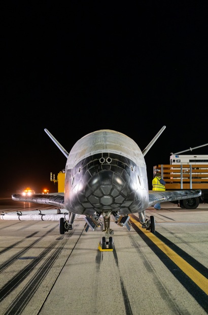

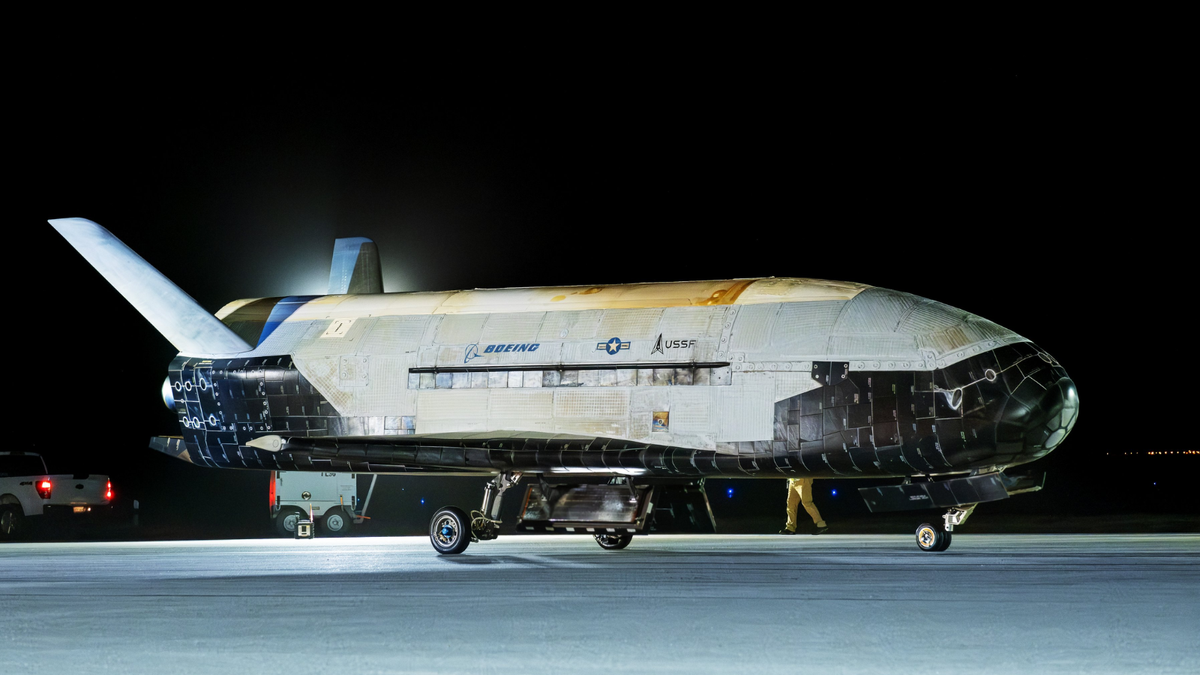

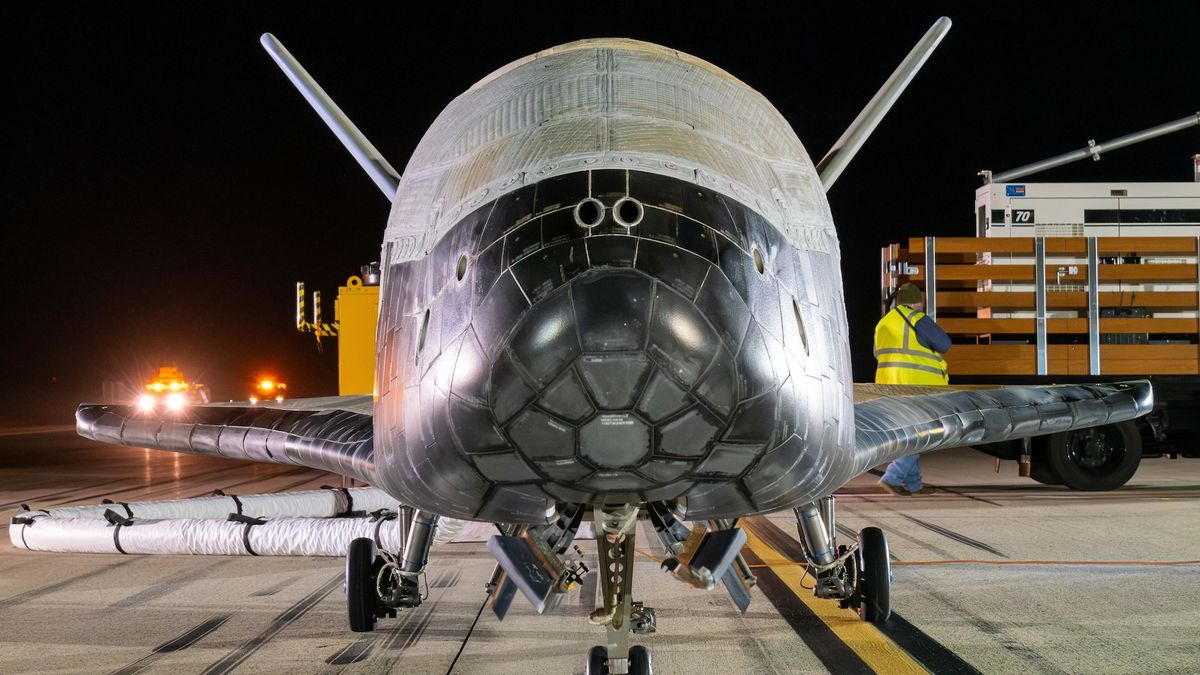
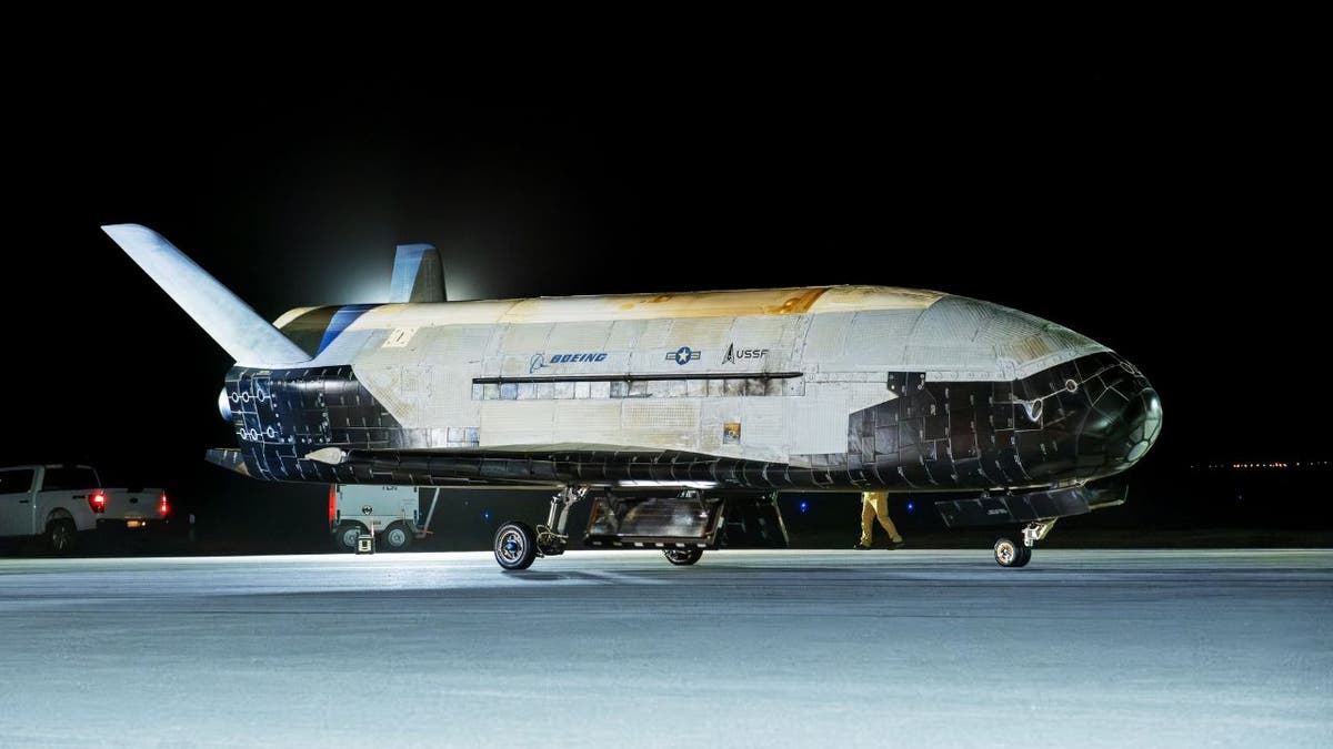
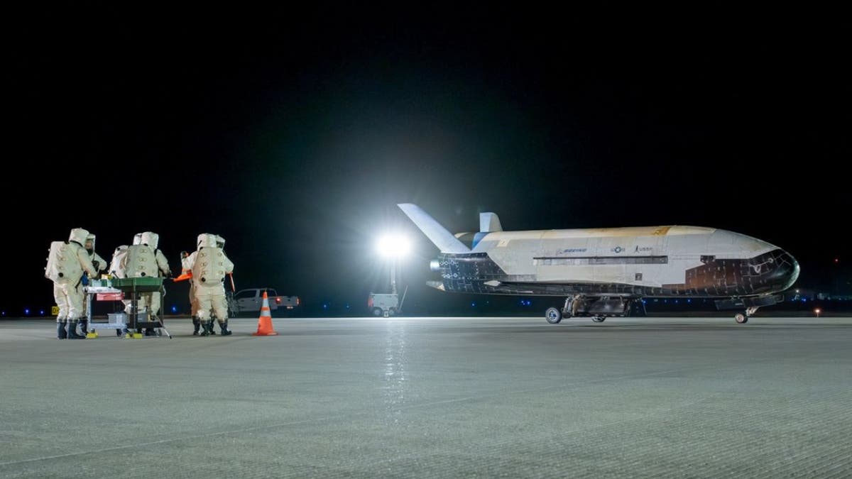

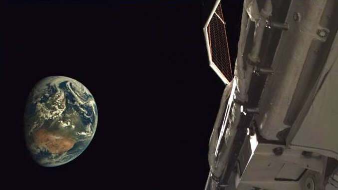


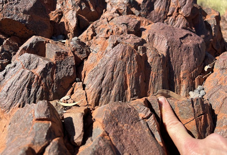


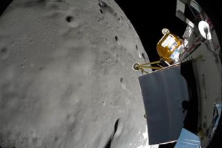

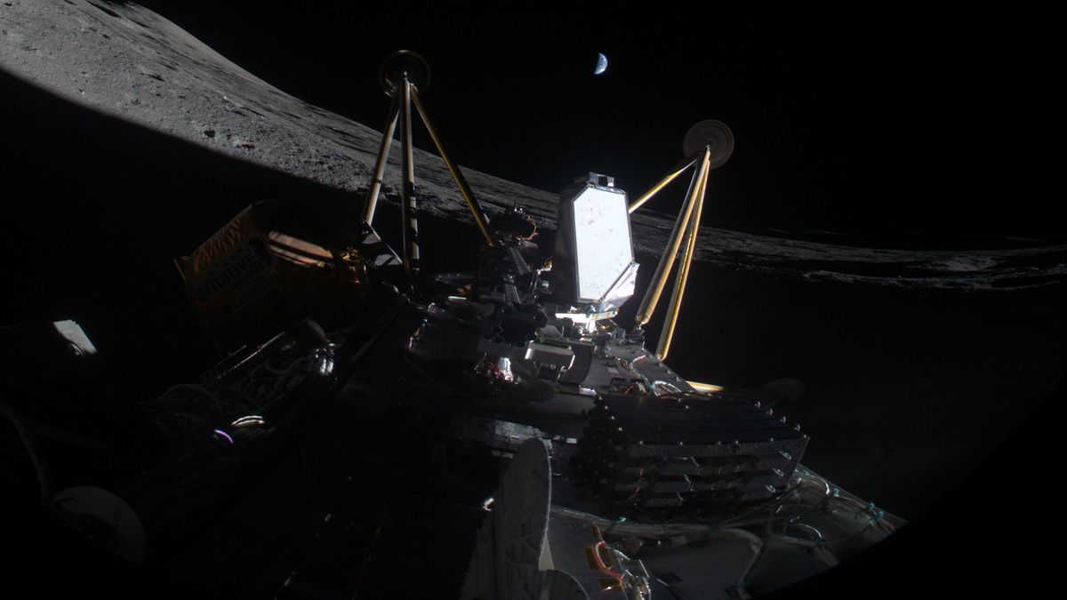


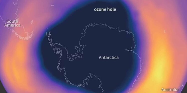


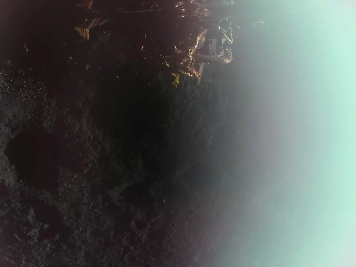
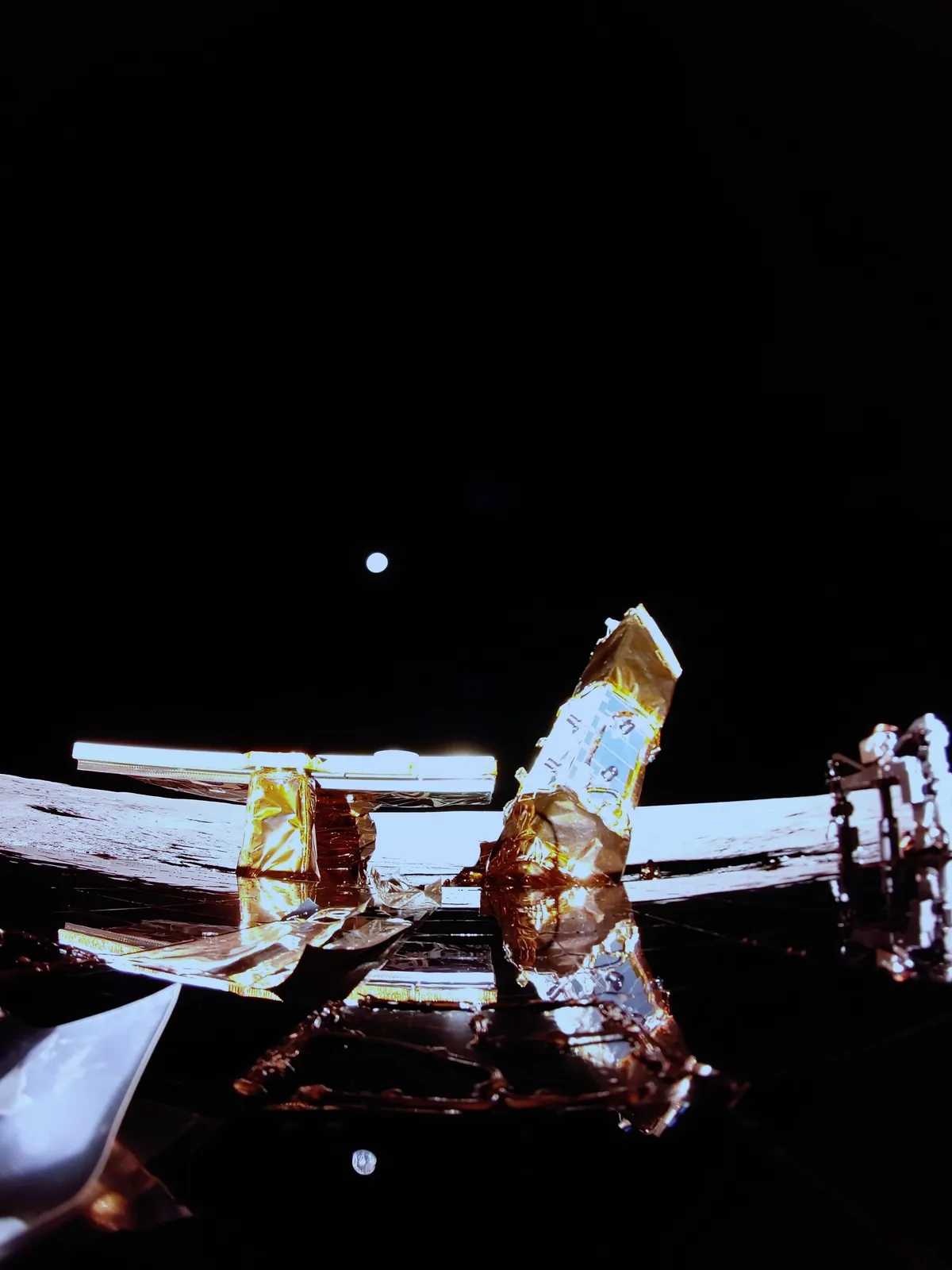
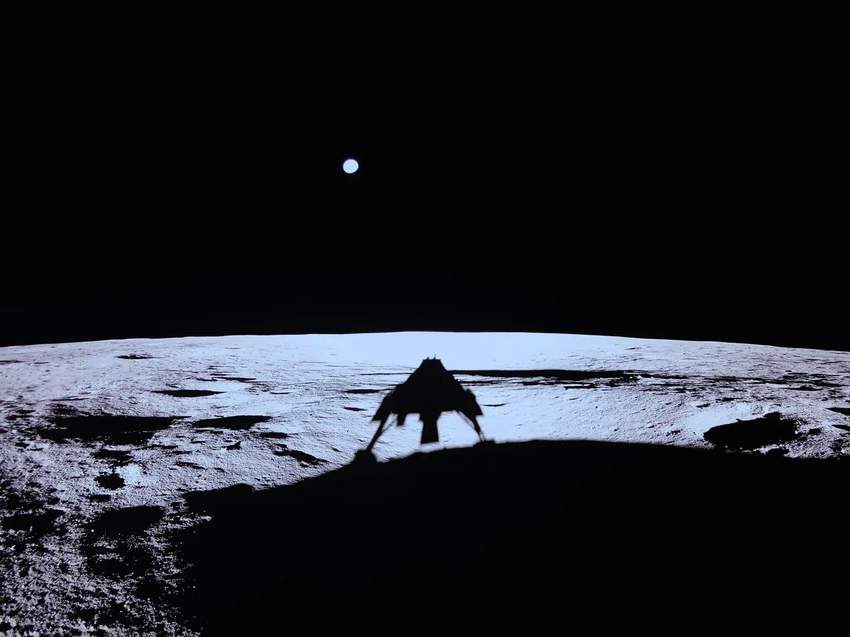


