The purpose of this blog is the creation of an open, international, independent and free forum, where every UFO-researcher can publish the results of his/her research. The languagues, used for this blog, are Dutch, English and French.You can find the articles of a collegue by selecting his category. Each author stays resposable for the continue of his articles. As blogmaster I have the right to refuse an addition or an article, when it attacks other collegues or UFO-groupes.
Druk op onderstaande knop om te reageren in mijn forum
Zoeken in blog
Deze blog is opgedragen aan mijn overleden echtgenote Lucienne.
In 2012 verloor ze haar moedige strijd tegen kanker!
In 2011 startte ik deze blog, omdat ik niet mocht stoppen met mijn UFO-onderzoek.
BEDANKT!!!
Een interessant adres?
UFO'S of UAP'S, ASTRONOMIE, RUIMTEVAART, ARCHEOLOGIE, OUDHEIDKUNDE, SF-SNUFJES EN ANDERE ESOTERISCHE WETENSCHAPPEN - DE ALLERLAATSTE NIEUWTJES
UFO's of UAP'S in België en de rest van de wereld Ontdek de Fascinerende Wereld van UFO's en UAP's: Jouw Bron voor Onthullende Informatie!
Ben jij ook gefascineerd door het onbekende? Wil je meer weten over UFO's en UAP's, niet alleen in België, maar over de hele wereld? Dan ben je op de juiste plek!
België: Het Kloppend Hart van UFO-onderzoek
In België is BUFON (Belgisch UFO-Netwerk) dé autoriteit op het gebied van UFO-onderzoek. Voor betrouwbare en objectieve informatie over deze intrigerende fenomenen, bezoek je zeker onze Facebook-pagina en deze blog. Maar dat is nog niet alles! Ontdek ook het Belgisch UFO-meldpunt en Caelestia, twee organisaties die diepgaand onderzoek verrichten, al zijn ze soms kritisch of sceptisch.
Nederland: Een Schat aan Informatie
Voor onze Nederlandse buren is er de schitterende website www.ufowijzer.nl, beheerd door Paul Harmans. Deze site biedt een schat aan informatie en artikelen die je niet wilt missen!
Internationaal: MUFON - De Wereldwijde Autoriteit
Neem ook een kijkje bij MUFON (Mutual UFO Network Inc.), een gerenommeerde Amerikaanse UFO-vereniging met afdelingen in de VS en wereldwijd. MUFON is toegewijd aan de wetenschappelijke en analytische studie van het UFO-fenomeen, en hun maandelijkse tijdschrift, The MUFON UFO-Journal, is een must-read voor elke UFO-enthousiasteling. Bezoek hun website op www.mufon.com voor meer informatie.
Samenwerking en Toekomstvisie
Sinds 1 februari 2020 is Pieter niet alleen ex-president van BUFON, maar ook de voormalige nationale directeur van MUFON in Vlaanderen en Nederland. Dit creëert een sterke samenwerking met de Franse MUFON Reseau MUFON/EUROP, wat ons in staat stelt om nog meer waardevolle inzichten te delen.
Let op: Nepprofielen en Nieuwe Groeperingen
Pas op voor een nieuwe groepering die zich ook BUFON noemt, maar geen enkele connectie heeft met onze gevestigde organisatie. Hoewel zij de naam geregistreerd hebben, kunnen ze het rijke verleden en de expertise van onze groep niet evenaren. We wensen hen veel succes, maar we blijven de autoriteit in UFO-onderzoek!
Blijf Op De Hoogte!
Wil jij de laatste nieuwtjes over UFO's, ruimtevaart, archeologie, en meer? Volg ons dan en duik samen met ons in de fascinerende wereld van het onbekende! Sluit je aan bij de gemeenschap van nieuwsgierige geesten die net als jij verlangen naar antwoorden en avonturen in de sterren!
Heb je vragen of wil je meer weten? Aarzel dan niet om contact met ons op te nemen! Samen ontrafelen we het mysterie van de lucht en daarbuiten.
03-01-2025
UK's biggest dinosaur footprint site is discovered with hundreds of massive tracks from 166 million years ago
Just a few hundred metres from the roaring traffic of the M40, scientists have uncovered a very different kind of road.
Around 166 million years ago Britain's 'dinosaur highway' was teaming with lumbering giants and fierce predators making their way across the country.
Researchers from the Universities of Oxford and Birmingham have uncovered a huge expanse of quarry floor filled with hundreds of different dinosaur footprints.
Scientists found five of the UK's most extensive dinosaur trackways, with the longest measuring 150m in length.
Four of these belong to long-necked herbivores - most likely Cetiosaurus, an 18-metre-long cousin of the Diplodocus.
These uniquely well-preserved tracks reveal some stunning insights into the lives of the long-extinct giants, even recording the moment two dinosaurs crossed paths.
And researchers say it is 'very likely' that there are still more tracks to be found.
Scientists have uncovered Britain's 'dinosaur highway' where giant herbivores and fierce predators would have passed 166 million years ago
In the Dewars Farm Quarry in Oxfordshire, palaeontologists have found more than 200 dinosaur footprints in five distinct sets of tracks
The tracks were found in the Jurassic limestone of the Dewars Farm Quarry in Oxfordshire.
Originally buried under clay, these new tracks were first spotted by quarry worker Gary Johnson when he felt 'unusual bumps' while stripping back the clay to reach the quarry floor.
Realising the significance of the find, experts were contacted and a full-scale excavation of the site began.
During June last year, more than 100 scientists and volunteers carefully uncovered over 200 fossilised footprints.
In addition to making casts of the prints for further study, the researchers also took more than 20,000 photographs to create a complete 3D model of the site.
However, the site was buried before the widespread use of digital cameras and drones so no 3D models of the tracks could be made.
That means this latest discovery is an especially valuable insight into a vibrant prehistoric ecosystem.
Four of the trackways belong to a long-necked sauropod, most likely the 18-metre-long Cetiosaurus (right). The last remaining set belonged to a Megalosaurus (left), a ferocious predator which grew up to nine metres in length
The trackways extend up to 150 metres along the quarry bed and were discovered when a worker noticed 'unusual bumps' in the limestone
How do fossil footprints form?
Just like any animal, when dinosaurs walked through mud they left tracks behind.
When these are made near water soft silt or clay can be washed into the track, preserving its shape.
Over time, the tracks become buried by layers of sediment and the soft materials turn to stone.
When the layers of stone are exposed by geological changes or human activity we can still see the traces of the dinosaur's footprint preserved in the stone.
These footprints are vital clues for palaeontologists to understand how dinosaurs moved and behaved.
Dr Duncan Murdock, a palaeontologist from Oxford University, told MailOnline: 'As the feet of the giant animals, some up to 10 tonnes, went into the mud they left behind both an impression of the foot and a rim of displaced mud around the print.
That thick mud has preserved such incredible levels of detail that scientists can see how the mud was deformed as the dinosaurs' feet squelched in and out.
'Unlike fossil bones, finds like these tell us about the behaviour of extinct animals,' says Dr Murdock.
Each three-toed Megalosaurus track is around 65cm in length and 2.7m apart.
Based on those measurements, scientists estimate that this ancient predator would have been ambling along at around three miles per hour (five kmph) - roughly the same as a human's walking speed.
By looking at the size and distribution of the footprints, scientists are able to work out how the dinosaurs moved and how fast they were going at the time
The Megalosaurus (left) produced footprints that are 65cm in length and was likely moving at around three miles per hour (five kmph). The sauropod produced huge 90cm footprints (right) and is believed to have been moving at a similar speed to human walking pace
At one point in the track, palaeontologists even discovered a point where a Megalosaurus and sauropod crossed paths.
Based on the disturbances in the mud, the scientists believe that the sauropod passed through first, followed by the Megalosaurus sometime later.
Dr Murdock says: 'Where trackways cross we get a glimpse of the potential interactions between different species like the carnivorous Megalosaurus and the giant herbivorous sauropods.'
And as exciting as these discoveries already are, experts say there could still be more to find.
Professor Kirsty Edgar, a micropalaeontologist from the University of Birmingham, told MailOnline that it is 'very very likely' that more tracks will be found.
She says: 'When the animal walks over a surface and leaves an impression in soft sediment so [tracks are] most commonly found around river, lake lagoon margins or coastal environments more generally.'
Additionally, the Dewars Farm quarry is still actively extracting layers of rock above the trackway surface which means there may be more discoveries to come as the Jurassic limestone is exposed.
Smiths Bletchington, the quarry's operators, are working with Natural England to explore options to preserve the site for the future.
So the scientists, from University College London and Aberystwyth University, theorise that Scottish and Welsh people brought their own local stones down to Wiltshire as a well-meaning contribution to assembling the structure.
In that sense, it represented a powerful – and very early – symbol of British unity.
Stonehenge's builders had attempted to establish 'political unification and shared identity across much or even all of Britain', the authors say in their paper, published in Archaeology International.
They add: 'Bringing together these extraordinary and alien rocks... symbolised and embodied far and distant communities within a complex material.
A symbol of British unity? Wiltshire's famous stone circle is one of the world's most iconic historic sites and a British cultural icon - but its intended purpose has long divided academics
The new research comes a day before the winter solstice - the shortest day of the year where thousands of people flock to Stonehenge (pictured in 2021)
'[Stonehenge was a] monumental expression of unity between people, land, ancestors and the heavens.'
In the paper, the researchers say Stonehenge’s long-distance links add weight to the theory that the Neolithic monument may have had some unifying purpose in ancient Britain, to go with its symbolic value.
'The fact that all of its stones originated from distant regions, making it unique among over 900 stone circles in Britain, suggests that the stone circle may have had a political as well as a religious purpose,' said lead author Professor Mike Parker Pearson at UCL's Institute of Archaeology.
'[It was] a monument of unification for the peoples of Britain, celebrating their eternal links with their ancestors and the cosmos.'
Even though England, Scotland and Wales did not exist as concepts when Stonehenge was built 5,000-odd years ago, we know the structure is indeed representative of all three countries.
Stonehenge is famous for its great sandstone slabs, known as sarsens, which were sourced locally – likely hauled from West Woods in Wiltshire, around 15 miles north.
But in addition to the tall Sarsen stones that make up Stonehenge's distinctive appearance, the world-famous site is also home to around 80 'bluestones' – smaller stones that have a bluish tinge when freshly broken or when wet.
Researchers say Stonehenge's Altar Stone (pictured) came from Scotland. Lying flat at the heart, the six-tonne, five-metre-long rectangular Altar Stone is a grey-green sandstone
Meanwhile, around 80 smaller 'bluestones' (pictured) - stones that have a bluish tinge when freshly broken or when wet - came from Wales
How were the stones moved to Wiltshire?
The matter of why Stonehenge was built is perhaps the most tantalizing question for academics - but there's the additional question of how.
Scientists know that the sarsens were sourced locally in Wiltshire, while the 'bluestones' were from Wales and the 'Altar Stone' from Scotland.
But this raises questions about its journey given the limits of human technology during Neolithic times.
It's possible that they were pulled by tribes of men along the ground using a series of logs - a labor-intensive task that would have taken months if not years.
However, the Altar Stone, the largest bluestone at the centre of Stonehenge, actually came from northern Scotland – up to 1,000km (621 miles) away, scientists revealed earlier this year.
Lying flat at the heart of Stonehenge, the six-tonne, five-metre-long rectangular Altar Stone is a grey-green sandstone, far bigger and different in its composition from the other bluestones.
At the time, the research team (which included two authors of this new paper) analysed the age and chemistry of minerals from fragments of the Altar Stone.
They found a remarkable similarity with the Old Red Sandstone of the Orcadian Basin in northeast Scotland.
In this new follow-up paper, the team say the Altar Stone was brought by the Neolithic people of northern Scotland as a contribution or gift to the southerners.
'[This was] perhaps to cement an alliance or to take part in the extraordinary long-distance collaboration that building Stonehenge represented and embodied,' the authors say.
Likewise, the bluestones could have been transported by people from the Preseli Hills of south-west Wales as their own contribution – illustrating 'a political unification or a sacred peace'.
Earlier in 2024, researchers concluded that the Altar Stone came from the Orcadian Basin in northeast Scotland
What is the Altar Stone?
The Altar Stone is a six-tonne sandstone slab that lies flat at the centre of Stonehenge.
The five-metre-long rectangular Altar Stone is a grey-green sandstone, far bigger and different in its composition from the other bluestones.
Researchers say the Altar Stone came from Scotland - potentially transported south by a Scottish tribe as their contribution to building Stonehenge.
The Altar Stone may have once stood vertically at Stonehenge before falling to lie parallel with the ground.
This follow-up paper now identifies Stonehenge construction 'as a monument of island-wide unification, embodied in part through the distant and diverse origins of its stones'.
'Unusually strong similarities in house floor layouts between Late Neolithic houses in Orkney and the Durrington Walls settlement near Stonehenge also provide evidence of close connections between Salisbury Plain and northern Scotland,' the team say.
Stonehenge was used as a cremation cemetery for mostly adult men and women for around five centuries in its early history.
Nearly half the people buried at Stonehenge had lived somewhere other than Salisbury Plain, the experts say – showing people historically flocked there from afar.
'The similarities in architecture and material culture between the Stonehenge area and northern Scotland now make more sense,' added Professor Pearson.
'It’s helped to solve the puzzle of why these distant places had more in common than we might have once thought.'
The new research comes a day before the winter solstice – the shortest day of the year where thousands of people flock to Stonehenge.
During the winter solstice, the setting sun dips below the horizon over the middle of the Altar Stone and between the two largest upright stones (one of which is now fallen).
Stonehenge is famous for its alignment with the sun, but the ancient monument may have also been carefully designed to align with the movements of the moon
In the northern hemisphere, the summer solstice occurs when Earth's north is most greatly inclined towards the sun, and the winter solstice occurs when it's titled away from the sun
Read More
Stonehenge's biggest remaining mysteries: The five key unanswered questions
For thousands of years, it's thought people gathered at Stonehenge at both midsummer and midwinter solstices to conduct rituals and ceremonies relating to the changing seasons, the sun and the sky.
During the winter, Neolithic people also feasted close to Stonehenge at the nearby settlement village of Durrington Walls.
Largely because it's a whopping 5,000 years old, the origins of Stonehenge, including why and how it was built, are still a source of frenzied debate.
Professor Timothy Darvill, an archaeologist at Bournemouth University who passed away earlier this year, said Stonehenge served as an ancient solar calendar, helping people track the days of the year.
The British researcher said the sarsens each represented a single day in a month, making the entire site a huge time-keeping device.
Other theories include that it was a cult centre for healing, a temple or a place where ancestors were worshipped.
Stonehenge and the solstices
It's already well known that the whole layout of Stonehenge is positioned in relation to the summer and winter solstices – when the Earth's tilt towards the sun is at its most extreme, either at the north or south pole.
In the northern hemisphere, the summer solstice occurs when Earth's north is most greatly tilted towards the sun, and the winter solstice occurs when it's titled away from the sun.
Stonehenge was deliberately built to align with the sun on the solstices, according to English Heritage, which manages the site.
It explains: 'At Stonehenge on the summer solstice, the sun rises behind the Heel Stone in the north-east part of the horizon and its first rays shine into the heart of Stonehenge.
'Observers at Stonehenge at the winter solstice, standing in the enclosure entrance and facing the centre of the stones, can watch the sun set in the south-west part of the horizon.'
Scientists Finally Crack Stonehenge Mystery
HOW Scientists FINALLY CRACKED The Stonehenge Mystery!
Incredible Details of the 26-Million-Year Cycle of Mass Extinctions Recorded in Ancient Vedic Texts
Incredible Details of the 26-Million-Year Cycle of Mass Extinctions Recorded in Ancient Vedic Texts
Bibhu Dev Misra
The idea that human civilization has been gradually evolving over time in a linear manner, is a relatively new concept that was formulated during the period of colonization. Nearly every ancient culture believed otherwise. They said that time moves in cycles, smaller and larger, and that our civilization has gone through innumerable ups and downs over eons. With the emergence of new scientific data, it is becoming increasingly obvious that the ancients knew what they were talking about, and we have been far too quick to denounce the collective wisdom of our ancestors as the flights of fancy of primitives.
The concept of the Yuga Cycle or the Great Year was known to most ancient cultures, and, as per this framework, we have devolved from an erstwhile Golden Age of illumination, harmony and abundance to the current age of greed and lies, discord and scarcity. The fundamental factor that differentiates a higher age from a lower one is the state of man’s consciousness. In a Golden Age, consciousness is so elevated and purified, that we can easily comprehend the mysteries of creation, and of our place in the wider scheme of things, and, thus, we are able to lead long lives in a state of joy, balance and harmony. Since the environment reflects our state of consciousness, there is fertility and abundance in the higher ages and a lack of diseases and natural disasters. But as we devolve along the descending arc of the Yuga Cycle or Great Year, we move from soul consciousness to ego consciousness, accompanied by a degradation in our physical size and the external environment, which gradually leads to a burgeoning of violence, misery and discontent in society.
What is really striking is that all of these claims are now being borne out by scientific findings from different disciplines. It turns out that, over the past 12,000 years of the descending arc of the Yuga Cycle, humans have shrunk in size by at least 10%, along with a corresponding decline in bone strength and athleticism. This has been accompanied by a 10% to 17% reduction in our cranial volume over the same period, which has not only diminished the average intellect but reduced our memory and atrophied our sense of judgment and morality, along with a host of subtle mental abilities such as foresight, telepathy etc. And to add to these surprising statistics, it turns out that, towards the end of the last Ice Age, there was no food scarcity or diseases, but as time went on, food sources became scarce, many kinds of diseases became endemic, and incidences of violent deaths increased substantially.
Everything that the ancients said about the Yuga Cycle or Great Year is now turning out to be facts, but why aren’t these statistics being discussed on mainstream media outlets? It’s because they run counter to the Darwinian myth of gradual evolution by natural selection that has been literally shoved down our throats and turned into an incontrovertible dogma. Very few scientists, academics or media channels will dare to question Darwinism, for fear of getting ridiculed, denied funds or promotions, or even hounded out of their profession. Do not question the science, is the current science. This, unfortunately, is the insidious manner in which things work in the Kali Yuga, the darkest age of human history.
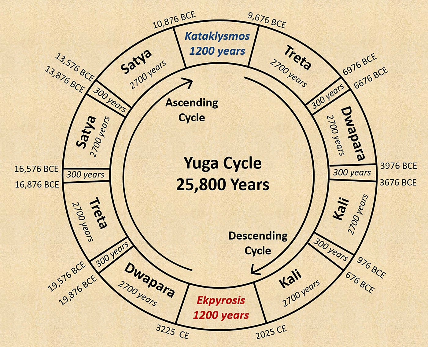
In my book, Yuga Shift, I have presented what I believe is the original Yuga Cycle framework. It is of the same duration as the precessional cycle of the earth, i.e. 25,800 years, and comprises an ascending cycle of consciousness and a descending cycle of consciousness, which are separated by two extended periods of transition that the Greeks called Kataklysmos (meaning “Deluge”) or the “great winter” of the Great Year, and Ekpyrosis (meaning “Conflagration”) or the “great summer” of the Great Year.
It is the period of Ekpyrosis that we are heading towards, as the Kali Yuga and the entire descending cycle of consciousness come to an end in 2025.
The 25,800-year Yuga Cycle. The ascending and descending cycles are separated by two extended periods of transition, called Kataklysmos and Ekpyrosis. Credit: Bibhu Dev Misra.
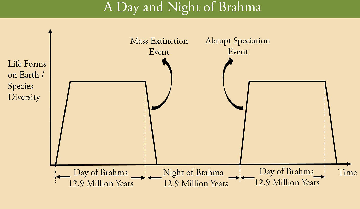
A Day and Night of Brahma
One of the thoughts that come to mind when we think about the Yuga Cycle or the Cycle of the Ages is that, does it continue indefinitely, without any beginning or end, or is it part of an even larger cycle of time.
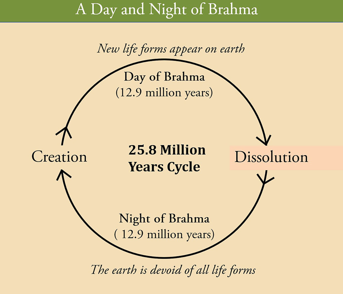
As per the ancient Vedic texts, there is an even longer cycle of time called the “Day and Night of Brahma”, which extends for a whopping 25.8 million years! It consists of a “Day of Brahma” which extends for a thousand Yuga half-cycles of 12,900 years each, adding up to 12.9 million years. A “Day of Brahma” is followed by a “Night of Brahma” of equal duration. This cycle has been described in a number of texts.
As per the Vishnu Purana, at the beginning of a “Day of Brahma”, the world is created from unmanifested matter by Brahma, who is the pure, eternal, formless, consciousness, seated at the navel of the world. At the end of a “Day of Brahma”, the entire creation is destroyed and turns into a mighty, formless ocean. This is followed by a “Night of Brahma” when no life forms exist. The creative process begins once again at the beginning of the next “Day of Brahma”.
“At the end of this day (i.e. “Day of Brahma”) a dissolution of the universe occurs, when all the three worlds, earth, and the regions of space, are consumed with fire…When the-three worlds are but one mighty ocean, Brahma…satiate with the demolition of the universe, sleeps upon his serpent-bed…for a night of equal duration with his day (i.e. Night of Brahma); at the close of which he creates anew.”[1]
In the Bhagavad Gita, Lord Krishna provides a specific value for the duration of the “Day and Night of Brahma”.
“Those who understand the cosmic laws know that the Day of Brahma ends after a thousand Yugas and the Night of Brahma ends after a thousand Yugas. When the Day of Brahma dawns, forms are brought forth from the Unmanifest; when the Night of Brahma comes, these forms merge in the Formless again. This multitude of beings is created and destroyed again and again in the succeeding days and nights of Brahma.”[2]
It should be remembered here that, when the Sanskrit texts talk of the Yuga Cycle, they mean the Yuga half-cycle, which goes from Satya Yuga -> Treta Yuga -> Dwapara Yuga -> Kali Yuga, including the periods of transition between them. A 1000 Yuga half-cycles is equivalent to 500 complete Yuga Cycles of 25,800 years each, which works out to 12.9 million years.
A “Day and Night of Brahma” spans 25.8 million years, and consists of a “Day of Brahma” of 12.9 million years and a “Night of Brahma” of equal duration. Credit: Bibhu Dev Misra.
A “Day of Brahma”, therefore, extends for 12.9 million years, during which time we experience a long sequence of 500 complete Yuga Cycles, and the earth is bustling with life and civilization. It is followed by a “Night of Brahma” of equal duration of 12.9 million years, when all life is snuffed out, and the entire world exits as a giant, formless, lifeless ocean. Thus, the “Day and Night of Brahma” is a grand cosmic cycle of creation and dissolution spanning over of 25.8 million years.
It is easy to see that the time period between two successive dissolution events in this cycle is 25.8 million years, which can be rounded off to 26 million years. Now, if a dissolution of life on a cosmic scale occurs every 26 million years, shouldn’t this fact be reflected in the fossil records of our planet?
Amazingly enough, this is exactly what has been indicated by recent paleontological evidence: every 26 million years there is a mass extinction of species on the earth!
Mass Extinction Cycle
Around 67 million years ago, the earth looked like a very different place. Enormous dinosaurs stalked the landscape, while massive avian reptiles patrolled the skies. But, then, something catastrophic happened, which changed things almost overnight. Nearly 66 million years ago the earth went through a period of rapid death, called a mass extinction, when more than 75% of all animal and plant species became extinct. Scientists now have evidence that the die-off was caused when an asteroid, about 10 kilometers in diameter, struck the earth at a speed of about 20 km/sec and created the 200-km wide Chicxulub Crater in southeastern Mexico, releasing a billion times more energy than the atomic bombs dropped on Hiroshima.
The extinction of the dinosaurs was caused by an asteroid impact at the K-T boundary, nearly 66 million years ago. Source: Adobe Stock.
The impact generated hot winds and shock waves, and ejected a gigantic jet of molten material, several times hotter than the surface of the sun, which set fire to everything within a thousand miles. Measurements of the layer of ash and soot that eventually coated the Earth indicate that fires consumed about seventy percent of the world’s forests. The collision triggered powerful earthquakes and spawned mega tsunamis, hundreds of feet tall. A model of the impact event developed by scientists at Los Alamos National Laboratory shows,
“The dust and soot from the impact and the conflagrations prevented all sunlight from reaching the planet’s surface for months. Photosynthesis all but stopped, killing most of the plant life... After the fires died down, Earth plunged into a period of cold, perhaps even a deep freeze. Earth’s two essential food chains, in the sea and on land, collapsed. About seventy-five percent of all species went extinct. More than 99.9999 percent of all living organisms on Earth died, and the carbon cycle came to a halt.”[3]
It is to be noted here that the impact event at the K-T boundary effectively killed off all the living organisms on our planet, even though the species die-off is estimated at roughly 75%. This is because some of the species that existed at that time, re-appeared in the fossil records at a later date, and therefore, is not considered to have gone extinct.
The fiery cataclysm that led to the extinction of the dinosaurs is in perfect alignment with the description of the dissolution event that occurs at the end of a “Day of Brahma” when all life forms on the earth are destroyed, and, as the Vishnu Purana states, “all the three worlds, earth, and the regions of space are consumed with fire”. Admittedly, the ancient Vedic sages knew a thing or two about the true history of our planet.
The asteroid impact at the K-T boundary released a billion times more energy than the atomic bombs dropped on Hiroshima. Source: Adobe Stock.
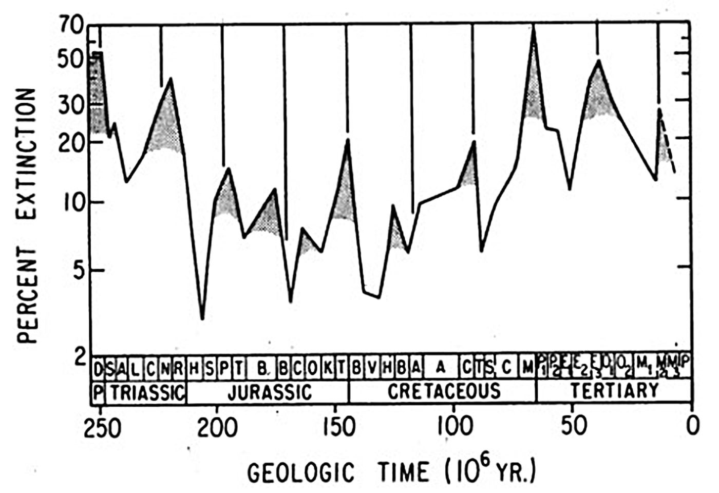
Moreover, this is not the only mass extinction event that has occurred on our planet in the past. There are many more, and, quite surprisingly, they occur in a cyclical manner every 26 million years!
In 1984, paleontologists David Raup and Jack Sepkoski of the University of Chicago identified a 26-million-year periodicity in extinction rates over the past 250 million years.[4] As part of a broad study of the distribution of marine life through geologic time, Sepkoski had prepared a listing of about a quarter of a million species of sea-dwelling creatures, both extinct and current, noting the point in time where they appeared and became extinct. The study was confined to marine organisms since the chances of finding fossils are much higher under the sea. The oceans are areas of net sedimentation, whereas land is an area of net erosion.
David Raup, a senior colleague at the University of Chicago, suggested to Sepkoski that he examine the list for any evidence of a pattern in the timing of the mass extinctions. Sepkoski decided to concentrate on the last 250 million years of geologic time and throw out animals whose exact timing of appearance and disappearance were debated. He was left with about 500 of his original 3,500 marine families (250,000 species). Sepkoski put the data through a computer program and was surprised to find that life forms on Earth disappeared in great numbers every 26 million years. Both of them checked for errors and confirmed the pattern; life seemed to disappear drastically exactly every 26 million years. In their seminal paper, Raup and Sepkoski wrote:
“The temporal distribution of the major extinctions over the past 250 million years has been investigated statistically using various forms of time series analysis. The analyzed record is based on variation in extinction intensity for fossil families of marine vertebrates, invertebrates, and protozoans, and contains 12 extinction events. The 12 events show a statistically significant periodicity (P <0.01) with a mean interval between events of 26 million years. Two of the events coincide with extinctions that have been previously linked to meteorite impacts (terminal Cretaceous and late Eocene). Although the causes of the periodicity are unknown, it is possible that they are related to extraterrestrial forces (solar, solar system, or galactic.)”
The mass extinction data of the past 250 Myr shows that the extinction rate peaks every 26 million years. Source: Raup and Sepkoski (1984)
The mass extinction events are not selective at all, in the way Darwin had proposed. As per Darwinism, the evolutionary process is gradual, and life forms evolve slowly through a process of natural selection, in which the inferior life forms are eliminated since they are less suited to the struggle for existence. However, in case of a mass extinction, there is no way of knowing beforehand which species will survive the extinction event and which will die out. The process is entirely random. In a paper titled, “The Role of Extinction in Evolution” (1982), David Raup wrote,
“The largest mass extinctions produce major restructuring of the biosphere wherein some successful groups are eliminated, allowing previously minor groups to expand and diversify…There is little evidence that extinction is selective in the positive sense argued by Darwin. It has generally been impossible to predict, before the fact, which species will be victims of an extinction event.”[5]
The 26-million-year extinction cycle has, since then, been validated by a number of independent studies. In 2010, Adrian Melott and Richard Bambach identified a 27 Myr periodicity in the extinction data, extending over the past 500 million years. They wrote,
“We examined periodicities in extinction over the last 500 million years, and concluded that a signal detected by Raup & Sepkoski (1984) was present in better resolved, more extensive current data, over a longer time period than they had originally claimed, and at a higher level of significance. The claimed period grew from 26 to 27 Myr, and is also now observed to extend over the entire 500 million years interval rather than just the last 250 million years, due to revisions in the geological timescale since the 1980s.”[6]
Mass Extinctions and Impact Craters
It has become quite obvious over time that the primary triggers for the mass extinctions are impact events. In 1980, the father-son duo of the Nobel Prize-winning physicist Luis Alvarez and his son, the geologist Walter Alvarez, had inferred that the sudden extinction of dinosaurs at the K-T (Cretaceous–Tertiary) boundary, nearly 66 million years ago, was due to the impact of a large asteroid or comet.
Luis and Walter Alvarez had noticed that sedimentary layers all over the world at the K-T boundary contain a concentration of iridium many times greater than normal. Iridium is extremely rare in the Earth's crust but is abundant in chondritic meteorites and asteroids. Moreover, the isotopic ratio of iridium in asteroids is similar to that seen in the K–T boundary layer. Based on this, the Alvarez team suggested that the iridium spike at the K-T boundary was of extraterrestrial origin and had settled out of a global dust cloud triggered by the impact of an asteroid, at least 10 km in diameter.
While Alvarez’s theory was initially rejected by most paleontologists, the subsequent discovery and dating of the Chicxulub Crater in Mexico validated their findings and silenced the dissenters.
Since then, other scientists have found that the estimated ages of a number of impact craters coincide with the mass extinction events.
In the mid-1980s, cratering specialist Richard Grieve ran his list of well-dated impact craters through the computer at NASA’s Goddard Institute for Space Studies and identified a crater periodicity of nearly 30 million years. Around the same time, Walter Alvarez and Richard Muller at UC Berkeley identified a 28 million-year cycle using a somewhat different set of craters.
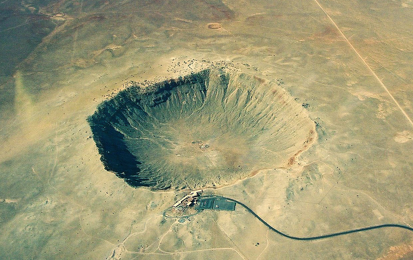
An aerial photograph of the Barringer Meteor Crater in Arizona, USA, which was created about 50,000 years ago. Credit: LarryBloom, CC BY 3.0 via Wikimedia Commons
In 2015, Michael Rampino and his student Ken Caldeira studied more impact craters with improved crater-age data, and “found that craters and extinctions both seem to occur with the same 26 million-year cycle”.[7] Crater formation rate peaks close to the time of an extinction event, and some of the largest impact craters were formed during an extinction event. Clearly, the 26 million-year extinction cycle is a significant geological signal, which some scientists call the “geological heartbeat” of our planet.
It is nothing short of astonishing that, such precise information about the 26-million-year mass extinction cycle has been specified in the Vedic texts. Of course, a couple of questions still need to be clarified. The Vedic doctrine claims that the earth remains entirely devoid of all life forms for the entire 12.9-million-year duration of the “Night of Brahma” that follows the extinction event. Do have any scientific evidence in support of this? As it turns out, there is. And more studies are arriving at the same conclusion.
Another image depicting the mass extinction event and rapid speciation event occurring in a “Day and Night of Brahma”. Credit: Bibhu Dev Misra
The Night of Brahma
In May 2012, an article in Nature Geoscience written by Dr. Zhong-Qiang Chen of the China University of Geosciences in Wuhan and Professor Michael Benton of the University of Bristol stated that it took nearly 10 million years for life forms to appear after the end-Permian mass extinction event 250 million years ago, which had wiped out nearly 90% of all living species.[8]
As per the scientists, two factors could have delayed the appearance of new life forms: 1) the sheer intensity of the crisis, and 2) the continuing grim conditions on earth after the first wave of extinction.[9] Professor Michael Benton wrote that “in this most devastating case, life did recover, after many millions of years, and new groups emerged. The event had re-set evolution.”[10]
Another study conducted in 2019 found that it takes at least ten million years before the diversity of a species achieves a similar level to that seen before the mass extinction event.[11] Dr. Lowery and Dr. Fraass studied foram fossils for a time period covering roughly 20 million years, from the end of the Cretaceous mass extinction (66 million years ago) and extending through the ensuing recovery, to determine how long it took these minibeasts to recover their species diversity. Dr. Lowery and Dr. Fraass concluded that it took at least ten million years for foram species diversity to recover.[12]
These studies confirm that, in general, it takes around 10 million years or more for life forms to emerge and global biodiversity to recover, after a mass extinction event. This confirms what Vedic sages said about the “Night of Brahma” being a time when the earth is devoid of life forms.
The other question that was on my mind is this: As per the Vedic doctrine, life forms arise very quickly after a “Night of Brahma” ends, and the next “Day of Brahma” begins. Now, does this really happen? Do we see a sudden emergence of life forms after a mass extinction event, or do they appear gradually through a process of natural selection extending over millions of years, as Darwin had proposed?
Punctuated Equilibrium
Darwin’s theory that new species arise by the slow and steady transformation of entire populations is not reflected in the fossil records. If this were true, then a continuous sequence of “intermediate forms”, showing incremental changes on the way to a new species, should have been found in the rock strata. Unfortunately, intermediate forms connecting species have never been identified. The absence of “missing links” had also concerned Darwin, who attributed it to the imperfections of the geological record. In the Origin of Species, Darwin wrote,
“Why then is not every geological formation and every stratum full of such intermediate links? Geology assuredly does not reveal any such finely graduated organic chain; and this, perhaps, is the most obvious and gravest objection which can be urged against my theory.”[13]
“The geological record is extremely imperfect and this fact will to a large extent explain why we do not find interminable varieties, connecting together all the extinct and existing forms of life by the finest graduated steps. He who rejects these views on the nature of the geological record will rightly reject my whole theory. ”[14]
In 1972, Harvard University paleontologists Stephen Jay Gould and Niles Eldredge wrote their seminal paper titled, “Punctuated Equilibria: an alternative to phyletic gradualism”, in which they argued that the fossil record is not imperfect, as claimed by Darwinists. The many breaks in the fossil records are real, and they express how evolution occurs. The absence of transitional forms implies that evolution does not occur by the slow and gradual transformation of a species.
“Under the influence of phyletic gradualism, the rarity of transitional series remains as our persistent bugbear…Many breaks in the fossil record are real; they express the way in which evolution occurs, not the fragments of an imperfect record. The sharp break in a local column accurately records what happened in that area through time.”[15]
“Although phyletic gradualism prevails as a picture for the origin of new species in paleontology, very few classic examples purport to document it. A few authors have offered a simple a literal interpretation of this situation: in-situ, gradual, progressive evolutionary change is a rare phenomenon. But we usually explain the paucity of cases by a nearly ritualized invocation of the inadequacy of the fossil record.”[16]
Gould and Eldredge proposed the theory of Punctuated Equilibrium to explain what is really happening in the fossil records. They said that the fossil records show long periods of stasis or equilibrium, extending for millions of years, during which time there is little or no evolutionary change, which are punctuated by rapid, episodic periods of speciation, occurring within the space of a few thousand years.
Gould provided further clarification in his article titled, “Evolution’s Erratic Pace (1977)”, in which he wrote that, in any local area, “a species does not arise gradually by the steady transformation of its ancestors; it appears all at once and fully formed”[17]. Once a species appears, it undergoes very little or no evolutionary change for millions of years. Most species, “appear in the fossil record looking much the same as when they disappear; morphological change is usually limited and directionless.”[18]
Gould berated the paleontological community for being so heavily influenced by Darwin’s theory of gradual evolution, that they did not notice the obvious patterns in the fossil records.
“The extreme rarity of transitional forms in the fossil record persists as the trade secret of paleontology…Paleontologists have paid an exorbitant price for Darwin's argument. We fancy ourselves as the only true students of life's history, yet to preserve our favored account of evolution by natural selection we view our data as so bad that we never see the very process we profess to study.”[19]
Gould was one of the most influential and widely read authors of popular science of his generation. He wrote 300 popular essays in the Natural History magazine, for both specialists and non-specialists. In April 2000, the US Library of Congress named him a “Living Legend”. Throughout his career, Gould insisted that the gradualistic models of evolution are simply not reflected in the fossil records, and there is a strong tendency within the scientific community to restrict their thinking within certain belief systems.
In the essay, “Darwin's Untimely Burial” (1976), Gould gave vent to his frustration when he wrote, “I am a strong advocate of the general argument that “truth” as preached by scientists often turns out to be no more than prejudice inspired by prevailing social and political beliefs.”[20]
In “The Return of Hopeful Monsters” (1977), he wrote that, “all paleontologists know that the fossil record contains precious little in the way of intermediate forms; transitions between major groups are characteristically abrupt.” Then, in the essay titled, “Is a New and General Theory of Evolution Emerging?” (1980), Gould reiterated the obvious flaws in the Darwinian model of evolution:
“The absence of fossil evidence for intermediary stages between major transitions in organic design, indeed our inability, even in our imagination, to construct functional intermediates in many cases, has been a persistent and nagging problem for gradualistic accounts of evolution.”[21]
The truth is that when we go purely by the fossil records – leaving aside all theories and speculations - what we see are rapid bursts of speciation and not the long-drawn-out gradual accumulation of small variations.
Gould’s Harvard colleague, Niles Eldredge, estimated that the rapid periods of evolutionary change, “took something between 5,000 and 50,000 years—a mere blink of an eye geologically speaking.”[22]
It is equally fascinating that this estimate is very close to the value mentioned in the Surya Siddhanta, which is the oldest astronomical treatise of India. The text states: “One hundred times four hundred and seventy-four years passed while the All-Wise was employed in creating the animate and inanimate creation, plants, stars, gods, demons and the rest.”[23] This means the entire creative process (possibly at the beginning of the current Day of Brahma) took 47,400 years, which falls in the range of values found by Eldredge i.e. between 5000 – 50,000 years.
Oscillations in Morphology
Once speciation is completed, every species remains amazingly stable for millions of years. That does not mean that they do not change at all. In his study of Devonian trilobites, which lived between 380-375 million years ago, Eldredge had found that, once a new species appeared, they persisted for millions of years with very little morphological change.
“There were some oscillations in morphology, so species weren’t completely invariant, but the net sum of any changes usually tended to cancel out, leading to no net change.”[24]
Gould, by the way, had also found very similar patterns in his studies that focused on fossil land snails from the genus Poecilozonites that lived a few hundred thousand years ago during the Pleistocene.[25]
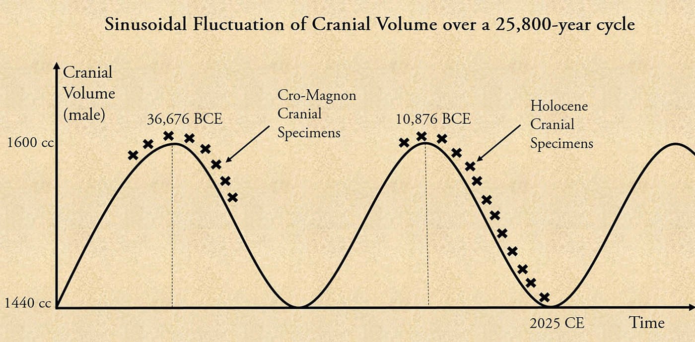
I was amazed to know of these findings because this is precisely what I had discovered in course of my explorations into the Yuga Cycle. In Yuga Shift, I had proposed, based on ample data points, that, both human cranial volume as well as physical size fluctuates in a sinusoidal manner over a 25,800-year precession cycle, without a net increase or decrease in any direction. I had also written that this oscillation must have been going on over the past 2 million-odd years of human evolution.
The cranial volume of Homo sapiens fluctuates over the 25,800-year Yuga Cycle or precession cycle. Credit: Bibhu Dev Misra.
And now it turns out that the “oscillations in morphology” occur not only in case of humans, but is a characteristic feature of the entire animal kingdom! All species increase and decrease in size and cranial capacity in a sinusoidal manner over the entire “Day of Brahma” of 12.9 million years, spanning 500 complete Yuga Cycles! This is why the Ice Age megafauna were so much bigger than the animals of today. It’s a recurring pattern of nature.
Every assertion of the Vedic texts with respect to the “Day and Night of Brahma” has now been detected in the fossil records. It is not an approximate correlation, but an almost exact match. Let me recapitulate the important connections:
1. The fossil records show that a mass extinction of species occurs every 26 million years, while the Vedic texts claim that all life on the earth is extinguished at the end of a “Day of Brahma”, every 26 million years.
2. The fossil records show that it takes 10 million years or more for new life forms to emerge and for global biodiversity to recover, after a mass extinction event. The Vedic texts claim that the earth remains in a lifeless state during the “Night of Brahma”, which extends for 13 million years after an extinction event.
3. The fossil records show that new species appear in rapid, episodic bursts, in a fully formed state. The rapid speciation events are completed within 5,000 - 50,000 years. The Vedic texts claim that new life forms arise on the earth as soon as a new “Day of Brahma” dawns, and it takes nearly 47,400 years for all living entities to be created.
The fossil records are in perfect alignment with every element of the doctrine of the “Day and Night of Brahma”. This is yet another indication of the profound knowledge of the vast time cycles that our ancestors had possessed, and they passed them down to us in simple verses, although, sometimes they also employed metaphors and symbolic imageries to drive home the point and aid in memorization.
For instance, the events that occur in the course of a “Day and Night of Brahma” have also been metaphorically described as the “breathing in and out of Brahma”. When Brahma breathes out, life forms get dispersed across the cosmos, and when he breathes in, life forms return to the source and the cosmos becomes lifeless. In Yuga Shift, I have proposed that the unmanifested, creative principle, that the Vedic sages called Brahma, refers to the central black hole of the Milky Way galaxy, which, as most scientists agree, acts as the central engine of our galaxy.
When does the current Day of Brahma end?
In case you are wondering when the current “Day of Brahma” will come to a cataclysmic end, you can rest easy, for it is still a very long way off. The last mass extinction event was the “Middle Miocene Disruption” which occurred around 14.8 Mya (Million years ago). This means that the current “Day of Brahma” started 12.9 Myr later, at around 1.9 Mya.
Not surprisingly, the earliest fossil remains of the genus Homo (to which our own species Homo sapiens belongs) started appearing around the same time. The oldest hominin fossils are those of Homo habilis, dated to around 1.9 Mya. H. habilis cranial volume fluctuated between 500 cc – 800 cc over the course of its presence in the fossil records till around 1.5 Mya. The bipedal, erect walking, Homo erectus appears in the fossil records from 1.7 Mya till around 250,000 years ago. H. erectus shows a fluctuation in cranial volume between 850 – 1200 cc.
Since the current “Day of Brahma” started around 1.9 Mya, the next cosmic dissolution event is nearly 11.4 million years away. So we can safely take it off our calendar for now. It is not cosmic dissolution that should worry us, but the impending transition out of the Kali Yuga in 2025, which is likely to be very turbulent.
There is no doubt that our ancestors had a very sophisticated understanding of the vast cycles of time that regulate life and civilization on our planet. Unfortunately, this wisdom was gradually forgotten, as we devolved along the descending arc of the Yuga Cycle. The scientific advances of the past couple of centuries are now helping us to uncover the true significance of these ancient doctrines. However, in general, the attitude of scientists and academics towards the ancient cultures continues to remain dismissive. The problem is that, once we become indoctrinated with a specific belief system since childhood, it becomes extremely difficult to dislodge it, even with the aid of voluminous amounts of scientific data. Unless we adopt an attitude of respect towards the ancient civilizations, we will continue to remain oblivious to the grand stores of wisdom that have been encoded into their sacred texts, symbols and magnificent archaeological monuments.
References
[1] The Vishnu Purana 1.3, tr. by Horace Hayman Wilson, 1840, https://sacred-texts.com/hin/vp/vp037.htm [2] The Bhagavad Gita 8.17-8.20 tr. Eknath Easwaran, Penguin Books, 1996. [3] Douglas Preston, The Day the Dinosaurs Died, The New Yorker, 29 March 2019, https://www.newyorker.com/magazine/2019/04/08/the-day-the-dinosaurs-died [4] Raup and Sepkoski, Proc. Natl. Acad. Sci. USA, 81(1984): 801-805 [5] D M Raup, “The role of extinction in evolution”, PNAS 91 (1994): 6758-6763. [6] Adrian L. Melott and Richard K. Bambach, "DO PERIODICITIES IN EXTINCTION—WITH POSSIBLE ASTRONOMICAL CONNECTIONS—SURVIVE A REVISION OF THE GEOLOGICAL TIMESCALE?", The Astrophysical Journal, 2013, Volume 773, Number 1 [7] Michael R. Rampino, "Dark matter’s shadowy effect on Earth", Astronomy.com July 31, 2019, https://astronomy.com/magazine/2019/07/dark-matters--shadowy-effect--on-earth [8] Zhong-Qiang Chen, Michael J. Benton, “The timing and pattern of biotic recovery following the end-Permian mass extinction” Nature Geoscience, 2012, DOI: 10.1038/ngeo1475 [9] University of Bristol, “It took Earth ten million years to recover from greatest mass extinction” ScienceDaily, 27 May 2012, www.sciencedaily.com/releases/2012/05/120527153810.htm [10] Ibid [11] Christopher M. Lowery and Andrew J. Fraass, “Morphospace expansion paces taxonomic diversification after end Cretaceous mass extinction”, Nature Ecology & Evolution, 9 April 2019, DOI:10.1038/s41559-019-0835-0 [12] GrrlScientist, “Appearance Of New Species After Mass Extinction Has Evolutionary 'Speed Limit'”, Forbes Apr 13, 2019, https://www.forbes.com/sites/grrlscientist/2019/04/13/appearance-of-new-species-after-mass-extinction-has-evolutionary-speed-limit/?sh=7a3c6dfa525b [13] Charles Darwin, Origin of Species (1859) 280 [14] Charles Darwin, Origin of Species (1859) 342 [15] Gould, S. J. and Eldredge, N., “Punctuated equilibria: an alternative to phyletic gradualism” Models in paleobiology ed. Schopf, TJM Freeman (San Francisco: Cooper & Co, 1972) pp. 82-115 [16] Ibid [17] Ibid [18] Gould, S.J, "Evolution's Erratic Pace", Natural History 86 (1977): 14 [19] Gould, S. J., 1977, “Evolution’s erratic pace” Natural History, 86(1977):14 [20] Stephen Jay Gould, "Darwin's Untimely Burial," Natural History 85 (1976): 24-30 [21] Gould, S. J , “Is a new and general theory of evolution emerging?” Paleobiology 6 (1980):119–130. [22] Eldredge, N. The Early “Evolution” of “Punctuated Equilibria”. Evo Edu Outreach 1, 107–113 (2008). https://doi.org/10.1007/s12052-008-0032-0 [23] Surya-Siddhanta: A text-book of Hindu astronomy, trans. Ebenezer Burgess, Phanindralal Gangooly (Motilal Banarsidass Publ., 1989) chapter 1, p 13. [24] "Punctuated equilibrium and stasis", Digital Atlas of Ancient Life, Paleontological Research Institution, https://www.digitalatlasofancientlife.org/learn/evolution/punctuated-equilibrium-and-stasis/ [25] "Punctuated equilibrium and stasis", Digital Atlas of Ancient Life, Paleontological Research Institution, https://www.digitalatlasofancientlife.org/learn/evolution/punctuated-equilibrium-and-stasis/
5 Mass Extinctions, and We're Looking at the Sixth
New Species of Archaic Human Proposed: Homo juluensis
New Species of Archaic Human Proposed: Homo juluensis
Homo juluensis — a newly-erected human species that includes enigmatic Denisovans and several hominin fossils from Tibet, Taiwan and Laos — lived in eastern Asia from around 300,000 years ago to 50,000 years ago.
A portrait of a juvenile female Denisovan based on a skeletal profile reconstructed from ancient DNA methylation maps.
Image credit: Maayan Harel.
“Our study clarifies a hominin fossil record that has tended to include anything that cannot easily be assigned to Homo erectus, Homo neanderthalensis or Homo sapiens,” said University of Hawai’i at Mānoa Professor Christopher Bae and Dr. Xiujie Wu from the Institute of Vertebrate Paleontology and Paleoanthropology at the Chinese Academy of Sciences.
“Although we started this project several years ago, we did not expect being able to propose a new hominin species and then to be able to organize the hominin fossils from Asia into different groups. Ultimately, this should help with science communication.”
“This work is important because it helps scientists better understand the complex story of human evolution in Asia, filling in some of the gaps in our understanding of our ancient relatives.”
Reconstruction of Homo floresiensis.
Image credit: Elisabeth Daynes.
The authors suggest that at least four hominin species — Homo floresiensis, Homo luzonensis, Homo longi, and the newly-established Homo juluensis — were present in eastern Asia during the Late Quaternary period.
Homo juluensis lived approximately 300,000 years ago in eastern Asia, hunted wild horses in small groups, and made stone tools and possibly processed animal hides for survival before disappearing around 50,000 years ago.
“Thanks largely to a growing hominin fossil record, the field of Late Quaternary eastern Asian paleoanthropology is in the midst of significant and important change that is contributing tremendously to how we view and are refining these evolutionary models,” the researchers said.
“In particular, the field received a jolt two decades ago with the publication of the diminutive Homo floresiensis fossils from the island of Flores in Indonesia in 2004.”
“More recently, another diminutive species, Homo luzonensis, from the island of Luzon in the Philippines was added as a new hominin species.”
“In China, Homo longi was presented following an analysis of the Harbin fossil.”
“Fossils like Dali and Jinniushan may be tentatively included in Homo longi as well, though we await further comparative analyses.”
“Most recently, after a detailed study of the Xujiayao and Xuchang fossils, we have added Homo juluensis to these discussions.”
More research is clearly needed to test this relationship, which is primarily based on similarities between jaw and teeth fossils from these different sites.
“The eastern Asian hominin fossil record is an excellent example of how unilineal models of evolution, such as traditional multiregionalism, cannot adequately explain the complexity in the paleoanthropological record, particularly during the Late Quaternary,” the authors concluded.
“If anything, the eastern Asian record is prompting us to recognize just how complex human evolution is more generally and really forcing us to revise and rethink our interpretations of various evolutionary models to better match the growing fossil record.”
Their paper was published in the journal Nature Communications.
C.J. Bae & X. Wu. 2024. Making sense of eastern Asian Late Quaternary hominin variability. Nat Commun 15, 9479; doi: 10.1038/s41467-024-53918-7
VIDEOS
New Species Announced in China: Juluren confirms separate Asian origins from the Africans
A New Species of Human Has Been Discovered in China
New Mysterious Human Species JUST Discovered and It Changes Everything
7 exciting archaeological discoveries that stunned us in 2024
This small mask, made of jade mosaic with spondylus shell for the eyes and teeth, represents a manifestation of the Maya Storm God. It was laid on the chest of a king buried at Chochkitam, circa A.D. 350. It's one of several archaeological finds that made headlines in 2024.
Photograph by Rubén Salgado Escudero, National Geographic
7 exciting archaeological discoveries that stunned us in 2024
From mysterious cities hidden by dense jungle to reading ancient scrolls with artificial intelligence, this year’s top findings showcase how modern and old school techniques are shaping the future of archaeology.
By Tom Metcalfe
Many of today’s most significant archaeological discoveries come from applying new techniques to artifacts and human remains already discovered: details of a Bronze Age disaster, for example, or the culprit in an ancient Egyptian murder mystery.
This year was no different. In 2024, modern methods like DNA analysis and remote sensing technology revealed new evidence of past cultures, technologies, and social structures. But while archaeology often now advances through science, it still needs fresh excavations to feed future studies.
Here are some of the most important archaeological discoveries from the last 12 months.
1. Lidar reveals hidden cities around the world
Lidar stands for Light Detection and Ranging, an analog of radar and sonar that scans terrain with thousands of pulses of laser light every second. While the technology has been around for decades, its ability to detect vast structures beneath layers of vegetation and to map the subtle changes of ancient landscapes has recently revolutionized archaeology.
Lidar scans reveal the city walls and defensive fortifications that once stood in Tugunbulak, a recently discovered medieval city along the Silk Road in what's now southeastern Uzbekistan.
Egyptian artifacts helped inspire the development of modern archaeology, and such discoveries continue. This summer, researchers announced that they had unearthed 33 tombs in southern Egypt and 63 in the Nile Delta, along with stunning gold amulets, coins and pottery. At around 2,000 years old, many of the new finds date to later periods in Egyptian history, and researchers hope they will reveal more about burial practices and the wider ancient world at that time.
One of the year’s most remarkable finds was the discovery of 12 ancient skeletons in a tomb beneath the Treasury at Petra, a desert archaeological site in Jordan known for the elaborate structures carved into its red sandstone cliffs. Archaeologists think nomads called the Nabateans—a early branch of Arab people—began burying their dead at Petra in the fourth century B.C.; and in the second century B.C., Petra became the Nabatean capital city, and a complex system of cisterns supplied it with water.
While visitors might think the dramatic facade of Petra's Treasury, or Al-Khazneh, appears to house a much larger building, the structure is actually an elaborate Nabatean tomb carved into the solid rock wall around 2,000 years ago.
Photograph by Muhammed Muheisen, Nat Geo Image Collection
This year, archaeologists announced the discovery of 12 skeletons buried beneath Al-Khazneh. Few tombs at the complex actually contain human remains, so researchers hope the new find will provide insight into the Nabatean people.
Photograph by Stephen Alvarez, Nat Geo Image Collection
The carved rock columns of the Treasury, or Al-Khazneh in Arabic, form Petra’s most iconic structure. The name derives from a legend that the large urn above its façade hides a valuable treasure; the urn is actually made from solid sandstone. Though the legend proved false, archaeologists say the tomb beneath Al-Khazneh is a priceless discovery that will help them learn more about these vanished people.
4. AI reads scrolls burned by Vesuvius
In February, researchers announced they’d used an artificial intelligence system to read parts of a 2,000-year-old scroll burned in the Vesuvius eruption of 79 A.D.—the same volcanic eruption that destroyed Pompeii. The scroll is one of about 1,800 papyrus scrolls discovered in the 18th century amid the remains of Herculaneum, an ancient Roman town about 10 miles from Pompeii that archaeologists think was destroyed by a superheated blast of ash, rock, and gas from the volcano.
The Herculaneum scrolls are among the most iconic and inaccessible of the world’s vast collection of damaged manuscripts. This year, AI helped reveal the contents of one scroll scanned with X-rays.
Photograph by EduceLab
The eruption reduced the scrolls to charred lumps that were thought unreadable. Now, scientists have scanned one of those lumps with X-rays and used artificial intelligence to decipher what it says. The initial discovery comprises 15 columns of text and more than 2,000 written characters about how to enjoy life, likely written by a follower of the Greek philosopher Epicurus.
This 2,700-year-old saddle was uncovered in a woman’s grave in the Yanghai cemetery at the edge of the Taklamakan Desert, in northwest China. Although humans domesticated horses thousands of years earlier, ancient carvings show that they were usually ridden bareback, or with only a mat or blanket for the rider. Saddles were a later technological advance that allowed riders to travel for longer distances without injuring themselves or their mounts.
The saddle found at Yanghai is made from leather and stuffed with straw and animal hair. It was a well-crafted, but inexpensive, item used by everyday herders in the region.
Photograph by Patrick Wertmann
Researchers think horse riding was introduced into China from the northern parts of Central Asia, but the Yanghai saddle is the earliest in the archaeological record. It is made from pieces of leather stitched together and stuffed with straw and animal hair; such organic items usually decay quickly, but in this case, the dry desert environment preserved them.
6. A jade mask and more Maya grave finds
An ornate jade mask, made from interlocking pieces of jade with seashell for the eyes and teeth, was discovered in the tomb of a Maya king at Chochkitam in Guatemala. Radiocarbon dating shows the mask dates from about A.D. 350, and the discoverers think it depicts a Maya storm god. Such masks were often made for the burials of Maya royalty, and carvings made with a knife or chisel of volcanic obsidian glass also decorated this king’s tomb.
The Neolithic monument of Stonehenge in the southwest of England first rose to fame in the Middle Ages, but new techniques are revealing more details about its construction. In August, researchers found that the altar stone near the center of the structure was made from sandstone that originated in Scotland, hundreds of miles from Salisbury Plain where it now lies. Such a journey would have been a major undertaking roughly 4,600 years ago, when archaeologists think the stone was emplaced: It weighs more than six tons, and the builders probably did not use wheels.
The stones that Neolithic people used to build Stonehenge have been previously traced to locations in England and Wales. New research shows that the circle's altar stone may have origins in Scotland.
Photograph by Reuben Wu, Nat Geo Image Collection
Previous studies have shown that the giant upright sarsen stones in its main circle are cut from local sandstone, but the smaller bluestones within it were brought from the southwest of Wales, more than 100 miles away. The earliest parts of Stonehenge date from about 5,000 years ago; researchers now think it began as a burial site but was expanded over thousands of years to become a Neolithic religious monument.
VIDEOS
100 Greatest Archaeological Discoveries of 2024
Incredible New Archaeological Discoveries (2024)
5 New Archeological Discoveries Of 2024
20 Mind-Blowing Archaeological Finds in 2024! FINAL PART
Meet the ancient 'big head' people: Scientists uncover a 'lost' human in Asia with an abnormally large skull that lived alongside homo sapiens 100,000 years ago
Meet the ancient 'big head' people: Scientists uncover a 'lost' human in Asia with an abnormally large skull that lived alongside homo sapiens 100,000 years ago
Scientists have discovered a 'lost' species of human with an abnormally large skull which lived alongside homo sapiens.
Known as the Juluren, meaning 'big head people', this ancient species may have lived in China between 300,000 and 50,000 years ago.
Scientists believe they would have had a larger brain than any of the known hominin species, including modern-day humans.
'Homo julurensis' would likely have hunted wild horses in small groups, made simple stone tools for cutting, and possibly processed animal hides for clothes.
Previous studies have tended to lump together lots of different fossils as a single diverse group.
However, paleoanthropologist Professor Xiujie Wu from the Chinese Academy of Sciences (CAS) and anthropologist Dr Christopher Bae from the University of Hawai'i argue that scientists have missed key characteristics in the fossil record.
In a 'provocative' paper, these scientists claim that some fossils have a mosaic of features which don't fit with any known human species.
Researchers claim to have discovered a new species of ancient human with an abnormally large brain by analysing fragments of 300,000 year old skulls (stock image)
Scientists believe that this ancient human would have had the biggest brain of any known hominin based on the abnormal size of its skull (depicted here as digital renders)
However, Dr Bae says that some of these fossils should actually be considered their own separate species called homo julurensis.
The researchers analysed 21 hominin fossils from an unknown number of individuals found in China during the 1970s and skull fragments from two individuals found in 2005 at a different Chinese site.
Using new techniques for organizing fossil evidence, Dr Bae and Professor Wu identified a set of characteristics that didn't match the known species.
The most distinctive of these characteristics is the abnormally large skull which gives the Juluren their name.
By piecing together the remains of the skull, researchers estimate that it would have had a volume of 1700 ml, larger than even the 1,330 ml skull of homo sapiens.
Palaeontologists believe the ancient human species made their settlements on the shores of this lake which now holds their remains in its thick sediment.
The researchers argue that homo julurensis was a relative of homo erectus (bottom) which lived between 1.89 million and 110,000 years ago
By comparing skull fragments found in China (pictured), the researchers estimate that homo julurensis would have had a skull volume of 1700 ml - much larger than any other known hominin
Scientists discovered teeth and jaw fragments which suggest that homo julurensis would have had some similarities to Neanderthals but have enough differences to be its own species
Not only was the skull abnormally large, but it was also strangely shaped, being much wider at the base than a typical skull.
In addition to skull fragments, researchers have subsequently found pieces of jaw and teeth.
Together, the researchers argue there are enough distinct characteristics to support the existence of a completely new category of humans.
In their paper, published in PaleoAnthropology, Professor Wu and Dr Bae argued: 'Collectively, these fossils represent a new form of large-brained hominin.'
This complex pattern of traits suggests that there was far more interbreeding and shared ancestry between the various hominin groups living in Asia between 300,000 and 50,000 years ago.
However, these arguments have been controversial with some pointing out that the fossil evidence for homo julurensis remains relatively thin.
Professor Jonathan Hawk, of the University of Wisconsin-Madison, described the new paper as 'provocative' in a post on X.
However, Professor Hawk maintains that the basic idea behind the Julurensis theory is valid.
The scientists call the species Juluren, meaning 'big head people', and claim they would have lived between 300,000 and 50,000 years ago, hunting horses in small groups, and making simple tools (stock image)
The researchers argue that a set of fossils found in China (left) doesn't fit with any of the other known species of hominin. This comes amid a series of other new hominin species being discovered including homo longi (top) and homo floresiensis (right)
In a blog post, Professor Hawk wrote: 'I think the record is more expansive than most specialists have been assuming.
'Calling all these groups by the same name makes sense only as a contrast to recent humans, not as a description of their populations across space and time.'
The new species is yet to be officially scientifically recognised – a formal approval given by an authoritative taxonomic body.
But however homo julurensis ends up being classified, the researchers argue that the simple story of human evolution in Asia no longer stands to scrutiny.
Dr Bae says: 'This study clarifies a hominin fossil record that has tended to include anything that cannot easily be assigned to homo erectus, homo neanderthalensis or homo sapiens.'
While the human family tree was once considered fairly simple, recent years have seen a sudden bloom of new offshoots.
And in 2021, scientists officially recognised the existence of homo longi, a species known as the 'dragon people' found in China.
This comes after scientists confirmed the existence of homo floresiensis (pictured), the smallest known human species which lived on an isolated island of Indonesia 50,000 years ago
And in 2021, scientists officially recognised the existence of homo longi, a species known as the 'dragon people' found in China.
Homo longi had a brain comparable in size to that of modern humans, but sported big, almost square eye sockets, thick brow ridges, a wide mouth and larger teeth.
As these discoveries emerge, many researchers now argue that there is a compelling case to reconsider the groupings of some Asian fossils.
Writing in Nature Communications, Professor Wu and Dr Bae conclude: 'It is becoming increasingly clear that the eastern Asian hominin fossils are not only increasing in number thanks to new discoveries, but that a greater degree of morphological variation is present than originally assumed or anticipated.'
Who were the Denisovans?
Who were they?
The Denisovans are an extinct species of human that appear to have lived in Siberia and even down as far as southeast Asia.
The individuals belonged to a genetically distinct group of humans that were distantly related to Neanderthals but even more distantly related to us.
Although remains of these mysterious early humans have mostly been discovered at the Denisova Cave in the Altai Mountains in Siberia, DNA analysis has shown the ancient people were widespread across Asia.
Scientists were able to analyse DNA from a tooth and from a finger bone excavated in the Denisova cave in southern Siberia.
The discovery was described as 'nothing short of sensational.'
In 2020, scientists reported Denisovan DNA in the Baishiya Karst Cave in Tibet.
This discovery marked the first time Denisovan DNA had been recovered from a location that is outside Denisova Cave.
How widespread were they?
Researchers are now beginning to find out just how big a part they played in our history.
DNA from these early humans has been found in the genomes of modern humans over a wide area of Asia, suggesting they once covered a vast range.
They are thought to have been a sister species of the Neanderthals, who lived in western Asia and Europe at around the same time.
The two species appear to have separated from a common ancestor around 200,000 years ago, while they split from the modern human Homo sapien lineage around 600,000 years ago.
Last year researchers even claimed they could have been the first to reach Australia.
Aboriginal people in Australia contain both Neanderthal DNA, as do most humans, and Denisovan DNA.
This latter genetic trace is present in Aboriginal people at the present day in much greater quantities than any other people around the world.
How advanced were they?
Bone and ivory beads found in the Denisova Cave were discovered in the same sediment layers as the Denisovan fossils, leading to suggestions they had sophisticated tools and jewellery.
Professor Chris Stringer, an anthropologist at the Natural History Museum in London, said: 'Layer 11 in the cave contained a Denisovan girl's fingerbone near the bottom but worked bone and ivory artefacts higher up, suggesting that the Denisovans could have made the kind of tools normally associated with modern humans.
'However, direct dating work by the Oxford Radiocarbon Unit reported at the ESHE meeting suggests the Denisovan fossil is more than 50,000 years old, while the oldest 'advanced' artefacts are about 45,000 years old, a date which matches the appearance of modern humans elsewhere in Siberia.'
Did they breed with other species?
Yes. Today, around 5 per cent of the DNA of some Australasians – particularly people from Papua New Guinea – is Denisovans.
Now, researchers have found two distinct modern human genomes - one from Oceania and another from East Asia - both have distinct Denisovan ancestry.
The genomes are also completely different, suggesting there were at least two separate waves of prehistoric intermingling between 200,000 and 50,000 years ago.
Researchers already knew people living today on islands in the South Pacific have Denisovan ancestry.
But what they did not expect to find was individuals from East Asia carry a uniquely different type.
Echoes From The Pleistocene: Denisovans Remembered in Indigenous Myths? | Dawn of sapiens
CARTA: The Origin of Us -- Chris Stringer: Fossil Record of Anatomically Modern Humans
Forgotten Giants: Were There Really Giants in Ancient Times?
One of the most enduring myths of humankind is that pertaining to giants. In almost every major civilization and culture in the world, there are tales of ancient giants, enormous and powerful, credited with the construction of many great sites. But for the most part, the myths about giants remain only that - myths. For generations, scholars and historians tried to bring these myths to reality, to find some evidence that giants really existed. Their efforts are shrouded in enigma. There are stories of giant skeletons being excavated, and many oral legends that point to their existence. But they all somehow, “mysteriously” disappear, or are placed “under the rug”. So what is the truth? Did the giants really live in ancient history?
Across millennia, the notion of these colossal beings of immense power and stature had fascinated societies. Many people from all corners of the globe had folklore and myths centered on these beings, and even religious texts mentioned them to a great extent. So much so that scholarly inquiry was needed: were these legends simple allegories, or were they based on actual facts from some ancient time in history? To answer this question, scholars had to navigate through heaps of ancient texts, through myths and cultural lore, and plenty of archeological finds that all point out towards the existence of giants.
Perhaps the best place to start the quest was by examining ancient texts and religious accounts. Many of them specifically mention giants as being an actual part of our shared history. One of the best known such mentions come from the Hebrew Bible, which mentions beings known as the Nephilim. A passage from the Bible’s “Book of Genesis”, mentions them as follows:
“There were giants (Nephilim) in the earth in those days; and also after that, when the sons of God came unto the daughters of men, and they bore children to them, the same became mighty men which were of old, men of renown.”
-Genesis, 6:4
This verse, combined with other references such as those in the Book of Enoch - an apocryphal Jewish text - suggests that beings of considerable size and power once walked the earth. This book takes things even further, describing them as the offspring of certain angels who descended to earth and mated with human women. The resulting offspring were beings of giant stature and great strength, whose mere existence led to corruption and violence across the world. This state ultimately prompted the biblical divine flood - a way to cleanse the earth and start anew.
This would sound like a mere legend, if it didn’t closely align with a myth from an altogether different civilization. This civilization was Mesopotamia, which left to posterity the “Epic of Gilgamesh”, one of the world’s oldest surviving literary works. Gilgamesh himself is described as a giant of extraordinary power, possibly hinting at a long-lost connection to a race of oversized beings. Similarly, the Mahabharata and other Hindu scriptures mention beings of gigantic proportions, known as , who played significant roles in cosmic battles. These giants were said to have superhuman strength and were often depicted as guardians of powerful secrets or treasures.
Statue of Ravana from the 18th century AD, British Museum
However, it is very important to note that the theme of giants is not confined to a single culture; it is a global motif. For example, in the famed Greek mythology, there existed Titans. These were primordial giants who ruled the Earth before the arrival of the “normal” gods of the Olympus. Due to their sheer size and great strength, they were difficult enemies to overthrow. Nevertheless, the gods eventually defeated them, ending their existence in a climactic battle known as Titanomachy. A very similar story exists in Old Norse mythology, which speaks of the Jötnar, a race of giants who dwelled in Jotunheim. Much like the Titans, they too were embroiled in a bitter conflict with the human Gods of the Asgard. But not all of them were evil, the myths say, and many formed alliances and even married with the Gods.
Scene from Richard Wagner's opera Das Rheingold , illustrated by Arthur Rackham (1910). The giants Fasolt and Fafner abduct Freia after Wotan fails to pay them for building Valhalla.
Amongst the Celtic peoples there are stories of the Fomorians, an ancient race of giants which were the infamous enemies of Ireland’s very first settlers. In the extensive Irish myths, these giants were eventually defeated by the Tuatha de Danann, a more advanced race of beings - the Gods of the pre-Christian Irish. The existence of megalithic structures such as Newgrange and Stonehenge has fueled speculation about whether such giant beings could have had a hand in their construction.
And far from the lands of the Norse or the Celts, amongst the Native American Indians, there also existed tales of giants. The PaiuteNative American tribe has an extensive oral history that speaks of the Si-Te-Cah. These were a race of red-haired giants that inhabited an area that is today the state of Nevada. Settling in the area, the very first natives warred with these giants, who were cannibals. The giants eventually met their bitter end in this war. Their numbers constantly dwindled, and they finally disappeared when the Paiute trapped the last of them in a cave and set it ablaze, suffocating them. This tale gained further intrigue with the discovery of Lovelock Cave in the early 20th century, where gigantic skeletal remains were purportedly found, leading some to believe that the legend was actually based in truth. However, the remains mysteriously “disappeared” under the care of the Smithsonian Museum.
The Giant Hidden History
Archaeological findings often become a point of heated debate when giants are discussed. Throughout the 19th and 20th centuries, there were numerous reports of giant skeletal remains unearthed in various parts of the world. For instance, in the United States, newspapers such as the New York Times published articles claiming that giant skeletons were found during digs in places like Wisconsin, Ohio, and the Appalachian region. Some reports mentioned skeletons ranging from 7 to 12 feet tall (2.1 to 3.6 m tall), complete with robust bone structures that appeared to support a human form of that magnitude. In fact, there were hundreds of such finds in America, many documented with photographs. However, virtually all of them were discredited, and many allegedly destroyed by the Smithsonian Museum, where many ended up. Why? No one really knows.
The Smithsonian, in fact, has been at the center of what were termed “conspiracy theories” that claim it actively suppressed findings related to giants to align with prevailing views of human history. However, the institution has repeatedly denied these claims, maintaining that no verified remains of giant humanoids have ever been recovered. And thus, ultimately, skepticism prevailed in academic circles. Modern archeologists usually attribute these claims to simple mistakes: misidentified animal bones and ancient fossils, hoaxes, and simple exaggerations.
One of the more important archeological finds often brought into discussion about giants was found in the ancient city of Baalbek, situated in modern-day Lebanon. Discovered were some of the largest stone blocks that were ever used in construction, with the heaviest (known as the “Stone of the Pregnant Woman”) weighing well over 1,000 tons. Modern historians attribute these megaliths to the craftsmanship and advanced abilities of the Roman Empire, but there are those that argue that they are the evidence of an ancient race of giants. In fact, they state that only giants could carve, move, and arrange such stones - ultimately creating many megalithic structures across Europe.
Stone of the Pregnant Woman pictured with Ralph Ellis standing on it, at Baalbek, Lebanon
There are those scholars who argue that the ancient stories of giant beings were simply metaphors and exaggerations, and not actual descriptions of them. They state that ancient peoples, not familiar with very old megalithic structures, or having lost certain technologies, simply ascribed them to mythical giants. And in ancient myths, these same giants were used to symbolize chaos, primal forces, or the boundary between order and disorder. As such, their defeat at the hands of human gods or heroes usually represents the triumph of civilization over nature or barbarism, and the very old ways of existence.
Anthropologists also have a say in this, claiming that ancient stories of giants could be connected to large fossils. When ancient peoples would uncover, for example, bones of mammoths or prehistoric creatures, they would liken them to bones of humans - only much larger. Not realizing otherwise, they would envision a race of giant men. This hypothesis is supported by the ancient Greek historian Herodotus, who mentioned in his “Histories” that the Egyptians pointed to large bones as proof of a race of giants.
Additionally, psychological interpretations consider the stories of giants as expressions of human fears and desires. The idea of a larger-than-life being embodies power, intimidation, and the unknown. These attributes may have been incorporated into oral traditions as cautionary tales or as explanations for natural phenomena that were difficult for ancient people to comprehend. A good example is the mythology of the Aztecs. They mention Quinametzin, the Giants that dwelt in the world before them. According to the Aztecs, it was giants who created their foremost city, Teotihuacan (transl. “The Place Where Men Become Gods”). But since the giants did not venerate the gods, they were all ultimately defeated.
Secrets, myths, and inexplicable things - these are all that surround the notion of giants in ancient history. Whether or not giants really roamed the Earth is a question that remains unanswered to this very day. Ancient texts, cultural stories, and speculative archaeology suggest a rich tradition that spans continents and centuries. Yet, conclusive physical evidence is lacking, leaving room for both skepticism and belief. And on top of it all, there are those that seemingly put all their efforts to repeatedly shove this story under the rug, and to portray all those who believe in it as conspiracy theorists.
But nevertheless, the tales of the giants - be they metaphorical or literal - remain the foremost symbols of the mysteries that surround most ancient human history. And they also highlight the power of the stories that are passed down through generations. Whether these tales are born from an overactive imagination, allegorical storytelling, or faint recollections of a forgotten chapter in human history, they continue to captivate and provoke thought either way. In the end, however, they are urging us to always explore the dark unknown. Because in that darkness could hide the answers for which humanity is not yet ready.
Top image:
A huge great statue of the greek god titan atlas holding planet earth in his hands. dark sky in the background.
Scientists exploring the Arctic were in for a surprise after discovering a perfectly preserved saber-toothed kitten.
The kitten has been mummified in the permafrost for 37,000 years ago, according to researchers from the Russian Academy of Sciences.
In their new study, published in Scientific Reports, the team has revealed unprecedented details of this long-extinct animal.
Despite having died during the last ice age, the three-year-old kitten's head, forelimbs, torso, and paws were kept in near-pristine condition by the cold.
The team found that its neck was twice as thick as a modern-day lion cub's.
Meanwhile, its jaw was specially adapted to hold its iconic cone-shaped incisors.
The scientists even discovered how the kittens 'bean shaped' toes would have helped it walk through the snow of the last ice age.
In their study, the researchers write: 'For the first time in the history of palaeontology, the appearance of an extinct mammal that has no analogues in the modern fauna has been studied.'
Scientists have discovered a perfectly preserved saber-toothed kitten (pictured) buried in the Siberian permafrost 37,000 years after it died
The researchers say that the saber-toothed tiger's paws (pictured) were much wider than those of a lion (bottom right) in order for it to spread its weight as it walked over deep snow
During a 2022 expedition, scientists found the remains of the mummified kitten frozen into a block of ice in the Badyarikhskoe region in the Russian republic of Yakutia.
For unknown reasons, only the upper half of the body was found in one piece.
However, the kitten's incomplete femur and shin bone were also found relatively intact nearby.
Although it isn't clear how the kitten died, the researchers believe that it would have lived during a period called the Late Piocene during which Earth was covered in vast ice sheets.
Previous studies have found 'numerous' woolly mammoth bones in the soil of this area but this is the first time such a completely frozen specimen of any species has been found.
Lead author Dr Alexey Lopatin and his colleagues write: 'Findings of frozen mummified remains of the Late Pleistocene mammals are very rare.'
Normally, the bones from animals from this period are scattered by scavengers and the elements, long before they can be found by scientists.
This means that we still don't know much about the animals which walked the Earth during the last ice age.
Compared to a lion cub of the same age (bottom) the saber-toothed kitten (top) had a wider jaw, a flatter muzzle, and a muscular neck that was twice as thick as a lion's
Scientists found the perfectly preserved specimen in 2022 while digging in the permafrost of the Badyarikhskoe region in the Russian republic of Yakutia (pictured)
However, thanks to this discovery, researchers now have a unique window into the development of this iconic species.
The saber-toothed kitten is covered with a coat of dark brown fur which the scientists describe as 'short, thick, soft' and is longer over its neck and back.
The kitten also has a short whispy beard growing around its chin and two rows of fine whiskers.
Comparing the mummified sabre-toothed tiger to a modern lion cub of a similar age, the researchers noted several obvious differences.
Most noticeably, the mummified kitten was significantly more muscular and had a 'very massive neck' and an unusual muzzle shape which is significantly wider than that of a modern lion.
This, and other key adaptations, are believed to have allowed the saber-toothed tiger to grow its massive fangs.
Dr Lopatin and his co-authors write: 'One of the striking features of the morphology of Homotherium, both in adults and in the studied cub, is the presence of an enlarged premaxillary bone.'
This bone, which sits in the front part of the upper jaw, would have allowed the kitten to grow a row of large cone-shaped incisors.
The saber-toothed tiger hunted large mammals like aurochs and deer which lived in modern-day Siberia during the last ice age. The researchers discovered several adaptations which would have allowed these hunters to survive the cold and grow such large teeth
Unlike in 'The Lion King', this Siberian Simba had to wait tens of thousands of years for their time in the spotlight
However, this particular kitten was too young to have grown its impressive fangs as scans showed that it still had some of its baby teeth.
Additionally, the incredible preservation of this specimen reveals the interesting ways in which the big cat adapted to its frozen environment.
As well as a thick coat and small ears which help reduce heat loss, the sabre-toothed mummy had wide paws to spread its weight over the snow.
Likewise, the baby cat lacked carpal pads, pads of thick skin found at the back of the wrist joint, which scientists believe help to walk in deep snow.
This big cat, homotherium latidens, is the only species in its genus known to live in Eurasia during this time period.
Comparisons to species found in Spain suggest that it probably hunted big prey animals like aurochs and deer.
But finding this specimen so deep in Siberia suggests that they may have ranged much further north than previously expected.
For now, the researchers have only identified the most obvious and unusual features of the mummified cat but they are already planning more research to discuss the cub's anatomy in much greater detail.
SABRE-TOOTH TIGERS DIDN'T GET THEIR FANGS UNTIL THEY WERE THREE
The sabre-tooth tiger may have been capable of slaying mammoths and rhinos, but it only had relatively small teeth until the age of three.
Research suggests that the animal's impressively long, dagger-shaped teeth developed later in life than modern cats do.
But once they emerged, they grew twice as quickly as the lion's, for example.
The sabre-tooth tiger, now more accurately known as the sabre-toothed cat, Smilodon fatalis, lived in North and South America until it became extinct 10,000 years ago.
The big cats are famous for their protruding canines, which could grow up to seven inches (18 cm) long.
Although well-preserved fossils are available to researchers, very little is known about the ages at which the animals reached key developmental stages and grew teeth, for example.
Researchers from Clemson University in South Carolina examined specimens recovered from the La Brea Tar Pits in Los Angeles
They used data from stable oxygen isotope analyses with X-rays and information from previous studies to calculate when the prehistoric cats' permanent upper canines came through, as well as other growth events.
They believe that the cats got most of their teeth by 14 to 22 months, with the exception of their famous 'fangs'.
The experts say the long teeth didn't develop until the cats were around three years' old, which is delayed in comparison to similar-sized living members of the cat family.
A partially fossilized jaw from an adult Smilodon fatalis saber-toothed cat showing a fully erupted canine - which didn't appear until later in life
Neanderthal-Museum, Mettmann/Wikimedia Commons - CC BY-SA 4.0 / Matteo De Stefano/MUSE/Wikimedia Commons - CC BY-SA 3.0
Jarenlang werden Neanderthalers als een inferieure soort beschouwd: gedrongen, dommer, minder complex, wat allemaal tot hun uitsterving zou hebben geleid.
Met de Neanderthaler delen we echter meer dan 99,5% van de genetische erfenis, en sinds enkele jaren zijn experts begonnen zijn figuur opnieuw te evalueren, zozeer zelfs dat ze van mening zijn dat hij veel meer op ons lijkt dan we dachten.
Kortom, de verschillen tussen Neanderthaler en Sapiens zijn niet zo groot, maar hebben toch tot zijn uitsterven geleid. Hoe is dit mogelijk? Laten we dat samen uitzoeken!
De evolutie: twee soorten met elkaar vergeleken
Om te begrijpen wat de echte verschillen tussen Neanderthalers en Sapiens zijn, moeten we, zoals vaak het geval is, beginnen bij hun oorsprong, dat wil zeggen hun evolutie. Beide soorten stammen in feite af van de Homo heidelbergensis, oorspronkelijk afkomstig uit Afrika.
Tegenwoordig weten we dat Neanderthalers afstammen van populaties Homo heidelbergensis die naar Europa en het Midden-Oosten trokken en ongeveer 400.000 jaar geleden verschenen. Sapiens daarentegen stammen af van populaties die in Afrika zijn gebleven en ongeveer 300.000 jaar geleden verschenen.
Hier zijn de eerste overeenkomsten en de eerste verschillen: Homo neanderthalensis en Homo sapiens delen meer dan 99,5% van hun DNA. Sterker nog, wij dragen genen van onze prehistorische verwanten in ons genoom, en andersom: sommige van onze genen werden aan hen doorgegeven en kwamen duizenden jaren later weer bij ons terug.
Kortom, Sapiens en Neanderthalers verschillen niet zo veel van elkaar, zozeer zelfs dat sommige experts zich hebben afgevraagd of het twee verschillende soorten zijn. Toch bestaan er enkele verschillen, en die zijn van cruciaal belang.
Cognitie: twee breinen vergeleken
Paul Hudson/Flickr - CC BY 2.0
Ondanks het gedeelde genoom komen de verschillen tussen Neanderthalers en Sapiens naar voren op fysiek en vooral mentaal niveau.
Neanderthalers hadden een gedrongen bouw, aangepast aan het koude klimaat van het glaciale Europa, en grotere hersenen.
Sapiens daarentegen waren leniger, slanker en hadden iets kleinere hersenen dan hun verwanten, ongeveer 1300-1400 kubieke centimeter groot.
Recent onderzoek, gepubliceerd in Science, heeft aangetoond dat de ontwikkeling van de hersenen wordt beïnvloed door het TKTL1-gen en dat dit bij beide soorten slechts één aminozuur verschilt. Dit verschil leidde ertoe dat Homo sapiens meer neuronen had, ondanks hun kleinere hersenen.
Bijgevolg zou onze soort een complexere neuronale organisatie hebben gehad, een groter vermogen tot innovatie en zelfs een meer gesofisticeerde sociale organisatie. Allemaal elementen van een succesvol evolutionair pad.
Toch zijn zelfs vandaag de dag sommige van onze kenmerken terug te voeren op de genetische erfenis van de Neanderthaler, zoals:
steil, dik haar;
een hogere neus, die zich beter aanpast aan lage temperaturen;
een lagere pijngrens;
de neiging om 's ochtends vroeg wakker te worden.
De uitsterving: het echte verschil tussen Neanderthalers en Sapiens?
Zoals we al zeiden, gelooft niet iedereen dat de Neanderthalers echt zijn uitgestorven. Natuurlijk is er tegenwoordig niemand meer die tot deze soort behoort, maar de aanwezigheid van hun genoom in het onze staat buiten kijf.
Zelfs vandaag de dag bestaan er nog steeds veel twijfels over het uitsterven van de Neanderthaler. Tot voor kort werd gedacht dat de komst van Sapiens een aanzienlijke impact had op het voortbestaan van onze verwanten. Maar de werkelijkheid is wellicht complexer.
De twee soorten moderne mensen vermengen zich al duizenden jaren en op verschillende momenten in hun evolutionaire geschiedenis. Bovendien zijn directe conflicten tussen menselijke groepen die tot de twee soorten behoren niet gedocumenteerd.
Toch moeten er verschillen zijn tussen Neanderthalers en Sapiens die de verdwijning van de eerste zo'n 30.000 jaar geleden en het voortbestaan van de tweede verklaren. Enkele van de meest recente hypotheses hebben betrekking op
de evolutie van de hersenen en de functie van sociale samenwerking;
een grotere genetische variabiliteit en dus een grotere weerstand tegen ziekten;
een welbespraakte taal en een grotere neiging tot complexe communicatie.
Neanderthalers waren in werkelijkheid niet dom en onbekwaam, maar meer ontwikkeld dan we dachten. Toch zijn de verschillen met onze soort anders en kunnen ze hebben bijgedragen aan hun verdwijning.
Of misschien ook niet, omdat een deel van hen in ons voortleeft en omgekeerd.
Earth's ancient APOCALYPSE: Huge comet hit Earth 12,000 years ago - sparking an ice age that decimated humans, expert claims in controversial Netflix series
Earth's ancient APOCALYPSE:Huge comet hit Earth 12,000 years ago - sparking an ice age that decimated humans, expert claims in controversial Netflix series
Graham Hancock claims that an ancient super-civilisation lived in Antarctica
Scientists argue his claims are pseudoscientific and lack evidence
It's common knowledge that the dinosaurs were wiped out by an asteroid 66 million years ago.
But what if that wasn't the only time in Earth's history that a space rock triggered an ancient apocalypse?
In a new Netflix series, controversial author Graham Hancock claims that an ancient super-civilisation in Antarctica was destroyed by a collision with a comet 12,000 years ago.
If true, Mr Hancock's theory would overturn almost everything we know about the story of human civilisation.
However, many experts are concerned that the story of 'Ancient Apocalypse' is misleading, with some dismissing it as 'pseudoscientific.'
In a new season of 'Ancient Apocalypse', controversial author Graham Hancock (pictured) argues that a comet triggered the destruction of an ancient civilisation in Antarctica
What is the ancient apocalypse theory?
Beginning in 1995 with his book 'Fingerprints of the Gods', Mr Hancock has been one of the most vocal supporters of the ancient apocalypse theory.
Conventional archaeological wisdom holds that humans first changed from nomadic hunter-gatherers to settled farmers between 10,000 and 12,000 years ago.
This would lay the foundations for the first urban civilisations to arise in Mesopotamia, somewhere around 6,000 years ago.
Mr Hancock, meanwhile, maintains that an ancient civilisation lived in what is now Antarctica for many thousands of years before this time.
Then, around 11,600-12,800 years ago, he claims a series of cataclysmic events led to the demise of these ancient peoples around the end of the Ice Age.
Mr Hancock claims that the Earth was hit by debris from a comet around 12,000 years ago, triggering changes in the climate which led to the end of the Ice Age
The documentary claims that Antarctica was home to an ancient super-civilisation which existed for thousands of years before most archaeologists believe farming was developed
Mr Hancock describes this period as 'an abrupt episode of cataclysmic climate change', although it's referred to in science as the 'Younger Dryas'.
Controversially, he also claims that the rapid shift in climate patterns was caused by a collision with a comet in what he calls the 'Younger Dryas Impact Hypothesis'.
'12,800 years ago the Earth crossed the debris stream of a very large, disintegrating comet and was bombarded by hundreds of fragments, some large, some small,' Mr Hancock says.
'It was the resulting shock of these impacts and airbursts that triggered the Younger Dryas.'
However, before they vanished, this ancient civilisation supposedly travelled the world building monuments and teaching other people the foundations of civilisation.
In the show, Mr Hancock (pictured right) travels around the world to look for evidence in support of his eccentric theory
In his new Netflix series, Ancient Apocalypse, Mr Hancock follows in the footsteps of these lost humans to find the traces of their history.
In the second season, Mr Hancock once again sets out to find evidence for his theory, this time focusing on the Americas.
Speaking to a number of archaeologists and, inexplicably, actor Keanu Reaves, Mr Hancock travels across the continent looking for structures which hint at a more ancient society.
Mr Hancock says: 'Ancient Apocalypse is my own story, in my own words, of my own boots-on-the-ground investigation into the controversial possibility of a lost civilization of the Ice Age.'
During the show, Mr Hancock meets with actor Keanu Reaves who expresses a distrust for the conventional narrative of human history
Why is the ancient apocalypse theory controversial?
While Mr Hancock's theories make for a great documentary, they don't stand up to much scientific scrutiny.
Numerous experts have pointed out that the evidence used in the show is at best flimsy and, at worst, outright misleading.
Dr Flint Dibble, an archaeologist at Cardiff University who spoke with Mr Hancock on The Joe Rogan Experience, told MailOnline: 'Most sites on the show are misrepresented in different ways, sometimes small, sometimes large.'
For example, in the first episode of the new season, Mr Hancock refers to the fossilised footprints at White Sands National Park, New Mexico.
Dr Dibble says: 'He states that archaeologists have not directly dated the footprints at white sands, when in fact the sediments under, part of, and above the footprints are directly dated by OSL [optically stimulated luminescence] providing a direct date for them.'
In the show, Mr Hancock claims that the fossilised footsteps at White Sands, New Mexico (pictured) have never been directly dated. This is completely untrue as the soil above, below, and part of the fossils have been dated
Likewise in season one, Mr Hancock claimed that the 11,000-year-old Göbekli Tepe site in Turkey was built by a society capable of farming.
While the initial excavators thought this was the case, new evidence has clearly shown that bones and seeds at the site were from wild animals - proving the monuments at Göbekli Tepe were built by hunter-gatherers.
In another incident, Mr Hancock interviews the architect Professor Hillman Natawidjaja, who claims that the Gunung Padang site in Indonesia is 25,000 years old.
Shortly afterwards Professor Natwidjaja's paper on the site was retracted due to a 'major error'.
Dr Dibble says: 'The theory is about a lost civilization from the end of the Ice Age, but ignores all the evidence from that period we do have that is distributing across the world, on every continent and in every region.
Experts say that Mr Hancock ignores all evidence which contradicts his theories and misrepresents a number of archaeological sites to support his view
'It also ignores all the scientific evidence that has amassed over the last 40 years from organic remains that clearly dates the development of agriculture to after the Ice Age in different regions of the world, independently from one another.'
The expert reaction to the show has been so bad that, after the release of season one, many called for Netflix to strip it of its 'docuseries' label.
In an open letter to Netflix, the Society for American Archaeology (SAA) wrote: 'Archaeologists have investigated hundreds of Ice Age sites and published the results in rigorously reviewed journals.
'The assertion that Ancient Apocalypse is a factual “docuseries” or “documentary” rather than entertainment with ideological goals is preposterous.'
According to archaeologists, Mr Hancock has ignored all evidence which shows that agriculture emerged separately around the world about 12,000 years ago
If Mr Hancock were simply incorrect, this might not have caused much of a stir.
However, some experts also see the theories put forward in Ancient Apocalypse as actively harmful.
In the show, Hancock not only promotes his own ideas, but also attacks scientists who he calls 'arrogant', 'patronising', and 'so-called experts'.
Dr Dibble says that this anti-intellectual streak is part of what makes the show so popular as Hancock rides a growing wave of opposition to experts.
While Dr Dibble says he wouldn't call the documentary 'dangerous', he adds: 'Hancock's narrative both on the show and on podcast appearances promotes a distrust in experts.'
Scientists warn that the documentary's disparaging attitude towards expert opinion promotes a wider distrust of science
Likewise, a number of archaeologists argue that the narrative of world history Mr Hancock promotes could provide the basis for more harmful ideas.
In the show, Mr Hancock argues that an ancient lost race is responsible for spreading civilisation to less advanced people around the world.
Experts point out that this implies indigenous people could not have created civilisation without outside assistance.
'It promotes a world view where many indigenous peoples around the world are not responsible for their cultural heritage,' Dr Dibble says.
This led Netflix to cancel a number of screenings of the documentary in Arizona and New Mexico following strong opposition from local tribal leaders.
Some even argue that this theory shares striking similarities with ideas which have inspired white supremacists.
The documentary also implies that indigenous groups could not be responsible for their own achievements, a view which has been accused of being belittling and linked to theories of white supremacy
In some versions of the myth of Atlantis, which is a clear inspiration for the show, the ancient super-race of the lost city were white Arians.
This idea would go on to inspire some theories of white supremacy which draw on the notion of an ancient Arian race.
While Mr Hancock does not explicitly mention race in the documentary, he has previously argued that caucasian people arrived in the Americas before Columbus.
Likewise, Hancock has also claimed that the Aztec god Quetzalcoatl was described as having white skin, a red beard, and blue eyes.
Dr Dibble has pointed out that the trope of white-skinned heroes arriving to bring civilisation was used to justify the Spanish crown claiming lands in the Americas.
In their open letter, the SAA wrote: 'The theory it presents has a long-standing association with racist, white supremacist ideologies.'
VIDEOS
Did a Cosmic Impact 12,000 Years Ago Create the Younger Dryas Catastrophe? Hiawatha Crater Greenland
Scientists Have Discovered a “Lost” Mayan Megacity, Complete With Hidden Pyramids
Scientists Have Discovered a “Lost” Mayan Megacity, Complete With Hidden Pyramids
ByTulane University
Using lidar technology, Tulane University researchers have uncovered thousands of unexplored Maya structures, including a large city with pyramids, reshaping our understanding of Maya civilization’s vastness. (Artists’s concept).
Tulane researchers uncovered over 6,500 Maya structures in Mexico using lidar, revealing a complex settlement landscape and challenging previous assumptions about the Maya civilization’s urban and rural distribution.
Tulane University researchers have used laser-guided imaging to peer through dense jungle forests, revealing vast unexplored Maya settlements in Mexico and a better understanding of the ancient civilization’s extent and complexity.
The new research, published in the journal Antiquity, was led by Tulane University anthropology doctoral student Luke Auld-Thomas and his advisor, Professor Marcello A. Canuto.
The team used lidar, a laser-based detection system, to survey 50 square miles of land in Campeche, Mexico, an area largely overlooked by archaeologists. Their findings included evidence of more than 6,500 pre-Hispanic structures, including a previously unknown large city complete with iconic stone pyramids.
Lidar technology has allowed scientists to survey large swaths of land from the comfort of a computer lab, uncovering anomalies in the landscape that often prove to be pyramids, family houses, and other examples of Maya infrastructure.
Credit: Marcello Canuto
Surprising Discoveries and Varied Settlements
“Our analysis not only revealed a picture of a region that was dense with settlements, but it also revealed a lot of variability,” said Auld-Thomas, a doctoral student in Tulane’s Anthropology Department and instructor at Northern Arizona University. “We didn’t just find rural areas and smaller settlements. We also found a large city with pyramids right next to the area’s only highway, near a town where people have been actively farming among the ruins for years. The government never knew about it; the scientific community never knew about it. That really puts an exclamation point behind the statement that, no, we have not found everything, and yes, there’s a lot more to be discovered.”
The Middle American Research Institute (MARI) at Tulane University has been pioneering the use of lidar technology in archaeological research. Over the past decade, the MARI has built a state-of-the-art Geographic Information Systems (GIS) lab, managed by Francisco Estrada-Belli, to analyze remote sensing data, such as lidar.
Ancient buildings clustered on a hilltop are revealed by a narrow transect of lidar survey data. Lidar technology uses laser pulses to measure distances and create 3D models of specific areas.
Credit: Luke Auld-Thomas
Lidar technology uses laser pulses to measure distances and create three-dimensional models of specific areas. It has allowed scientists to scan large swaths of land from the comfort of a computer lab, uncovering anomalies in the landscape that often prove to be pyramids, family houses, and other examples of Maya infrastructure.
“Thanks to generous funding from the Hitz Foundation, MARI has been at the forefront of the use of lidar technology in archaeological research over the past decade,” said Canuto, director of the MARI. “Now our efforts are expanding from data analysis to data collection and acquisition. The work conducted on these data from Campeche represents how MARI’s ‘lidar footprint’ is expanding.”
Implications for Understanding Maya Population and Settlement Patterns
This research may also help resolve ongoing debates about the true extent of Maya settlements.
“Because lidar allows us to map large areas very quickly, and at really high precision and levels of detail, that made us react, ‘Oh wow, there are so many buildings out there we didn’t know about, the population must have been huge,’” Auld-Thomas said. “The counterargument was that lidar surveys were still too tethered to known, large sites, such as Tikal, and therefore had developed a distorted image of the Maya lowlands. What if the rest of the Maya area was far more rural and what we had mapped so far was the exception instead of the rule?”
The study highlights the transformative power of lidar technology in unveiling the secrets of ancient civilizations. It also provides compelling evidence of a more complex and varied Maya landscape than previously thought.
“Lidar is teaching us that, like many other ancient civilizations, the lowland Maya built a diverse tapestry of towns and communities over their tropical landscape,” Canuto said. “While some areas are replete with vast agricultural patches and dense populations, others have only small communities. Nonetheless, we can now see how much the ancient Maya changed their environment to support a long-lived complex society.”
Reference:
“Running out of empty space: environmental lidar and the crowded ancient landscape of Campeche, Mexico” by Luke Auld-Thomas, Marcello A. Canuto, Adriana Velázquez Morlet, Francisco Estrada-Belli, David Chatelain, Diego Matadamas, Michelle Pigott and Juan Carlos Fernández Díaz, 29 October 2024,Antiquity. DOI: 10.15184/aqy.2024.148
Student accidentally uncovers lost Mayan city hidden in Mexico’s jungle | ABC News
Ancient Mayan city discovered in Mexico jungle by accident | BBC News
Archeologists in Northern Spain report the discovery of a 2,000-year-old relic in the shape of a hand that is covered in mysterious symbols from an ancient “lost” language.
Previous research into the area’s Iron Age inhabitants seemed to indicate they were pre-literate people without any form of written communication. However, this latest discovery, which they are calling the Hand of Irulegi after the site where it was found, not only refutes that assumption but may offer clues to the origin of the region’s mysterious Basque language, which has no known linguistic relatives.
Mysterious Symbols Cover Bronze Hand
According to a summary of the archaeology team’s research published in the Cambridge University Press Core journal, the relic, which is made of bronze and in the shape of a hand, was discovered at the entrance of an ancient domestic building in present-day Navarre within the northern part of Spain. The researchers note that this particular region of the Pyrenean foothills has received “little attention” from archaeologists, meaning the Late Iron Age societies of this area “remain poorly known.”
Location of Site (Credit: M. Aiestaran, J. Velaza, et al/Antiquity/Cambridge University Press).
In fact, they note that other than a few meager insights from the Roman-period literature, “very little is understood about the language, writing, identity, and beliefs of these pre-Roman Vasconic communities.”
“Relatively few examples of Palaeohispanic writing have been recovered from the Vasconic territories of present-day Navarre,” the researchers explain, “leading to the assumption that the Vascones were a pre-literate society.”
Given these circumstances, the team was somewhat surprised to find a relic covered with a wide array of mysterious symbols of an unknown origin. A close-up analysis of the bronze hand revealed a small hole and four lines of mysterious symbols they interpreted as text.
A sequence of photographs illustrating the excavation (1–4) and restoration (5–6) of the Irulegi hand (Credit: M. Aiestaran, J. Velaza, et al/Antiquity/Cambridge University).
Interestingly, one of the words written on the hand that could be identified was interpreted to say “sorioneku.” In the Basque language, which still exists in this particular region, the word “zorioneko” means “good fortune.” Given the hand’s location near the entrance of a domestic building and the orientation of the mysterious symbols, the researchers suggest it may have been hung above the doorway to bring good luck.
“The text inscribed on this artifact, which was found at the entrance of a domestic building, is interpreted as apotropaic, a token entreating good fortune,” write the researchers.
Photograph of the Irulegi hand and drawing based on the photograph and a scanned image of the hand (Credit: M. Aiestaran, J. Velaza, et al/Antiquity/Cambridge University).
While the researchers continue to study the bronze hand and its mysterious symbols, the note that additional evidence from the site suggests the hand’s mysterious symbols may indeed be related to the region’s Basque language. If true, this would help explain why archaeologists haven’t seen these particular symbols before since the Basque language is a Paleo-European language with no known linguistic relatives.
“[The hand’s] detailed linguistic analysis suggests that the script represents a graphic subsystem of Palaeohispanic that shares its roots with the modern Basque language and constitutes the first example of Vasconic epigraphy,” write the researchers.
Site May Have Benn Intentionally Burned
One interesting finding adding to the mystery of the Hand of Irulegi is that the domestic structure where it was found showed signs of extensive fire damage. Furthermore, the researchers propose that the location and nature of the damage, combined with weapons and other artifacts recovered at the site, indicate that the burning was likely intentional.
“Evidence for widespread burning across the site, combined with the many weapons recovered from the interior of the habitational structures and the quantity and variety of other finds found in primary contexts, strongly suggest that the site was intentionally destroyed by fire,” they explain.
Aerial photograph of the site of Irulegi; B: aerial photograph of the excavation area in the Iron Age settlement, with the location of the Irulegi hand in building 6000 (Credit: M. Aiestaran, J. Velaza, et al/Antiquity/Cambridge University).
An analysis of the techniques used to create the hand didn’t reveal which tool was used to make the mysterious symbols, but the researchers suppose they could have been made by an iron tool like a Burin.
Another intriguing discovery shows that the inscription methods used to create the symbols seemed to come from two completely different epigraphic cultures. One method, the “punched” method, is consistent with the Celtiberian epigraphic culture, whereas the sgraffito technique is consistent with the Iberian epigraphic culture. The researchers say that no artifacts combining the two methods have previously been found in this region.
“The two-step method, with the use of both sgraffito and punched techniques in the same inscription, has not previously been documented in Palaeohispanic inscriptions.”
Details of the Irulegi hand: a) identical oxidation patina on both the plate and the point; b) punched lettering on incised line; c) ornamental reduction on the perimeter; d) perforation of the lower palm viewed from the front and e) from the back; f–g) details of the fingers and nails; h) punched lettering on the sgraffito and scored guideline (above); i) the same letter with inverted color
(Credit: M. Aiestaran, J. Velaza, et al/Antiquity/Cambridge University).
More Inscriptions Translated Mystery May Never be Solved
In their detailed study, the researchers outline several other inscriptions they may have been able to interpret, including one that may be the name of a place (oTiŕtan) and one that may be a verb (eŕaukon). However, they write, “The rest of the inscription on the Irulegi hand remains obscure.”
Moving forward, the researchers concede that they may never be able to decipher the mysterious symbols on the Hand of Irulegi completely, and its entire purpose and meaning may never be fully understood. However, they do note that the hand is still a significant find since it shows that the people of this area were literate after all.
“The new inscription presented here provides support for a growing awareness that the ancient Vascones knew and made use of writing, at least to a degree,” they explain.
The researchers also point out that most of the other pre-Roman languages from the area “became extinct under the pressure of Latin.” So discovering definitive examples of a pre-Roman, Vasconian language is also incredibly valuable.
“In this context, the recent discovery at the Late Iron Age site of Irulegi of a Vasconic text inscribed on a bronze hand is an important find,” they conclude.
Christopher Plain is a Science Fiction and Fantasy novelist and Head Science Writer at The Debrief. Follow and connect with him on X, learn about his books at plainfiction.com, or email him directly at christopher@thedebrief.org.
King Tutankhamun's death mask is one of the most iconic Egyptian relics, but researchers claim it may not have been intended for the late pharaoh.
A team from the University of York in the UK say the holes in the ears of the mask suggest the mask was actually intended for a high status female or child rather, possibly King Tut's stepmother whose body has never been found.
They hypothesize that Tutankhamun's sudden death at 18 may have saw the shape of his face grafted on top of the true owner of the mask.
Professor Joann Fletcher said: 'This mask was not made for an adult male pharaoh when the gold was compared, [they found] the face is made of completely different gold to the rest.'
The researchers arrived at the new theory after re-examining the historical records of the 1922 excavation, finding mentions of body modifications that did not align with ancient Egyptian tradition.
One document in particular, caught the attention of Professor Fletcher, which read: 'Honed in on one long-overlooked feature... the decidedly pierced ears [on the death mask.'
While pharaohs wore earrings, the modifications were not carried over to the death mask. Piercings have only been on those made for the masks of queens and children.
Professor Fletcher made the revelations in a newly released History Hit documentary, saying she was sure the death mask was not specifically designed for King Tut.
King Tutankhamun's death mask has pierced ears and is made of a type of gold that wasn't typically used for rulers
The mask was likely made for someone else and was re-molded to more closely resemble Tut. It was found in his tomb in the Valley of Kings in 1922
The idea, however, was first proposed in 2015 by Egyptologist Nicholas Reeves who claimed the gold face covering was originally made for Queen Nefertiti - the young king's stepmother.
A death mask was made for both pharaohs and the everyday person to honor the deceased and establish a connection with the spiritual world.
However, a pharaoh's mask was made of gold or silver, while lesser people's were fashioned from wood or clay.
They were created in the likeness of the person's face to help the deceased's soul return to their body so they could be judged by the Egyptian god Anubis.
In 1922, British archaeologist Howard Carter discovered the mask in Tut's lavish tomb in the Valley of the Kings on the west bank of the Nile River
Tut's mask featured a broad collar made of semiprecious stones and colored beads were inlaid throughout, and Tut was given a false beard made of gold.
Professor Joann Fletcher combed through Carter's burial records of King Tut to see if more discoveries could be made more than a century later.
The ear piercings caught her attention immediately as she is an Egyptologist who has been studying the ancient civilization for decades.
Famed pharaohs like King Tut's great-grandfather, Amenhotep III, and Ramses II were also found buried in death masks, but neither featured ear modifications.
And none of their statues were found with the piercings.
However, placement for the jewelry has been found etched in statues of queens, such as Nefertiti, and the death mask of Sobekneferu.
Professor Fletcher suggested that the clues on the mask meant King Tut's burial was rushed.
The young pharaoh was plagued with health issues due to Akhenaten marrying his sister who gave birth to the boy king.
Black blotches were found on the walls of the tomb, indicating that the paintings were rushed because of the pharaoh's untimely death
King Tutankhamun died at just 19 years old from an infection that researchers believe stemmed from a broken leg
While not proven, King Tut was believed to have a club foot, cleft palate, bone disease and scoliosis.
Some experts have suspected he was murdered, while others believe the health issues took a toll.
Not only are there clues in the death mask about a rushed burial, archaeologists have documented blotches of paint on the wall that suggested it hadn't dried when the tomb was quickly sealed.
The size of the lavish burial was also much smaller than what was expected for a pharaoh of Tut's stature.
'This is the tomb that was intended for Tutankhamun, the tomb of Ay,' Prof Fletcher explained.
'To deepen the enigma, dark spots are scattered across the walls of King Tut's tomb marks that scores of experts point to as a sign the paint was still wet when the tomb was sealed, hinting at the hurried nature of its completion.'
VIDEOS
Archaeologists discover incredible 'overlooked feature' on Tutankhamun's death mask
What is the mystery of the Tutankhamun’s Death Mask?
The first ever view inside Tutankhamun's tomb in Egypt | BBC Global
Behind a Wall of Trees, Archaeologists Discover a Maya City
Behind a Wall of Trees, Archaeologists Discover a Maya City
A city with temple pyramids not far from the road and a site with a Maya complex built alongside a sinkhole lend to evidence that the Maya civilization was even more sprawling than known.
In this lidar image released by Cambridge University Press, what archaeologists in Mexico say is a newly discovered lost Maya city, which they named Valeriana, is hidden deep in the southern jungle of Campeche, Mexico.Credit...Luke Auld-Thomas Et Al, via Reuters
East of the town of Dos Lagunas, past the major highway cutting through Mexico’s south, the forest rises up in a dense wall of grasping roots, spindly branches and veils of brown and green.
Beyond it lies the ruins of an old Maya city, barely a 15-minute walk from the busy roadway but until now unknown to archaeologists, its secrets cloaked over the centuries by unchecked foliage.
“It’s humbling,” said Marcello Canuto, an archaeologist at Tulane University and one of the researchers who have documented the site. “It’s how easy it is not to know what’s just another 100 meters beyond what you can see when the forest is intact.”
The team found the site not from the ground, but by scouring aerial scans taken for the use of ecologists. Upon close examination, the researchers revealed ruins with all of the hallmarks of ancient Maya.
“If you could design for a video game all of the classic features of a Maya city, they would look like this,” marveled Luke Auld-Thomas, a doctoral student at Tulane who spotted the site in the scans. “It’s got temple pyramids, a palace complex, big public plazas, reservoirs, dams, a broad processional causeway linking different complexes across hilltops.”
A Tunic Worn by Alexander the Great: A Greek researcher says a piece of purple-and-white fabric discovered decades ago in a tomb in northern Greece may have belonged to Alexander. Others disagree.
Ancient Cities Unearthed: The discovery, made in the mountains of southeastern f Uzbekistan, suggests that trade routes along the Silk Road were far more complex than previously understood.
Mr. Auld-Thomas said the archaeologists also found the remains of residential buildings, terraces, field walls, garden areas, stabilized hills and other signs of human industry.
And at another site identified by the team, the researchers found a deep sinkhole connected to a partly collapsed cave system, and adjacent to that, an architectural complex surrounded by a ditch shaped like a cross.
“That is the canonical representation of a cave in Mesoamerican art, going back to the very beginning of Mesoamerican art,” Mr. Auld-Thomas said. “I don’t really know what else to make of it. I’ll describe it — and then I cannot venture an interpretation of what it means or when it dates to. It’s super strange.”
The ruins may have been unknown to researchers who spend their days in search of just such finds, but some farmers in Dos Lagunas were “perfectly aware of the site’s existence,” Mr. Auld-Thomas said. He described his own discovery of it as something other than a mere accident — a “mix of deliberation and serendipity.”
The search began after he heard about other researchers using NASA data collected with lidar, a technology that uses airborne lasers to pierce dense vegetation. Among other things, it allows scientists to scan for hidden structures and landscapes.
The Calakmul Temple, in Yucatán, Mexico, in 2022. A Maya city researchers named Valeriana has been discovered nearby.Credit...Adrian Wilson for The New York Times
“So I just set about digging on the internet, wondering if I could find another airborne lidar set like the one they had found,” he said. “Lo and behold, one turned up.”
He found lidar surveys collected over a decade ago by a group of ecologists mapping Mexico’s forests, and soon saw “a pretty substantial ancient Mayan city, right there mapped in detail.” The ecologists, he said, “were looking at the trees that cover the city, and not the city itself.”
Mr. Auld-Thomas and his colleagues, who published their findings in the journal Antiquity on Monday, call the city Valeriana, after a nearby lagoon. They estimate that it may have had a population of as many as 50,000 people at its peak, which was most likely around the end of the late Classic Maya era, probably between about A.D. 750 and 850.
Kathryn Reese-Taylor, an anthropologist at the University of Calgary who was not involved in the research, said she was “thrilled” by the findings. The work builds on growing evidence, like the discovery last year of another city hidden in the jungle, that the region — long understudied by archaeologists — had a dense and widespread population during the Maya period.
“It’s a sprawl,” Dr. Reese-Taylor said, comparing it to the spread of medium-size cities and their heavily populated exurbs and suburbs across North America.“Apparently, the Maya had the same kind of spread of dispersal.”
Archaeologists have yet to reach Valeriana on foot, as another team led by the archaeologist Ivan Šprajc did last year with the city discovered last year, called Ocomtún.
The newly documented sites appear to be smaller than that city and the largest city of the region, Calakmul, but the findings bolster the idea that there was once widespread settlement across the region. As a map of the Maya Yucatán is slowly created, a dense mosaic of ancient cities, towns, villages, farms and earthworks is emerging.
“It is fascinating,” said Simon Martin, a political anthropologist at the University of Pennsylvania who was not involved in the work. “This demonstrates, to a high degree of confidence, that the landscape was heavily populated everywhere.”
Dr. Martin, an associate curator at the Penn Museum, said that the growing body of research in the region “has enormous implications for estimating the total population” of the Maya.
“It raises all sorts of questions, too,” he said. “I think it makes the collapse of Classic civilization even more mysterious: The more people there were, the more difficult it is to explain the massive depopulation later on.”
VIDEOS
Lost Maya City Discovered in Mexico! #ancientcivilization #archaeology #hiddenhistory
"Lost Maya City Valeriana Discovered in Mexico: Ancient Pyramids and Culture Explored"
Scientists have deciphered the world's oldest map etched in a clay tablet about 3,000 years ago, finding it features the location of 'Noah's Ark' among the drawings.
The Babylonian artifact, known as the Imago Mundi, shows a circular diagram with a writing system that used wedge-shaped symbols to describe the early creation of the world.
Researchers at the British Museum, where the tablet is housed, revealed what they had deciphered last month, but a deeper analysis of their work uncovered the Biblical reference within the ancient language.
The back of the tablet acts like a key, describing what a traveler will see on their journey, with one portion says that they must pass through 'seven leagues... [to] see something that is thick as a parsiktu-vessel.'
The word 'parsiktu' has been found on other ancient Babylonian tablets, specifically to explain the size of a boat needed to survive the Great Flood.
Researchers followed the instructions, finding a path to 'Urartu' where an ancient Mesopotamian poem claims a man and his family landed an ark to preserve life.
The location is the Assyrian equivalent to 'Ararat,' the Hebrew word for the mountain Noah crashed the Biblical vessel that was constructed for the same purpose.
Dr. Irving Finkel, British Museum curator, said: 'It shows that the story was the same, and of course that one led to the other but also, that from the Babylonian point of view, this was a matter of fact thing.
'That if you did go on this journey you would see the remnants of this historic boat.'
The Imago Mundi, also called the Babylonian Map of the World, was discovered in 1882 by renowned archaeologist Hormuzd Rassam in Sippar, an ancient Babylonian city in what is now present-day Iraq
The Imago Mundi has mystified researchers since it was found in 1882 in what is now known as Iraq.
The ancient text, written in cuneiform, was only used by the Babylonians, who etched astronomical events, future predictions and a map thought to be the entire 'known world' at the time.
At the bottom center of the map sits Mesopotamia, enclosed by a circle representing a 'bitter river' that was believed to surround the entire world.
The tablet has since been damaged, but once featured eight triangles that researchers determined signified mountains that match descriptions on the back.
'Number four says 'To the fourth, to which you must travel seven leagues,'' Dr Finkel said in a YouTube video.
He continued to explain that the passage continues to explain how a journeyer will eventually come upon a giant vessel.
'This parsiktu measurement, is something to an Assyriologist which makes their ears prick and the fact is it's only once otherwise known from cuneiform tablets and it's rather an interesting cuneiform tablet too,' said Dr Finkel.
'Because it is the description of the Ark which was built, theoretically, by the Babylonian version of Noah.'
The back of the tablet provides instructions on how to read the map. One passages tells the traveler to pass through the sea and they will come to 'Urartu' where an ancient Mesopotamian poem claims a man and his family landed an ark to preserve life
The location is the Assyrian equivalent to 'Ararat,' the Hebrew word for the mountain Noah crashed the Biblical vessel that was constructed for the same purpose
The Babylonian version of the story says the god Ea sent a flood that wiped out all of humanity except for Utnapishtim and his family, who built an ark at the command of the god and filled it with animals.
'In this account, the details are given and the God says 'You have to do this, this and this' and then the Babylonian Noah says 'I did this, this and this. I've done it! And I made these structures as thick parsiktu vessel,'' Dr Finkel.
The Gilgamesh Flood story is known from clay tablets that date back around 3,000 years, the Biblical Flood was about 5,000 years ago.
Dr Finkle explained that anyone who traveled the path to Urartu would, theoretically, see the wooden ribs of the vessel on the mountain 'like the one in the Bible.'
The Bible claims the ark settled on the 'mountains of Ararat' in Turkey following a 150-day flood that drowned the Earth and every living thing on it that was not housed inside the wooden ship.
And the mountain in question features a peak that matches the shape and dimensions of Noah's ark.
The vessel was said to measure '300 cubits, 50 cubits, by 30 cubits', which translates to up to 515 feet long, 86 feet wide and 52 feet high.
The idea that the ark landed on Ararat has been surrounded by controversy, as some scientists claim the formation was formed by nature and others are sure it came from a higher power.
A team of experts led by Istanbul Technical University has been excavating the mountain for years, revealing in 2023 that they found clay, marine materials and seafood that placed humans at the scene between 3,000 and 5,000 years ago.
However, Dr Andrew Snelling, a young Earth creationist with a Ph.D. from the University of Sydney, had previously said that Mount Ararat could not be the ark's location because the mountain did not form until after the flood waters receded.
Although considered a historical event, most scholars and archaeologists do not believe in literally interpreting the Ark story.
Scientists have uncovered a secret Mayan city hiding in Mexico, which once featured an urban landscape of more than 6,500 structures.
The team used lidar technology to create three-dimensional models across 50 miles of land in Campeche, allowing them to map areas not visible to the naked eye.
The method revealed a 21-square-mile metropolis with iconic stone pyramids, houses and other infrastructure that have been concealed for more than 3,000 years.
There are hundreds of documented Mayan sites, but the newest find revealed that researchers aren't close to finding all the major Maya cities.
'Our analysis not only revealed a picture of a region that was dense with settlements, but it also revealed a lot of variability,' said the study's co-author, Luke Auld-Thomas, a doctoral student at Tulane University.
'We didn't just find rural areas and smaller settlements. We also found a large city with pyramids right next to the area's only highway, near a town where people have been actively farming among the ruins for years,' Auld-Thomas said.
The city, called Valeriana, included a dam, ballcourt, houses and terraces as well as a curved amphitheater and temple pyramids
There are hundreds of documented Mayan sites , but the newest find revealed that researchers aren't close to finding all the major Maya cities
The team conducted an aerial lidar survey, which uses laser pulses to measure distances and create three-dimensional models of specific areas.
It has allowed scientists to scan large swaths of land from the comfort of a computer lab, uncovering anomalies in the landscape that often prove to be pyramids, family houses and other examples Maya infrastructure.
'Because lidar allows us to map large areas very quickly, and at really high precision and levels of detail, that made us react, 'Oh wow, there are so many buildings out there we didn't know about, the population must have been huge,' Auld-Thomas said.
'The counterargument was that lidar surveys were still too tethered to known, large sites, such as Tikal, and therefore had developed a distorted image of the Maya lowlands.
'What if the rest of the Maya area was far more rural and what we had mapped so far was the exception instead of the rule?'
The team uncovered two blocks of the Mayan city, one of which included a distinct pseudo-pyramid that was identical to one found at Rio Bec - a pre-Columbian Mayan archaeological site located near the Guatemala border in the Yucatan Peninsula.
The city, called Valeriana, was adjacent to a freshwater lagoon and encompassed two major areas of architecture that includes a dam, ballcourt, houses and terraces.
Valeriana also contained a curved amphitheater, temple pyramids and a reservoir that 'has all the hallmarks of a classic Maya political capital,' the study said.
The survey was conducted near a highway, revealing the hidden city with over 6,5000 structures
The Mayan city was discovered near Campeche in Mexico and covers about 21 square miles
'The discovery of Valeriana highlights the fact that there are still major gaps in our knowledge of the existence or absence of large sites within as-yet unmapped areas of the Maya Lowlands,' researchers shared.
A third region of the city was identified as a 'sparse and modest settlement, consisting of scattered or loosely clustered residences with no monumental architecture and limited investment in water storage.
Tulane professor and co-author Marcello Canuto said: 'Lidar is teaching us that, like many other ancient civilizations, the lowland Maya built a diverse tapestry of towns and communities over their tropical landscape.'
He continued: 'While some areas are replete with vast agricultural patches and dense populations, others have only small communities.
'Nonetheless, we can now see how much the ancient Maya changed their environment to support a long-lived complex society.'
Although hundreds of sites have been found, it's impossible to determine exactly how many Mayan cities still have to be studied.
However, lidar technology is helping researchers unearth them much more quickly, particularly in regions of southern Mexico and Guatemala.
'The government never knew about it; the scientific community never knew about it. That really puts an exclamation point behind the statement that, no, we have not found everything, and yes, there's a lot more to be discovered,' Auld-Thomas said.
10,000 year old ALIEN paintings found in Kanker, India, ET visitors? UFO Sighting News.
10,000 year old ALIEN paintings found in Kanker, India, ET visitors? UFO Sighting News.
Now this is something. There are dozens of alien paintings on caves and hillsides in India that the public has never head of yet. Some of these paintings are estimated by India scientists to be over 10,000 years old. Thats old guys, and it seems that there are so many of these depictions on the walls that aliens may have considered Charama area in Kanker district, Chhattisgarh, India...a vacation hot spot long ago. Yeah you heard me right, little three legged aliens following the 8 meter mom and dad with cameras taking photos of the locals. Im sure that went over well. I would pay to see that, oh...it's on the walls of the caves in india...for free. Scott C. Waring
Julien Benoit, a senior researcher at the University of the Witwatersrand, found the painting at La Belle France, a rock-art site in northern South Africa.
It appears to show a long-bodied animal with downward-turned tusks that looks unlike any living animal in the region today.
A rock painting and unidentified fossils discovered in South Africa may confirm the existence of a legendary 'horned serpent'
The paintings are about ten years older than the first formal scientific descriptions of this horned serpent, which were made in 1845
Analysis revealed that they were made between 1821 and 1835 by an indigenous group called the San.
According to San legend, this creature was a 'rain animal' from the 'spirit realm,' which means it was probably involved in rain-making ceremonies, Benoit told IFLScience.
But scientists, including Benoit, believe it's possible that this myth was based on real dicynodont fossils.
Dicynodontia is an extinct clade of terrestrial herbivores that typically bore a pair of tusks. Hence their name, which means 'two dog tooth.' They roamed the Earth from the Middle Permian through the end of the Triassic periods.
They likely died out during the end-Permian extinction that wiped out most other therapsids - the larger clade of terrestrial animals that Dicynodontia belongs to.
An abundance of dicynodont fossils have been found in the Karoo Basin, a sedimentary basin that spans 60,000 square miles across the central and southern South Africa.
La Belle France, where the painting was uncovered, is located north of the Karoo Basin. But the painting was found in the immediate vicinity of unknown tetrapod (or four-legged vertebrate) fossils.
The Horned Serpent Panel
Benoit published his findings this month in the journal PLOS ONE.
He thinks that a fossil discovery could have led the San to paint the horned serpent, guided by an ancient legend in which their ancestors described these creatures as 'great monstrous brutes, exceeding the elephant or hippopotamus in bulk,' he said.
Together, the painting and nearby fossils 'suggest a case of indigenous paleontology,' Benoit wrote. Perhaps the San weren't painting a fictitious creature, but rather documenting a scientific finding.
Benoit told IFLScience that 'many cultures explored the world of fossils before Western scientists did.'
The rock painting was discovered at La Belle France, a rock-art site in northern South Africa
The fossils were found beneath the star in photo A, and fossils were found at the locations shown in photos B, C and D.
'The Native Americans knew about fossils before colonization and interpreted them in various ways, some implying they knew they belonged to long-gone animals,' he said.
'The San, in southern Africa, also collected fossils, as exemplified by the Bolahla rock shelter, in which they carried a dinosaur phalanx – which may be, by the way, the first time a dinosaur bone was ever discovered,' he added.
What's more, the painting of a dicynodont by the San would also suggest that they integrated at least some fossils into their belief system, according to the study.
'During rain-making ceremonies, the San enter a state of trance and enter the realm of the dead to catch rain-animals and bring the rain back to the world of the living,' he said.
'By picking a species such as a dicynodont, that they knew was extinct and thus dead, they likely hoped this rain-animal had some increased potency to bridge the two worlds,' he added.
But this painting alone is not enough to officially confirm that this legendary horned serpent actually existed, or that the unidentified fossils found at La Belle France are its remains.
It will take additional research to determine whether this ancient monster was fact or fiction.
For nearly 100 years, scientists have been perplexed by the famous Nazca geoglyphs – ancient patterns in the soil of the Nazca Desert in southern Peru.
Now, with the help of AI, researchers have discovered another 303 drawings – and they're possibly the most bizarre yet.
Among them are alien-like figures, killer whales holding knives, cats, camels and a figure that looks like Pixar's Wall-E robot.
Photos show some of the new discoveries, with lines manually added on to the images to emphasise the original lines, which have faded due to erosion.
The mysterious Nazca glyphs may date back to 400 BC, but scientists are still unsure what their exact purpose was, if any.
More than 300 mysterious Nazca glyphs are discovered in Peru including a Wall-E-style person (top left) and alien-like figures
The actual purpose of the mysterious Nazca Lines has long puzzled archaeologists.
Pictured: killer whales (orcas) holding knives
What are the Nazca lines?
The Nazca lines are a group of geoglyphs made in the soil of the Nazca Desert in southern Peru.
They extend over an area of nearly 190 square miles (500 square km).
Most of the Nazca Lines were constructed more than 2,000 years ago by the people of the Nazca culture (c. 200 BCE-600 CE), though some clearly predate the Nazca and are considered to be the work of the earlier Paracas culture.
Source: Encyclopædia Britannica
The 303 newly discovered geoglyphs have been detailed by a group of researchers at Yamagata University in Japan and IBM Thomas J Watson Research Center in New York in the Proceedings of the National Academy of Sciences.
'It took nearly a century to discover a total of 430 figurative Nazca geoglyphs, which offer significant insights into the ancient cultures at the Nazca Pampa,' says the team in their paper.
'Here, we report the deployment of an AI system to the entire Nazca region, a UNESCO World Heritage site, leading to the discovery of 303 new figurative geoglyphs within only six months of field survey.'
The researchers scanned aerial images of the Peruvian site with IBM's AI because it can identify markings in the landscape that the human eye would otherwise miss.
Of the 303 newly discovered geoglyphs, 178 were individually suggested by the AI, which had been trained to search for them in drone photos.
They predominantly depict wild animals such as orcas and domesticated camels, and human-related motifs, including alien-like humanoids.
There's also what appears to be pairs of primates playing together, including one pair with large tails, holding balls, and a feline with a surprised expression.
Many are simply uncategorisable, but appear to show various distorted forms of the human figure, including a head with spiky hair and another head on a pair of legs.
They predominantly depict wild animals and human-related motifs, including humanoids and domesticated camels
Many are simply uncategorisable, but appear to show various distorted forms of the human figure, including a head with spiky hair and another head on a pair of legs
The Nazca lines are a group of geoglyphs - large motifs made in the ground - located in the Nazca Desert of southern Peru
However, the purpose of the mysterious Nazca Lines has long puzzled archaeologists.
Some believe they were intended to act as a kind of observatory, to point to the places where the sun and other celestial bodies rose or set in the solstices.
Other theories suggest that they were created to be seen by the gods in the sky, but they may also have just been artistic expressions much like the ones we see today.
Often, a geoglyph is too big to be appreciated at ground level, so only when one is high enough in the air can they discern the shapes of some of the designs.
For this reason, the intricacies of many of the designs were not fully realised until airplanes were invented and the artwork was seen from the sky.
Photos released show some of the new discoveries, with lines manually added on the images to emphasise the original lines, which have faded due to erosion
Pictured: a Homer Simpson-style human Nazca geoglyph previously found by the researchers
A spider geoglyph at Nazca. The figure is said to be 150 feet long and made out of one continuous line
The Nazca lines were apparently first spotted in 1939 when a pilot flew over the Nazca plains of the Peruvian coastal highlands, although it's likely they were seen by locals on hilltops much earlier.
Contrary to the popular belief that the figures can only be seen from the air, many are actually visible from the surrounding foothills too.
According to the experts, IBM's AI could lead to even more geoglyphs being discovered – possibly thousands.
'AI may be at the brink of ushering in a revolution in archaeological discoveries like the revolution aerial imaging has had on the field,' they say in their paper.
Beste bezoeker, Heb je zelf al ooit een vreemde waarneming gedaan, laat dit dan even weten via email aan Frederick Delaere opwww.ufomeldpunt.be. Deze onderzoekers behandelen jouw melding in volledige anonimiteit en met alle respect voor jouw privacy. Ze zijn kritisch, objectief maar open minded aangelegd en zullen jou steeds een verklaring geven voor jouw waarneming! DUS AARZEL NIET, ALS JE EEN ANTWOORD OP JOUW VRAGEN WENST, CONTACTEER FREDERICK. BIJ VOORBAAT DANK...
Druk op onderstaande knop om je bestand , jouw artikel naar mij te verzenden. INDIEN HET DE MOEITE WAARD IS, PLAATS IK HET OP DE BLOG ONDER DIVERSEN MET JOUW NAAM...
Druk op onderstaande knop om een berichtje achter te laten in mijn gastenboek
Alvast bedankt voor al jouw bezoekjes en jouw reacties. Nog een prettige dag verder!!!
Over mijzelf
Ik ben Pieter, en gebruik soms ook wel de schuilnaam Peter2011.
Ik ben een man en woon in Linter (België) en mijn beroep is Ik ben op rust..
Ik ben geboren op 18/10/1950 en ben nu dus 74 jaar jong.
Mijn hobby's zijn: Ufologie en andere esoterische onderwerpen.
Op deze blog vind je onder artikels, werk van mezelf. Mijn dank gaat ook naar André, Ingrid, Oliver, Paul, Vincent, Georges Filer en MUFON voor de bijdragen voor de verschillende categorieën...
Veel leesplezier en geef je mening over deze blog.