The purpose of this blog is the creation of an open, international, independent and free forum, where every UFO-researcher can publish the results of his/her research. The languagues, used for this blog, are Dutch, English and French.You can find the articles of a collegue by selecting his category. Each author stays resposable for the continue of his articles. As blogmaster I have the right to refuse an addition or an article, when it attacks other collegues or UFO-groupes.
Druk op onderstaande knop om te reageren in mijn forum
Zoeken in blog
Deze blog is opgedragen aan mijn overleden echtgenote Lucienne.
In 2012 verloor ze haar moedige strijd tegen kanker!
In 2011 startte ik deze blog, omdat ik niet mocht stoppen met mijn UFO-onderzoek.
BEDANKT!!!
Een interessant adres?
UFO'S of UAP'S, ASTRONOMIE, RUIMTEVAART, ARCHEOLOGIE, OUDHEIDKUNDE, SF-SNUFJES EN ANDERE ESOTERISCHE WETENSCHAPPEN - DE ALLERLAATSTE NIEUWTJES
UFO's of UAP'S in België en de rest van de wereld Ontdek de Fascinerende Wereld van UFO's en UAP's: Jouw Bron voor Onthullende Informatie!
Ben jij ook gefascineerd door het onbekende? Wil je meer weten over UFO's en UAP's, niet alleen in België, maar over de hele wereld? Dan ben je op de juiste plek!
België: Het Kloppend Hart van UFO-onderzoek
In België is BUFON (Belgisch UFO-Netwerk) dé autoriteit op het gebied van UFO-onderzoek. Voor betrouwbare en objectieve informatie over deze intrigerende fenomenen, bezoek je zeker onze Facebook-pagina en deze blog. Maar dat is nog niet alles! Ontdek ook het Belgisch UFO-meldpunt en Caelestia, twee organisaties die diepgaand onderzoek verrichten, al zijn ze soms kritisch of sceptisch.
Nederland: Een Schat aan Informatie
Voor onze Nederlandse buren is er de schitterende website www.ufowijzer.nl, beheerd door Paul Harmans. Deze site biedt een schat aan informatie en artikelen die je niet wilt missen!
Internationaal: MUFON - De Wereldwijde Autoriteit
Neem ook een kijkje bij MUFON (Mutual UFO Network Inc.), een gerenommeerde Amerikaanse UFO-vereniging met afdelingen in de VS en wereldwijd. MUFON is toegewijd aan de wetenschappelijke en analytische studie van het UFO-fenomeen, en hun maandelijkse tijdschrift, The MUFON UFO-Journal, is een must-read voor elke UFO-enthousiasteling. Bezoek hun website op www.mufon.com voor meer informatie.
Samenwerking en Toekomstvisie
Sinds 1 februari 2020 is Pieter niet alleen ex-president van BUFON, maar ook de voormalige nationale directeur van MUFON in Vlaanderen en Nederland. Dit creëert een sterke samenwerking met de Franse MUFON Reseau MUFON/EUROP, wat ons in staat stelt om nog meer waardevolle inzichten te delen.
Let op: Nepprofielen en Nieuwe Groeperingen
Pas op voor een nieuwe groepering die zich ook BUFON noemt, maar geen enkele connectie heeft met onze gevestigde organisatie. Hoewel zij de naam geregistreerd hebben, kunnen ze het rijke verleden en de expertise van onze groep niet evenaren. We wensen hen veel succes, maar we blijven de autoriteit in UFO-onderzoek!
Blijf Op De Hoogte!
Wil jij de laatste nieuwtjes over UFO's, ruimtevaart, archeologie, en meer? Volg ons dan en duik samen met ons in de fascinerende wereld van het onbekende! Sluit je aan bij de gemeenschap van nieuwsgierige geesten die net als jij verlangen naar antwoorden en avonturen in de sterren!
Heb je vragen of wil je meer weten? Aarzel dan niet om contact met ons op te nemen! Samen ontrafelen we het mysterie van de lucht en daarbuiten.
02-05-2025
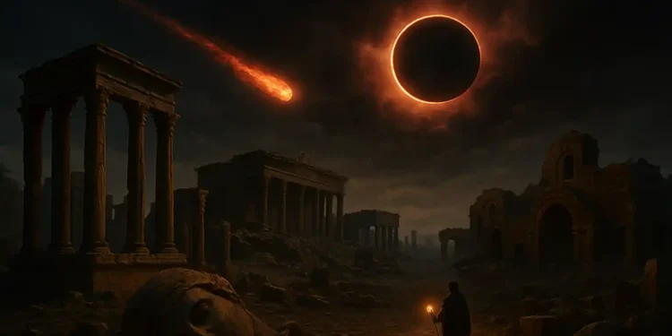
Ancient myths may reveal a forgotten cycle of global cataclysms
Ancient myths may reveal a forgotten cycle of global cataclysms
Instead of isolated folklore, many of these myths may represent fragmented memories of real events that occurred long before modern history began.
Around the world, ancient myths describe devastating events—floods, fire from the sky, days of darkness, and the collapse of entire civilizations. These stories have often been treated as fiction or metaphor. But what if they preserve clues about a forgotten cycle of global cataclysms?
Instead of isolated folklore, many of these myths may represent fragmented memories of real events that occurred long before modern history began. And instead of being random, those events may have followed patterns. Some researchers now argue that we are missing an ancient understanding of how destruction comes not just once, but again and again.
Ancient stories that echo the same warning
Cultures that never interacted still left behind remarkably similar tales. Flood myths exist on every continent. The Epic of Gilgamesh in Mesopotamia, the story of Noah in the Middle East, the legend of Manu in India, and the flood narratives among the Hopi, Maori, and Yoruba people all describe overwhelming deluges that erased earlier worlds.
These are not tales of heavy rain or local disasters. They describe oceans rising over mountains, entire lands disappearing, and only a handful of survivors rebuilding what was lost.
Many traditions also speak of fire from the sky. Norse mythology ends in flames. Zoroastrian teachings include a world-cleansing fire. The Aztecs believed one of their previous suns ended in flames. Some Aboriginal Australian stories describe stars falling and setting the land alight.
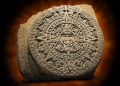
A close-up image of the Aztec sunstone. Shutterstock.
Darkness is another common thread. Egyptian texts mention days without sunlight. Hindu scriptures speak of an age of darkness, Kali Yuga. The Bible refers to the sun being darkened. In Mesoamerican myth, some world ages ended in a darkened sky and the absence of light.
These themes—water, fire, and darkness—are found across ancient myth, separated by geography and language. The repetition suggests more than coincidence. It hints at cultural memory of a forgotten cycle of global cataclysms.
Not linear, but cyclical time
Ancient civilizations did not always see time the way modern cultures do. Today we think in terms of progress and linear development. But in many ancient traditions, time moves in great cycles, each ending in destruction before renewal.
In Hindu cosmology, the Yuga cycle describes four ages. Each age sees a decline in morality and order, ending with devastation before the return of the golden age. According to some interpretations, we are nearing the end of Kali Yuga, the darkest phase.
The Aztecs described five previous suns, each representing a world age. Four have ended in catastrophe. The fifth, our current age, is believed to end with earthquakes.
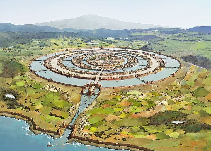
An artists rendering of what Atlantis may have looked like in the past.
Plato described a lost civilization—Atlantis—that fell in a single night of floods and earthquakes. He claimed this was not unique but part of recurring global resets known to Egyptian priests. He spoke of time as containing repeated “cataclysms” that wiped clean the memory of humanity.
These ideas all reflect an awareness of a forgotten cycle of global cataclysms. Civilizations were seen not as permanent, but as vulnerable to periodic collapse.
Earth’s long rhythms and forgotten science
Some researchers believe these myths preserve real events—possibly triggered by natural cycles we’ve only recently begun to understand.
One of these is Earth’s axial precession, a 26,000-year wobble that shifts the position of stars in the sky over time. Some ancient sites, like the Sphinx and Stonehenge, appear to align with stars in ways that match not the present sky, but the sky of ancient epochs. This has led to speculation that ancient cultures were tracking time on cosmic scales.
Another candidate is cosmic impact. The Younger Dryas Impact Hypothesis suggests that around 12,800 years ago, a fragmented comet struck Earth, causing sudden cooling, mass extinctions, and enormous fires across North America. This timing aligns closely with many flood myths and with the end of advanced prehistoric cultures like the Clovis.
An artistic illustration of a comet impact. Did fragments of a comet hit Earth 12,000 years ago? Depositphotos.
Even solar activity might play a role. Some traditions describe the sun behaving strangely—growing dark, changing color, or acting violently. These could be ancient observations of solar flares, magnetic disruptions, or atmospheric changes following comet impacts.
While mainstream science debates these theories, the ancient stories do not shy away from describing worldwide destruction. The key question is whether they are describing fiction—or a pattern we have forgotten.
Myth as encoded memory
Writers like Graham Hancock, Randall Carlson, and others have popularized the idea that myths are not superstition, but information preserved through symbolism and story. They argue that ancient structures, oral traditions, and ritual calendars were part of a global system meant to remember past cataclysms. One example according to some authors is Göbekli Tepe.
Many ancient monuments are aligned with stars, solstices, or equinoxes. Some appear to be maps of the sky or calendars tracking long cycles. Petroglyphs and sacred texts often describe disasters in symbolic terms—dragons, floods, heavenly fire—that may represent real events experienced by ancient people.
While these theories are controversial, they force us to ask difficult questions. Why do myths around the world describe similar events? Why do so many refer to a world before the current one? And why were ancient people so focused on preserving this knowledge?
Perhaps they were trying to pass on more than culture. Perhaps they were trying to warn us.
A message for the present age
Modern life feels stable—until it doesn’t. Earthquakes, volcanoes, solar flares, asteroid near-misses, and rapid climate shifts all remind us how fragile civilization really is.
The ancient world may have known this better than we do. Their stories speak not only of disaster but of recovery. The survivors of the last cycle built again. They told their children. They carved the warnings into stone.
Maybe myths are more than imagination. Maybe they are fragments of a survival manual.
The forgotten cycle of global cataclysms might not be a relic of the past. It might be a reality we are part of, one we no longer see because we stopped looking. The ancient world remembered. The question is whether we are still capable of doing the same.
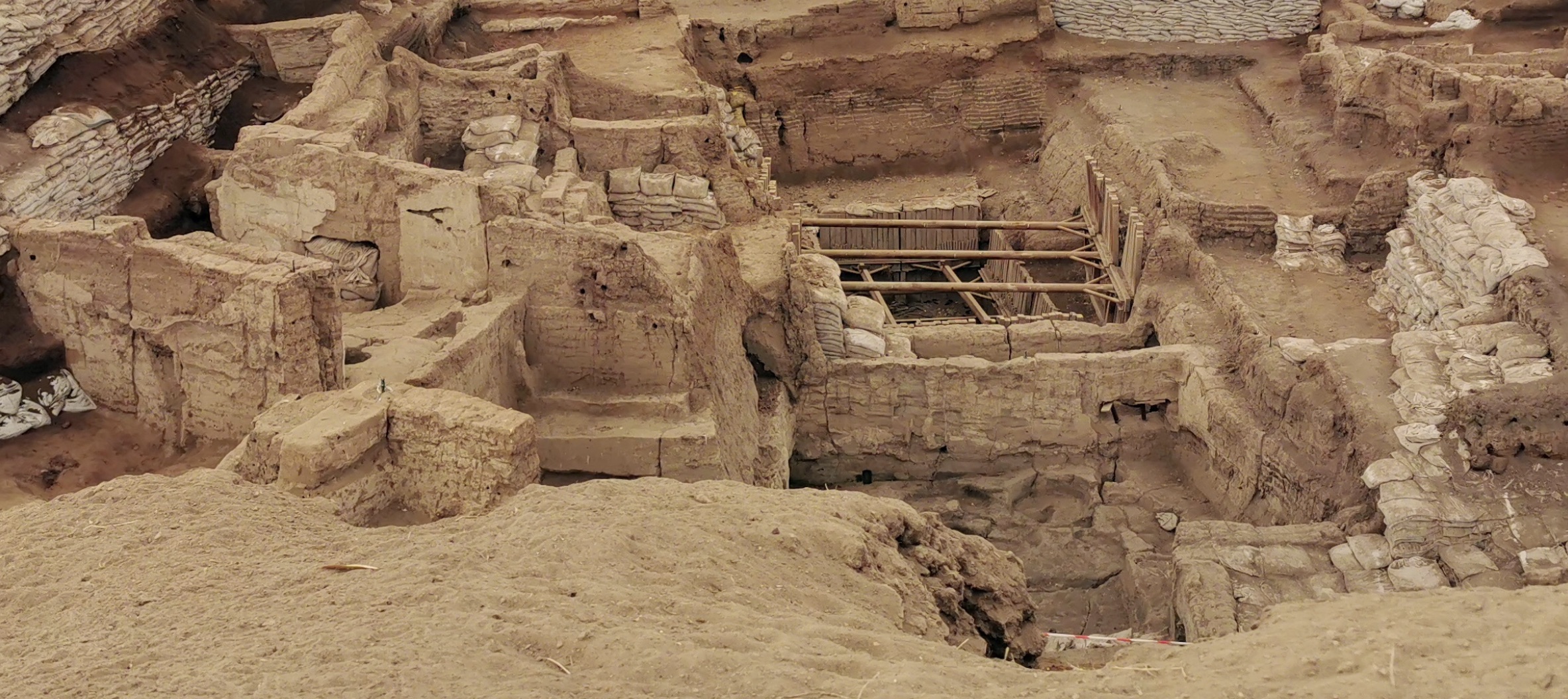
Why were so many ancient cities built on top of each other?
Why were so many ancient cities built on top of each other?
Cities usually grow outward. But some grew upward — not from ambition, but from memory. Across the ancient world, entire civilizations were built one layer at a time, not by accident, but through centuries of people refusing to leave the ground they called home.
Beneath the streets of Aleppo, under the hills of Turkey, and across the plains of Mesopotamia lie the bones of cities long gone. Not buried by nature always, sometimes by choice. Sometimes layered on purpose. These are places where people didn’t just return to rebuild after collapse — they stayed put and built again, directly on top of the past.
The phenomenon of ancient cities built on top of each other is not a quirk of history. It is one of the most consistent and revealing patterns in the archaeology of early civilization. At sites like Çatalhöyük, Tell Brak, and Jericho, we find stacked layers of mudbrick, ash, and stone that represent thousands of years of unbroken occupation. When I look back at these, I kind of feel that every layer tells a story. And it is not just one of progress, but one of survival, one of adaptation, and the human instinct to stay grounded in place.
But before I go any further, I would like to take a moment to explain the words “tell,” “tepe,” and “tappeh”.
What do “tell,” “tepe,” and “tappeh” mean?
If you’ve ever come across names like Tell Brak, Göbekli Tepe, or Tappeh Sialk, you might have wondered what those words mean. So, they’re not just names. They’re clues about the history hidden beneath the surface.
In archaeology, a “tell” is an artificial mound formed by layers of human settlement built up over time. The word tell comes from Arabic and means “hill.” These mounds form when people live in the same place for hundreds or even thousands of years. Each time a building collapses or burns down, the debris stays behind. New buildings go up right on top. Over time, the site rises higher and higher, creating a mound filled with history.
The massive pillars at Göbekli Tepe. Image Credit: Wikimedia Commons.
In Turkish, the same kind of mound is called a “tepe,” which also means “hill.” That’s why we see names like Göbekli Tepe in modern-day Turkey. The name literally translates to “Potbelly Hill.”
In Persian (Farsi), the word is “tappeh.” In Iran, many ancient sites use this term, like Tappeh Sialk or Tappeh Hesar. Just like tells and tepes, these are mounds formed from ancient cities that were built, destroyed, and rebuilt over and over again.
So while the words are different, they all point to the same idea. Whether it’s a tell, tepe, or tappeh, it means you’re looking at a place where people stayed for a long time, rebuilding their homes on the same ground again and again. And underneath each one lies layer after layer of forgotten history.
Why did people rebuild in the same place?
I will try and explain this the best way I can so it makese sense.
But before we start I would like to clear somehing: rebuilding on top of older ruins wasn’t just about tradition. It made practical sense for a lot of reasons, and those reasons were often tied to survival.
First, there was the need for water. Fresh sources like rivers, springs, and wells didn’t move. If a site had good access to water, people would come back to it again and again. In dry regions, staying close to reliable water could mean the difference between life and death.
Then there was the value of fertile land. Soil that could support crops wasn’t available everywhere. Once people learned how to work the land in a specific place, it made sense to stay there. Moving away could mean losing hard-earned knowledge about how to survive in that environment.
Geography also played a role. Many early cities were built on hills or near mountain passes, where they had a better view of the surrounding area and could defend themselves more easily. Others were near trade routes, allowing them to control movement and commerce. Giving up those positions would have been a big loss.
Materials mattered too. Building supplies like stone, timber, and mudbrick were valuable and not always easy to find. After a disaster — whether from war, fire, or time — people often reused whatever they could. Rebuilding on the same ground saved effort and made use of what was already there.
Finally, there was a deep sense of connection to place. People returned to where they had grown up, where their ancestors were buried, where stories had been passed down. These locations held emotional weight. Staying put wasn’t just practical. It helped people hold on to who they were.
Çatalhöyük: Where life and memory were stacked in mudbrick
Catalhoyuk is considered one of the earliest known cities on Earth.
Without a doubt, one of my favorites.
In the heart of what is now central Turkey lies one of the earliest known cities in human history — Çatalhöyük. First settled around 7500 BCE, this Neolithic site grew into a dense community of thousands. What makes it so fascinating isn’t just its age, but how it was built and rebuilt over time.
People at Çatalhöyük lived in tightly packed mudbrick houses. Instead of streets, they walked along rooftops, entering their homes through holes in the ceiling using ladders. When a house was abandoned or collapsed, a new one was constructed directly on top of the old foundation. Over the span of about 1,200 years, this cycle created 18 layers of construction, stacked one above the other.
The layers weren’t just architectural. They were deeply personal. Families buried their dead beneath the floors of their homes. That meant every new house was also resting on the memory of those who had lived there before. Çatalhöyük was more than a city. I feel it was a place where memory, ancestry, and everyday life were physically tied together. Layer across layer.
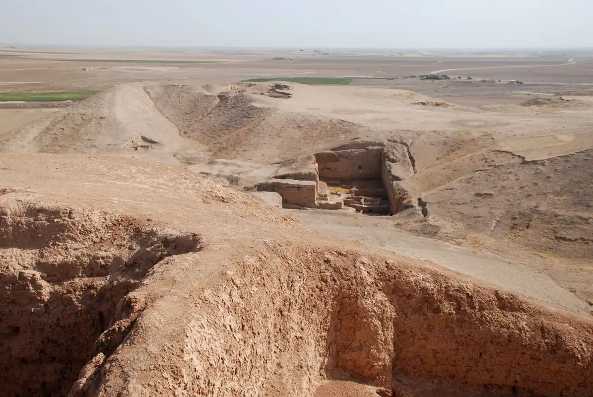
Tell Brak: A city that grew from a sacred center
General_view_of_Tell_Brak
Over in northeastern Syria stands Tell Brak, another key to understanding the layered nature of ancient cities. It began as a small settlement around 6000 BCE, but over time, it developed into one of the first large urban centers in the world.
Its early structures were likely ceremonial — shrines and sacred enclosures that marked the site as spiritually important. As the population grew, homes, administrative buildings, and roads began to form around these sacred spaces. And like at Çatalhöyük, the site was rebuilt again and again as each generation adapted to new conditions.
Some of Tell Brak’s layers are thin, representing short-term activity. Others are deeper, the result of longer, more stable phases of occupation. What holds it all together is continuity. Despite changes in leadership, culture, and environment, people kept coming back. They didn’t abandon the place when things got hard. They built over it and moved forward.
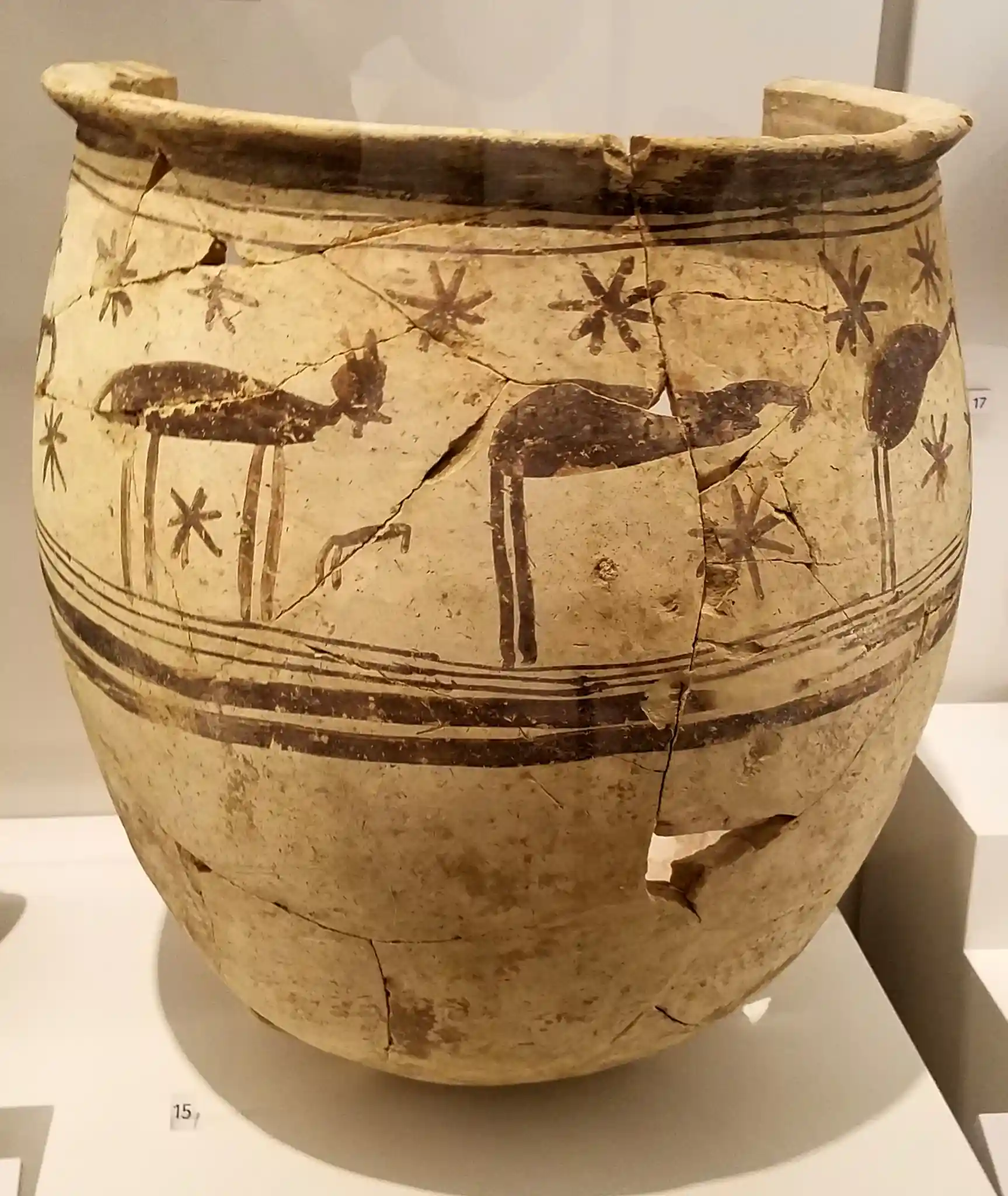
Tepe Gawra: Sacred patterns that never faded
A storage jar from Tepe Gawra. Credit: Wikimedia Commons.
North of Mosul in modern-day Iraq lies Tepe Gawra, a site known not just for its long history, but for how that history was shaped by religious life.
Tepe Gawra was occupied from about 5000 BCE and contains 16 layers of construction. As temples fell out of use, new ones were often built on top of them. In some cases, the exact layout was preserved, even as decorative elements or materials changed. This suggests more than just practicality. It points to a deep respect for sacred space.
Generations of people reused the same ground to worship, plan, and gather. The buildings changed, but the meaning behind them did not. Tepe Gawra shows how spiritual identity was literally rooted in place.
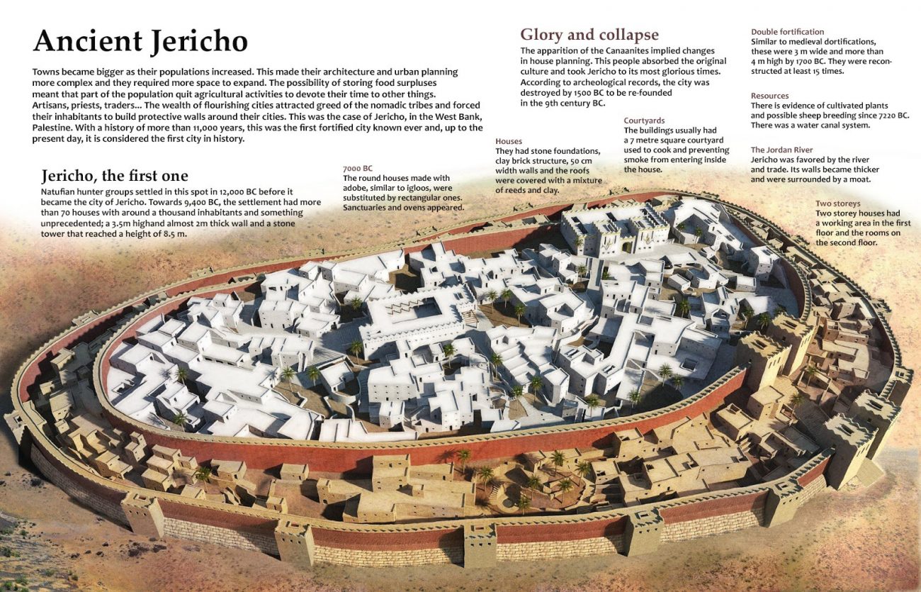
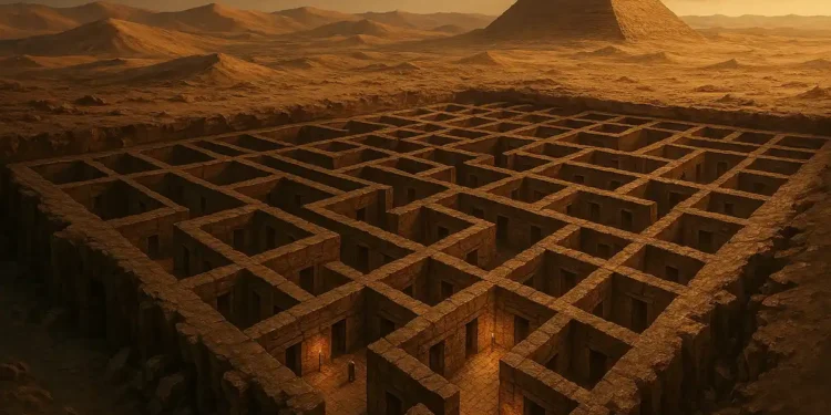
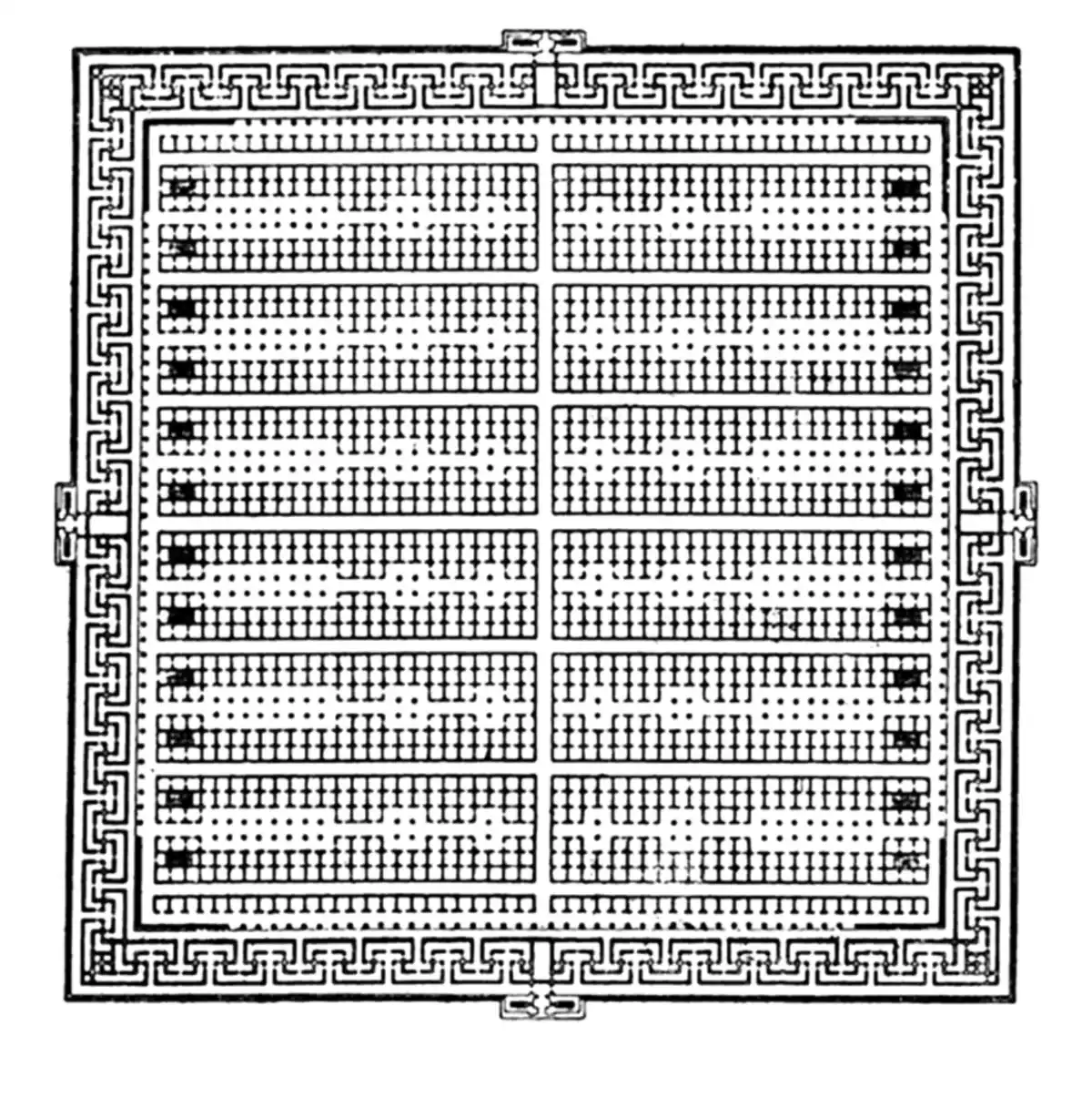
Jericho: A city layered with 11,000 years of survival
A map of the ancient city of Jericho.
Few places on Earth have been occupied as long as Jericho. Located near the Jordan River, it is one of the oldest continually inhabited cities in the world. Excavations at Tell es-Sultan, the ancient core of Jericho, reveal more than 20 layers of human settlement dating back to around 9000 BCE.
One of the most striking finds is a massive stone tower and wall system that dates to the Neolithic era, long before similar structures appeared elsewhere. As each civilization passed through, it built on top of what came before. Homes, fortifications, and tools from different ages now lie stacked in the soil, preserved in a vertical record of resilience.
Jericho isn’t just a story about one people or one culture. It’s a case study in continuity. Despite conquest, natural disaster, and political change, the city remained. The location mattered more than the name or ruler of the day.
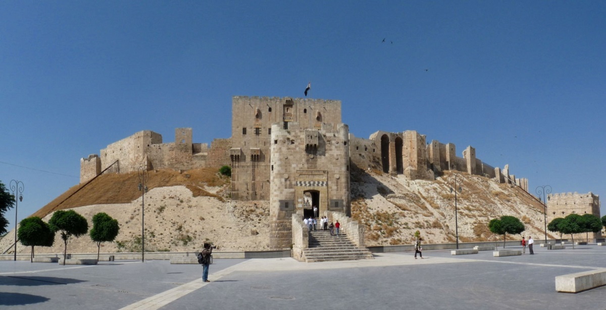
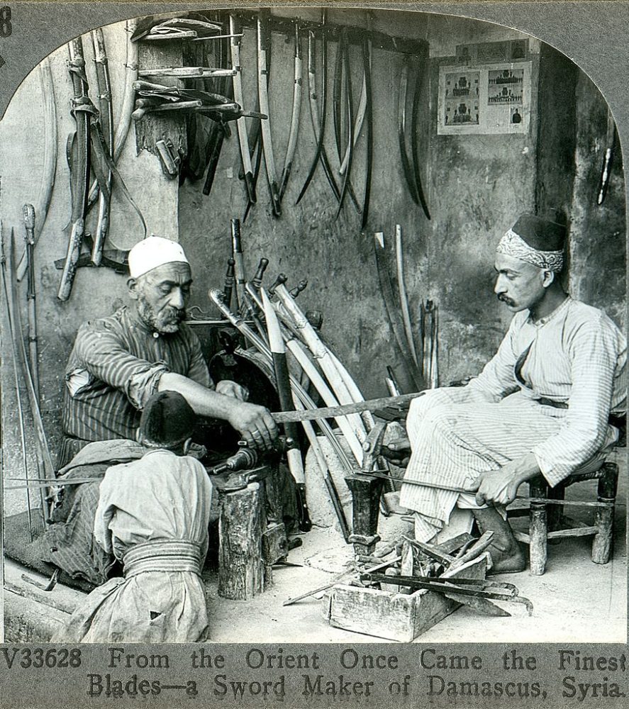
Aleppo and Damascus: Where history still breathes beneath the surface
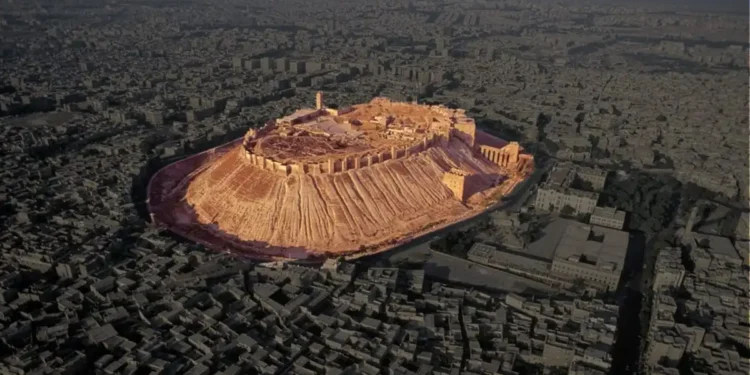
Frontal view on the Citadel of Aleppo. Image Credit: Wikimedia Commons.
Some ancient cities are still very much alive. Aleppo and Damascus, both located in Syria, are among the world’s oldest continuously inhabited cities. Unlike Çatalhöyük or Tell Brak, these are not archaeological sites frozen in time. They are living, breathing places where people still go to work, shop in markets, and pray in centuries-old mosques.
But beneath those streets lie the buried remains of Bronze Age buildings, Roman roads, and medieval fortifications. Excavations are difficult because life continues above them. Still, what’s already been uncovered tells a clear story: layer after layer, civilization after civilization, all built in the same place.
In cities like Aleppo and Damascus, I dont see the past as being buried and forgotten. I see it built into the streets and buildings people still use today. The layering never really stopped.
Staying in place wasn’t always a choice. Sometimes, it was the only option.
So what do we learn from the amazing examples above? Not every ancient city was rebuilt because people wanted to keep a tradition alive. Sometimes they stayed because the ground still gave them what they needed. There was a spring nearby. Or the fields still produced grain. Or the road still led to trade.
But other times, they stayed because the land had become part of who they were. The memory of ancestors, rituals, and buried homes gave the place weight. Walking away would have meant walking away from everything that gave their lives shape.
That’s why we find temples built over older temples. Streets rebuilt along the same lines. City walls rising again where they once fell. In other words, this wasn’t nostalgia. It was actually a way to keep going while staying grounded in what came before.
Photograph from 1900 showing a bladesmith from Damascus. Credit: Wikimedia Commons
Technology is now catching up to what was always there
We’ve known for centuries that cities were built on older cities. But only recently have we started to understand just how many layers are hidden beneath the surface, and how much we’ve missed by only looking at what we can see.
With ground-penetrating radar, LIDAR, and other tools, archaeologists are finding older foundations below familiar sites. What we thought was the beginning turns out to be the middle. Cities like Troy and Uruk have become deeper, both in time and meaning, thanks to what these tools reveal. But LiDAR has made some amazing discoveries in the Amazn rainforest as well, where it practically discovered traces of a long-lost civilization whose traces were buried beneath dense layers of vegetation.
What I also find extremly intersting and peculiar is that in places like Jericho or Damascus, the remains of dozens of earlier settlements lie just below modern streets. They’re not ruins in a museum. They’re still part of the living city, buried but not gone.
Every time a shovel hits stone in these places, it brings up more than debris. It brings up decisions of the ancestors. To rebuild. To stay. To remember. And thats kind of what Zahi Hawass told me during one of my podcasts when I asked him about Giza, and how much “stuff” was still buried beneath the surface there. He replied saying that if you were to excavate in present-day Giza, youd likley come up with an item of two of the ancient Egyptian civilization. And I guess this applies to other sites across the world.
How Were the Pyramids Built? Engineers Suggest a New Theory
How Were the Pyramids Built? Engineers Suggest a New Theory
Story byTheo Burman
The pyramids may have been built using a sophisticated hydraulic system, according to a new study in Egypt.
Evidence of ancient Egyptians using water pressure to lift stone blocks was discovered at the Step Pyramid of Djoser, with a research team concluding its architecture matched that of a "hydraulic elevation mechanism."
Why It Matters
The theory could be the earliest evidence of hydraulic engineering in monumental architecture, and provides an explanation of how the pyramids were erected with tools previously thought unavailable at the time. If correct, it means that the Egyptians had a far greater understanding of hydraulic technology than previously thought.
What To Know
Most mainstream theories propose that the Egyptians used ramps and brute manpower as the primary methods for lifting the limestone blocks that make up the pyramids.
However, the study argues that the internal layout of the Step Pyramid, combined with the surrounding landscape, suggests that engineers may have used a volcano-style mechanism in which water-driven pressure helped elevate stones from within the structure.
The system would have operated in tandem with natural topography and artificially created reservoirs, potentially linking to a tributary of the Nile to create a temporary lake.
Stock Image: General view of the Step Pyramid of Djoser at Saqqara on February 9, 2024 in Giza, Egypt.
The main pieces of evidence supporting the hydraulic theory were the discovery of a "dry moat" surrounding the pyramid, as well as a massive stone structure known as the Gisr el-Mudir. These features resemble components of a modern water treatment system, including sedimentation and purification basins.
The Gisr el-Mudir could have functioned as a check dam to trap and regulate water flow, which in turn could have powered the lifting mechanism inside the pyramid. However, this setup implies a level of hydraulic sophistication way beyond all prior assumptions about how advanced ancient Egyptian engineering was.
What People Are Saying
In the abstract of the report, the researchers said: "The Step Pyramid of Djoser in Saqqâra, Egypt, is considered the oldest of the seven monumental pyramids built about 4,500 years ago. From transdisciplinary analysis, it was discovered that a hydraulic lift may have been used to build the pyramid.
"Based on our mapping of the nearby watersheds, we show that one of the unexplained massive Saqqâra structures, the Gisr el-Mudir enclosure, has the features of a check dam with the intent to trap sediment and water.
"The ancient architects may have raised the stones from the pyramid centre in a volcano fashion using the sediment-free water from the Dry Moat's south section. Ancient Egyptians are famous for their pioneering and mastery of hydraulics through canals for irrigation purposes and barges to transport huge stones."
What Happens Next
Researchers continue to investigate how the pyramids were built, with more focus being put into the possibility of hydraulic power.
The oldest structures on Earth were built before history began — And they don’t match the history books
The oldest structures on Earth were built before history began — And they don’t match the history books
Before cities or writing, ancient builders carved massive stone sites with cosmic precision. Some are over 10,000 years old—and they don’t match the history books.
Long before the birth of cities, kings, or written language, someone was carving monuments out of stone with uncanny precision. These weren’t simple shelters or scattered rocks. They were massive, organized, astronomically aligned structures—built by hands we still don’t understand. And in many cases, long before we were supposed to be capable of building anything at all. In this article, I will take you across some of the oldest structures on Earth.
What we’ve found at sites like Göbekli Tepe, Karahantepe, Nabta Playa, Gunung Padang, and the deepest layers of Baalbek doesn’t align with the timeline printed in textbooks. If the dates are correct—and mounting evidence suggests they are—then our timeline of civilization is off by thousands of years. Despite this overwhelming evidence, history is not being corrected or updated. We continue to tach the same outdated information in school. Despite physical evidence that suggests that history as we know it is far more complex than what we believed only a couple o decades ago. In this article, I will take you across some of my favorite ancient sites and explain why they don’t match history as we are being told.
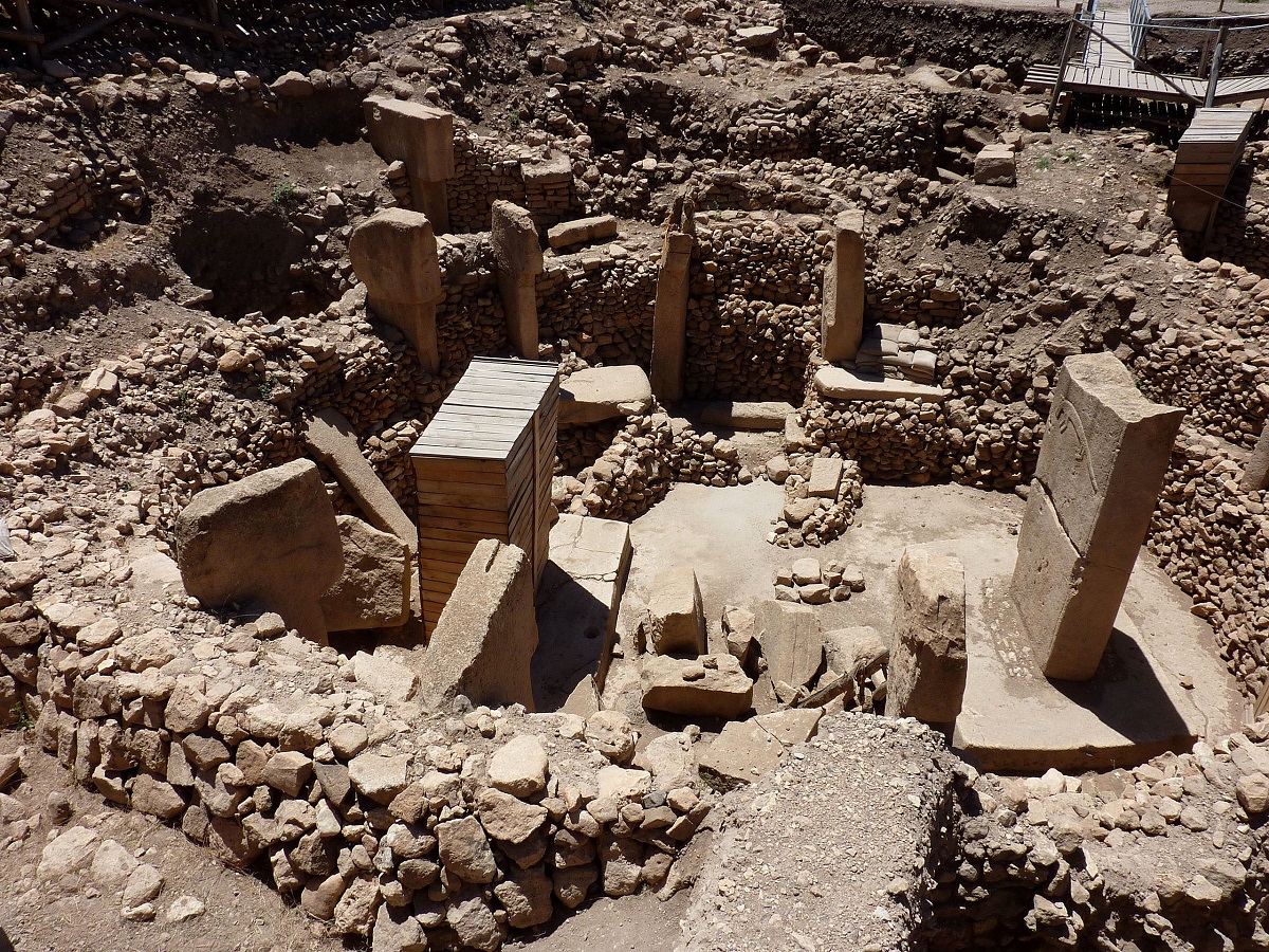
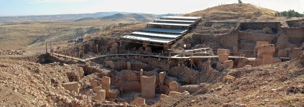
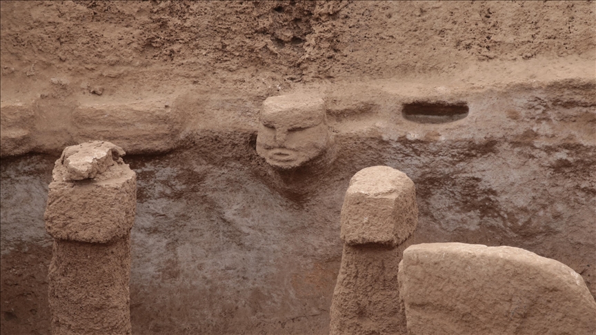
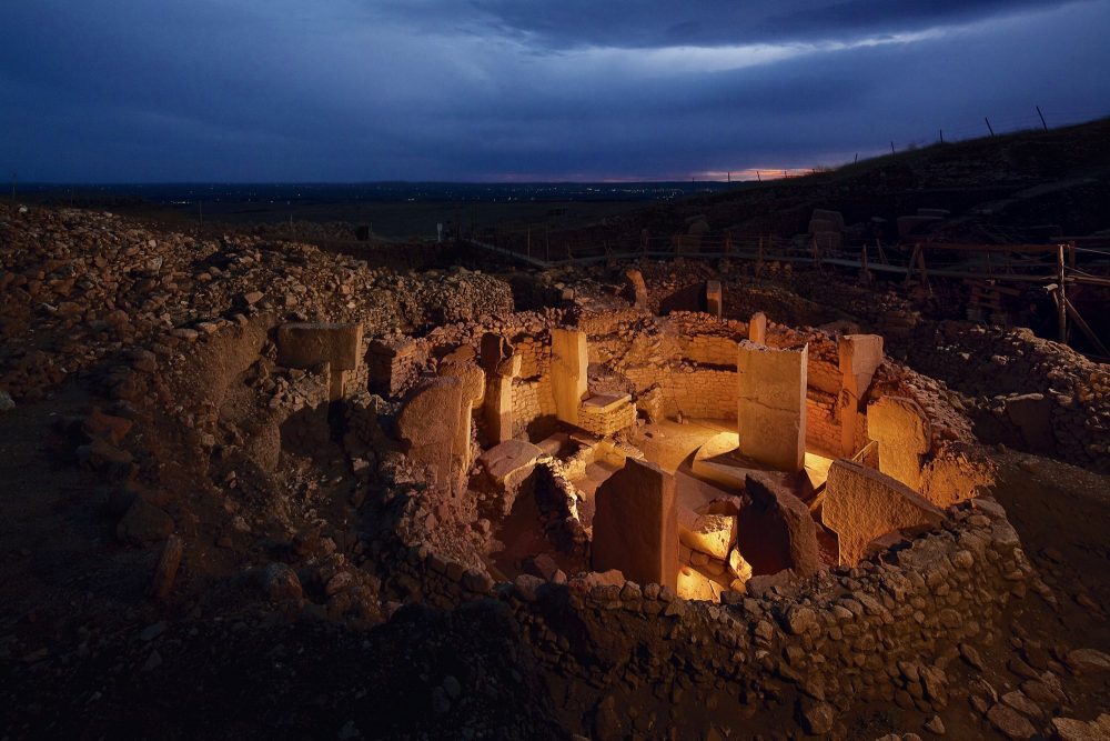
Göbekli Tepe Was Buried on Purpose—But Why?
A view of the megalithic stones at Göbekli Tepe. Most of the site still remains buried beneath the surface. 7Image Credit: Wikimedia Commons.
Tthis is, I think, one of my favorite ancient sites and literally one of the oldest strcutres on Earth, and I have written about it on various oacacions where I have outlined why this site is such a history breaker. Tucked beneath a dusty hill in southeastern Turkey, Göbekli Tepe stunned the archaeological world when it was first excavated in the 1990s. Carbon dating placed the site at least 11,500 years old, making it not only older than the pyramids, but older than agriculture, pottery, or any form of writing.
Carved T-shaped megaliths, each weighing up to 20 tons, stand in circular formations. They’re decorated with reliefs of wild animals, abstract symbols, and possibly mythological beings. The stonework is not rough or experimental—it’s precise. Intentional. Studies have demonstrated that he builders of this ancient site used advanced geometrical reasoning. And then there’s the strangest part: the entire complex was deliberately buried in antiquity. Someone not only built it—they entombed it. No one knows why.
What purpose did it serve? A temple? A place of ritual gathering? A sky-watching observatory? Nothing about Göbekli Tepe fits the narrative of primitive nomads just learning how to sow seeds. Tis site breaks history because sites like it should not have been possible according to mainstream experts. Yet there it is. Göbekli Tepe is truly a history changer and not many people know about it.
Karahantepe Adds Depth—Literally and Figuratively one of the Oldest Strcutures on Earth
Human depictions and 3D sculptures in the 11,000-year-old Karahantepe complex. Credit: Anadolu Agency
And a short distance away from Göbekli Tepe we have another shocker.
Just 35 kilometers from Göbekli Tepe lies Karahantepe, a site of the same age that may be even more complex. Unlike Göbekli’s open-air circles, Karahantepe includes deep, carved chambers—entire rooms built into the bedrock. More than 250 stone pillars have been uncovered so far, along with stylized human heads and abstract sculptures embedded in the walls. Who could have built these gigantic strcutres over 11,000 years ago? Where they really hunter-gatherers as mainstream experts suggest, or is there something more complex about these ancient people?
The complexity and site of this site was not a one-off anomaly. I believe that whoever built Göbekli Tepe was part of a broader cultural world—possibly a network of sacred or ceremonial sites. Karahantepe expands the story, suggesting the region was teeming with early symbolic architecture. And yet, just like Göbekli, it appears and disappears with no clear lineage, no gradual development, and no evolutionary trail. It’s as if it came from nowhere.
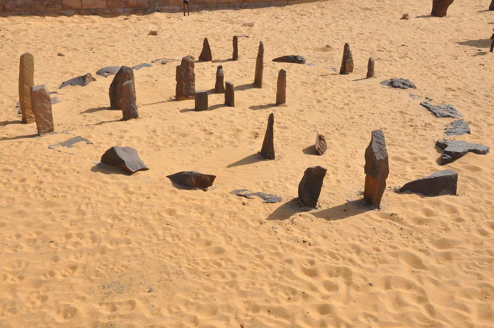
Nabta Playa May Have Tracked the Stars Before Egypt Had a Name
This is what some of the stone cricles of Nabta Playa look like. Reddit.
We cannot go through an article mentioning the oldest structures on Earth without mentioning this incredible acient site. In the Nubian Desert of southern Egypt, Nabta Playa looks at first like a scatter of rocks in the sand. But its alignment tells another story. Dating back 7,000 to 9,000 years, the stones were arranged to mark the rising of Sirius, the brightest star in the night sky—an event that would later become central to Egyptian calendar systems.
Long before pharaohs, this site may have served as both a ceremonial ground and a celestial clock. Buried cattle remains suggest ritual sacrifice, possibly tied to early pastoralist religion. This hints at a connection between astronomy, myth, and seasonal survival long before formal religion or kingdoms took shape. Though smaller in scale than Göbekli or Karahantepe, Nabta Playa reveals something similar: a deep concern with time, sky, and cosmic order. All from people we call “prehistoric.”
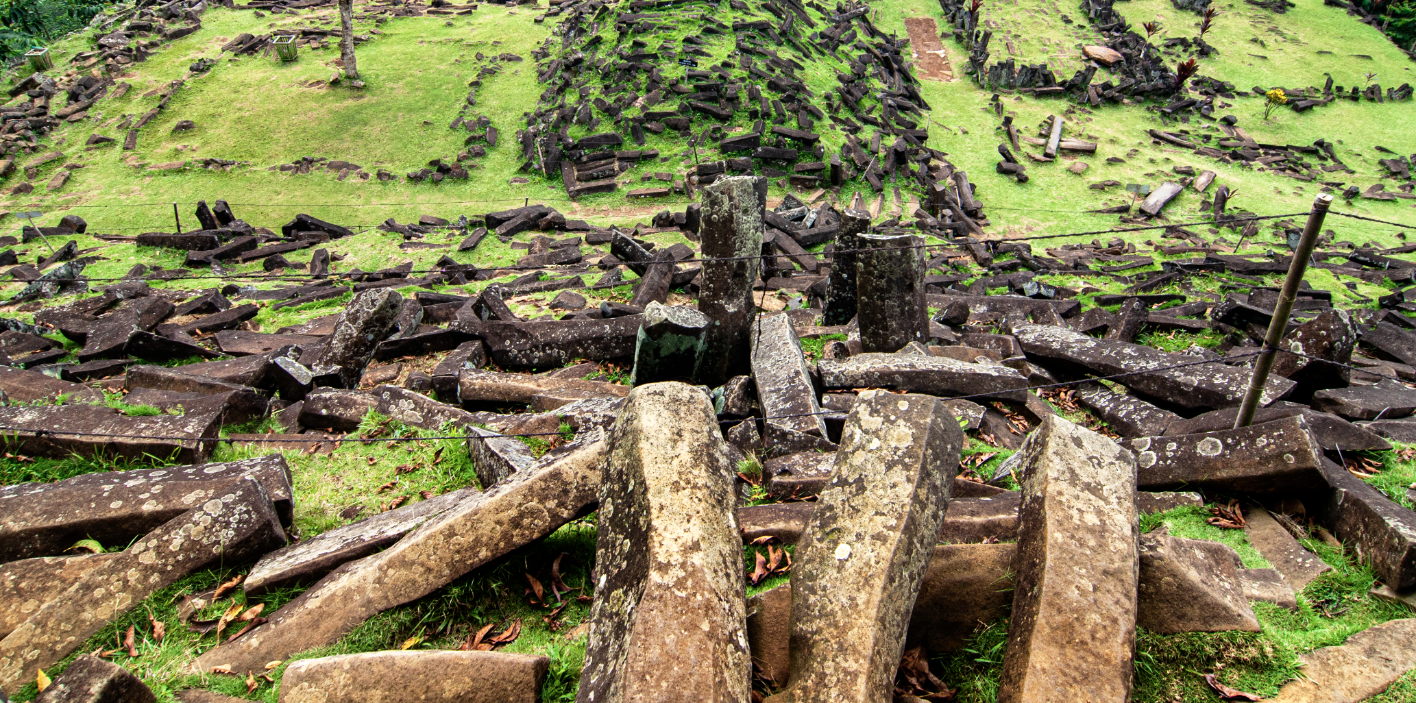
Gunung Padang Could Be the Oldest of Them All
The top of Gunung Padang. This ancient site is one of the most controversial. Credit: Wikimedia Commons.
Indonesia’s Gunung Padang might be the most controversial site on this list—but it could also be the most astonishing. On the surface, it looks like a stepped hill made of volcanic stone. But excavations in the last decade have revealed terraces, chambers, and layers of construction that extend 20 meters deep. Some geologists argue the deepest layers could date to as early as 20,000 BCE—a time when the Earth was still in the grip of the last Ice Age.
If proven true, it would be the oldest known human-built structure on Earth by a wide margin. But mainstream archaeologists remain skeptical. The core question is whether the deeper layers are artificial or natural. The debate is ongoing. Regardless of the final verdict, the site challenges our assumptions. At the very least, it shows human activity at the site far earlier than previously believed. At most, it suggests a lost chapter of human development buried—literally—beneath layers of time and earth.
Baalbek’s Megastones Hint at a Forgotten Foundation
Another one of my favorite sites.
High in the Bekaa Valley of Lebanon, the ruins of Baalbek are often credited to the Romans, who built temples to Jupiter and Bacchus atop its massive stone platform. But beneath those classical columns lies a deeper mystery—one that predates Roman engineering by millennia. At the heart of the platform are the Trilithon stones: three limestone blocks each weighing over 800 tons. Nearby, an unfinished stone known as the Stone of the Pregnant Woman weighs more than 1,000 tons. Even with today’s technology, moving and placing these megaliths would be a challenge.
No one knows how they were transported, lifted, or aligned with such precision—and the builders left no inscriptions, no clear cultural fingerprints. Some researchers argue the deepest layers of Baalbek’s foundation could stretch back to the pre-pottery Neolithic, possibly linked to the same horizon as Göbekli Tepe and Karahantepe. If that’s true, then Roman temples were built atop something far older—a platform whose origins remain undocumented. Baalbek’s base may not yet be as precisely dated as the others on this list, but it raises the same unsettling question: Who built the foundation—and when?
Why Were They Building at All?
This is the question that lingers. Why were people with no cities, no writing, no metallurgy, and supposedly no organizational complexity carving massive stones and aligning them to the stars? Some researchers believe these were spiritual centers. Others think they were calendars—designed to track the solstices, lunar cycles, or stellar movements crucial to seasonal survival. Still others suggest they were gathering places where ideas, stories, and collective memory were shared in symbolic form.
But here’s the problem: none of this fits with how we define “prehistory.” We were taught that humans built monuments after developing agriculture and complex societies. These sites flip that script. Maybe, just maybe, the desire to build came first—and everything else followed.
If even one of these sites is as old as the evidence suggests, then the timeline of human history needs serious revision. The builders were capable of organizing labor, understanding celestial cycles, and shaping stone on a massive scale. These weren’t scattered efforts. They show patterns — of intent, of knowledge, and of memory we no longer share. There’s still too much we don’t know. But it’s clear we’ve been starting the story too late.
Did lost civilizations before history vanish in a forgotten global disaster?
Did lost civilizations before history vanish in a forgotten global disaster?
Did lost civilizations before history disappear in a global catastrophe? From sunken cities to ancient monuments, new clues suggest we’ve barely scratched the surface.
The official story of human civilization begins around 6,000 years ago, with the rise of early city-states in Mesopotamia and Egypt. But new discoveries are challenging that timeline. What if we’ve overlooked an entire chapter—an era of lost civilizations before history, wiped out by a global catastrophe and forgotten beneath layers of earth, myth, and rising seas?
The mysterious climate crash that changed everything
Roughly 12,800 years ago, the Earth experienced a sudden, violent cooling event known as the Younger Dryas. Within decades, global temperatures dropped, megafauna went extinct, and entire ecosystems unraveled. No one knows exactly what caused it.
One of the most controversial theories—the Younger Dryas Impact Hypothesis—suggests that fragments of a massive comet struck Earth, triggering wildfires, floods, and atmospheric collapse. If such an impact occurred, it could have erased entire cultures in one swift blow.
But is there any trace of what may have existed before that disaster?
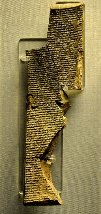
Gobekli Tepe is, by far, the oldest temple in the world and apparently, it is connected to a massive comet impact from around 13,000 years ago.
The discovery of Göbekli Tepe in southeastern Turkey stunned archaeologists. This is wihtout a doubt one of my favorite sites, for many reasons. Dated to around 9600 BCE, it predates Stonehenge and the pyramids by millennia. Its massive stone pillars, many over 5 meters tall and weighing up to 20 tons, were arranged in circular enclosures—carved with animals and symbols whose meanings are still unknown.
And yet, Göbekli Tepe is not alone.
Karahan Tepe (Turkey), just 35 km away, is even older and features human-like statues and T-shaped pillars similar in style.
Nevalı Çori, buried under a modern dam, showed early megalithic architecture from around 8500 BCE.
Wadi Faynan (Jordan) and Ain Ghazal (Amman), both Neolithic sites, reveal complex social structures and large-scale building from 8500–7500 BCE.
Tassili n’Ajjer (Algeria), though harder to date precisely, holds cave paintings of beings in strange suits, possibly over 10,000 years old.
These discoveries raise a serious question: How did people with no known agriculture or writing build such monuments? Did they inherit knowledge from an earlier culture—one wiped clean from the record?
Cities beneath the sea
During the last Ice Age, sea levels were more than 100 meters lower than today. As the glaciers melted, coastlines vanished. Much of humanity’s early settlements—always near water—would now lie submerged, often beyond reach of standard archaeological tools.
And yet, some of them have been found.
Dwarka, off the coast of India, is an underwater city with stone walls, grids, and anchors, dated by some researchers to at least 7500 BCE.
Pavlopetri (Greece), a sunken Bronze Age city, features streets, buildings, and a central square—submerged around 1000 BCE, but possibly older.
Atlit Yam (Israel), buried beneath the Mediterranean, contains stone houses, graves, and a stone circle—dated to 7000 BCE.
These cities suggest an entire world of early human habitation may now lie underwater—unmapped, unstudied, and forgotten. We know more about the surface of Mars then the surface of our oceans. And that is a fact.
Gaps too large to ignore
Archaeology is often focused on what can be confirmed. But it’s the missing pieces that tell another story. There is a gap of thousands of years between the Ice Age and the rise of “official” civilizations like Sumer and Egypt. Yet in that gap, we find stunning stonework, monumental architecture, and sudden cultural shifts.
Even the Sphinx at Giza has been reexamined by some geologists, who point to weathering patterns consistent with heavy rainfall—rain that Egypt hasn’t seen since at least 7000 BCE. Of course this is a massive controversy and this timeline is not acepted in mainstream science.
If these structures predate what we call history, who built them?
Are myths memory?
Ancient cultures from every corner of the world carry stories of floods, sunken lands, and golden ages lost to time. The Greeks had Atlantis. The Hindus speak of long cycles of destruction and rebirth. The Sumerians recorded kings reigning for thousands of years before the flood.
For decades, such stories were dismissed as metaphor. But as more evidence comes to light, researchers are beginning to ask: Were these myths rooted in real events—the fading memories of a civilization that fell beneath the waves?
The future of the past
Advances in LIDAR scanning, satellite imagery, and underwater exploration are rapidly transforming our view of the past. New sites are being discovered in the Amazon, under jungles in Cambodia, and possibly even beneath the sands of Egypt.
As our tools improve, so do the odds of finding proof—of cities that came before, of cultures lost to sea and flame, and of a history far deeper than textbooks allow.
What if we’re the second or third version of civilization?
What if everything we’ve built rests on the bones of a world we’ve already lost? The clues are mounting—and the silence between them might be the loudest signal of all. Did lost civilizations before history disappear in a global catastrophe? From sunken cities to ancient monuments, new clues suggest we’ve barely scratched the surface. And what if we are just a second or ever thrid version of civilization. But more on that, in a different article.
Shocking DNA findings from two mummies discovered in Northern Africa may rewrite the family tree of human history.
Scientists from the Max Planck Institute in Germany found that these ancient corpses unearthed in present-day Libya carried the DNA of a previously unknown group of humans from 7,000 years ago.
This lost group in the Sahara Desert had a distinct genetic makeup that was much different than scientists expected to find out among ancient humans traveling in and out of Africa.
Between 5,000 and 14,500 years ago, this desert region was a lush and fertile area known as the Green Sahara.
That has led scientists to believe that ancient humans in this part of the world would have interacted more with other human tribes arriving from sub-Saharan Africa and the Middle East.
Instead, this lost group appears to have completely isolated themselves from other human populations migrating to the Green Sahara.
In fact, the mummy DNA had significantly less Neanderthal DNA than ancient humans living outside of Africa in that era, challenging what researchers assumed about the ancient world and how much these cultures intermingled.
First author Nada Salem from the Max Planck Institute for Evolutionary Anthropology said: 'Our research challenges previous assumptions about North African population history and highlights the existence of a deeply rooted and long-isolated genetic lineage.'
Scientists have discovered 2 mummies in present-day Libya which appear to be from a long lost lineage of early humans
The skeletons were identified as being from two women, buried in the Takarkori rock shelter in southwestern Libya.
Instead of sharing a similar genetic makeup with modern populations from Africa, the Middle East, and Europe, these women had close genetic ties to a group of scavengers from 15,000 years ago.
The German researchers said these foragers lived in caves in present-day Morocco during the last Ice Age.
Both the group from the Ice Age and the newly discovered mummies from the Green Sahara have a DNA makeup that is completely different from sub-Saharan Africans.
This appears to prove that the two populations on the continent stayed relatively separate, even though this fertile region provided ample opportunity for the communities to meet and eventually interbreed.
In comparison to ancient humans found outside of Africa from 7,000 years ago, the Takarkori mummies have only a small trace of Neandertal DNA - far less than the one to two percent in Middle Eastern farmers of that time period.
Researchers noted that this unique lineage of humans no longer exists in its original form in the modern world.
The DNA of the Takarkori mummies now only makes up a part of the greater genetic puzzle in humans today.
However, the team explained that 'this ancestry is still a central genetic component of present-day North African people, highlighting their unique heritage.'
Scientists from Germany say the 2 female skeletons trace their ancestry back to a population of scavengers from the Ice Age 15,000 years ago
Roughly 7,000 years ago, the Sahara Desert was actually a fertile land that scientists now refer to as the Green Sahara. It was a region that would have been ideal for farming and herding livestock
As for how this changes the story of early human history, the study published in the journal Nature contended that the mummies prove that early agricultural practices spread by one group teaching others how to farm and herd livestock.
This practice, known as cultural diffusion, means that the lost group of humans learned new ideas and shared their own with outsiders, but rarely intermarried or lived together.
Based on this theory, people in the Sahara started herding livestock around 7,000 to 8,000 years ago. Those ideas likely came from ancient travelers making their way from the Middle East.
The Green Sahara's grassy plains and water sources were perfect for grazing animals, so it made sense for people to adopt this lifestyle.
Based on the genetic results of the Takarkori mummies, it's clear that the Middle Eastern farmers did not permanently migrate to this area, according to the study.
This 'migration theory' would have meant that Middle Eastern herders moved into the Green Sahara with their animals, bringing their genes along, and eventually changing the genome of the local population.
However, none of this appears to have taken place, and herding actually spread throughout Northern Africa because it was a practical skill, not part of a cultural takeover.
So Did the Antikythera Mechanism Actually Work? New Research Casts Doubt
The Antikythera Mechanism has long been hailed as a marvel of ancient technology, frequently referred to as the world’s first analog computer. But despite decades of study and technological advancements in imaging and simulation, its exact purpose and level of precision remain a subject of considerable debate. A recent study adds a new dimension to this discussion, raising the possibility that the Mechanism may have functioned far less reliably than previously assumed—if it was designed to actually function at all.
Discovered in 1901 among the remains of a shipwreck off the coast of the Greek island of Antikythera, the Mechanism has been dated to the late second or early first century BC. Since then, scholars have attempted to determine how this complex arrangement of gears and dials was used in antiquity. The device includes a hand crank, dozens of interlocking gears, and multiple indicators that, according to researchers, could show the date on both Egyptian and Greek calendars, track the positions of the sun, moon, and known planets within the zodiac, and even predict solar and lunar eclipses. By any measure, it appeared to be an engineering marvel well beyond its time.
Only one such device has ever been discovered, and that has fueled intense scholarly interest and a wide array of interpretations. Some propose that it was used by court astrologers, while others believe it may have served educational or demonstrative purposes. Still others suggest it was a prototype from an inventor whose full vision was never realized.
Regardless of its original function, the level of craftsmanship displayed by the Mechanism is undeniable. However, recent findings challenge earlier assumptions about its effectiveness.
New Modeling Reveals Severe Functional Limitations
In a study submitted April 1 to the preprint server arXiv, a team of Argentinian scientists introduced a computer simulation of the Antikythera Mechanism that incorporates both structural inaccuracies and the device's distinctive triangle-shaped gear teeth, the latteer an element that earlier reconstructions tended to simplify or overlook.
A realistic model of what the Antikythera Mechanism is believed to have looked like in its pristine, original state.
This simulation sought to replicate not only the intended function of the Mechanism, but also the real-world implications of its imperfections. Because the gears were not spaced with exact uniformity, and due to the geometric effects introduced by the triangular teeth, the researchers were able to estimate how the Mechanism would have actually operated in practice.
What they found was surprising: the device could only be turned approximately four months forward before it jammed or the gears disengaged entirely. At that point, the user would have been required to manually reset the entire system before using it again.
This finding calls into question whether the Antikythera Mechanism could have been intended for long-term use. One possibility, raised by the authors of the study, is that the device was never designed to operate for extended periods without manual correction. It may have functioned more like a mechanical watch that periodically requires winding and adjustment. This would suggest that its builders were aware of its operational limits and may have factored that into its intended usage.
Yet this interpretation is at odds with the extraordinary complexity and precision seen in the gearwork. If the goal was merely to produce a demonstrative or decorative object, it is difficult to understand why so much care would have gone into such intricate engineering. The design includes dozens of gears, many of which are nested and coordinated in ways that suggest a serious understanding of astronomical cycles and mechanical principles.
Fragment A (rear) of the Antikythera mechanism, which consists of a complex system of 32 wheels and plates bearing inscriptions relating to the signs of the zodiac and the months.
Another explanation put forward by the researchers is that the apparent inaccuracies in the device may be a side effect of its corroded state. The Antikythera Mechanism spent more than two millennia submerged underwater, and as a result much of its structure is now corroded, and many parts are missing or deformed. Even with the aid of CT scanning and advanced imaging techniques, modern researchers may be working from incomplete or misleading data, sabotaging their attempts to recreate the Mechanism’s action.
The simulation developed in the recent study was based on current measurements, but if the device’s original gear placements and teeth were more precisely constructed than what survives today, its real-world performance could have been significantly better than suggested by the model. The researchers acknowledge this possibility, noting that “CT scans can only provide a certain level of resolution, and two thousand years of corrosion may have warped or distorted the components far beyond their original state.”
Uncertainties Remain (and May Always Remain)
If the Mechanism originally functioned with higher accuracy and less mechanical resistance, then it could indeed have been used as a reliable astronomical calculator, capable of producing forecasts, tracking planetary movements, and modeling calendrical systems with a high degree of precision.
Regardless of which interpretation proves closer to the truth, the Antikythera Mechanism certainly looks like a remarkable artifact. Its complexity is unmatched in the archaeological record for more than a thousand years following its creation, and if it really worked it was an amazing achievement.
As imaging techniques improve and further computational models are developed, researchers may yet uncover more details about how it was built, and how it was meant to operate. Then again, they might discover that the results of the analysis by the Argentinian scientists is correct, and what they have is either a failed engineering experiment or a device made for fun that had no deeper purpose.
Regardless of what the real answer turns out to be, it is clear that the Antikythera Mechanism fascinates people today just as much as it did more than a century ago when it was first rescued from its watery burial.
Top image: Fragments of the Antikythera Mechanism, an Ancient Greek device long believe to be a type of analog computer, on display at the National Archaeological Museum in Athens.
Did a Pole Shift 41,000 Years Ago Doom the Neanderthals to Extinction?
Newly published research suggests that prehistoric Homo sapiens developed innovative ways to protect themselves from increased ultraviolet (UV) radiation during periods of extreme instability in Earth’s magnetic field, while their close cousins the Neanderthals did not. While this may not have been the only reason why Neanderthals went extinct, it might very well have been the most decisive cause of their decline.
These environmental shifts, known as geomagnetic excursions (or more popularly as pole shifts), happen when Earth’s magnetic poles wander from their usual positions due to changes in the planet’s liquid outer core, and they have happened at different times throughout history. One notable event, the Laschamps excursion, occurred around 40,000 to 42,000 years ago. During this time, Earth’s magnetic field dramatically weakened to about 10 percent of its current strength, allowing much more radiation to reach the planet’s surface. The magnetic North Pole shifted from the Arctic and dropped down near the equator.
The Earth’s magnetic field, which is produced by electrical currents in the molten iron core, normally protects the planet from harmful cosmic rays and solar particles. A weakened field reduces this protection, thinning the ozone layer and increasing UV exposure.
As a result of this weakened shield, auroras that are typically seen only near the poles may have been visible across much wider areas. “Auroras would have been visible in much wider areas, possibly even near the equator,” said Agnit Mukhopadhyay, a University of Michigan researcher, in an interview with New Scientist.
While auroras can be beautiful, in this case they would have been harbingers of doom. This surge in UV radiation would have posed a serious risk to both Homo sapiens and Neanderthals, and would have required meaningful adaptations to survive—and as Mukhopadhyay and his fellow researchers explain in a new article published in Science Advances, the evidence shows that our human ancestors rose to the challenge, while Neanderthals did not.
Spectacular Aurora borealis as seen from Abisko National Park in Sweden,of the type that would have been seen frequently over the Northern Hemisphere 41,000 years ago.
Two Closely Related Species, and Two Wildly Divergent Fates
Archaeological records indicate that Homo sapiens began creating tailored clothing during this time, using tools such as needles and hide scrapers. Raven Garvey, an anthropologist at the University of Michigan, noted in Discover Magazinethat this clothing likely served a dual purpose. “Tailored clothing could have also provided another unintended benefit—protection from sun damage,” she said.
In addition to clothing, Homo sapiens increasingly used ochre—a reddish pigment made of iron oxide, clay, and silica—during this period. When applied to the skin, ochre offers natural protection against the sun.
“There have been some experimental tests that show it has sunscreen-like properties. It’s a pretty effective sunscreen, and there are also ethnographic populations that have used it primarily for that purpose,” Garvey explained.
These adaptations likely gave Homo sapiens an edge over Neanderthals, who did not seem to adopt similar sun protection measures. Some researchers believe the harsh environmental conditions brought on by the Laschamps excursion contributed to Neanderthal extinction, as their inability to adapt to increased radiation would have had lethal consequences. Scientists have been searching for reasons to explain why Neanderthals and Homo sapies met such divergent fates around 40,000 years ago, and different responses to an environmental emergency could certainly explain it.
A red ochre spring near Elland in West Yorkshire in the UK.
(Humphrey Bolton/Geograph Britain and Ireland/CC BY-SA 2.0).
Seeking shelter in caves was another behavior that helped humans survive. These natural structures provided some level of protection from UV exposure.
“We found that many of those regions actually match pretty closely with early human activity from 41,000 years ago, specifically an increase in the use of caves and an increase in the use of prehistoric sunscreen,” Mukhopadhyay said.
Modeling a Catastrophe
To better understand these ancient events, researchers at the University of Michigan developed complex models simulating the effects of the Laschamps excursion. They integrated a global geomagnetic field model, a space plasma environment model, and an aurora prediction model. Using magnetic signatures locked in volcanic rocks and sediments, Mukhopadhyay and his team reconstructed a detailed 3D image of Earth’s magnetic field during the Laschamps event.
“In the study, we combined all of the regions where the magnetic field would not have been connected, allowing cosmic radiation, or any kind of energetic particles from the Sun, to seep all the way into the ground,” Mukhopadhyay said.
While the findings are not definitive, they offer a new perspective on how early humans may have responded to climate and environmental changes.
The research implies that early Homo sapiens may have developed strategic behavioral responses to environmental stress. Though Homo sapiens and Neanderthals coexisted in Europe starting around 56,000 years ago, Neanderthals disappeared during the time of the Laschamps event, which now seems unlikely to have been a coincidence. The innovative protective strategies employed by Homo sapiens may have contributed not only to their survival but also to their eventual spread across Europe and Asia.
Prehistoric human woman applying natural sunscreen to her child’s face.
It isn’t known when the next geomagnetic excursion or pole shift will happen. But it does seem to be a matter of if rather than when, and if it happened today, it could be devastating. Satellites and navigation apps would be rendered useless, and power grids would be disrupted at a cost of up to US$48 billion each day in the United States alone. Scientists say that certain parts of the planet could become all but inhabitable for centuries, as the UV radiation reaching the Earth’s surface at those spots would be too strong to survive.
If there is any good news, it is that humans found a way to adapt and ride out the storm during the Laschamps event. Perhaps the same thing would happen this time, although at this point it does seem we are completely unprepared for such a catastrophe, while at the same time being more vulnerable—and that is deeply concerning.
Top image: Neanderthal display at the National Museum of Natural Sciences in Madrid.
Oude Vimana: 5 Belangrijke Dingen om te Weten over India’s Mythologische Vliegende Machines
Oude Vimana: 5 Belangrijke Dingen om te Weten over India’s Mythologische Vliegende Machines
De Geheimen van de Oude Indische Mythologische Technologie Onthullen
De Vimana, vliegende machines uit het oude India, hebben al lange tijd de verbeelding van historici, wetenschappers en enthousiastelingen gevangen. Deze mysterieuze luchtvaartuigen worden genoemd in oude Indiase teksten, wat velen doet afvragen of ze de sleutel bevatten tot het begrijpen van geavanceerde technologieën uit een vervlogen tijdperk. Dit artikel verkent vijf essentiële feiten over deze fascinerende Vimana en hun betekenis in de oude Indiase geschiedenis.
1. Oorsprong in Oude Indiase Teksten
De beschrijvingen van de Vimana in deze teksten zijn intrigerend, omdat ze niet alleen verwijzen naar de fysieke kenmerken van de voertuigen, maar ook naar de spirituele en symbolische betekenis ervan. De Vimana wordt vaak geassocieerd met goddelijke wezens, en hun vlucht door de lucht weerspiegelt een verbinding tussen de hemelse en aardse rijken.
1.1. De Vimana in de Ramayana
In de Ramayana, een van de twee grote epische verhalen van het oude India, wordt de Pushpaka Vimana beschreven als een schitterend luchtvoertuig dat door de god Kubera is gemaakt. Deze Vimana kan zich verplaatsen met de snelheid van de gedachte en is in staat om te reizen naar elke gewenste bestemming. De beschrijving van de Pushpaka Vimana als een gouden, met juwelen versierde wagen, die niet alleen luxe maar ook kracht en goddelijke waarde uitstraalt, benadrukt de rol van technologie in de oude Indiase cultuur als iets dat verder gaat dan louter materieel nut. Het wordt een symbool van macht, status en de verbinding met het goddelijke.
1.2. Technologische Beschrijvingen
De Veda's en andere oude teksten bevatten passages die gedetailleerde instructies geven over de constructie van Vimana. Er zijn beschrijvingen van verschillende materialen die gebruikt worden, evenals de methoden voor de aandrijving en navigatie. De teksten suggereren dat de oude Indiërs niet alleen een basiskennis van de natuurkunde hadden, maar ook een opmerkelijk inzicht in de mogelijkheden van luchtvaarttechnologie. Sommige interpretaties van deze teksten suggereren zelfs dat ze verwijzen naar technologieën die verder gaan dan wat we vandaag de dag begrijpen, wat aanleiding geeft tot speculaties over de aard van deze oude kennis.
1.3. Spirituele Betekenis en Symboliek
Naast hun technologische implicaties, hebben de Vimana ook een diepere spirituele betekenis. In de oude Indiase cultuur wordt het concept van de luchtvaart vaak gezien als een symbool van de reis van de ziel. De Vimana kan worden geïnterpreteerd als een voertuig voor spirituele ascensie, waarmee de ziel de hogere rijken of de hemelen bereikt. Dit idee van transformatie en ascensie wordt vaak teruggevonden in de mythologieën van verschillende culturen, maar de Indiase teksten hebben een unieke manier om dit te verankeren in de fysieke realiteit van een voertuig.
1.4. Vergelijkingen met Andere Culturen
Het idee van vliegende voertuigen of luchtvaartuigen is niet uniek voor de Indiase cultuur. In andere oude beschavingen, zoals de Egyptische, Griekse en Mesopotamische, zijn er ook verhalen over goddelijke of magische voertuigen. Deze vergelijkingen bieden een fascinerend perspectief op hoe verschillende culturen de concepten van technologie en spiritualiteit hebben verweven. Wat de Vimana echter bijzonder maakt, is de combinatie van zowel praktische als spirituele aspecten, die samen een rijk en complex verhaal creëren.
1.5. Moderne Interpretaties en Invloeden
In de moderne tijd zijn de Vimana opnieuw in de belangstelling gekomen, vooral in de context van de populariteit van UFO-onderzoek en de speculatie over oude astronautentheorieën. Sommige onderzoekers en enthousiastelingen hebben geprobeerd verbanden te leggen tussen de beschrijvingen van de Vimana en moderne vliegende schotels of andere geavanceerde technologieën. Hoewel deze ideeën vaak omstreden zijn en niet breed geaccepteerd worden door de academische gemeenschap, weerspiegelt het de blijvende fascinatie voor de Vimana en de mysteries van de oude Indiase teksten.
De Vimana vertegenwoordigt een opmerkelijk aspect van de oude Indiase cultuur, waarbij technologie, mythologie en spiritualiteit op unieke wijze met elkaar verweven zijn. Door de lens van de Veda's en de epische verhalen als de Ramayana en Mahabharata, krijgen we niet alleen inzicht in de technologische aspiraties van de oude Indiërs, maar ook in hun diepere spirituele verlangens en symboliek. Het blijft een bron van inspiratie en mysterie, die ons herinnert aan de rijke geschiedenis en de diepgaande wijsheid van de oude beschavingen.
2. Beschrijving en Capaciteiten
De oude Vimana, zoals beschreven in verschillende Indiase geschriften, zijn fascinerende luchtvaartuigen die de verbeelding van velen hebben gevangen. Deze mythische voertuigen worden vaak afgebeeld als geavanceerde machines die niet alleen door de lucht konden vliegen, maar ook in staat waren om enorme afstanden te overbruggen, en zelfs interplanetaire reizen te maken. De beschrijvingen van Vimana zijn te vinden in teksten zoals de Mahabharata en de Ramayana, en schetsen een beeld van technologie die ver vooruit lijkt te zijn op onze huidige mogelijkheden.
2.1. Voortstuwingssystemen
De voortstuwingssystemen van de Vimana worden vaak omschreven als zeer geavanceerd, met mechanica die de wetten van de zwaartekracht en aerodynamica op een unieke manier benutten. Volgens sommige oude teksten zouden de Vimana zijn aangedreven door een combinatie van zonne-energie, kwikdamp en andere nog onbekende energiebronnen. Dit wijst op een diepgaand begrip van energie en natuurkunde, wat suggereert dat de oude beschavingen die deze machines bouwden, beschikten over kennis en technologie die verder ging dan wat we vandaag de dag begrijpen.
De constructie van de Vimana zou bestaan uit verschillende metalen, waaronder goud, wat niet alleen de esthetische aantrekkingskracht van deze voertuigen vergrootte, maar ook bijdroeg aan hun functionaliteit. Goud is een uitstekende geleider van elektriciteit en zou kunnen zijn gebruikt in combinatie met andere materialen om de energie die nodig was voor de voortstuwing en andere systemen te optimaliseren.
2.2. Reizen door de lucht en in de ruimte
Een van de meest opmerkelijke eigenschappen van de Vimana is hun vermogen om te vliegen. Volgens de overleveringen konden deze vliegtuigen niet alleen grote afstanden overbruggen, maar ook verschillende hoogtes bereiken, van de laagste luchtlagen tot de hoogste sferen. Sommige verhalen suggereren zelfs dat ze in staat waren om de atmosfeer van de aarde te verlaten en andere planeten te bereiken. Dit idee roept vragen op over de kennis van astronomie en ruimtevaart in oude beschavingen en suggereert dat ze misschien al een concept van ruimteverkenning hadden.
2.3. Wapens en defensieve systemen
Naast hun indrukwekkende voortstuwingssystemen waren de Vimana volgens de teksten ook uitgerust met geavanceerde wapens en defensieve mechanismen. Deze systemen waren ontworpen om hun piloten te beschermen tegen vijandelijke aanvallen en om strategische voordelen te behalen in oorlogssituaties. Er zijn verhalen die suggereren dat de Vimana konden worden bewapend met krachtige energiekanonnen en raketten, die vernietigende impact konden hebben op land- en zeewaterdoelen.
Bovendien wordt er in sommige teksten gesproken over defensieve systemen die de Vimana in staat stelden om zich te camoufleren of zelfs onzichtbaar te worden voor vijandelijke waarnemers. Dit zou kunnen wijzen op een geavanceerd begrip van stealth-technologie, wat de status van deze voertuigen als goddelijke machines verder versterkt.
2.4. Beheersen van de elementen
Een van de meest intrigerende aspecten van de Vimana is het vermogen dat aan hen wordt toegeschreven om de elementen te beheersen. Sommige teksten beweren dat deze vliegtuigen in staat waren om stormen te veroorzaken, weerpatronen te veranderen en zelfs aardbevingen te initiëren. Dit vermogen zou niet alleen de kracht van de technologie van de Vimana benadrukken, maar ook hun goddelijke status in de ogen van de mensen. Het idee dat een voertuig in staat is om de natuur te beheersen, roept beelden op van een tijd waarin technologie en spiritualiteit nauw met elkaar verbonden waren.
De oude Vimana vertegenwoordigen een fascinerend snijpunt van technologie, mythologie en spiritualiteit. Hun beschrijvingen in oude teksten geven ons een glimp van een tijd waarin de mensheid misschien verder gevorderd was dan we ons kunnen voorstellen. Of de Vimana nu een product zijn van overdreven verhalen of een weerspiegeling van verloren technologie, ze blijven een intrigerend onderwerp van onderzoek en speculatie. Het idee dat deze vliegende machines niet alleen waren ontworpen voor transport, maar ook een symbool van macht en mystiek waren, zorgt ervoor dat ze een blijvende fascinatie oproepen in de moderne wereld.
3. Oude Indische Wetenschap en Vimana Technologie
De Vimana, een term die vaak wordt gebruikt in de oude Indiase teksten, verwijst naar luchtvaartuigen of vliegende machines die worden beschreven in verschillende epische verhalen, zoals de Mahabharata en de Ramayana. Volgens deze teksten waren Vimanas niet alleen indrukwekkende luchtvaartuigen, maar ook complex in hun ontwerp en functionaliteit. Deze beschrijvingen hebben geleid tot een fascinerende discussie over de mogelijke technologische kennis van de oude Indiërs en hun vermogen om geavanceerde technologieën te ontwikkelen die vergelijkbaar kunnen zijn met moderne innovaties.
3.1. Technologische Verkenningen in de Oude Indische Wetenschap
De oude Indiase beschaving heeft een rijke geschiedenis van wetenschappelijke en technologische vooruitgang. De bijdrage aan wiskunde, astronomie en geneeskunde is goed gedocumenteerd. Bijvoorbeeld, de concepten van nul en het decimale systeem, dat zijn oorsprong in India vindt, zijn fundamenteel voor de ontwikkeling van de moderne wiskunde. Daarnaast waren Indiase astronomen zoals Aryabhata en Varahamihira pioniers in hun studies van de sterren en planeten, en hun werken bevatten opmerkelijke observaties die eeuwenlang invloedrijk bleven.
De geneeskunde, vooral de Ayurvedische geneeskunde, getuigt ook van een diepgaande kennis van anatomie, farmacologie en chirurgie. Het idee dat oude Indiërs niet alleen de aarde maar ook de lucht konden beheersen, sluit aan bij hun algehele wetenschappelijke nieuwsgierigheid en inventiviteit. De Vimanas worden soms gezien als een logisch vervolg op deze technologische vooruitgang, waarbij men speculeert dat ze misschien gebruik maakten van principes die nog niet volledig zijn begrepen of ontdekt in de moderne wetenschap.
3.2. Vimana en Antizwaartekracht
Een van de meest intrigerende aspecten van de Vimana-technologie is de suggestie dat deze voertuigen gebruik zouden kunnen maken van antizwaartekracht en andere geavanceerde principes van de natuurkunde. In sommige oude teksten wordt gesproken over een soort "vliegende kracht" die de Vimana's in staat stelde te stijgen en te navigeren door de lucht, wat zou kunnen duiden op een technologie die verder gaat dan de brandstofgedreven systemen die we vandaag de dag kennen. Sommige onderzoekers hebben gepostuleerd dat deze beschrijvingen van antizwaartekracht kunnen resoneren met hedendaagse theorieën in de fysica, zoals de theorie van kwantumzwaartekracht of andere nog te ontdekken principes die ons begrip van de zwaartekracht zouden kunnen uitbreiden.
3.3. Nucleaire Energie en Oude Kennis
Een ander fascinerend aspect van de Vimana-technologie is de speculatie over het gebruik van nucleaire energie. Sommige teksten suggereren dat Vimana's werden aangedreven door een vorm van energie die lijkt op wat wij nu beschouwen als nucleaire energie. Dit heeft geleid tot speculaties dat er in het oude India een begrip van nucleaire reacties was, wat op zijn beurt vragen oproept over de oorsprong van deze kennis en de ethische implicaties van het gebruik ervan. Het idee dat een oude beschaving in staat zou zijn geweest om dergelijke krachtige energiebronnen te beheersen, roept zowel verwondering als scepsis op.
3.4. Hedendaagse Relevantie en Debat
De discussie over de Vimana-technologie en de wetenschappelijke prestaties van het oude India is niet zonder controverse. Veel van deze theorieën zijn nog steeds onbewijsbaar en worden vaak als pseudowetenschap bestempeld. Desondanks blijven ze een onderwerp van fascinatie voor zowel onderzoekers als het bredere publiek. De mogelijkheid dat oude beschavingen beschikken over kennis die verloren is gegaan of vergeten is, spreekt tot de verbeelding en nodigt uit tot verder onderzoek.
Wetenschappers en historici blijven debatteren over de haalbaarheid van deze ideeën en de noodzaak om oude teksten en archeologische vondsten grondiger te onderzoeken. De Vimana en de technologieën die eraan worden toegeschreven, kunnen ons helpen om niet alleen het verleden van de oude Indiase beschaving te begrijpen, maar ook om bredere vragen te stellen over de ontwikkeling van technologie door de mensheid in zijn geheel.
In conclusie, de Vimana-technologie biedt een fascinerend venster op de oude Indiase wetenschappelijke prestaties en roept vragen op over wat mogelijk is op het gebied van technologie en menselijke kennis. Hoewel veel van deze theorieën nog steeds onbewezen blijven, blijft de zoektocht naar antwoorden een bron van inspiratie en nieuwsgierigheid voor veel mensen.
4 . Vimana en Extraterrestische Theorieën
De Vimana, mythische vliegende voertuigen die in oude Indische teksten worden beschreven, zijn de afgelopen decennia onderwerp van veel speculatie en fascinatie. Deze voertuigen, die vaak worden afgebeeld als majestueuze vliegtuigen in de oude geschriften, hebben geleid tot een aantal intrigerende theorieën over hun oorsprong en functie. Een van de meest opmerkelijke speculaties is de mogelijkheid dat deze Vimana niet alleen uit de menselijke verbeelding voortkwamen, maar mogelijk ook buitenaardse invloeden of technologieën weerspiegelen.
De oude teksten, zoals de Mahabharata en de Ramayana, beschrijven Vimana als indrukwekkende machines die in staat zijn om te vliegen door de lucht en zelfs door de ruimte. Dit roept de vraag op hoe mensen in die tijd, duizenden jaren geleden, zulke geavanceerde technologie konden begrijpen en beschrijven. Voorstanders van de buitenaardse theorieën stellen dat het idee van Vimana een bewijs kan zijn van de aanwezigheid van oude astronauten die de aarde bezochten en hun kennis en technologie met de mensheid deelden. Dit idee is niet nieuw; het is een terugkerend thema in verschillende culturen en mythologieën over de wereld.
De basis voor deze theorieën ligt in de overtuiging dat de beschrijvingen van Vimana zo geavanceerd zijn dat ze niet door de toenmalige menselijke kennis en technologie konden zijn voortgebracht. Voorstanders van deze visie wijzen op de gedetailleerde beschrijvingen van de constructie, het ontwerp en de werking van deze machines. Sommige teksten beschrijven zelfs de mogelijkheid van interplanetaire reizen, wat de veronderstelling ondersteunt dat de schrijvers mogelijk technologieën en ideeën hebben geïnspireerd door buitenaardse bezoekers.
Desondanks blijft de mainstream wetenschap sceptisch over deze theorieën. Veel wetenschappers wijzen erop dat de beschrijvingen van Vimana in de context van mythologie en symboliek moeten worden gezien, eerder dan als feitelijke technologie. Ze benadrukken dat de oude Indiërs niet over de middelen beschikten om vliegtuigen te bouwen zoals we die vandaag de dag kennen, en dat de beschrijvingen van deze voertuigen meer metaforisch dan letterlijk zijn. Het idee dat buitenaardse wezens in de oudheid de aarde bezochten, wordt vaak bestempeld als pseudowetenschappelijk en niet ondersteund door hard bewijs.
Toch houdt de fascinatie voor Vimana en de bijbehorende buitenaardse theorieën aan. Diverse auteurs hebben boeken geschreven die deze thema's verkennen, en er zijn talloze documentaires geproduceerd die de mogelijkheid van buitenaardse invloed op de menselijke geschiedenis onderzoeken. Deze media hebben bijgedragen aan het behoud van de belangstelling voor het onderwerp en hebben een breed publiek aangetrokken dat openstaat voor het idee dat de geschiedenis van de mensheid misschien niet zo eenvoudig is als het lijkt.
Een ander belangrijk aspect van de Vimana-theorieën is de culturele impact die ze hebben gehad op het denken over ruimtevaart en technologie. De concepten van vliegende voertuigen en interplanetaire reizen zijn tegenwoordig populair in de wetenschap en fictie, en de oude beschrijvingen van Vimana kunnen worden gezien als een vroege verkenning van deze ideeën. Dit heeft geleid tot discussies over hoe oude beschavingen technologieën en ideeën hebben ontwikkeld en hoe deze ideeën door de tijd heen zijn geëvolueerd.
Sommige onderzoekers hebben zelfs parallellen getrokken tussen de beschrijvingen van Vimana en moderne technologieën zoals drones en ruimtevaartuigen. Dit heeft geleid tot speculaties over wat er mogelijk is geweest in de oude wereld die we ons vandaag de dag nog niet volledig kunnen voorstellen. De vraag blijft: waren de Vimana louter producten van de menselijke verbeelding, of zijn ze een echo van een meer geavanceerde technologie die verloren is gegaan in de annalen van de tijd?
In conclusie, de theorieën over Vimana en hun mogelijke buitenaardse oorsprong blijven een fascinerend onderwerp van discussie. Hoewel de mainstream wetenschap deze ideeën vaak afwijst, blijven ze een bron van inspiratie en nieuwsgierigheid voor velen. De combinatie van mythologie, technologie en de mogelijkheid van contact met buitenaardse beschavingen maakt dit onderwerp tot een intrigerende verkenning van de menselijke geschiedenis en onze plaats in het universum.
5. Moderne Interpretaties en Populaire Cultuur
In de afgelopen jaren hebben de Vimana een opmerkelijke heropleving gekend, niet alleen binnen de academische wereld, maar ook in de populaire cultuur. Deze mythische vliegende machines, diep geworteld in de oude Indiase teksten zoals de Veda’s en de Mahabharata, zijn een bron van fascinatie geworden voor zowel wetenschappers als kunstenaars. De Vimana worden vaak afgebeeld als symbolen van geavanceerde technologieën, die de grenzen van menselijke creativiteit en verbeelding verkennen. Dit heeft geleid tot een breed scala aan interpretaties en herinterpretaties, waarbij elementen van sciencefiction, mythologie en historische intrige met elkaar worden verweven.
De populariteit van de Vimana in fictieve werken is niet te ontkennen. Films, boeken en televisieseries hebben deze oude vliegtuigen vaak gebruikt als centrale elementen in hun verhalen. Een voorbeeld hiervan is de film "The Mahabharata", waarin Vimana worden afgebeeld als majestueuze en krachtige voertuigen die door de lucht zweven. Deze visuele representaties zijn vaak spectaculair en dramatisch, waardoor ze een sterke impact hebben op het publiek. De combinatie van historische elementen met futuristische technologie helpt om een brug te slaan tussen het verleden en de toekomst, waardoor de Vimana een tijdloos symbool worden van menselijke aspiratie en ontdekking.
In de wereld van de literatuur zijn er talloze romans en verhalen die de Vimana als inspiratiebron gebruiken. Deze werken verkennen niet alleen hun mythische oorsprong, maar stellen ook vragen over technologie en vooruitgang. Auteurs spelen met het idee dat de Vimana misschien niet alleen een product van de verbeelding zijn, maar ook een weerspiegeling van verloren kennis en technologie uit een verre tijd. Dit heeft geleid tot speculaties over wat deze oude machines ons kunnen leren over de ontwikkeling van technologieën in onze moderne wereld.
Daarnaast blijft de academische gemeenschap de Vimana bestuderen vanuit verschillende perspectieven. Sommige onderzoekers onderzoeken de mogelijkheid dat de technologieën die in oude teksten worden beschreven, inzichten zouden kunnen bieden voor hedendaagse uitdagingen. In het bijzonder wordt er gekeken naar hoe deze oude beschrijvingen ons kunnen helpen bij het ontwikkelen van nieuwe vormen van transport en energiebronnen. Het idee dat we lessen uit het verleden kunnen toepassen op moderne kwesties zoals duurzaamheid en energie-efficiëntie, is een opwindend concept dat de verbeelding van wetenschappers prikkelt.
De Vimana zijn niet alleen objecten van studie; ze zijn ook symbolen van de menselijke zoektocht naar kennis en begrip. Het idee dat deze machines ooit hebben bestaan, roept vragen op over wat we echt weten over onze geschiedenis en de mogelijkheden van technologie. Zijn er verborgen waarheden die wachten om ontdekt te worden? Of zijn de Vimana slechts een product van mythe en fantasie? Deze vragen blijven onbeantwoord, maar ze stimuleren het debat en de nieuwsgierigheid.
In de populaire cultuur zijn de Vimana ook een symbool geworden van buitenaardse ontmoetingen. Sommige theorieën suggereren dat deze oude machines niet alleen door mensen zijn gemaakt, maar mogelijk ook door buitenaardse wezens zijn beïnvloed. Dit heeft geleid tot een groeiende subcultuur van mensen die geloven dat de Vimana bewijs zijn van een geavanceerde beschaving die ooit op aarde heeft bestaan of zelfs dat onze technologie is geïnspireerd door buitenaardse contacten. Deze speculaties zijn vaak het onderwerp van documentaires en populaire boeken, waardoor de Vimana een integraal onderdeel zijn geworden van de hedendaagse mythologie.
Samenvattend, de Vimana zijn een blijvende bron van fascinatie en inspiratie die de grenzen van wetenschap, mythologie en populaire cultuur overschrijden. Of ze nu worden gezien als bewijs van een verloren technologie of als fascinerende verhalen uit een rijke culturele geschiedenis, de Vimana blijven een intrigerend mysterie dat uitnodigt tot verder onderzoek en verkenning. Hun impact op de moderne wereld is onmiskenbaar, en hun verhaal zal waarschijnlijk blijven evolueren naarmate nieuwe generaties van kunstenaars en wetenschappers zich over deze oude machines buigen.
EINDBESLUIT
De Vimana, de mythische vliegende machines die in oude Indiase teksten worden beschreven, zijn meer dan slechts fantasieën of legendes. Ze zijn een fascinerend venster naar de rijke geschiedenis en cultuur van India, en ze bieden ons een unieke mogelijkheid om na te denken over de relatie tussen mythologie, technologie en wetenschap. In de eeuwenoude geschriften zoals de Mahabharata en de Ramayana worden Vimana vaak afgebeeld als geavanceerde voertuigen die niet alleen in staat zijn om door de lucht te reizen, maar ook krachtige wapens en wonderbaarlijke technologieën bevatten. Deze beschrijvingen roepen vragen op over de technologische vaardigheden en wetenschappelijke kennis van de oude Indiase beschaving.
De Vimana zijn bovendien een symbool van de menselijke verbeeldingskracht en de drang naar ontdekking. Terwijl we de teksten bestuderen, worden we geconfronteerd met de intrigerende mogelijkheid dat deze verhalen niet alleen fictie zijn, maar dat ze misschien zijn gebaseerd op werkelijke ervaringen of zelfs verloren technologieën. Dit roept de vraag op in hoeverre de oude Indiërs in staat waren tot innovaties die ons tot op de dag van vandaag blijven fascineren. De zoektocht naar de waarheid achter de Vimana kan ons niet alleen helpen om meer te leren over de geschiedenis van India, maar ook over de ontwikkeling van technologie door de tijd heen.
Bovendien kunnen de lessen die we uit de Vimana trekken, ons inzicht geven in onze eigen benadering van technologie in de moderne wereld. In een tijd waarin we geconfronteerd worden met zowel ongelooflijke vooruitgang als grote ethische dilemma's rond technologie, is het van cruciaal belang om de waarden en lessen van het verleden te heroverwegen. De Vimana herinneren ons eraan dat innovatie vaak voortkomt uit een combinatie van creativiteit, nieuwsgierigheid en een verlangen naar verbetering. Ze moedigen ons aan om verder te kijken dan de grenzen van onze huidige kennis en om te blijven dromen over wat mogelijk is.
Ten slotte zijn de Vimana niet alleen een fascinerend onderwerp van studie, maar ook een uitnodiging om onze verbeelding te gebruiken en de mysteries van de wereld om ons heen te verkennen. Terwijl we de verhalen en symboliek van deze oude machines blijven onderzoeken, kunnen ze ons inspireren om nieuwe ideeën te omarmen en de grenzen van onze eigen technologieën te verleggen. De Vimana zijn een krachtig voorbeeld van hoe mythologie en wetenschap hand in hand kunnen gaan, en ze bieden ons de kans om zowel de geschiedenis als de toekomst van menselijke creativiteit te heroverwegen.
An illustration of different tools and inventions.
Curiosmos.
The ability to create and use tools defined humanity’s rise from primitive survival to building complex civilizations. These tools were not just practical but transformative, enabling early humans to shape their world and lay the groundwork for modern technology. From the simplest stone tools to sophisticated instruments of navigation, the inventions of our ancestors remain a testament to human ingenuity.
This article delves into the ancient gadgets that revolutionized human history and their enduring impact.
The Dawn of Technology: Stone Tools
The advent of stone tools marked a monumental leap in human evolution. Around 2.6 million years ago, early hominins crafted the first tools in Olduvai Gorge, Tanzania, giving rise to the Oldowan Industry. These rudimentary tools—hammerstones, choppers, and flakes—were used for essential tasks like butchering animals, processing plants, and woodworking.
Why Stone Tools Were Revolutionary
Unlike organic materials like wood or bone, stone tools endured the test of time, leaving behind artifacts that reveal key insights into the lives of early humans. The deliberate crafting of these tools, involving percussive blows to shape sharp edges, demonstrates advanced cognitive and motor skills.
Fun Fact: Even animals like chimpanzees and crows use basic tools, but the manufacturing of Oldowan tools reflects a unique behavioral innovation among early hominins.
From Oldowan to Acheulean
The Oldowan tools paved the way for the Acheulean Industry, characterized by hand axes, cleavers, and knives. Acheulean tools, associated with Homo erectus, spread from Africa to Asia and Europe, enabling early humans to hunt, build shelters, and thrive in diverse environments. This era represents 99% of humanity’s technological history (Toth & Schick, 2014).
Simple Machines: The Foundation of Engineering
The invention of simple machines transformed how humans manipulated their environment, leading to some of the greatest engineering feats in history. These tools leveraged mechanical advantage to amplify force, making tasks easier and more efficient.
The Lever: An Ancient Power Tool
One of the earliest uses of the lever is evident in the shaduf, a water-lifting device invented in Mesopotamia around 3000 BC. Consisting of a long pole balanced on a pivot, the shaduf allowed farmers to irrigate their crops with minimal effort. Remarkably, it remains in use today in parts of Africa and Asia.
The Wheel: Rolling Into the Future
The wheel and axle mechanism originated in Mesopotamia, with the Sumerians initially using it for pottery around 3500 BC. This invention evolved into wheeled carts, revolutionizing transportation and trade. By enabling the movement of goods over long distances, the wheel played a crucial role in the development of early economies.
The Archimedes Screw: Innovation in Agriculture
Attributed to the Greek mathematician Archimedes, the Archimedes screw was a device designed to lift water for irrigation. Although similar mechanisms existed in Assyria and Egypt earlier, this invention became a cornerstone of ancient agricultural practices and is still used in some industries today.
Building the Impossible: Ramps and Pulleys
Ancient architects relied on ramps, levers, and pulleys to construct monumental structures like the Great Pyramid of Giza and the Colosseum in Rome. Archaeological evidence from the Hatnub quarry in Egypt suggests that ramps and pulleys were integral to hauling massive stone blocks, showcasing the ingenuity of ancient engineers.
Navigating the World: Instruments of Exploration
The ability to navigate vast oceans and unknown territories was a defining moment in human history. Early navigation tools enabled trade, exploration, and cultural exchange, laying the foundation for global connectivity.
The Compass: Guiding the Way
Invented in China around 206 BC, the magnetic compass was initially used for divination. Over time, it became an essential tool for navigation, allowing sailors to traverse vast seas even when celestial objects were obscured. This innovation revolutionized exploration and expanded trade routes.
Sunstones: The Vikings’ Secret Weapon
According to Norse legend, Vikings used sunstones to locate the sun on cloudy days. Modern research confirms that birefringent crystals like calcite could polarize light, enabling accurate navigation without a magnetic compass. This method might explain how the Vikings conquered the North Atlantic’s treacherous waters.
Austronesian Seafaring
The Austronesians, masterful sailors from Southeast Asia, invented outrigger canoes and catamarans, enabling them to explore and settle the Pacific Islands. Their innovative vessels allowed them to travel vast distances, facilitating the spread of culture and trade across the region.
The Written Word: A Technological Masterpiece
The development of writing was one of humanity’s most transformative achievements. Recording information allowed civilizations to preserve knowledge, govern societies, and develop literature.
Cuneiform: The First Writing System
The Sumerians pioneered cuneiform writing around 3100 BC. Initially used for accounting, it evolved into a versatile script capable of recording laws, religious texts, and epic poetry. The famous Sumerian poem Enmerkar and the Lord of Aratta highlights the importance of writing as a tool for communication and storytelling.
Egyptian Hieroglyphics and Beyond
Inspired by cuneiform, the Egyptians developed hieroglyphics, a pictorial script used for monumental inscriptions and religious texts. Other civilizations, such as the Mesoamerican Olmecs, followed suit with their own writing systems, illustrating the universal need for recorded knowledge.
Measuring Time: The Ultimate Gadget
Timekeeping was essential for agriculture, governance, and religious practices. Ancient societies developed ingenious methods to track time, many of which laid the groundwork for modern clocks.
Sundials and Shadow Clocks
The Egyptians used shadow clocks and sundials as early as 3500 BC to divide the day into hours. These devices were not only practical but symbolized humanity’s growing understanding of celestial mechanics.
Water Clocks: Precision in Timekeeping
Known as clepsydrae, water clocks measured time based on the steady flow of water between vessels. The oldest known example, dating to Amenhotep III’s reign, exemplifies the advanced engineering of ancient Egypt. The Greeks later adapted water clocks for more complex uses, including Plato’s invention of the first alarm clock.
From the stone tools of early hominins to the sophisticated instruments of ancient engineers, these gadgets were more than functional—they were transformative. They enabled humans to conquer their environment, build civilizations, and explore the world. Even today, their influence persists, reminding us of the creativity and resilience of our ancestors.
Artifacts like the Antikythera Mechanism and the Baghdad Battery hint at the technological capabilities of ancient societies that were far ahead of their time. These inventions not only shaped history but continue to inspire innovation in the modern era.
We published an earlier version of this article in 2024.
The Six Mass Extinctions: A Scientific Exploration of Past and Present
The Six Mass Extinctions: A Scientific Exploration of Past and Present
Introduction
Throughout Earth's history, life has flourished and adapted in countless forms. However, this rich tapestry of biodiversity has been punctuated by significant events known as mass extinctions. A mass extinction is defined as a rapid decrease in the biodiversity on Earth, resulting in the extinction of a substantial number of species across various taxa. Scientists recognize six major mass extinctions, each with its unique causes and consequences. In this article, we will delve into the details of these six events, examining their timing, causes, effects on flora and fauna, future implications, and the possibility of other overlooked extinctions.
The Six Major Mass Extinctions
1. The Ordovician-Silurian Extinction: An In-Depth Analysis
1.1. Timing and Causes: The Ordovician-Silurian Extinction (approximately 443 million years ago)
The Ordovician-Silurian extinction event, which unfolded around 443 million years ago, stands as the second-largest mass extinction in Earth’s geological history. This event is noteworthy not only for the sheer number of species it affected but also for the significant transformations it catalyzed within marine ecosystems. The extinction is estimated to have eliminated approximately 85% of all marine species, profoundly reshaping the biodiversity of the planet.
The primary causes of this catastrophic event are attributed to drastic climate changes, which can be broken down into two major phenomena: glaciation and fluctuations in sea levels. The onset of glaciation resulted in a substantial drop in global temperatures, leading to a significant decline in sea levels. This decrease in sea levels exposed continental shelves and altered shallow marine habitats, creating inhospitable environments for many species. Following this period of glaciation, there was a rapid rise in sea levels due to melting ice, which further disrupted existing ecosystems. These dramatic shifts not only caused habitat loss but also affected the nutrient cycles and the availability of oxygen in marine environments, contributing to the widespread extinction of species.
1.2. Consequences for Flora and Fauna
The consequences of the Ordovician-Silurian extinction were profound and far-reaching, particularly for marine flora and fauna. Major groups such as trilobites, brachiopods, and graptolites experienced extensive losses, with entire families and genera disappearing from the fossil record. The trilobites, once one of the most prolific groups of marine arthropods, faced severe declines, while many brachiopod species were rendered extinct. Graptolites, key index fossils for dating geological strata, also suffered significant losses, with many species not surviving the transition into the Silurian period.
However, this extinction event also served as a catalyst for evolutionary innovation and diversification. In the aftermath of the extinction, ecological niches that were previously occupied became available, allowing for the emergence of new species and families. The recovery of marine ecosystems during the Silurian period was characterized by the diversification of life forms, including the rise of new types of fish and the establishment of coral reefs. This period also saw the emergence of early land plants, marking a significant transition in the evolution of life on Earth.
1. 3. The Impact on Flora and Fauna
The impact of the Ordovician-Silurian extinction extended beyond the immediate loss of species. The extinction event led to significant changes in the structure of marine ecosystems, fundamentally altering predator-prey relationships and community dynamics. With many established species gone, new ecological interactions emerged, allowing for the diversification of surviving groups. For example, the surviving fish species began to exploit new niches, leading to the evolution of more complex food webs.
The loss of biodiversity during this extinction also had lasting effects on the evolutionary trajectory of life on Earth. The extinction created opportunities for certain groups, such as jawed vertebrates and corals, to thrive and evolve into dominant forms in the following geological periods. This shift laid the groundwork for the development of more complex ecosystems that would eventually support terrestrial life.
1. 4. How Evolution Continued After the Extinction
Following the Ordovician-Silurian extinction, the evolutionary process took a dynamic turn. The Silurian period, which followed the extinction, was marked by a remarkable recovery and diversification of life. New species emerged, filling the ecological void left by the extinct species. Coral reefs began to develop, which provided essential habitats for various marine organisms, facilitating further evolutionary innovations.
The evolutionary adaptations that occurred during this time were significant. Organisms developed more complex body structures and behaviors, enabling them to exploit newly available resources and adapt to changing environmental conditions. This period also saw the rise of early land plants, which played a crucial role in transforming terrestrial ecosystems and eventually allowing for the colonization of land by other life forms.
In conclusion, the Ordovician-Silurian extinction event was a pivotal moment in Earth’s history, marked by dramatic climatic changes and massive biodiversity loss. While it had devastating consequences for many marine species, it also spurred an evolutionary response that led to increased diversity and complexity in the subsequent Silurian period and beyond. The legacy of this extinction continues to influence the trajectory of life on our planet today.
2. The Late Devonian Extinction (approximately 375 million years ago)
2. 1. Timing of the Extinction Events
The Late Devonian extinction, one of the five major extinction events in Earth's history, occurred approximately 375 million years ago and was not a single catastrophic event but rather a protracted series of extinction pulses that unfolded over several million years. This period was marked by dramatic fluctuations in biodiversity, with several distinct phases of extinction, often referred to as "extinction events." These pulses are thought to have occurred over a span of about 20 million years, with the most significant losses recorded during the Late Devonian, particularly around the Frasnian to Famennian stages.
During this time, the Earth was undergoing significant geological and climatic changes. The Devonian period itself was characterized by the proliferation of marine life, particularly in shallow seas. However, the end of this period would see dramatic shifts that would set the stage for one of the most critical transitions in the history of life on Earth.
Since we know that the late Devonian extinction was triggered by an overpopulation of plants which resulted in the decrees of levels of oxygen in seas got some of the marine life killed but did some of the land delving groups of animals also became extinct as a result of a plant overgrowth.
2. 2. Causes of the Extinction Events
The Late Devonian extinction has been attributed to a combination of interrelated factors that contributed to the decline of marine and terrestrial biodiversity. One of the primary causes identified is the fluctuation of sea levels. During this period, there were significant changes in the distribution of land and water, leading to the inundation of continental shelves and the resultant loss of habitats for numerous marine species.
Another critical factor was global cooling, which led to a drop in temperatures and altered climate patterns. This cooling could have disrupted existing ecosystems, placing additional stress on species already vulnerable to changing conditions. Furthermore, anoxic events, characterized by a lack of oxygen in ocean waters, played a pivotal role in the extinction process. These anoxic conditions were likely exacerbated by widespread algal blooms, which, while initially beneficial for some organisms, ultimately resulted in the depletion of oxygen in the water, creating a hostile environment for many marine species.
The interaction of these factors created a perfect storm, leading to widespread extinctions across various taxa, particularly in marine environments.
2. 3. Impact on Flora and Fauna
The consequences of the Late Devonian extinction were profound, particularly for marine ecosystems. It resulted in the extinction of numerous reef-building organisms, with stromatoporoids—coral-like creatures that played a crucial role in creating and maintaining reef structures—falling victim to the changing conditions. The loss of these organisms signified a drastic shift in marine biodiversity, altering the ecological landscape of the oceans.
Fish populations were not spared either, as many species, particularly placoderms, faced significant declines. These armored fish had been dominant during the Devonian, but their extinction paved the way for other groups to rise in prominence. The loss of such a substantial number of marine species had cascading effects throughout the food web, altering predator-prey dynamics and ecosystem stability.
On land, the extinction event also had significant implications for terrestrial flora. The Devonian period had seen substantial advancements in plant life, with the emergence of early vascular plants. However, the extinction event disrupted these advancements, although in the long term, it also laid the groundwork for the evolution of more complex terrestrial ecosystems. The survivors of this period, including early amphibians, began to exploit new niches, leading to a diversification of life forms that would ultimately shape future terrestrial ecosystems.
2. 4. Further Evolution Following the Extinction
Following the Late Devonian extinction, the evolution of life on Earth took a new trajectory. The extinction paved the way for the rise of new groups of organisms that would fill the ecological void left by those that had perished. In the wake of the extinction, early amphibians began to diversify, marking a significant transition from aquatic to terrestrial life. This shift was crucial for the colonization of land by vertebrates.
Furthermore, the recovery of marine ecosystems after the extinction led to the emergence of new reef-building organisms, including modern corals. This recovery phase saw the development of more complex and diverse ecosystems, which would eventually lead to the flourishing of life forms in subsequent geological periods.
On land, the diversification of plant life continued, laying the foundation for the eventual dominance of seed plants and forests in later periods. The Late Devonian extinction, therefore, while devastating in the short term, ultimately catalyzed significant evolutionary advancements that shaped the trajectory of life on Earth for millions of years to come.
In conclusion, the Late Devonian extinction was a complex interplay of environmental changes that had far-reaching consequences for both marine and terrestrial life. The recovery and evolution that followed this extinction event set the stage for future biodiversity, illustrating the resilience of life in the face of profound ecological challenges.
3. The Permian-Triassic Extinction (approximately 252 million years ago) A Comprehensive Overview
3. 1. Timing and Causes:
The Permian-Triassic extinction, often dubbed "The Great Dying," marks a pivotal moment in Earth's history, occurring approximately 252 million years ago. This catastrophic event is distinguished as the most severe mass extinction in the geological timeline, erasing around 96% of all marine species and about 70% of terrestrial vertebrate species. The sheer scale of this extinction event has led scientists to extensively investigate its causes, which appear to be multifaceted.
One of the primary drivers identified is the series of massive volcanic eruptions in what is known as the Siberian Traps. These eruptions released enormous quantities of carbon dioxide (CO2) and sulfur dioxide (SO2) into the atmosphere. The release of CO2 contributed to global warming, while SO2 led to acid rain and subsequent ocean acidification. The destabilization of the climate would have triggered a cascade of environmental changes, including altered weather patterns and the disruption of ecosystems.
Additionally, it is believed that the warming oceans lost their ability to hold oxygen, creating anoxic (oxygen-deprived) conditions that were lethal to many marine organisms. This combination of volcanic activity, climate change, and oceanic disruption created a perfect storm, leading to a dramatic decline in biodiversity. The scale and speed of these changes were unprecedented, setting the stage for one of the most significant shifts in the history of life on Earth.
3. 2. Consequences for Flora and Fauna:
The consequences of the Permian-Triassic extinction were profound and far-reaching, reshaping the planet's biological landscape. The immediate aftermath saw a drastic alteration in the composition of life. With the extinction of dominant species, ecological niches became available, allowing for the emergence of new groups of organisms. The extinction paved the way for the rise of the dinosaurs during the Mesozoic Era, which would dominate terrestrial ecosystems for millions of years.
In terms of flora, the extinction event marked a significant transition in plant life. The dominant seed ferns, which had flourished during the late Paleozoic, saw a severe decline. In their place, conifers and other gymnosperms began to rise to prominence. This shift not only changed the types of vegetation that thrived in various ecosystems but also altered the types of fauna that relied on these plants for food and habitat. The extinction event thus initiated a reorganization of both terrestrial and marine ecosystems, leading to a world that would be markedly different from the one that preceded it.
3. 3. Evolutionary Pathways Post-Extinction:
In the wake of the Permian-Triassic extinction, the evolutionary pathways taken by surviving species were crucial in determining the trajectory of life on Earth. The dramatic loss of biodiversity created both opportunities and challenges for the organisms that remained. With many ecological niches vacant, evolutionary pressures shifted, allowing for rapid diversification among surviving species.
One of the most notable outcomes of this post-extinction recovery was the emergence of the archosaurs, a group that would include the ancestors of modern birds and crocodiles, as well as the dinosaurs. The Mesozoic Era, which followed the extinction, became a time of significant evolutionary experimentation, characterized by the development of various life forms, including the first mammals and flowering plants. This era was defined by a remarkable adaptive radiation, where various species evolved to exploit the newly available ecological niches.
The recovery process was not instantaneous; it took millions of years for ecosystems to stabilize and for biodiversity to rebound. However, this long-term recovery ultimately laid the groundwork for the modern ecosystems we observe today. The evolutionary legacy of the Permian-Triassic extinction is evident in the vast array of life forms that have since emerged, showcasing the resilience of life even in the face of catastrophic events.
3.4. Conclusion:
The Permian-Triassic extinction stands as a stark reminder of the fragility and resilience of life on Earth. Occurring approximately 252 million years ago, this event was driven by a combination of volcanic activity and climate change, resulting in the most severe mass extinction in history. The loss of biodiversity had profound consequences for both flora and fauna, leading to the emergence of new groups and the reorganization of ecosystems. The evolutionary pathways forged in the aftermath of this extinction event continue to shape the biodiversity we observe today, illustrating the complex interplay between extinction, recovery, and evolution in the history of life on our planet.
4. The Triassic-Jurassic Extinction (approximately 201 million years ago)
4.1. Timing of the Extinction Event
The Triassic-Jurassic extinction event unfolded approximately 201 million years ago, marking a significant turning point in Earth’s biological history. This event is notable for the dramatic loss of biodiversity, with estimates suggesting that around 50% of all species on the planet went extinct. It is considered one of the five major extinction events in Earth's history, alongside the more famous Permian-Triassic extinction. The period leading up to this extinction was characterized by a complex interplay of geological and climatic changes. The Triassic period itself was a time of significant diversification, with many species evolving and thriving. However, by the end of this era, the stage was set for a catastrophic shift that would forever alter the course of life on Earth.
4. 2. Causes of the Extinction
The causes of the Triassic-Jurassic extinction are still a matter of scientific investigation and debate. However, several key factors have been proposed as significant contributors to this mass extinction. One of the primary drivers was extensive volcanic activity associated with the opening of the Atlantic Ocean. This volcanic activity was part of what is known as the Central Atlantic Magmatic Province (CAMP), which released massive amounts of carbon dioxide and sulfur dioxide into the atmosphere. The emissions from these volcanoes likely led to severe climate change, resulting in global warming, acid rain, and disruptions to weather patterns.
In addition to volcanic activity, fluctuations in sea levels due to tectonic movements played a crucial role. Rising sea levels could have submerged coastal habitats, while falling sea levels would have exposed shallow marine environments, both of which would have devastated ecosystems. Moreover, there is evidence suggesting that asteroid impacts could have contributed to the environmental stresses during this period, although this hypothesis remains less certain compared to the volcanic activity theory. The combination of these factors created a harsh environment that many species could not withstand, leading to widespread extinction.
4. 3. Impact on Flora and Fauna
The consequences of the Triassic-Jurassic extinction were profound, particularly for flora and fauna. The extinction event dramatically reshaped ecosystems, paving the way for the emergence and dominance of new groups of organisms. Among the most significant outcomes was the rise of the dinosaurs, which would go on to dominate terrestrial ecosystems for the remainder of the Mesozoic Era. With many competitors eliminated, dinosaurs were able to diversify and fill ecological niches that had previously been occupied by a variety of species.
Additionally, the extinction event facilitated the diversification of mammals and reptiles. During the Triassic, mammals were small, nocturnal creatures living in the shadow of larger reptiles. However, with the extinction of many dominant species, mammals began to evolve and adapt more significantly, ultimately leading to the wide variety of mammals seen in later periods. The flora also underwent significant changes; many plant groups, including the dominance of gymnosperms, proliferated in the aftermath of the extinction. The reduced competition allowed these plants to spread and diversify, leading to new ecosystems that would support the thriving dinosaur population.
4. 4. Further Evolution after the Extinction
Following the Triassic-Jurassic extinction, the Mesozoic Era entered a new phase characterized by remarkable evolutionary developments. The Jurassic period, which followed the extinction, was marked by the reign of dinosaurs, which evolved into various forms, from the colossal sauropods to the agile theropods. This period saw the emergence of iconic species such as the Brachiosaurus and the Allosaurus, which adapted to various ecological niches and became the dominant terrestrial vertebrates.
Meanwhile, the evolutionary trajectory of mammals continued, albeit at a slower pace. Mammals remained relatively small and inconspicuous for much of the Jurassic, but this would set the stage for their eventual rise in the Cretaceous period. The extinction event also allowed for the evolution of new plant species, including early flowering plants, which would diversify and become more prevalent in the Cretaceous.
In summary, the Triassic-Jurassic extinction was a pivotal moment in Earth's history that reshaped the planet's biological landscape. The causes of this extinction are complex, involving volcanic activity, climate change, and possibly asteroid impacts. Its impact on flora and fauna was significant, leading to the rise of dinosaurs and the diversification of mammals. The further evolution post-extinction set the stage for the rich tapestry of life that would flourish in the Mesozoic Era and beyond.
5. The Cretaceous-Paleogene Extinction (approximately 66 million years ago) A Pivotal Event in Earth’s History
5. 1. Timing of the Extinction
The Cretaceous-Paleogene (K-Pg) extinction event occurred approximately 66 million years ago, marking a significant boundary in Earth's geological history. This event is often referred to as the greatest mass extinction, as it led to the sudden and dramatic decline of diverse species, most notably the non-avian dinosaurs. The timing of this extinction coincides with significant geological and climatic changes that were already underway, but the K-Pg event itself acted as a catalyst for a profound shift in the Earth’s biological landscape.
5. 2. Causes of the Extinction
Multiple theories have been proposed regarding the precise causes of the K-Pg extinction, though two primary factors are most widely accepted: the impact of a massive asteroid and extensive volcanic activity. The asteroid, estimated to be about 10 kilometers in diameter, struck the Earth near present-day Chicxulub in Mexico. This impact released energy equivalent to billions of atomic bombs, causing immediate devastation through the formation of a massive crater and triggering catastrophic environmental changes.
In addition to the asteroid impact, the volcanic activity associated with the Deccan Traps in present-day India played a critical role. These extensive volcanic eruptions released vast amounts of volcanic gases, including sulfur dioxide and carbon dioxide, into the atmosphere. This led to acid rain, global cooling, and significant shifts in climate, further exacerbating the stress on ecosystems already impacted by the asteroid’s fallout. Together, these two forces created a "nuclear winter" effect, drastically reducing sunlight penetration and disrupting photosynthesis, which was vital for plant life and, by extension, the entire food chain.
5. 3. Impact on Flora and Fauna
The consequences of the K-Pg extinction were catastrophic for both flora and fauna. Approximately 75% of all species on Earth became extinct during this event, including the dominant non-avian dinosaurs, ammonites, and many marine reptiles. The extinction of these species was not merely a loss of individual organisms; it marked a profound shift in the Earth's biodiversity.
Flora, too, suffered tremendously. The destruction of plant life, particularly the dominant angiosperms (flowering plants), led to a significant decline in plant diversity. With the loss of primary producers, herbivores struggled to find food, which in turn affected the carnivores that preyed upon them. The collapse of these interconnected ecosystems created a vacuum in the chain of life, leading to a dramatic reduction in biodiversity.
However, this catastrophic event also set the stage for the resurgence and diversification of mammals. The extinction of dinosaurs and other dominant species opened ecological niches that had been previously occupied. With the disappearance of these large reptiles, mammals began to evolve rapidly, adapting to various environments and filling roles that had been vacated. This eventual diversification would lead to the rise of modern mammals, paving the way for the emergence of primates and eventually humans.
5. 4. Evolutionary Aftermath
In the aftermath of the K-Pg extinction, the process of evolution took a new trajectory. With the vast majority of species gone, the surviving organisms had the opportunity to exploit the ecological niches left empty. Mammals, which had previously been small and largely nocturnal, began to evolve into larger and more diverse forms. This period, known as the Paleogene, saw the rise of many modern groups of mammals, including primates, cetaceans, and even the ancestors of modern horses and elephants.
The evolutionary pressure created by the K-Pg event also led to innovations in reproductive strategies, social behavior, and adaptations to diverse habitats. The flowering plants, which had survived the extinction event, began to diversify as well, leading to a rich array of plant species that would support the herbivorous mammals that were evolving at the same time.
The K-Pg extinction can be viewed as a turning point in the history of life on Earth. It was a stark reminder of the fragility of ecosystems and the interconnectedness of life forms. The survivors of this extinction event set the stage for a new era of biodiversity, which would eventually lead to the complex ecosystems we see today.
5. 5. Conclusion
In summary, the Cretaceous-Paleogene extinction event, occurring around 66 million years ago, was a pivotal moment in Earth’s history, characterized by massive ecological upheaval due to an asteroid impact and volcanic activity. The resulting extinction of a significant percentage of species had profound effects on flora and fauna, reshaping the evolutionary trajectory of life on Earth. The aftermath of this event illustrates both the destructive power of natural forces and the resilience of life, as new species emerged to fill the void left by those that perished.
6. The Holocene Extinction (present day) An Ongoing Crisis
6. 1. When Did the Extinction Events Occur?
The Holocene extinction, often referred to as the sixth mass extinction, is currently unfolding, having begun approximately 10,000 years ago with the advent of human civilization. However, it has gained significant acceleration since the Industrial Revolution in the late 18th century. The effects of human activity on biodiversity have become increasingly pronounced in the 20th and 21st centuries, as urbanization, industrialization, and globalization have contributed to unprecedented levels of species loss. Unlike previous mass extinctions, which were often triggered by natural events such as volcanic eruptions or asteroid impacts, the Holocene extinction is predominantly driven by anthropogenic factors.
As we continue into the 21st century, the pace of extinction has intensified alarmingly. Estimates indicate that species are currently disappearing at a rate 100 to 1,000 times faster than the natural background rate. This alarming trend is projected to escalate further, especially as human populations continue to grow and exert pressure on natural ecosystems.
6. 2. What Caused This Extinction?
The causes of the Holocene extinction are multifaceted and deeply intertwined with human actions. The primary drivers include:
Habitat Destruction: The conversion of natural habitats into agricultural lands, urban areas, and infrastructure has led to significant fragmentation and loss of ecosystems. Deforestation, wetland drainage, and the destruction of grasslands are just a few examples of how human activity has irreparably altered landscapes.
Pollution: Chemicals, plastics, and other pollutants have contaminated air, water, and soil, posing dire threats to many species. For instance, pesticides harm non-target species, while plastic waste in oceans endangers marine life through ingestion and entanglement.
Climate Change: The rapid changes in climate caused by greenhouse gas emissions are shifting habitats and altering weather patterns. Species that cannot adapt quickly enough or migrate to suitable environments face extinction. Coral reefs, often referred to as the "rainforests of the sea," are particularly vulnerable, with rising ocean temperatures leading to widespread bleaching events.
Overexploitation of Resources: Overfishing, poaching, and unsustainable hunting practices have drastically reduced populations of various species, some to the brink of extinction. Many iconic species, such as elephants and rhinos, face extreme pressure from illegal wildlife trade.
Invasive Species: The introduction of non-native species into ecosystems has led to the decline or extinction of indigenous species. Invasive species often outcompete native flora and fauna for resources, disrupt local food webs, and introduce diseases.
These fa Ictors collectively represent a complex web of challenges that are driving the ongoing biodiversity crisis, with humans at the center of the problem.
6. 3. What Was/Is the Impact on Flora and Fauna?
The consequences of the Holocene extinction for both flora and fauna are dire and far-reaching. It is estimated that up to 1 million species are at risk of extinction in the coming decades, a scenario that would have catastrophic implications for global biodiversity and ecosystem services. The loss of species disrupts ecological balance and diminishes the resilience of ecosystems, making them less capable of withstanding environmental changes and stressors.
For flora, the decline of pollinators, such as bees and butterflies, threatens the reproduction of many flowering plants, which are essential for food production and ecosystem health. The extinction of plant species can lead to the loss of entire habitats, affecting numerous animal species that depend on those plants for food and shelter.
For fauna, the extinction of keystone species—organisms that play a critical role in maintaining the structure of an ecosystem—can trigger cascading effects. For example, the decline of apex predators can lead to an overpopulation of herbivores, which in turn can decimate vegetation and disrupt entire ecosystems. The loss of biodiversity also limits the genetic variability necessary for species to adapt to changing environments, further exacerbating their vulnerability.
6. 4. How Did Further Evolution Occur?
The ongoing Holocene extinction presents a paradox within the context of evolution. While extinction events typically pave the way for new species to emerge and adapt, the rapid loss of biodiversity today is occurring at a pace that outstrips the ability of species to evolve. Natural selection requires time, and the accelerated rate of extinction hinders the evolutionary processes that could yield resilient species in the future.
However, some species may adapt to changing conditions, leading to microevolutionary changes. For instance, certain plants and animals are developing new traits that allow them to survive in altered environments or cope with human-induced pressures. Urban wildlife, such as raccoons and pigeons, are adapting to life in cities, showcasing remarkable behavioral changes.
Nonetheless, the overall trajectory of biodiversity loss threatens the rich tapestry of life on Earth. The extinction of so many species erodes the genetic diversity that is crucial for ecosystems to thrive. As human activities continue to shape the planet, it becomes imperative to take action to mitigate these impacts, conserve remaining species, and foster a more sustainable coexistence with nature.
In conclusion, the Holocene extinction represents a critical juncture in Earth's history, driven by human actions that have led to unprecedented rates of species loss. The need for immediate and concerted conservation efforts has never been more urgent, as the fate of countless species—and the health of our planet—hangs in the balance.
7. Future Perspectives and Overlooked Extinctions
7. 1. Future Perspectives
The current trajectory of biodiversity loss indicates that we are at a critical juncture in environmental history. If the current trends of habitat destruction, climate change, and pollution persist, we may experience an alarming acceleration in species extinction rates. This situation is dire, as the loss of biodiversity can destabilize ecosystems, diminish natural resources, and ultimately impact human well-being. Conservation efforts have never been more crucial in mitigating these adverse effects. To combat this crisis, comprehensive strategies such as habitat restoration, legal protections for endangered species, and sustainable resource management must be prioritized. Habitat restoration involves rehabilitating degraded ecosystems to restore their ecological functions and biodiversity. Legal protections can help safeguard threatened species from poaching and habitat encroachment, while sustainable resource management ensures that natural resources are used in a manner that does not compromise the environment for future generations. Only through concerted global efforts can we hope to slow down or even reverse some of the biodiversity loss that threatens our planet.
7.2. Overlooked Extinctions
In addition to the six major mass extinctions that are widely recognized, there may be numerous additional extinction events that are less documented and studied. For example, local extinctions—where species disappear from a specific area—may not garner the same level of attention as global events, yet they can have profound impacts on local ecosystems. Moreover, the extinction of lesser-known species, such as certain insects or plants, can lead to significant ecological consequences, disrupting food webs and ecosystem services. The loss of these species often goes unnoticed, complicating our overall understanding of biodiversity loss and its implications. By expanding our focus beyond the well-known extinctions to include these overlooked events, we can gain a more comprehensive view of the current biodiversity crisis and the urgent need for effective conservation measures.
Conclusion
The study of mass extinctions is not merely an academic exercise; it serves as a crucial lens through which we can understand the resilience and vulnerability of life on Earth. Each of the six major mass extinction events—ranging from the Ordovician-Silurian extinction to the Cretaceous-Paleogene event—has profoundly influenced the trajectory of biodiversity, ushering in the rise and fall of countless species. These events reveal patterns of ecological disruption, evolutionary responses, and the long-term consequences of environmental changes. As we navigate the complexities of the ongoing Holocene extinction, it becomes imperative to draw lessons from these historical precedents and implement proactive measures to safeguard the biodiversity that remains.
Historically, mass extinctions have often been triggered by significant environmental upheavals, such as volcanic eruptions, climate change, and asteroid impacts. For instance, the Permian-Triassic extinction, which occurred approximately 252 million years ago, is estimated to have wiped out nearly 90% of marine species and 70% of terrestrial vertebrates. This event serves as a stark reminder of the fragility of ecosystems when confronted with rapid and extreme changes. Understanding the factors that contributed to these extinctions allows us to identify contemporary threats, such as habitat loss, pollution, climate change, and invasive species, that are currently driving species to extinction at an unprecedented rate.
The current Holocene extinction—often described as the sixth mass extinction—highlights the impact of human activity on the natural world. According to various studies, species are disappearing at a rate 100 to 1,000 times faster than the natural background rate of extinction (Pimm et al., 2014). This alarming trend underscores the urgency of our situation and the need for immediate action. By learning from the past, we can better understand how to mitigate these threats and foster resilience in ecosystems.
Preserving biodiversity is not merely an ecological concern; it is also vital for human well-being. Biodiverse ecosystems provide essential services, including clean air and water, pollination of crops, and climate regulation. The loss of biodiversity can lead to the destabilization of these systems, ultimately affecting food security and public health. Therefore, our stewardship of the Earth must encompass not only conservation efforts but also sustainable practices that promote coexistence with nature.
In response to the challenges posed by the ongoing extinction crisis, various strategies have been proposed, including the establishment of protected areas, restoration of degraded habitats, and the implementation of policies that address climate change and pollution. Engaging local communities in conservation efforts is also critical, as local knowledge and stewardship can significantly enhance biodiversity preservation.
Moreover, education and awareness-raising initiatives are essential for fostering a culture of conservation. By informing the public about the importance of biodiversity and the consequences of its loss, we can inspire collective action and drive policy changes that prioritize ecological health.
In conclusion, the legacy of past mass extinctions serves as both a warning and a guide for our future stewardship of the Earth. As we confront the challenges of the Holocene extinction, it is crucial to recognize and mitigate the threats facing flora and fauna today. The future of our planet's biodiversity hinges on our willingness to learn from history and take meaningful action to preserve the rich tapestry of life that still exists.
References
Pimm, S. L., Jenkins, C. N., Abadi, F., & Moore, J. L. (2014). The biodiversity crisis: Losing the common and the rare. Science, 343(6171), 1241-1244.
Erwin, D. H. (2009). Climate as a driver of evolutionary change. Current Biology, 19(18), R779-R786.
Barnosky, A. D., Matzke, N., Tomiya, S., et al. (2011). Has the Earth’s sixth mass extinction already arrived? Nature, 471(7336), 51-57.
Ceballos, G., Ehrlich, P. R., & Dirzo, R. (2017). Biological annihilation via the ongoing sixth mass extinction signaled by vertebrate population losses and declines. Proceedings of the National Academy of Sciences, 114(30), E6089-E6096.
Venter, O., Sanderson, E. W., Magrach, A., et al. (2016). Estimating the size of the global conservation area. Nature, 537(7618), 145-149.
Sala, O. E., et al. (2000). Global biodiversity scenarios for the year 2100. Science, 287(5459), 1770-1774.
Hooper, D. U., et al. (2005). Effects of biodiversity on ecosystem functioning: A consensus of current knowledge. Ecological Monographs, 75(1), 3-35.
McKinney, M. L., & Lockwood, J. L. (1999). Biotic homogenization: A few winners replacing many losers in the next mass extinction. Trends in Ecology & Evolution, 14(11), 450-453.
Thomas, C. D., et al. (2004). Extinction risk from climate change. Nature, 427(6970), 145-148.
IPBES. (2019). Global Assessment Report on Biodiversity and Ecosystem Services. Intergovernmental Science-Policy Platform on Biodiversity and Ecosystem Services.
The Lost Labyrinth of Egypt Might Still Be Hidden Beneath the Desert
The Lost Labyrinth of Egypt Might Still Be Hidden Beneath the Desert
"Though the pyramids beggar description and each one of them is a match for many great monuments built by Greeks, this maze surpasses even the pyramids..."
There is supposedly a lost labyrinth of ancient Egypt somewhere beneath the golden sands. In the 5th century BCE, Greek historian Herodotus described an enormous underground complex in Egypt that, according to him, “surpassed even the pyramids.” He called it a labyrinth of immense halls, endless rooms, and towering columns — a structure so vast and detailed that it defied belief. For centuries, this so-called lost labyrinth of Egypt has captivated archaeologists, historians, and seekers of ancient secrets. And despite the passage of millennia, some believe it may still lie buried beneath the sands.
What exactly did Herodotus see — and could modern technology finally uncover it? Did he really see a majestic, now lost labyrinth of Egypt?
Herodotus’s Labyrinth: A Monument Greater Than the Pyramids?
In his Histories, Herodotus claimed that he had personally visited the labyrinth near Lake Moeris, in the region now known as the Faiyum Oasis. He described it as a sprawling structure with twelve roofed courts, thousands of rooms split between upper and lower levels, and corridors so confusing that guides were required.
According to his account, the labyrinth was built as a joint burial site for the kings of the 12th Dynasty — possibly during the reign of Amenemhat III, around 1800 BCE. Other ancient writers such as Strabo and Pliny the Elder also referenced the site, repeating similar stories of an awe-inspiring subterranean complex.
Herdodotus wrote: “Though the pyramids beggar description and each one of them is a match for many great monuments built by Greeks, this maze surpasses even the pyramids. [4] It has twelve roofed courts with doors facing each other: six face north and six south, in two continuous lines, all within one outer wall. There are also double sets of chambers, three thousand altogether, fifteen hundred above and the same number under ground.”
Key details from Herodotus’s account include:
3,000 chambers, half underground
Enormous stone walls and ceilings
Sacred crocodile enclosures nearby
Proximity to pyramids at Hawara
Yet despite the vivid descriptions, no structure of this scale has ever been conclusively found.
Illustration of the alleged labyrinth. Credit: Matah Expedition.
Clues Pointing to Hawara and the Faiyum Depression
Many modern researchers believe that the lost labyrinth of Egypt may have been located near the pyramid of Amenemhat III at Hawara, south of modern Cairo. This site has yielded artifacts and architectural ruins, including large stone blocks and a complex layout that could support Herodotus’s story.
In the 19th century, Sir Flinders Petrie, a pioneering British Egyptologist, excavated the area. He discovered remnants of monumental architecture near Hawara but concluded that the lost labyrinth of Egypt had been dismantled in antiquity, possibly by later rulers scavenging stone.
In recent years, efforts have intensified to examine the site with more advanced methods:
In 2008, the Mataha Expedition, supported by the Egyptian Supreme Council of Antiquities and the University of Ghent, conducted a ground-penetrating radar survey of the area near Hawara.
Their results showed anomalous subsurface structures beneath the sand — massive rectangular patterns that could represent walls, chambers, or foundations.
The findings were never fully published in mainstream academic channels, and the Egyptian authorities have restricted further access to the area. Many people have actually accused several individuals linked to the ministry of antiquities of Egypt of purposely hiding certain regions or places from research. If the lost labyrinth of Egypt does not exist, then why not let people prove it does not exist? It makes no sense. Does it?
Now… this lack of transparency has only deepened the mystery — and fueled theories that the lost labyrinth of Egypt may still be hiding in plain sight. Is this just a conspiracy theory? A wild chase? Or something entirely else… I guess time will only tell.
Why the Lost Labyrinth of Egypt Still Captures Global Imagination
Unlike many ancient myths, Herodotus’s account is not the only mention of the labyrinth — and that’s what makes it harder to dismiss. Classical authors repeatedly referenced a massive structure in the same region, suggesting it was not a fabrication but perhaps a forgotten casualty of history.
So why hasn’t it been found? Or confirmed? There is evidence of its existence.
Several factors complicate the search for the lost labyrinth of Egypt:
The Faiyum region has changed drastically over thousands of years, with flooding, shifting landscapes, and ancient quarrying operations.
Politics, restricted funding, and modern development have limited archaeological efforts.
The site near Hawarahas been looted, damaged, and partly buried under silt from the Nile.
Still, the possibility remains that deeper excavation — or even satellite imaging — could one day confirm the existence of underground structures that match Herodotus’s descriptions.
If the labyrinth truly exists beneath the sands of Egypt, it would be among the greatest archaeological discoveries of all time. Not just because of its size, but because it might contain undisturbed records, hieroglyphs, or tombs from a period of Egyptian history that still holds many gaps.
The legend of the lost labyrinth of Egypt continues to attract archaeologists, fringe theorists, and independent researchers alike — not because it’s a myth, but because it might still be real. And to be honest, if we have learned anything from the past decade of explorations in Egypt, there are many things waiting to be discovered, lying hidden, in silence, for their true beauty to be brought back to the world.
The Baghdad Battery Still Sparks Debate About Ancient Electricity and Unexplained Knowledge
The Baghdad Battery Still Sparks Debate About Ancient Electricity and Unexplained Knowledge
There is no written record of the battery’s function. No accompanying tools. No diagrams. No mention of electricity in Parthian texts. Just the artifact itself — and the implications it suggests, without ever confirming them.
Illustration of Baghdad Batteries producing sparks.
Credit: Curiosmos.
In the mid-20th century, a clay jar pulled from the ruins near Baghdad quietly entered the world of archaeological anomalies. It didn’t glow. It didn’t hum. But inside the jar, researchers found something unexpected: a copper tube, an iron rod, and traces of organic residue. The components, when reconstructed, behaved like a simple galvanic cell — a primitive form of battery. Since then, the artifact now known as theBaghdad Battery has stood at the crossroads of science, history, and unanswered questions.
What was it really for? Was it evidence of ancient electrical experimentation — or just a misunderstood relic of everyday life?
The debate continues, and not just among fringe theorists. Even mainstream archaeologists agree: we still don’t know the full story. But let’s face it, there is a lot of stuff we can’t explain from ancient times.
What the Baghdad Battery Looks Like
An illustration of the Baghdad Batteries. Credit: Curiosmos.
The object was first described in 1939 by Wilhelm König, then director of the National Museum of Iraq. It had been found years earlier at Khujut Rabu, a Parthian-era site dating back to between 250 BCE and 250 CE.
Residue that could indicate an acidic liquid, such as vinegar or fermented grape juice
König was struck by the object’s similarity to modern galvanic cells, which can generate a small electrical current when filled with an acidic electrolyte. He proposed something radical: that this wasn’t storage or ritual ware — it was an ancient battery.
Subsequent reconstructions of the Baghdad Battery have proven the concept. When built using comparable materials, and filled with acidic liquids, the device produces between 0.5 and 1.5 volts — enough to cause a tingle or power a very small device.
But here’s where the mystery deepens.
There is no written record of the battery’s function. No accompanying tools. No diagrams. No mention of electricity in Parthian texts. Just the artifact itself — and the implications it suggests, without ever confirming them. But here is another great point I would like to make: there are also no blueprints or descriptions of the construction of the Great Pyramids. There are no markings that suggest the Egyptian pyramids were tombs. Yet most experts in the field undoubtedly think so. So a lack of written documentation or texts does not point to one way or the other.
Could Ancient People Have Used Electricity Without Understanding It?
The central debate is not whether the Baghdad Battery can function as a battery. It can — that’s been proven. The real question is whether it was ever intended to.
One theory suggests the batteries were used for electroplating — depositing a layer of metal like gold or silver onto another object. This process requires a direct current and acidic solution, which the Baghdad Battery could theoretically provide. Experiments have shown this is technically feasible, though extremely slow and inefficient.
Another idea is that it may have been used in ritual settings — to deliver a mild shock as a religious or symbolic experience. The surprise or sensation might have been interpreted as divine or mystical.
But these remain speculative. There is no direct evidence of electroplated objects from the same region and period. Nor are there any references to electroshock rituals in Parthian religious texts.
Skeptics argue that the Baghdad Battery is more likely a coincidence of form and function — a storage vessel, perhaps used for holding scrolls, sacred oil, or medicinal compounds. The presence of metal and organic residue may simply reflect non-electrical uses.
Yet that explanation, while conservative, doesn’t fully settle the question. If it was just a container, why was it engineered so precisely, with metal components that — accidentally or not — mirror modern battery design? If it were really a breakthrough technology from the past, why wasn’t it replicated in much greater numbers? Why aren’t we digging up hundreds of these? You would assume that word of such a technology would have spread rapidly across the ancient world, meaning that we would be finding many similar items all across the wide region.
The Baghdad Battery’s Enduring Mystery
The Baghdad Battery has become more than an object. I kind of see it like a case study in how we interpret the past. Because it is not the only such artifact we have discovered. We have found many artifacts of the ancient world that defy explanation, and one example of that is the Antikythera Mechanism. Oh and by the way, we also only found ONE Antikythera Mechanism. Just like with the Baghdad Battteries.
When we encounter ancient technologies that resemble modern tools, we are faced with a difficult choice: assume coincidence, or entertain the possibility that ancient civilizations experimented with principles they may not have fully understood. There’s of course that it was aliens theory, but I highly doubt aliens would have given such a lousy blueprint for a battery, right?
Having that said, there are many other examples of artifacts that sometimes we refer to to as out-of-place artifacts, including stones or ancient drilled cores, and to be honest, these raise similar questions about what knowledge may have existed — and what was lost. I firmly believe that a lot of our history is still hidden from sight. And when I say that, I do not mean Aliens. I just think that there are many secrets of our ancient past waiting to be discovered.
However, I do believe that if the Baghdad Battery were real, then it would challenge the narrative that human technological advancement has always moved in a straight line. As I have written in previous articles, I have said that history is like a puzzle, and we are far from completing it. I think that history is full of gaps, and sometimes the objects that survive don’t tell the whole story. These objects, we could argue, are just a small puzzle of a much bigger story.
Today, the battery remains on display in museums, including reconstructions in institutions like the Museum of the History of Science in Oxford. It continues to feature in documentaries, academic debates, and speculative fiction. But most of all, it continues to inspire the same question Wilhelm König asked nearly a century ago:What if? What if there is more to this artifact than meets the eye? What if ancient civilizations were far more advanced than we credit them for?
I mean, look at Göbekli Tepe. As I have written previously, this site literally breaks history and the historical timeline we have been taught in school.
Without making bold claims or unsupported leaps, I can say this: the Baghdad Battery is an object whose purpose has not been fully explained. It exists, it functions, and it refuses to be forgotten. What’s more, it tells us that there are things out there that are far from ordinary. There are artifacts from the ancient past that still await discovery. Our history is far from being understood, and I guess that is the beauty of it. The more we dig, the more we find. The more questions we ask, the fewer answers we provide. Oh, how I love history.
De Vergeten Beschaving: Lijdt Onze Beschaving aan Amnesie?
De Vergeten Beschaving: Lijdt Onze Beschaving aan Amnesie?
Inleiding
De geschiedenis van de mensheid is rijk en divers, gevuld met beschavingen die opbloeiden en uiteindelijk in de vergetelheid raakten. Dit artikel onderzoekt de vraag: Lijdt onze huidige beschaving aan amnesie? Herinneren we ons de intelligente beschavingen uit het verre verleden, of zijn ze simpelweg vergeten? We zullen verschillende voorbeelden onderzoeken, van de verloren stad Atlantis tot de geavanceerde kennis van de Maya's en de oude Mesopotamiërs, en de implicaties van deze vergetelheid voor onze moderne samenleving.
Herhaaldelijk komen er ontdekkingen aan het licht die onze kennis van de menselijke geschiedenis uitdagen, maar mainstreaminstellingen negeren of verwerpen ze vaak. Een voorbeeld hiervan is Gunung Padang in Indonesië en Göbekli Tepe in Turkije.
Gunung Padang, een enorme megalithische structuur in West-Java, bevindt zich bovenop een uitgedoofde vulkaan. Nieuw onderzoek suggereert dat het wel eens de oudste piramide ter wereld zou kunnen zijn, daterend van 25.000 tot 14.000 jaar geleden, diep in de laatste ijstijd. Als dit juist is, zou dit het tientallen duizenden jaren vóór de Egyptische piramides plaatsen en ouder zijn dan Göbekli Tepe, de 12.000 jaar oude site in Turkije die al bekend staat om het weerleggen van de conventionele geschiedenis.
Geavanceerde scans hebben meerdere lagen van constructie onthuld, waarvan sommige mogelijk tot 27.000 jaar oud zijn, met ondergrondse kamers die nog grotendeels onverkend zijn. En toch, ondanks de baanbrekende implicaties, blijft Gunung Padang omhuld in stilte. Opgravingen zijn vertraagd. Toegang is beperkt. Nog vreemder is dat wereldwijde beleidsorganisaties zoals het "Global Shapers"-initiatief van het World Economic Forum banden hebben met het toezicht op de site. Waarom zou een economisch denktank betrokken zijn bij een oude archeologische opgraving?
Het mysterie gaat dieper dan steen. Het raakt aan macht, controle en narratief. Als de mensheid geavanceerde structuren bouwde tijdens of vóór de ijstijd—lang voordat de landbouw begon, herschrijft dat alles wat we denken te weten: Wie we zijn - Waar we vandaan komen - Wat we werkelijk kunnen.
Het accepteren hiervan zou een totale herziening van leerboeken, academische modellen en levenslange aannames vereisen. Instellingen verzetten zich hiertegen niet uit kwade opzet, maar uit zelfbehoud. Er is een diepere reden: dat bepaalde kennis opzettelijk wordt onderdrukt om controle te behouden, verstoring te vermijden en oude technologieën verborgen te houden.
Want als oude beschavingen, uiteindelijk met de hulp van geavanceerde buitenaardse rassen, ooit geavanceerde structuren bouwden, schone energie bereikten, wereldwijde samenwerking of kosmisch inzicht verkregen en het vervolgens verloren, dan zijn wij niet de top van de vooruitgang. Als kennis macht is, dan is het beheersen van de geschiedenis de ultieme macht, die ons in het duister houdt over onze oorsprong, als een beschaving die lijdt aan amnesie.
De Conceptualisering van Amnesie in de Geschiedenis
Amnesie, in de context van beschaving, verwijst naar het verlies van historische kennis en culturele herinneringen. Dit kan voortkomen uit verschillende factoren, waaronder oorlog, kolonisatie, natuurlijke rampen en sociale veranderingen. De term 'historische amnesie' wordt vaak gebruikt om situaties te beschrijven waarin belangrijke historische feiten of culturele inzichten worden vergeten of genegeerd.
Voorbeeld 1: De Val van de Romeinse Beschaving
De val van het West-Romeinse Rijk in 476 n.Chr. is een duidelijk voorbeeld van historische amnesie. Na deze gebeurtenis volgde een periode van chaos en verval, vaak aangeduid als de 'Donkere Eeuwen'. Gedurende deze tijd gingen veel teksten en kennis verloren, wat leidde tot een stagnatie van de wetenschap en cultuur in Europa. Het was pas in de Renaissance dat deze kennis opnieuw werd herontdekt en gewaardeerd.
Voorbeeld 2: De Legende van Atlantis
Een van de meest intrigerende verhalen van een vergeten beschaving is dat van Atlantis, een mythische eilandbeschaving die door de Griekse filosoof Plato werd beschreven. In zijn dialogen 'Timaeus' en 'Critias' schildert Plato een beeld van een geavanceerde beschaving die uiteindelijk ten onder ging door haar eigen morele en ethische afbraak. De legende van Atlantis heeft eeuwenlang de verbeelding van mensen gevangen. Veel onderzoekers en avonturiers hebben geprobeerd de locatie van Atlantis te vinden, wat de vraag oproept of deze beschaving ooit echt heeft bestaan of slechts een allegorie is voor de gevaren van hubris en morele degeneratie. De fascinatie voor Atlantis weerspiegelt onze hunkering naar verloren kennis en de mogelijkheid dat er ooit een beschaving was die verder gevorderd was dan de onze.
Voorbeeld 3: De Maya's: Een Geavanceerde Beschaving
Een andere opmerkelijke beschaving die vaak vergeten of verkeerd begrepen wordt, is die van de Maya's. De Maya's, die floreerden in Meso-Amerika van ongeveer 2000 v.Chr. tot 1500 n.Chr., waren uitermate geavanceerd op het gebied van astronomie, wiskunde en architectuur.
Astronomie en Kalenders
De Maya's ontwikkelden een complexe kalender en hadden een diepgaand begrip van astronomische cycli. Hun kennis stelde hen in staat om de bewegingen van de planeten met ongelooflijke nauwkeurigheid te voorspellen. Dit is een voorbeeld van hoe een beschaving, die door veel mensen als primitief wordt gezien, in werkelijkheid uiterst geavanceerd was.
Het Verlies van Kennis
De ondergang van de Maya-beschaving, die wordt toegeschreven aan een combinatie van milieuverandering, oorlog en interne conflicten, leidde tot een verlies van kennis. Veel van hun archieven, waaronder boeken en inscripties, gingen verloren, wat resulteerde in wat sommigen beschouwen als een vorm van culturele amnesie.
Voorbeeld 3: Mesopotamië: De Wieg van de Beschaving
Mesopotamië, vaak aangeduid als de 'wiege van de beschaving', is een ander voorbeeld van een vergeten verleden. Deze regio, gelegen tussen de Tigris- en de Eufraat-rivieren, was de thuisbasis van enkele van de vroegste beschavingen, waaronder de Sumeriërs, Akkadiërs, Babyloniërs en Assyriërs.
Innovaties en Bijdragen
Mesopotamië was de plaats waar vele belangrijke innovaties plaatsvonden, zoals het schrift (cuneiform), het wiel en de eerste vormen van georganiseerde religie. De Sumeriërs ontwikkelden ook uitgebreide systemen van irrigatie en landbouw, wat cruciaal was voor hun overleving en groei.
Vergetelheid door Tijd
Ondanks hun belangrijke bijdragen aan de menselijke geschiedenis, zijn veel mensen zich niet bewust van de rijkdom aan kennis en cultuur die in deze regio is ontstaan. De vergetelheid van deze beschaving kan worden toegeschreven aan de tijd en de vele invallen en veroveringen die de regio heeft doorgemaakt.
De Gevolgen van Historische Amnesie
De gevolgen van een collectieve amnesie zijn verstrekkend. Wanneer we belangrijke lessen uit het verleden vergeten, lopen we het risico dezelfde fouten opnieuw te maken. Dit kan leiden tot sociale, politieke en ecologische crises in de toekomst.
Voorbeeld 1: Het Milieu
De Maya's zijn een voorbeeld van een beschaving die, ondanks hun geavanceerde kennis, niet in staat was om duurzaam om te gaan met hun natuurlijke omgeving. De ondergang van hun beschaving biedt belangrijke lessen over de noodzaak van ecologische verantwoordelijkheid en het belang van duurzaamheid. De vernietiging van hun ecosystemen leidde tot een onomkeerbare schade die hun samenleving verzwakte en uiteindelijk leidde tot hun ineenstorting.
Voorbeeld 1: Politieke Amnesie
Politieke amnesie kan ook verwoestende gevolgen hebben. Wanneer samenlevingen vergeten welke ideologieën of regimes tot onderdrukking hebben geleid, lopen ze het risico vergelijkbare systemen opnieuw te omarmen. Dit benadrukt het belang van geschiedkundige educatie en het behoud van cultureel erfgoed. De herhaling van fouten uit het verleden kan leiden tot nieuwe conflicten en sociale onrust.
Het Herinneren van het Verleden: Een Verantwoordelijkheid
Het is cruciaal dat we ons verleden herinneren en de lessen die daaruit voortkomen, in ons huidige leven integreren. Dit houdt in dat we actief moeten streven naar het behoud van historische kennis en culturele waarden.
Educatie en Bewustwording
Educatie speelt een sleutelrol in het voorkomen van historische amnesie. Scholen en educatieve instellingen moeten de nadruk leggen op de geschiedenis van verschillende beschavingen, inclusief die welke vaak over het hoofd worden gezien. Dit kan helpen bij het bevorderen van een breder begrip van de menselijke ervaring en de diversiteit van culturele bijdragen. Het is essentieel dat leerlingen leren over de successen en mislukkingen van eerdere beschavingen, zodat ze beter voorbereid zijn op de uitdagingen van de toekomst.
Het Belang van Archeologie
Archeologie is een ander belangrijk aspect van het behoud van ons verleden. Door de resten van verloren beschavingen te bestuderen, kunnen we waardevolle inzichten krijgen in hun leven, cultuur en bijdragen aan de mensheid. Het herstel van deze kennis kan ons helpen om beter te begrijpen waar we vandaan komen en hoe we ons kunnen ontwikkelen. Archeologische ontdekkingen kunnen niet alleen bijdragen aan ons begrip van de geschiedenis, maar ook aan ons gevoel van identiteit en verbondenheid.
Vooruitblikken: De Toekomst van Onze Geschiedenis
Als we vooruitkijken, is het belangrijk om na te denken over hoe we ons verleden kunnen gebruiken om een betere toekomst te bouwen. Dit vereist een actieve betrokkenheid bij zowel het behoud van ons culturele erfgoed als het bevorderen van een breed begrip van de geschiedenis in de samenleving.
De Rol van Technologie
De rol van technologie in de archeologie en ons begrip van het verleden is essentieel en heeft de manier waarop we historische sites en beschavingen bestuderen ingrijpend veranderd. Een voorbeeld is het gebruik van satellieten, waarmee archeologen vanuit de lucht verborgen structuren en opgravingen kunnen detecteren. Deze technologie maakt het mogelijk om grote gebieden te verkennen en zelfs ondergrondse ruïnes te identificeren die anders onopgemerkt zouden blijven.
Daarnaast speelt laser-scanning, zoals LIDAR (Light Detection and Ranging), een cruciale rol. Met deze techniek kunnen onderzoekers dichte bossen en andere natuurlijke obstakels doorbreken om verborgen archeologische sites in kaart te brengen. Hierdoor zijn onder andere de indrukwekkende Maya-steden in Centraal-Amerika opnieuw ontdekt, wat ons inzicht heeft gegeven in hun omvang en complexiteit.
Ook digitale archieven zijn van groot belang. Ze bieden toegang tot historische documenten en artefacten voor een breed publiek, waardoor meer mensen betrokken raken bij de studie van geschiedenis.
Verder stelt 3D-modellering ons in staat om reconstructies van historische sites en objecten te maken, waardoor we visueel inzicht krijgen in hoe deze er in hun gloriejaren uitzagen. Virtuele realiteit (VR) voegt hieraan toe door gebruikers de mogelijkheid te bieden om op een interactieve manier door deze reconstructies te navigeren, wat een diepere connectie met ons verleden creëert.
Samengevat, technologie biedt ons innovatieve middelen om ons verleden te verkennen, te begrijpen en te delen met een breder publiek.
Samenwerking tussen Disciplines
Interdisciplinaire samenwerking is cruciaal voor het begrijpen van onze geschiedenis. Historici kunnen bijvoorbeeld context en chronologie bieden, terwijl archeologen materieel bewijs aanleveren dat archeologische opgravingen onthullen. Een voorbeeld is de studie van de Romeinse tijd, waarbij archeologen artefacten zoals munten en gebouwstructuren analyseren, terwijl historici deze in verband brengen met schriftelijke bronnen. Antropologen kunnen daarnaast sociale structuren en culturele praktijken bestuderen die niet altijd in geschreven documenten worden vastgelegd. Door deze verschillende disciplines te combineren, ontstaat een completer beeld van de Romeinse invloed en de ontwikkeling van lokale samenlevingen. Dit gezamenlijke onderzoek kan ons begrip van de interacties tussen verschillende culturen in die tijd verdiepen, wat leidt tot nieuwe inzichten over de dynamiek van beschavingen en hun evolutie.
Het Belang van Culturele Diversiteit
Culturele diversiteit is een belangrijke pijler voor een genuanceerd begrip van ons verleden. Het erkennen van verschillende culturele stemmen helpt ons te ontsnappen aan een eenzijdig historisch narratief. Bijvoorbeeld, de geschiedenis van de kolonisatie in Amerika wordt vaak verteld vanuit het perspectief van de kolonisten, terwijl de verhalen van inheemse volkeren vaak onderbelicht blijven. Door deze verhalen te integreren, kunnen we de gevolgen van kolonialisme beter begrijpen en de veerkracht van inheemse culturen waarderen. Dit inclusieve perspectief stelt ons niet alleen in staat om de complexiteit van historische gebeurtenissen te doorgronden, maar bevordert ook empathie en respect tussen diverse gemeenschappen in het heden. Het waarderen van culturele diversiteit in de geschiedenis is dus essentieel voor het bouwen aan een inclusieve toekomst.
Conclusie
De vraag of onze beschaving lijdt aan amnesie is een complexe en uitdagende. Terwijl we ons bewust zijn van enkele van de meest prominente beschavingen, blijven veel anderen in de schaduw van de geschiedenis. Het is van cruciaal belang dat we ons verleden blijven onderzoeken, herinneren en waarderen, om te voorkomen dat we dezelfde fouten herhalen en om de rijke diversiteit van menselijke ervaring te omarmen. Door ons verleden te respecteren en te leren van de lessen die het biedt, kunnen we een betere toekomst creëren voor onszelf en de komende generaties. De verantwoordelijkheden die we hebben ten opzichte van ons verleden zijn niet alleen een kwestie van geschiedenis, maar ook van de richting die we kiezen voor onze toekomst. We moeten ons inzetten voor het behoud van onze collectieve kennis en ervoor zorgen dat toekomstige generaties de lessen van het verleden begrijpen en waarderen.
De tijd is gekomen om de vergetelheid te doorbreken en onze geschiedenis te omarmen. De lessen van oude beschavingen bieden ons niet alleen inzichten in ons verleden, maar ook richtlijnen voor een duurzame en rechtvaardige toekomst. Laten we de weg vooruit verlichten met de kennis van degenen die ons zijn voorgegaan, zodat we niet alleen een beschaving van het heden zijn, maar ook een erfenis van wijsheid voor de toekomst kunnen achterlaten.
This is a new image representation of the face of Lucy, our human ancestor from 3 million years ago, whereas the second image shows a modern blonde female. In 1975, an American scientist named Donald Johanson found a skeleton in Ethiopia. It was of a small female, only about 3.5 feet tall. The skeleton showed that early human ancestors were already walking on two legs around 3 million years ago.
The skeleton was given the name “Lucy,” inspired by the Beatles song “Lucy In The Sky With Diamonds.” She was part of a species called Australopithecus afarensis. Lucy is one of the best-preserved skeletons of early human ancestors that scientists have ever found.
The reconstruction, blending science and art, allows us to imagine what she might have looked like 3.2 million years ago, enriching both public and scientific understanding of our ancestors,” said Moraes.
There’s a big conspiracy theory that the shift from Image A to Image B isn’t evolution at all—but genetic manipulation by a more advanced race.
If you are into the controversial stories of Zecharia Sitchin, then according to him, the Anunnaki were intellectually superior beings who shared a wide range of knowledge with the ancient Sumerians, including arithmetic, geometry, calculus, medicine, and metalworking, and taught them writing. Sitchin believed that current Homo Sapiens was the result of genetic manipulation and that the Anunnaki created the Sumerians by mixing the DNA of a hominid with theirs.
Neo-Assyrian cylinder seal impression from the eighth century BCE identified by several sources as a possible depiction of the slaying of Tiamat from the Enūma Eliš. Image credit: Wikimedia Commons
The Enuma Elish tells the story of the great god Marduk’s victory over the forces of chaos and his establishment of order at the world’s creation. The story begins like this:
“When in the height heaven was not named, And the Earth beneath did not yet bear a name, And the primeval Apsu, who begat them, And chaos, Tiamut, the mother of them both Their waters were mingled together, And no field was formed, no marsh was to be seen; When of the gods none had been called into being, And none bore a name, and no destinies were ordained;
Then were created the gods in the midst of heaven, Lahmu and Lahamu were called into being….”
Note:All creation myth tablets can be found in the Ashur, Kish, and Ashurbanipal libraries at Nineveh. Intriguingly, imprints on the tables indicate copies of much older versions of the narrative that date back to well before the fall of Sumer around 1750 BCE.
According to the cuneiform tablets, human-like gods governed the Earth initially. When they first landed on Earth, they made it habitable by cultivating the soil and extracting the minerals. The passage also mentions the revolution between the gods and their workers.
“When the gods like men
Bore the work and suffered the toll
The toil of the gods was great,
The work was heavy, the distress was.”
It is said that before humans, the Anunnaki (ancient Sumerian, Akkadian, Assyrian, and Babylonian deities) used the Igigi (sometimes also spelled “Igigu”), the young generation of Ancient Astronaut Gods, as their servants to mine gold on Earth. However, when humans rebelled against the Annunaki, the Igigi were replaced by humans.
The ancient Mesopotamians believed that heaven consisted of three domes. The lowest dome of heaven housed the stars, while the intermediate dome housed the Igigi, the younger gods. The farthest and highest dome of heaven was personified as An, the sky god.
A bas-relief, thought to be of Marduk and Tiamat, from the temple of Ninib at Nimrud. Image credit: Wikimedia Commons
In addition, most academics agree that the Igigi are the Sumerian deities of myth. They say the Igigi were servants of the powerful Anunnaki who rose against Enlil, and his regime.
Ancient Origins writes: “Anu, the god of gods, agreed that their labor was too great. His son Enki, or Ea, proposed to create man to bear the labor, and so, with the help of his half-sister Ninki, he did. A god was put to death, and his body and blood were mixed with clay. From that material, the first human being was created, in likeness to the gods.
You have slaughtered a god together With his personality I have removed your heavy work I have imposed your toil on man. … In the clay, god and man Shall be bound, To a unity brought together; So that to the end of days The Flesh and the Soul Which in a god have ripened – That soul in a blood-kinship be bound.
This first man was created in Eden, a Sumerian word that means ‘flat terrain.’ In the Epic of Gilgamesh, Eden is mentioned as the garden of the gods, located somewhere in Mesopotamia, between the Tigris and Euphrates rivers.”
This clay tablet is one of the episodes of the epic of creation. It narrates how god Anshar summons the gods together for a banquet. They celebrate god Marduk’s appointment as champion; Marduk defeated Tiamat in the primeval chaos. From the library of Ashurbanipal at Nineveh (modern-day Ninawa Governorate, Iraq), northern Mesopotamia. Neo-Assyrian period, 7th century BCE. (The British Museum, London).
According to cuneiform texts, Adapa was the first successful human. The entire species’ lineage was called Adamu. In this instance, the parallels to the Bible are startling. In the 19th century, a tablet was discovered in the ruins of the ancient Babylonian city of Nippur by a team from the University of Pennsylvania. It tells the story of destroying the world through a great flood and an immortal man named Utnapishti, who builds a massive boat to save his family and all types of animals
This clay tablet is one of the episodes of the epic of creation. It narrates how god Anshar summons the gods together for a banquet. They celebrate god Marduk’s appointment as champion; Marduk defeated Tiamat in the primeval chaos. From the library of Ashurbanipal at Nineveh (modern-day Ninawa Governorate, Iraq), northern Mesopotamia. Neo-Assyrian period, 7th century BCE. (The British Museum, London).
Stanford Professor Dr. Gary Nolan stated in an interview with Event Horizon that Life may have started elsewhere and came here according to some models. He gives examples of atoms of elements present here that actually originated from explosions of other stars/meteorites etc. He states that life in the universe may be based on DNA if the theory of panspermia is correct.
[Interestingly, he is stating this because the verified CIA individual John Ramirez claimed several months ago in an interview that we are related to the ETs and are a result of a genetic manipulation. Luis Elizondo (the official CIA head of the UAP program, currently the contractor for the actual US Space Force) has indicated this thought in his interviews as well, and this ties into his comment that from their understanding, we are part of “mankinds” in plural, multiple forms of humanity present either here, extratemporally (time travelers), or in the cosmos].
According to a study published in 2018, Double Helix, dubbed as i-motif, a new form of DNA was discovered. This paper represents a very early stage of figuring out what the i-motif DNA actually does in human cells. One idea depicts that the i-motif DNA regulates some cell function, as indicated by the fact that it seemed to blink on and off in their observations. (Source)
“We think the coming and going of the i-motifs is a clue to what they do. It seems likely that they are there to help switch genes on or off, and to affect whether a gene is actively read or not,” said Mahdi Zeraati, the lead researcher.
In the same year, scientists published their findings on ‘dark matter’ DNA, which is long, winding strands of DNA with no obvious functions, but it is early identical across all vertebrates, from humans, mice, to chickens. Before, scientists used to think that less than 2 percent of our DNA actually codes for humans, and the rest 98.5 percent of DNA sequences is so-called “junk DNA” that is useless. (Source)
Though science is still evolving and trying to understand the purpose of our DNA, some studies seem to show that intracellular, environmental, and energetic influences can change DNA. In biology, epigenetics is the study of heritable phenotype changes that do not involve alterations in the DNA sequence.
Some researchers suggest we can change our DNA through intention, thoughts, and emotions. Maintaining positive thoughts and effectively overcoming stress can help in getting emotional well-being. It may also maintain our very DNA. On the other hand, a study conducted in 2015 found evidence that depression does not just change our brain, it can also alter our DNA and the way our cells generate energy.
Science Alert wrote: “A team from the Wellcome Trust Centre for Human Genetics investigated the genomes of more than 11,500 women, with the hopes of finding genes that might contribute to the risk of depression. But instead, they stumbled across a signature of metabolic changes in their cells that appears to have been triggered by the disease.
After going back over their results, the researchers also found that the women with stress-related depression had shorter telomeres than the healthy women. Telomeres are the caps at the end of our chromosomes that naturally shorten as we age, and the team began to question whether this process had been sped up by stress.”
According to a Forbes article, “Russian quantum biologist Dr. Vladimir Poponin and his colleague Peter Gariaev through a series of experiments tried to prove that human DNA has a direct effect on the physical world through a field of energy that connects the two. They first recorded the presence of photons in an otherwise empty tube, and noted that the photons were scattered randomly across the tube. Next, they dropped a sample of human DNA in the tube, and found that the photons arranged themselves distinctly in a pattern. Finally, when they removed the DNA from the tube, they expected the photons to go back to being randomly scattered, but to their surprise, they found that the photons remained in a pattern. This behavior of photons in the presence of DNA has come to be known as The DNA Phantom Effect. Other research also points to the strong possibility that human emotions can affect DNA, even at a distance.”
These ideas sound strange to many people, but the reality is often stranger than fiction. Likewise, mainstream scientists and skeptics have long believed the questions of ancient astronaut theorists to be absurd.
Dinosaurs Were Thriving Before Asteroid Strike of 66 Million Years Ago
The idea that dinosaurs were already in decline before an asteroid wiped most of them out 66 million years ago may be explained by a worsening fossil record from that time rather than a genuine dwindling of dinosaur species, suggests a new study led by University College London (UCL) researchers.
The study, published in Current Biology, analyzed the fossil record of North America in the 18 million years up to the asteroid impact at the end of the Cretaceous period (between 66 and 84 million years ago). Taken at face value, these fossils—more than 8,000 of them—suggest the number of dinosaur species peaked about 75 million years ago and then declined in the nine million years leading up to the asteroid impact.
But the research team found this trend was due to fossils from that time being less likely to be discovered, primarily because of fewer locations with exposed and accessible rock from the very latest Cretaceous.
Lead author Dr Chris Dean (UCL Earth Sciences) said: “It’s been a subject of debate for more than 30 years— were dinosaurs doomed and already on their way out before the asteroid hit?” said study lead author Dr Chris Dean of the UCL Earth Sciences Department. “We analyzed the fossil record and found that the quality of the record of four groups of dinosaur (clades) gets worse during the final six million years prior to the asteroid. The probability of finding dinosaur fossils decreases, while the likelihood of dinosaurs having lived in these areas at the time is stable. This shows we can’t take the fossil record at face value.
“Half the fossils we have from this time were found in North America,” he continued. “Our findings hint that, in this region at least, dinosaurs may have been doing better than previously suggested in the lead-up to the asteroid impact, potentially with a higher diversity of species than we see in the raw rock record.”
Red Gulch Dinosaur Tracksite, largest dinosaur tracksite in Wyoming.
For the study, the research team looked at the dinosaur clades Ankylosauridae (armored herbivores such as club-tailed Ankylosaurus), Ceratopsidae (large three-horned herbivores including Triceratops), Hadrosauridae (duck-billed herbivores such as the Edmontosaurus), and Tyrannosauridae (carnivores such as Tyrannosaurus Rex). They adopted a technique, occupancy modeling, previously used in ecology and biodiversity studies to estimate how likely a species is to inhabit a particular area.
Tyrannosaurus rex holotype specimen at the Carnegie Museum of Natural History, Pittsburgh.
They divided North America into a grid and, based on the geology, geography and climate of the time, estimated how many of these grid cells the four dinosaur types likely occupied at four different times during the last 18 million years of the Cretaceous. They found that, during this time, the proportion of land the four dinosaur clades likely occupied remained constant overall, suggesting their potential habitat area remained stable and risk of extinction stayed low.
At the same time, they estimated the likelihood of the four dinosaur types being detected in each area, based on factors such as how much land is accessible to researchers (i.e., if it is covered in vegetation), how much relevant rock is exposed, and how many times researchers had attempted to find fossils from that area.
The team found that the likelihood of detection declined over the four time periods, with the most influential factor being how much relevant rock was exposed and accessible. The researchers also found that, in contrast to the other three clades, Ceratopsian dinosaurs (such as Triceratops) were more likely to be detected later on in this period, as well as occupying more areas. They suggested this was due to Ceratopsians favoring green plains away from rivers at a time when this kind of habitat became the main type of environment being preserved. This was due to the retreat of a large inland sea that split the continent in two and river systems feeding this sea drying up.
“If we take the fossil record at face value, we might conclude dinosaurs were already experiencing a decline before their final extinction,” said study co-author Dr Alessandro Chiarenza (UCL Earth Sciences), who has previously published on end-Cretaceous dinosaur diversity and extinction. “In this study, we show that this apparent decline is more likely a result of a reduced sampling window, caused by geological changes in these terminal Mesozoic fossil-bearing layers—driven by processes such as tectonics, mountain uplift, and sea-level retreat—rather than genuine fluctuations in biodiversity.”
Triceratops mounted skeleton at Los Angeles Museum of Natural History, Los Angeles.
This challenges the notion that dinosaurs were going to go extinct no matter what happened. They may in fact have been quite adaptable, and able to survive normal climate variations
“Dinosaurs were probably not inevitably doomed to extinction at the end of the Mesozoic. If it weren’t for that asteroid, they might still share this planet with mammals, lizards, and their surviving descendants: birds,” Dr Chiarenza concluded.
Alternative Scenarios
But is the last statement by Dr Chiarenza really true? There seems room for doubt.
While dinosaurs might have survived into the modern age, its impossible not to wonder how they would have coped with human hunters during the pre-agricultural, hunter-gatherer era. Its possible that many if not most dinosaur species would have been hunted into extinction, possibly by Neanderthals as well as by modern humans (with that extra food source, maybe the Neanderthals would have survived!) The largest dinosaurs would have been especially vulnerable, and perhaps only smaller species that were not as attractive as food sources would have still been around.
Then again, its also possible that the presence of dinosaurs might have hindered the evolutionary path of humans, meaning we would never have appeared on the planet beside them. And if we hadn’t, perhaps super-intelligent dinosaurs would have evolved to fill our niche.
All of this is speculation, but there is no doubt things could have been substantially different if the asteroid that killed the dinosaurs had never arrived. This might have remained a dinosaur planet forever, with or without humans living alongside them.
Top image: Reconstruction of a late Maastrichtian (~66 million years ago) palaeoenvironment in North America, where a floodplain is roamed by dinosaurs like Tyrannosaurus rex, Edmontosaurus annectens and Triceratops prorsus.
A sunken 'pyramid' near Taiwan may rewrite everything we thought we knew about the ancient world.
Sitting just 82 feet below sea level near the Ryukyu Islands of Japan, a mysterious object called the Yonaguni monument continues to stump and astonish researchers since its discovery in 1986.
This giant structure with sharp-angled steps stands roughly 90 feet tall and appears to be made entirely of stone, leading many to believe it was man-made.
However, tests of the stone show it to be over 10,000 years old, meaning that if a civilization built this pyramid by hand, it would have taken place before this region sank under water - more than 12,000 years ago.
That would place it further back in history than most other ancient structures by several thousand years, including the Egyptian pyramids and Stonehenge.
Currently, scientists believe that the ability for ancient humans to construct large structures like temples and pyramids evolved alongside the development of agriculture 12,000 years ago.
If an advanced society was already building giant step pyramids long before this time, however, it could change the history books forever and reveal another lost tribe of humans - just like the myths of Atlantis.
In fact, Yonaguni monument is often called 'Japan's Atlantis,' but skeptics continue to poke holes in the theory that this structure was actually built by human hands.
Yonaguni monument was discovered by divers nearly 40 years ago, roughly 60 miles to the east of Taiwan
Although skeptics say it's a natural rock formation, Yonaguni monument has a pyramid shape with shockingly straight steps that appear carved
The site recently gained widespread attention after scientists sparred over its origins on the Joe Rogen Experience podcast.
Graham Hancock, an author focused on lost civilizations and archaeologist Flint Dibble debated over the pictures of Yonaguni monument, with Dibble refusing to concede that any of the structures found by divers could have been made by humans.
'I've seen a lot of crazy natural stuff and I see nothing here that to me reminds me of human architecture,' Dibble said while a guest on Rogan's podcast last April.
'To me, Flint, it's stunning that you see that as a totally natural thing, but I guess we've just got very different eyes,' Hancock countered.
Hancock added that photographs from dives at the site clearly show human-made arches, megaliths, steps, terraces, and what seem to be a carved rock 'face.'
If Yonaguni monument really was built by a mysterious civilization over 10,000 years ago, it would add it to the growing list of puzzling structures that should have been impossible to construct that long ago.
Built around the same time period, Yonaguni monument could potentially join the man-made ancient structure of Göbekli Tepe in Turkey as evidence of lost civilizations.
This archaeological site in Upper Mesopotamia is believed to have been inhabited from around 9500 BC to at least 8000 BCE, during the Pre-Pottery Neolithic Era.
That's over 5,000 years before the Egyptian pyramids were built and roughly 6,000 before Stonehenge.
The sandstone slabs of Yonaguni monument have convinced many researchers into ancient civilizations that an advanced society built a pyramid before the end of the last Ice Age
Göbekli Tepe in Turkey was constructed around the same time as researchers believe Yonaguni monument would have been built in Asia
Meanwhile, another ancient structure in Indonesia could predate Göbekli Tepe and Japan's Atlantis by a staggering amount of time.
Gunung Padang, first re-discovered by Dutch explorers in 1890, is said to be the world's oldest pyramid.
Studies show that the 98-foot-deep 'megalith' submerged within a hill of lava rock dates back more than 16,000 years.
In 2023, scientists said the structure promises to upend the conventional wisdom on just how 'primitive' hunter-gather societies actually were - revealing the true 'engineering capabilities of ancient civilizations.'
According to Dr Masaaki Kimura, the case surrounding Japan's Atlantis is very much still open for debate. Kimura is the scientist who tested the sandstone's age, finding that the rocks date back more than 10,000 years.
At this point in history, the structure would have still been on dry land, before the melting of massive ice sheets caused global sea levels to rise at the end of the last Ice Age.
Studies show that at the peak of the Ice Age, roughly 20,000 years ago, sea levels were approximately 400 feet lower than they are today.
In 1999, however, Dr Robert Schoch of Boston University tried to throw cold water on the theory of an Atlantis in the Pacific, arguing that geology could prove the pyramid and surrounding "city" was a natural rock formation.
Gunung Padang, referred to as the world's oldest pyramid, is believed to date back more than 16,000 years to the peak of the last Ice Age
Schoch noted in his report that Yonaguni monument shares a number of features with other nearby geological formations.
Moreover, it sits in an earthquake-prone region, 62 miles east of Taiwan, suggesting that the fractures and flat faces making up the 'steps' are just normal features of sandstone rocks breaking and splitting.
'When viewing photographs of the Yonaguni Monument, many people immediately have the impression, due to the regularity of the stone faces of the steps and the sharp angles made by the rock, that this is an artificial structure,' Dr Schoch admitted in his paper.
Schoch said that the rocks have also been coated with layers of marine life over the centuries, covering up much of the natural sandstone features and giving Yonaguni monument the appearance of being much more uniform than it really is.
'I think it should be considered a primarily natural structure until more evidence is found to the contrary. However, by no means do I feel that this is an absolutely closed case,' he added.
Five Pyramids Outside Egypt That Will Blow Your Mind
Five Pyramids Outside Egypt That Will Blow Your Mind
Pyramids are far more than Egyptian monuments—they are found all over the world, built by civilizations separated by vast distances and time periods. From the scorching deserts of Sudan to the ancient cities of Mexico, these massive structures show how different cultures, with no apparent connection, were drawn to the same design.
The Great Pyramid of Cholula remains largely unexcavated.
Shutterstock.
When you think of pyramids, Egypt’s towering monuments to the pharaohs likely come to mind first. But what if I told you that pyramids are far from exclusive to Egypt? These awe-inspiring structures are a global phenomenon, built by civilizations spanning thousands of years and continents, each leaving behind massive stone enigmas that defy time. Some hide beneath dense jungles, others rise from vast deserts, and a few stand where you’d least expect them. Their purposes range from tombs to temples to lost cities, and some still guard mysteries waiting to be unraveled.
From the shadowy ruins of Mesoamerica to the windswept sands of Sudan, these five incredible pyramids challenge everything you thought you knew about the ancient world.
1. The Pyramid of the Sun – Mexico
Located in Teotihuacán, this massive pyramid is one of the largest in the world. Built around 200 CE by a civilization whose origins remain mysterious, the Pyramid of the Sun stands 65 meters tall and dominates the landscape of this ancient city. Unlike Egypt’s tombs, Teotihuacán’s pyramids were part of a sprawling urban center that once housed over 100,000 people. Climbing to the top offers breathtaking views of the surrounding ruins, including the nearby Pyramid of the Moon.
Image Credit: Teotihuacan Museum / Wikimedia Commons.
2. The Great Pyramid of Cholula – Mexico
While it may not look like a traditional pyramid at first glance, this structure is actually the largest pyramid by volume on Earth. Hidden beneath what appears to be a natural hill, the Great Pyramid of Cholula was built over centuries by the indigenous peoples of Mesoamerica. It dwarfs even the Great Pyramid of Giza in sheer size. Today, a Spanish church sits atop the ancient structure, a striking blend of pre-Columbian and colonial history.
A model of the Great Pyramid of Cholula. Shutterstock.
3. The Nubian Pyramids – Sudan
The Pyramids of Meroe, located north of Khartoum in Sudan. Shutterstock.
Egypt’s southern neighbor is home to over 200 pyramids—more than Egypt itself. The Nubian pyramids of Meroë, built by the Kingdom of Kush, are smaller and steeper than their Egyptian counterparts but no less impressive. Constructed between 300 BCE and 350 CE, these pyramids served as royal tombs and stand as a testament to the long-lasting influence of ancient Egyptian culture in Africa. Their remote desert location adds to their mystique, making them a must-visit for history enthusiasts.
4. The Pyramids of Guimar – Canary Islands, Spain
Many of the older locals claim that there were many more pyramids in Tenerife that were destroyed. Credit: Pixabay
The Canary Islands hold an unexpected archaeological mystery—stepped pyramids made of lava stone. While some argue that these structures were built relatively recently for agricultural purposes, others believe they could be linked to ancient transatlantic travel. Some researchers suggest a connection between the pyramids of Guimar and those found in the Americas, fueling speculation about pre-Columbian oceanic voyages.
5. The Pyramid of Cestius – Italy
The Pyramid of Cestius. Wikimedia Commons.
Unlike other pyramids on this list, the Pyramid of Cestius is not a temple or tomb for a powerful civilization—it’s the final resting place of a single Roman. Built in the first century BCE for the Roman magistrate Gaius Cestius, this white-marble pyramid stands in the heart of Rome, blending Egyptian influence with Roman architectural style. It’s a rare example of how Egyptian culture fascinated the Romans and shaped their architectural ambitions.
Pyramidomania
Pyramids are far more than Egyptian monuments—they are found all over the world, built by civilizations separated by vast distances and time periods. From the scorching deserts of Sudan to the ancient cities of Mexico, these massive structures show how different cultures, with no apparent connection, were drawn to the same design. Whether used as tombs, temples, or ceremonial sites, pyramids represent a deep human instinct—to build something that lasts, something that reaches toward the sky.
What makes pyramids so fascinating is that they weren’t just a random architectural choice. Their shape provided stability, allowing them to stand for thousands of years, but their significance ran much deeper. Some cultures aligned them with the stars, others used them as places of worship, and in some cases, their true purpose is still a mystery. How did so many civilizations arrive at the same idea? Was it purely practical, or is there something more to the story?
No matter where they are, pyramids remind us that ancient builders had knowledge and ambition far beyond what we often give them credit for. As we explore five incredible pyramids outside Egypt, we step into a world of lost cities, forgotten rituals, and unanswered questions—proof that history is always waiting to surprise us.
Ancient garden uncovered at Jesus' crucifixion site in Jerusalem backs up Bible
Ancient garden uncovered at Jesus' crucifixion site in Jerusalem backs up Bible
Archaeologists have discovered an ancient garden beneath the Church of the Holy Sepulchre in Jerusalem, which confirms the Bible's account of Jesus' burial site
Archaeologists from Sapienza University of Rome have unearthed an ancient garden beneath Jerusalem's Church of the Holy Sepulchre, a site mentioned in the Gospel of John as surrounding the crucifixion location of Jesus.
The scripture, John 19:41, states: "Now in the place where he was crucified, there was a garden; and in the garden a new sepulchre, wherein was never man yet laid.There laid they Jesus." The excavation process began during church renovations in 2022, but it was only recently that "evidence of the presence of olive trees and grapevines from around 2,000 years ago' was found.
Lead archaeologist Francesca Romana Stasolla told the Times of Israel, "The Gospel mentions a green area between the Calvary and the tomb, and we identified these cultivated fields." This discovery contributes to the ongoing discussion about Jesus' burial site.
The Church of the Holy Sepulchre, widely accepted by scholars as Jesus' entombment site, attracts approximately four million visitors annually. The church, spanning nearly 5,400 feet in diameter, was constructed atop a Roman temple dedicated to the goddess Venus in 335AD.
It was during this construction that what is believed to be Christ's tomb was discovered. The findings not only shed light on details of Jesus' burial but also provide new insights into the history of ancient Jerusalem.
"The church stands on a quarry," Stasolla explained, "We discovered pottery, lamps, and other everyday objects dating back to that period."
The quarry later transformed into farmland.
"The archaeobotanical findings have been particularly intriguing for us, considering what is mentioned in the Gospel of John, whose information is believed to have been written or collected by someone familiar with Jerusalem at the time."
The quarry later transformed into farmland.
Stasolla added: "The archaeobotanical findings have been particularly intriguing for us, considering what is mentioned in the Gospel of John, whose information is believed to have been written or collected by someone familiar with Jerusalem at the time."
A new development in the mystery of a purported city beneath Egypt's Giza pyramids could, if proven true, fundamentally reshape our understanding of human history.
Italian researchers told DailyMail.com that not only are the shafts and chambers they found deep below the Khafre pyramid 38,000 years old, but also the Giza complex.
They proposed a pre-existing civilization built the complex, but the group was destroyed around 12,000 years ago by a 'divine flood' triggered by an asteroid impact that left only the pyramids as the surviving 'megastructure.'
Mei, who visited the site two weeks ago, highlighted physical evidence, saying: 'Some blocks near the Great Pyramid's entrance show clear signs of water erosion.'
'Only certain stones are affected, suggesting part of the pyramid was submerged in ancient times,' he added.
Mei also noted how thick salt encrustations have been found inside the Great Pyramid, which he interprets as proof of the ocean once flooded the Giza Plateau.
Dr Zahi Hawass, Egypt's former Minister of Antiquities, has consistently argued that the features some interpret as water erosion at the base are due to natural weathering processes and the salt originated from the limestones themselves.
Italian researchers told DailyMail.com that not only are the shafts and chambers deep below the Khafre pyramid 38,000 years old, but also the Giza complex
'The enduring enigma of the Giza pyramids stands as a powerful and perplexing testament to this possibility,' said Mei.
'Despite extensive research, the precise methods employed in their construction remain a subject of intense debate and speculation.'
He added that the 'logistical and technical capabilities required to quarry, transport, and precisely position multi-ton granite blocks, some of considerable dimensions, from distant locations like the granite quarries nearly 500 miles from Giza, warrant deeper and serious scientific inquiry.'
Mei and his team, which includes Corrado Malanga from Italy's University of Pisa and Filippo Biondi with the University of Strathclyde in Scotland, took the world by storm last month when they discovered shafts and chambers more than 2,000 feet below the surface.
They also identified chamber-like structures more than 4,000 feet underground, which they speculated could be a long-lost city.
The work has not yet been published in a journal where outside experts can review it.
The discovery was made by collecting acoustics from deep in the ground, including seismic waves, noise from human activity and photon interactions, to map the newly found shafts and chambers that extend more than 2,000 feet below the surface.
Biondi said these waves were collected by radar, specifically by analyzing Doppler centroid abnormalities—shifts or distortions in frequency patterns used to detect underground structures or changes.
However, Hawass told The National: 'The claim of using radar inside the pyramid is false, and the techniques employed are neither scientifically approved nor validated.'
Mei (center) and his team, which includes Corrado Malanga (right) and Filippo Biondi (left), took the world by storm last month when they discovered shafts and chambers more than 2,000 feet below the surface.
Researchers believe there are other structures reaching more than 4,000 feet below the surface. The scans captured structures extend along the northern side with a tuning fork shape
Now, the latest development from the Italian researchers is that the Giza pyramids also pre-date the oldest known man-made structure of its kind by tens of thousands of years, which is the Göbekli Tepe in Turkey.
The team based their claims on an early 2000s theory known as the Younger Dryas, which is not a widely accepted theory within the scientific community, and is often viewed as a fringe theory.
'Scientists have stated that there aren't clues of an impact on Earth,' Mei said.
'But the Earth is 80 percent ocean. So it's possible that the impact was in in the ocean, and water destroyed the preceding civilization that lived on Earth.'
He added that there are many signs across the world that suggest the existence of a preceding civilization, such as similar monuments in South America and China, 'even at Norfolk Island.'
'But not only the monuments, even the myths are similar everywhere in South America, in Europe, Africa and the South Pacific. There are legends that are similar to the other myths all around the world,' said Mei.
Biondi explained that the pre-existing civilization in Egypt built the city first, then the shafts and then the pyramid on top, creating a 'megastructure.'
The salt encrustations inside the Great Pyramid, according to the team, were left behind from ocean water flowing into the structure.
Colonel Howard Vyse explored the pyramids' King’s Chamber in 1837, finding thick layers of salt on the limestone roof-stones in areas above the chamber.
The said the technology captured enormous chambers (pictured) in the middle of the shafts
The team claimed they discovered eight cylinder-shaped structures below the Khafre, which travel more than 2,100 feet below the pyramid's base. They identified spiral structures on the sides of the shafts
He described these as crystalline deposits, later identified as sodium chloride, forming delicate, flower-like patterns.
W.M. Flinders Petrie also surveyed the Great pyramid in the 1880s, finding thick salt encrustations (up to half an inch) on the limestone walls of the Queen’s Chamber and the Horizontal Passage.
However, he did not report similar findings as Vyse inside the King’s Chamber.
'The underground tunnels of Giza have exactly the same presence of salt on the walls,' Mei said.
'That means that something happened in the ancient past which we must better understand.'
Not only has the team used 'physical evidence' to support their claims, but also ancient Egyptian text that they said 'refers to an ancient civilization.'
Mei explained that the theory of the lost city is based on ancient Egyptian texts, specifically Chapter 149 of the Book of the Dead, which refers to the 14 residences of the city of the dead.
The shafts were said to be connected to larger, cubic structures. The team said there could be a hidden city below all three pyramids
'It describes certain chambers and some inhabitants of the city. That is why we believe it could be Amenti, as described in ancient texts,' he said.
'Of course, we must be certain, but we believe this could be the case because the pyramids are located exactly where the texts say.
'The texts state that the pyramids were built on top of the city, sealing its entrance.'
Biondi also noted that the unknown chambers more than 4,000 feet below the pyramid could be related to the legendary Hall of Records.
The Hall of Records is a long-standing myth in Egyptian lore, believed to be a hidden chamber beneath the Great Pyramid or the Sphinx, containing vast amounts of lost wisdom and knowledge about ancient civilizations.
However, there is no reliable evidence proving its existence.
Professor Lawrence Conyers, a radar expert at the University of Denver, who specializes in archaeology and was not involved in the study, said the claims that the pyramids and structures were built 38,000 years ago are 'outlandish.'
He added that at that time in human history people 'were mostly living in caves' 38,000 years ago.
'People did not start living in what we now call cities until about 9,000 years ago,' he said.
'There were a few large villages before that but those only go back a few thousand years from that time.'
However, Mei said: The notion that a civilization limited to rudimentary tools such as wooden mallets and copper chisels – implements seemingly inadequate for such monumental tasks in hard stone – could have achieved this level of engineering mastery demands a more robust and scientifically sound explanation than the often-cited, and frankly unconvincing, theory of water-soaked wooden wedges.
'The archaeological community really ought to start seriously addressing these fundamental questions, perhaps by first gaining a more practical understanding of the actual techniques required to extract colossal granite blocks from quarries, before proclaiming hypotheses that completely lack technical and scientific grounding.'
Beste bezoeker, Heb je zelf al ooit een vreemde waarneming gedaan, laat dit dan even weten via email aan Frederick Delaere opwww.ufomeldpunt.be. Deze onderzoekers behandelen jouw melding in volledige anonimiteit en met alle respect voor jouw privacy. Ze zijn kritisch, objectief maar open minded aangelegd en zullen jou steeds een verklaring geven voor jouw waarneming! DUS AARZEL NIET, ALS JE EEN ANTWOORD OP JOUW VRAGEN WENST, CONTACTEER FREDERICK. BIJ VOORBAAT DANK...
Druk op onderstaande knop om je bestand , jouw artikel naar mij te verzenden. INDIEN HET DE MOEITE WAARD IS, PLAATS IK HET OP DE BLOG ONDER DIVERSEN MET JOUW NAAM...
Druk op onderstaande knop om een berichtje achter te laten in mijn gastenboek
Alvast bedankt voor al jouw bezoekjes en jouw reacties. Nog een prettige dag verder!!!
Over mijzelf
Ik ben Pieter, en gebruik soms ook wel de schuilnaam Peter2011.
Ik ben een man en woon in Linter (België) en mijn beroep is Ik ben op rust..
Ik ben geboren op 18/10/1950 en ben nu dus 74 jaar jong.
Mijn hobby's zijn: Ufologie en andere esoterische onderwerpen.
Op deze blog vind je onder artikels, werk van mezelf. Mijn dank gaat ook naar André, Ingrid, Oliver, Paul, Vincent, Georges Filer en MUFON voor de bijdragen voor de verschillende categorieën...
Veel leesplezier en geef je mening over deze blog.