The purpose of this blog is the creation of an open, international, independent and free forum, where every UFO-researcher can publish the results of his/her research. The languagues, used for this blog, are Dutch, English and French.You can find the articles of a collegue by selecting his category. Each author stays resposable for the continue of his articles. As blogmaster I have the right to refuse an addition or an article, when it attacks other collegues or UFO-groupes.
Druk op onderstaande knop om te reageren in mijn forum
Zoeken in blog
Deze blog is opgedragen aan mijn overleden echtgenote Lucienne.
In 2012 verloor ze haar moedige strijd tegen kanker!
In 2011 startte ik deze blog, omdat ik niet mocht stoppen met mijn UFO-onderzoek.
BEDANKT!!!
Een interessant adres?
UFO'S of UAP'S, ASTRONOMIE, RUIMTEVAART, ARCHEOLOGIE, OUDHEIDKUNDE, SF-SNUFJES EN ANDERE ESOTERISCHE WETENSCHAPPEN - DE ALLERLAATSTE NIEUWTJES
UFO's of UAP'S in België en de rest van de wereld Ontdek de Fascinerende Wereld van UFO's en UAP's: Jouw Bron voor Onthullende Informatie!
Ben jij ook gefascineerd door het onbekende? Wil je meer weten over UFO's en UAP's, niet alleen in België, maar over de hele wereld? Dan ben je op de juiste plek!
België: Het Kloppend Hart van UFO-onderzoek
In België is BUFON (Belgisch UFO-Netwerk) dé autoriteit op het gebied van UFO-onderzoek. Voor betrouwbare en objectieve informatie over deze intrigerende fenomenen, bezoek je zeker onze Facebook-pagina en deze blog. Maar dat is nog niet alles! Ontdek ook het Belgisch UFO-meldpunt en Caelestia, twee organisaties die diepgaand onderzoek verrichten, al zijn ze soms kritisch of sceptisch.
Nederland: Een Schat aan Informatie
Voor onze Nederlandse buren is er de schitterende website www.ufowijzer.nl, beheerd door Paul Harmans. Deze site biedt een schat aan informatie en artikelen die je niet wilt missen!
Internationaal: MUFON - De Wereldwijde Autoriteit
Neem ook een kijkje bij MUFON (Mutual UFO Network Inc.), een gerenommeerde Amerikaanse UFO-vereniging met afdelingen in de VS en wereldwijd. MUFON is toegewijd aan de wetenschappelijke en analytische studie van het UFO-fenomeen, en hun maandelijkse tijdschrift, The MUFON UFO-Journal, is een must-read voor elke UFO-enthousiasteling. Bezoek hun website op www.mufon.com voor meer informatie.
Samenwerking en Toekomstvisie
Sinds 1 februari 2020 is Pieter niet alleen ex-president van BUFON, maar ook de voormalige nationale directeur van MUFON in Vlaanderen en Nederland. Dit creëert een sterke samenwerking met de Franse MUFON Reseau MUFON/EUROP, wat ons in staat stelt om nog meer waardevolle inzichten te delen.
Let op: Nepprofielen en Nieuwe Groeperingen
Pas op voor een nieuwe groepering die zich ook BUFON noemt, maar geen enkele connectie heeft met onze gevestigde organisatie. Hoewel zij de naam geregistreerd hebben, kunnen ze het rijke verleden en de expertise van onze groep niet evenaren. We wensen hen veel succes, maar we blijven de autoriteit in UFO-onderzoek!
Blijf Op De Hoogte!
Wil jij de laatste nieuwtjes over UFO's, ruimtevaart, archeologie, en meer? Volg ons dan en duik samen met ons in de fascinerende wereld van het onbekende! Sluit je aan bij de gemeenschap van nieuwsgierige geesten die net als jij verlangen naar antwoorden en avonturen in de sterren!
Heb je vragen of wil je meer weten? Aarzel dan niet om contact met ons op te nemen! Samen ontrafelen we het mysterie van de lucht en daarbuiten.
26-02-2026
The Saga of NASA’s Space Station Evacuation Keeps Getting Stranger
The Saga of NASA’s Space Station Evacuation Keeps Getting Stranger
In early January, NASA unexpectedly announced it had been forced to delay a scheduled spacewalk involving two crewmates on board the International Space Station, citing a “medical situation” that “involved a single crew member who is stable.”
Two days later, the agency announced the first-ever medical evacuation in the space station’s 25 years of continuous human occupation, a historic moment highlighting the possible severity of the situation.
The affected crew members of the Crew-11 mission — NASA astronauts Mike Fincke and Zena Cardman, Japanese astronaut Kimiya Yui, and Russian cosmonaut Oleg Platonov — safely splashed down in the Pacific Ocean off the coast of southern California on January 15 and were promptly helicoptered to the nearby Scripps Memorial Hospital La Jolla near San Diego, leaving us with far more questions than answers.
Now, seven weeks later, Fincke has voluntarily stepped forward, announcing in a NASA statement that it was he who had “experienced a medical event that required immediate attention from my incredible crewmates.”
Fincke is a retired US Air Force colonel and was selected to be an astronaut back in 1996. The Crew-11 mission, which launched in August, was his fourth trip to space. He was also initially selected in 2019 to pilot Boeing’s much-troubled Starliner spacecraft, but — perhaps fortunately — never got the chance.
“Thanks to their quick response and the guidance of our NASA flight surgeons, my status quickly stabilized,” Fincke said. “I am deeply grateful to my fellow Expedition 74 members… as well as the entire NASA team, SpaceX, and the medical professionals at Scripps Memorial Hospital La Jolla near San Diego.”
But beyond revealing a “carefully coordinated plan to be able to take advantage of advanced medical imaging not available on the space station,” we still don’t know what caused the space station’s first medical evacuation in history, leaving us with the simple question: why come forward without revealing what happened?
In a statement to Futurism, NASA press secretary Bethany Stevens said it was Fincke’s choice to identify himself as the crew member who had the medical incident, not NASA.
“Given medical privacy laws and the overall sensitivity of the situation, this decision was entirely up to the individual involved,” Stevens wrote. “We know now, that in this case, that was Mike Fincke, because he self-identified.”
Stevens also suggested that Fincke may have chosen to protect his fellow crew members from being the subject of speculation and unfounded conspiracy theories.
“I can’t speak to Mike’s motivations in self-identifying, but given the scrutiny and speculation, I would guess he is hopeful that his brave step forward will decrease the conspiracies online that target his crewmates,” Stevens added in her statement to Futurism.
Needless to say, it’s a delicate matter. Fincke could have a litany of personal reasons not to publicize any details regarding his earlier condition that required an evacuation, and he’s entirely within his rights to withhold that information.
But given the extremely public nature of his employment as a NASA astronaut, questions are bound to arise, especially given it’s the first-ever medical evacuation of its kind.
It’s ultimately up to Fincke to tell the likely harrowing tale. But when or if that will happen remains unclear.
K2-18b is a so-called Habitable Zone planet located 124 light-years away from us. In terms of mass, the planet is somewhere between Earth and a small gas giant. Researchers are interested in whether extraterrestrial life could exist on it.
If you have been following exoplanet research over the past few years, you have probably heard of K2-18b. Located 124 light-years away in the constellation Leo, it has attracted a lot of attention because it is right in the habitable zone of its red dwarf star, and measurements from the James Webb Space Telescope show that its atmosphere is rich in carbon dioxide and methane. It is one of the leading candidates for the title of “hydrogen world” — a world where a dense atmosphere rich in hydrogen covers a global ocean of liquid water.
This is such an interesting target for researchers from the Search for Extraterrestrial Intelligence (SETI) project that they have directed two of the world’s most powerful radio telescopes to observe the K2-18b system. A recent article available on the arXiv preprint server shows that, despite millions of potential matches, this planet is unlikely to be sending out artificial narrowband radio signals equivalent to our level of technology.
Listening with radio telescopes
To collect the data needed for processing, both the Karl G. Jansky Very Large Array (VLA) in New Mexico and the MeerKAT radio telescope in South Africa were used. These are the two most powerful radio telescopes on the planet, and their coordination within the observation campaign is an extremely rare occurrence.
But physical equipment was not the only important factor for this work. The “data transfer channel,” as astronomers call the software filters and logic applied after data collection, is no less important, especially in radio astronomy. Signals from Earth are the source of the vast majority of radio signals received by these telescopes, and modern filtering algorithms, such as the Commensal Open-Source Multi-Mode Interferometer Cluster system used by the VLA, and the Breakthrough Listen User Supplied Equipment (BLUSE) system used by MeerKAT, are important elements of any modern radio astronomy program.
Radio signal filtering system
However, the logic behind such filtering remains the responsibility of the people involved in the process, and the article describes five different restrictions they impose on the data for selecting potential alien technosignatures. The first step was to mask radio frequency interference — essentially, they removed all data from signals falling within frequency ranges known to be heavily contaminated by terrestrial interference. If aliens communicated through these channels, we would have to use some other method — such as a radio telescope on the far side of the Moon — to hear them.
Doppler effects, such as the changing sound of an ambulance siren as it approaches or passes you, are even more noticeable when the signal travels between planets. Any signal with virtually no Doppler effect was immediately rejected, as it could only have originated from Earth. Perhaps the most controversial logical filtering choice was to exclude all signals with a signal-to-noise ratio of less than 10 or greater than 100. Although this allowed for the exclusion of extremely weak false positives, as well as strong instrumental data artifacts typically observed in only one antenna, it could also exclude.
Another filtering technique is the use of multi-beam analysis. In this case, the telescopes formed coherent beams across the sky, one of which was directed directly at K2-18b, and the other at a different location. In such cases, the signal coming from the exoplanet would only appear in the beam directed directly at it, while terrestrial interference penetrates several beams simultaneously. The final check, which was not necessary due to the timing of the study, is transit filtering. Any signal coming from K2-18b should disappear when the planet passes in front of its parent star, but since no such “secondary transit” occurred during the observation, filtering was not necessary.
Positive test result in any case
In short, despite millions of potential signals throughout the observation period, none of them passed these filters. No unambiguous technosignatures were detected in the narrowband radio spectrum from K2-18b. Although this may seem disappointing, it is precisely this kind of thing that science needs in order to progress. By carefully scanning the planet and finding nothing, they can establish the “upper limits” of the transmitter’s power from this system — in terms of power, it would be equivalent to the destroyed Arecibo radar in Puerto Rico. If there is civilization there, it certainly does not scream at us from anything greater than this level of radio telescope.
However, perhaps the most important result is the confirmation of the concept of their automated filtering system. Processing millions of signals detected by two telescopes manually would be virtually impossible. So, when even larger radio telescopes such as the Square Kilometer Array appear, these technologies will be ready to help other research projects make sense of the mass of data collected. Although planet K2-18b may be quiet today, we will continue to improve our ability to listen if it ever begins to communicate with us.
On the night of February 24-25, US PresidentDonald Trump made history by giving the longest speech on the state of the nation — it lasted 107 minutes. The main topics were economic successes, criticism of the Democrats, and the fight against illegal immigration. However, amid the political statements, an event worthy of special attention has been overlooked: the country is preparing to send a human into deep space for the first time since the legendary Apollo program.
Artemis II astronauts (left to right): Canadian Space Agency mission specialist Jeremy Hansen, pilot Victor Glover, commander Reid Wiseman, and mission specialist Christina Koch attend the President’s address to Congress during a joint session of Congress at the U.S. Capitol on February 24, 2026. Photo: Gizmodo
The most ironic thing is that the main characters of the upcoming space breakthrough went unnoticed, even though they were sitting in the front row. The astronauts of the Artemis II mission— Reid Wiseman, Victor Glover, Christina Koch from NASA, and Jeremy Hansen from the Canadian Space Agency — were guests of honor of the Speaker of the House of Representatives. These four brave souls are about to embark on a journey to the Moon that no human being has undertaken in more than fifty years.
Their 10-day flight will be more than just a symbolic gesture. This will be the farthest human expedition in the history of space exploration, taking the Orion spacecraft into orbit around our natural satellite.
The Trump administration’s vision
The Artemis II mission is intended to lay the foundation for a “golden age of American space leadership” — a phrase that the Trump administration uses quite often. However, the president limited himself to brief references to Apollo’s glorious past and boastful statements about the creation of the US Space Force, proudly calling it “his brainchild.”
However, the significance of Artemis II extends far beyond political ambitions. This is a critically important test phase: for the first time, the super-heavy Space Launch System (SLS) rocket and the Orion spacecraft will be tested with a crew on board. The success of the mission should confirm the US’s ability not only to return to the Moon, but also to make long-term plans for expeditions to Mars.
Space race gains momentum
The importance of the program is reinforced by the international context. China is actively developing its own manned lunar program, adding an element of healthy competition and urgency to American efforts. Maintaining NASA’s technological supremacy is not only a matter of prestige, but also of national security and scientific leadership.
However, despite its historical context and geopolitical significance, the mission faces an unexpected enemy — public indifference. Even among space enthusiasts, interest is beginning to wane due to technical problems. It was recently announced that SLS and Orion are returning to the hangar, postponing the likely launch until at least April.
A missed opportunity to unite the nation
The problem of lack of attention is not just a matter of NASA’s “public relations.” Without broad public support, multi-billion-dollar space programs become vulnerable targets for budget cuts. Trump had a unique opportunity to draw the attention of a 300 million-strong audience to the titanic feat that his compatriots are preparing to accomplish for the first time in half a century. He could present the astronauts sitting in the hall and explain the significance of their mission for the future of humanity.
Instead, time was spent on political tirades. By failing to seize this opportunity, the president did more than simply ignore an important event — he dealt a blow to his own space policy, depriving it of potential public support at a time when it needs it most.
JWST observed Uranus for nearly a full rotation, charting the planet's upper atmosphere and magnetic environment for the first time.
JWST observed Uranus rotating for 15 hours in January 2025, showing bright auroral bands (in white) near the planet's magnetic poles.
(Image credit: ESA/Webb, NASA, CSA, STScI, P. Tiranti, H. Melin, M. Zamani (ESA/Webb))
Scientists using the James Webb Space Telescope just mapped the mysterious upper atmosphere of Uranus for the first time, revealing strange new features of the planet's mysterious magnetic field and glowing auroras.
The James Webb Space Telescope (JWST) observed Uranus rotating for 15 hours (nearly a full Uranian day) to learn more about how ice giants distribute energy in the upper layers of their atmospheres and to investigate how the planet's auroras operate.
To learn more, scientists used JWST to study Uranus' magnetosphere — the region of space around Uranus that's dominated by the planet's magnetic field.
"Uranus's magnetosphere is one of the strangest in the solar system," study lead author Paola Tiranti, a doctoral student at Northumbria University in the U.K., said in a European Space Agency (ESA) statement. "Webb has now shown us how deeply those effects reach into the atmosphere."
Strange lights on Uranus
JWST charted "the most detailed portrait yet" of how particles in Uranus' upper atmosphere are energized (ionized) by interactions with the sun, ESA officials said in the statement. The study, published Feb. 19 in the journal Geophysical Research Letters, aimed to measure ion temperature and density as far as 3,100 miles (5,000 kilometers) above the cloud tops of Uranus.
Temperature and density do not peak at the same altitude, JWST showed. Ions were the warmest between roughly 2,500 and 3,100 miles (4,000 and 5,000 km) but the densest at about 600 miles (1,000 km). This is because of the "complex geometry" of the planet's magnetic field, ESA officials said in the statement.
That geometry also produced two bright bands of auroras near Uranus' magnetic poles. In between the aurora belts, however, there is a "depletion" in both ion density and auroral emissions — an effect likely produced by transitions between the planet's magnetic-field lines, the scientists said. Observations at Jupiter's upper atmosphere have shown similar transition regions.
In addition to charting Uranus' upper atmosphere in three dimensions for the first time, JWST confirmed findings from previous studies that suggested the planet's upper atmosphere has been cooling steadily since the early 1990s. The telescope showed the average temperature of Uranus' atmosphere is about 307 degrees Fahrenheit (153 degrees Celsius), which is lower than the temperature measurements from other spacecraft and ground-based telescopes.
"By revealing Uranus's vertical structure in such detail, Webb is helping us understand the energy balance of the ice giants," Tiranti said. "This is a crucial step towards characterizing giant planets beyond our solar system."
Artemis II – NASA says it's fixed the fuel leak, putting the Moon mission on course for a March launch
Artemis II – NASA says it's fixed the fuel leak, putting the Moon mission on course for a March launch
The next mission to the Moon could now be weeks away
BY Iain Todd
NASA says the second wet dress rehearsal of the upcoming Artemis II mission has concluded with engineers having successfully fuelled the Space Launch System.
The wet dress rehearsal concluded on Thursday 19 February, and was the second rehearsal of the mission that will take humans back to the Moon.
A previous Artemis II wet dress rehearsal that concluded on 2 February found a leak in the system that provides liquid hydrogen fuel for propulsion of the Space Launch System (the rocket).
But it seems NASA engineers have completed the second wet dress rehearsal with the problem fixed, and the Artemis II crew are preparing to enter a 14-day quarantine ahead of the first potential launch on 6 March.
Feed showing the fuelling test for Artemis II during the second wet dress rehearsal
Prep for a mission to the Moon
NASA's Artemis II mission will see astronauts Reid Wiseman, Victor Glover, Christina Koch and Jeremy Hansen launch to the Moon and back.
The 10-day mission will take the crew to the Moon, further into space than any human has ever travelled before, then slingshot around the Moon and return to Earth.
Part of preparations for the launch of Artemis II include a wet dress rehearsal, where the ground team run through all the steps to launch, but without the astronauts onboard.
The first wet dress rehearsal for Artemis II concluded on 2 February 2026.
Animation showing the flight path of the Artemis II mission. Credit: NASA, Kel Elkins (Science and Technology Corporation), Ernie Wright (USRA)
Engineers discovered issues with the system providing fuel to the Space Launch System, but also problems with a valve involved in the pressurisation of the Orion crew module hatch, which is where the astronauts will be situated during their journey around the Moon.
The second dress rehearsal concluded on 19 February 2026.
NASA says the ground team successfully fuelled the Space Launch System rocket and demonstrated the launch countdown for Artemis II during the rehearsal at Kennedy Space Center in Florida.
Engineers loaded over 700,000 gallons of liquid fuel, practiced closing the Orion capsule's hatches and completed two runs of the final phase of the launch countdown.
Credit: NASA/Sam Lott
The Artemis II crew were present, but observing the wet dress rehearsal from the Launch Control Center at Kennedy Space Center.
Previously-known issues around maintaining communications between ground teams seem to have re-surface, however.
NASA says teams experienced a loss of ground communications in the Launch Control Center.
However, backup communications kicked in so the fuelling could continue before engineers restored main communications and isolated what had caused the issue.
The Artemis II Space Launch System inside the Vehicle Assembly Building at NASA's Kennedy Space Center, Florida, just prior to rollout, 18 January 2026. Credit: NASA
While no launch date has been confirmed, the Artemis II crew are preparing to enter quarantine again, having been released from earlier quarantine after issues with the first wet dress rehearsal became apparent.
Quarantine is a standard practice for the crewed Artemis missions, and sees the astronauts isolated in order to ensure they remain fit and healthy for the mission ahead.
Even Isaac Newton believed that God created the Universe, some 6,000 years ago.
Later, many scientists, including young Albert Einstein, assumed the Universe itself to be eternal and everlasting.
Einstein's theories of spacetime revolutionised our understanding of the Universe. Credit: Bettmann / Getty Images
The beginning of the Universe
But when cosmic expansion was discovered, Belgian cosmologist (and Jesuit priest) Georges Lemaître realised there must have been a beginning – a scientific version of Genesis, so to speak.
Not that everyone immediately agreed.
Well into the 1960s, Fred Hoyle’s steady-state theory was quite popular among iconoclastic scientists as well as lay people.
Instead, he assumed that a slow, continuous creation of new matter could keep the average density and the general properties of the Universe constant over time.
Popular in the 1950s, steady-state theory claimed matter is continuously created as the Universe expands, a theory overtaken by the Big Bang idea that density drops as galaxies move away from one another
The 1964 discovery of the cosmic microwave background was the major nail in the coffin of the steady-state theory.
Ever since, supporting evidence for the Big Bang origin of our Universe has accumulated to a point where there’s hardly any doubt left.
Still, no one has the final answer to the question "what happened before the Big Bang?".
Most scientists simply ignore the question, as it seems to be too hard a nut to crack.
A snapshot of the Cosmic Microwave Background - heat left over from the Big Bang - when the Universe was just 380,000 years old. What came before? Credit: ESA and the Planck Collaboration
Beginning of time
When astronomers talk about the Big Bang, they usually do not refer to the very beginning of the Universe (time zero), but to the incredibly hot and compact state of the Universe in the first couple of minutes of its existence.
To some extent, this is because no one has a real clue about the true nature of time, let alone about the beginning of time.
British physicist Julian Barbour, for one, has argued that time doesn’t even exist, except as an illusion in our minds.
According to others (including Stephen Hawking), time came into existence together with the Universe, rendering the whole concept of the word ‘before’ meaningless.
Asking what happened before the Big Bang would be like asking what lies north of the North Pole, or what distance is shorter than zero.
Will all matter eventually crush back in on itself? Credit: NASA, ESA, H. Teplitz and M. Rafelski (IPAC/Caltech), A. Koekemoer (STScI), R. Windhorst (Arizona State University), Z. Levay (STScI)
Alternative theories
Then again, we simply don’t know whether or not there was time before the Big Bang.
According to the once-popular idea of the cyclic (or oscillatory) Universe, the current expansion of space could one day revert into a contraction, and the resulting Big Crunch could bounce into a new Big Bang, starting the next cycle of an eternal sequence.
It’s just one of many hypotheses in which our Universe is not unique, but part of a possibly infinite multiverse, one way or another.
And if the multiverse is also infinite in time, we’re back to the idea that everything has existed forever, conveniently circumnavigating the nagging question of a beginning.
Credit: NASA/JPL
Finally, South African physicist Neil Turok thinks the Big Bang not only spawned our Universe, but also an anti-Universe, composed of antimatter and running backward in time.
Again, an intriguing idea, but there’s also no chance of confirmation (or rejection!) via observations.
In the end, we have to admit we’re ignorant about the true beginning of the Universe.
And even if we lean towards an eternal multiverse with no real beginning at all, we don’t know why there is something (or, more to the point, why there is everything) instead of nothing.
This moss just survived months in space. Here's why it could one day help humans live on Mars
This moss just survived months in space. Here's why it could one day help humans live on Mars
By Iain Todd
A team of scientists have confirmed that a sample of moss – the small plant often found in damp, shady spots – was able to survive the harsh radiation of space.
On Earth, moss is known for its resilience, surviving in the Himalayas, Antarctic tundra, lava fields and even in the scorching sands of East California's Death Valley.
Now moss can add another string to its bow: the ability to survive in space for months on end.
A study found more than 80% of moss spores survived 9 months outside the International Space Station – and returned to Earth still capable of growing.
This is the first demonstration that moss can withstand long-term exposure to the extreme elements of space, and could have implications for humans' ability to develop ecosystems on barren planets like Mars.
Moss growing on arctic tundra, Nunavut Territory, Vansittart Island, Canada. Credit: Paul Souders / Getty Images
Why moss?
The study was led by Tomomichi Fujita of Hokkaido University, Japan, who was inspired by moss’s ability to survive among the harshest conditions on Earth.
His question was simple: if moss can survive glaciers, deserts and volcanoes, could it also survive space?
"Most living organisms, including humans, cannot survive even briefly in the vacuum of space," says Fujita.
"However, the moss spores retained their vitality after nine months of direct exposure."
The results, he says, suggest that life on Earth contains "intrinsic mechanisms" that can endure conditions far beyond our planet.
A sporophyte sample from moss that survived the harsh environment of space on the exterior of the International Space Station. Credit: Tomomichi Fujita
Putting moss to the test
Before sending moss to space, the researchers simulated space-like stresses on Physcomitrium patens, a well-studied moss known as spreading earthmoss.
The team exposed them to extreme temperatures, vacuum conditions and intense ultraviolet (UV) radiation.
UV radiation proved the most damaging. Juvenile moss died under high UV exposure or severe temperatures.
Brood cells fared better, but the real champions were the encased spores, which tolerated UV radiation roughly 1,000 times better than the other structures.
The spores also survived freezing at –196°C (–320°F) for over a week and withstood 55°C (131°F) heat for a month.
The researchers suggest the sporophyte’s protective outer casing shields the spore from radiation and physical damage.
This is likely an evolutionary feature dating back 500 million years, when early bryophytes first moved from water onto land.
Humans need sophisticated equipment to survive outside the Space Station. Moss seems to fare much better. Credit: NASA
The ultimate test: a trip beyond Earth
To test these structures under real cosmic conditions, the team launched hundreds of sporophytes to the International Space Station in March 2022.
Astronauts mounted them on the Space Station's exterior, where they endured vacuum, cosmic radiation, microgravity and temperature extremes for 283 days.
In January 2023, the spores returned to Earth.
"We expected almost zero survival," Fujita says. "But the result was the opposite: most of the spores survived.:
More than 80% survived, and of those, all but 11% successfully germinated in the lab.
The team checked chlorophyll levels as well – essential pigments for photosynthesis – and found normal levels across the spores, aside from a 20% drop in chlorophyll a.
But even that reduction did not appear to harm the spores’ overall health.
A previous experiment on the Space Station, the Environmental Response and Utilization of Mosses in Space – Space Moss experiment, saw mosses grown inside the ISS to determine how microgravity affects their growth, development, gene expression, photosynthetic activity and other features. Credit NASA
How long could moss survive in space?
Using their experimental data, the researchers built a model to estimate long-term survival.
Their rough prediction: up to 5,600 days (around 15 years) in space.
This estimate is preliminary, they caution, and more data will be needed to refine it.
Still, the finding underscores the astonishing durability of early land plants, and raises new possibilities for space exploration.
The researchers hope their results will guide future work on how plants interact with extraterrestrial soils and how hardy species like moss might support agricultural systems beyond Earth.
"Ultimately, we hope this work opens a new frontier toward constructing ecosystems in extraterrestrial environments such as the Moon and Mars," says Fujita.
"I hope that our moss research will serve as a starting point."
NASA’s Curiosity rover has unveiled an incredible feature on Mars: intricate geological formations resembling giant spiderwebs, known as boxwork ridges, that stretch across the Martian surface. For the past six months, Curiosity has been carefully exploring this region, and its findings are raising some very interesting questions about the possibility of life on Mars long before it became the dry, desert world we see today.
Theseboxwork formations, with ridges ranging from three tosix feet tall, aren’t just a weird visual anomaly. They tell a story about Mars’ watery past. The discovery comes at a time when scientists are trying to piece together the history of water on Mars and how it may have supported life, or at least provided the conditions that could have.
What the Ridges Might Reveal?
Curiosity’s mission on Mars is focused on one big question: Did water ever flow on Mars in a way that might have supported life? According to NASA, Curiosity has been exploring an area of Mount Sharp where these boxwork formations can be found, and the data it’s collecting is helping answer that question in unexpected ways.
“The formations suggest ancient groundwater flowed on this part of the Red Planet later than scientists expected. This possibility raises new questions about how long microbial life could have survived on Mars billions of years ago.”
Curiosity’s detailed exploration of these ridges has added some important evidence.
“Seeing boxwork this far up the mountain suggests the groundwater table had to be pretty high,” said Tina Seeger, one of the scientists leading the investigation. “And that means the water needed for sustaining life could have lasted much longer than we thought looking from orbit.”
This image of boxwork formations was captured by NASA’s Curiosity rover on Mars.
Credit: NASA/JPL-Caltech/MSSS
Rover Exploration: Navigating the Tight Ridges
But getting to the bottom of this discovery isn’t exactly easy. Curiosity, an SUV-sized rover, is rolling across a landscape with ridges just a few feet wide. For the team at NASA’s Jet Propulsion Laboratory, navigating this terrain is a bit like threading a needle.
“It almost feels like a highway we can drive on. But then we have to go down into the hollows, where you need to be mindful of Curiosity’s wheels slipping or having trouble turning in the sand,” explained Ashley Stroupe, an operations systems engineer.
It’s a constant balancing act to make sure the rover doesn’t get stuck or damaged, all while trying to collect as much data as possible from these fascinating Martian features.
Despite the challenges, the rover has been able to gather rock samples and analyze them with some seriously sophisticated equipment.
Minerals left behind by drying groundwater billions of years ago on Mars created these bumpy nodules.
Credit: NASA/JPL-Caltech/MSSS
What the Boxwork Reveals?
As Curiosity ascends the mountain, it’s uncovering signs of a climate that fluctuated between wet and dry conditions. The boxwork formations themselves are evidence of a time when water was more abundant, even if it wasn’t around in the way we see it on Earth today. By analyzing the mineral content and the structure of the boxwork ridges, scientists are starting to put together a more nuanced timeline of Mars’ climate history.
The minerals that the rover has found in the ridges, such as clay and carbonate, suggest that groundwater may have been active for much longer than researchers initially thought.
“We can’t quite explain yet why the nodules appear where they do.” As Seeger suggested. “Maybe the ridges were cemented by minerals first, and later episodes of groundwater left nodules around them,” hinting at the possibility of multiple wet periods across Mars’ history.
Interstellar object 3I/ATLAS provided scientists with an exceptionally rare opportunity to study the nature of other planetary systems beyond our own. It was first discovered in July of last year, heading straight past the Sun and making itsclosest approach to our star in late October.
It’s been speeding out of the solar system ever since, releasing copious amounts of carbon dioxide and water vapor that potentially date back billions of years.
But scientists think it’s technically still possible to send a probe and have a closer look, as Space.com reports. It’s admittedly a long shot: the mission would have to launch by 2035 to catch up with 3I/ATLAS by 2085, at which point it will be over 700 times the distance between the Sun and Earth away from us, or over four times the distance NASA’s Voyager 1 spacecraft has covered over the last 48 years.
To gain enough speed, such a probe would have to perform close flybys of the Sun, making use of the Oberth effect to borrow energy from the star’s extreme gravitational field. As former NASA staffer and Space Initiatives chief scientist Marshall Eubanks told Space.com, it’s common for spacecraft to use the effect. However, as detailed in a new yet-to-be-published paper, he and his colleagues proposed performing a major burn during the closest approach to reach massive levels of acceleration — a delta-V, or a change in velocity, of over five miles per second.
Besides reaching potentially record-breaking speeds for any spacecraft, it would also have to endure searing temperatures as it brushes by the Sun.
After its daring solar flyby, the spacecraft would then need to perform several flybys of Venus to speed up even more, not unlike NASA’s Parker Solar Probe. In their paper, the researchers propose using a “refueled Starship Block 3” in low-Earth orbit, referring to SpaceX’s enormous launch platform, which would have “sufficient performance for such a mission.”
But whether it would be worth the effort to careen after 3I/ATLAS for decades remains debatable. The interceptor would also only be able to perform a flyby some 50 years from now due to the difference in velocities, greatly undermining the usefulness of such a major undertaking.
Fortunately, as more powerful space telescopes like the Vera C. Rubin Observatory come online, 3I/ATLAS probably won’t be the last interstellar object to be detected cruising by in the near future.
“We’ll just have to see,” Eubanks told Space.com. “Maybe after, say, ten interstellar objects have been found, 3I will seem commonplace and it won’t seem worthwhile to mount an expedition to chase it.”
However, any future interstellar objects should be chased by spacecraft that are already in orbit, Eubanks and his colleagues argued.
“There are better mission architectures, using a probe already in orbit in space, which would intercept an interstellar object around perihelion in much less time, rendering an Oberth unnecessary,” Adam Hibberd, Optimum Interplanetary Trajectory Software creator and coauthor of the latest paper, told Space.com.
Conveniently, the European Space Agency is already planning to launch its Comet Interceptor mission as soon as late 2028 and “park” it while it awaits its target, opening the door for studying future interstellar visitors.
“I feel quite confident that when we develop the ability to reach these interstellar objects, there will be a strong desire to directly explore at least some of them,” Eubanks told the outlet.
The Curiosity rover has studied a network of Martian “webs” — structures formed by ancient underground water. This raises the question once again of whether life could have existed on the Red Planet.
Panorama showing the Boxwork ridges on Mars. Source: NASA/JPL-Caltech/MSSS
One of the distinctive features of Mars are geological formations called “boxworks,” which look like giant spider webs from space. They are low ridges stretching for many kilometers, with heights ranging from 1 to 2 meters, with sandy depressions between them.
To explain their shape, scientists have hypothesized that underground water once flowed through large cracks in the bedrock, leaving minerals behind. These minerals then reinforced the areas that became ridges, while other areas that did not have mineral reinforcement were eroded over time.
Martian “highway”
However, until recently, this was only a hypothesis. Although boxwork ridges also exist on Earth, they rarely exceed a few centimeters in height and are usually found in caves or dry sandy environments. To reveal the nature of these formations, it was necessary to examine them closely.
Selfie taken by the Curiosity rover. Source: NASA/JPL-Caltech/MSSS
The Curiosity rover was used to solve this problem, which proved to be a real challenge for the team controlling it. They needed to plan the route for the 900-kilogram rover so that it could travel along the tops of ridges whose width was not much greater than the rover’s own width.
“It almost feels like a highway we can drive on. But then we have to go down into the hollows, where you need to be mindful of Curiosity’s wheels slipping or having trouble turning in the sand,” said Ashley Stroup, an operations systems engineer at NASA’s Jet Propulsion Laboratory. “There’s always a solution. It just takes trying different paths.”
Water on Mars
Orbital images of the boxwork showed characteristic dark lines. In 2014, it was suggested that there were cracks in the rocks where groundwater seeped in and allowed minerals to concentrate. After examining the ridges up close, Curiosity confirmed that these lines are indeed cracks.
These bumpy nodules formed from minerals left behind after groundwater on Mars dried up billions of years ago. Source: NASA/JPL-Caltech/MSSS
The rover also discovered irregular formations called nodules, which are a clear sign of the presence of underground water in the past. Unexpectedly, these nodules were found not near the central cracks, but along the walls of the ridges and in the depressions between them.
This discovery is particularly important given the geography of the region. Curiosity is climbing the slope of the 5-kilometer-high Mount Sharp. Each layer was formed during different geological eras. The higher Curiosity climbs, the more signs of alternating periods of water drying up and wet periods with rivers and lakes appear in the landscape.
“Seeing boxwork this far up the mountain suggests the groundwater table had to be pretty high,” said Tina Seeger of Rice University in Houston, one of the mission scientists leading the boxwork research. “And that means the water needed for sustaining life could have lasted much longer than we thought looking from orbit.”
Sometime in March, Curiosity will leave the boxwork and begin studying the sulfate layer covering Mount Sharp. It consists of salt minerals formed as a result of water drying up. Studying it will help us learn even more about what the climate of the Red Planet was like billions of years ago.
NASA has reviewed the infamous Starliner incident that saw astronauts Sunita "Suni" Williams and Barry "Butch" Wilmore stuck on the International Space Station for 278 days longer than intended. According to the new report, the organization places the "anomalies" in the same category as the Challenger and Columbia disasters.
On 5 June 2024, Wilmore and Williams were launched into space for an eight-day-long mission on board the orbiting laboratory. The two US astronauts were flying onboard Boeing's Starliner spacecraft, the third test of the new vehicle, which was supposed to demonstrate its safety for shuttling astronauts to and from the ISS. But that part didn't go so well.
Before they had docked with the ISS, the crew took over control of the spacecraft for an hour of flight demonstrations. The spacecraft performed well, but the following day saw several troubling anomalies.
"And then we got into day 2. The start of day 2 was the same starting off, and then we did have some failures as we are all aware. We lost an RCS jet, then we lost another one. And then you could tell the thrust, the control, the capability was degraded. The handling qualities were not the same," Wilmore said from the ISS in June 2024.
"From that point on you could tell that the thrust was degraded," Wilmore added. "At the time we didn't know why."
Starliner docked safely with the ISS, and Williams and Wilmore climbed on board what would turn out to be their home for the next nine months. NASA and the astronauts aboard the space station attempted to figure out the issue while the spaceship was still docked, but eventually Starliner returned to Earth without a crew.
In a new report and press conference, NASA revealed that it considers the incident a "Type A" mishap. This is the most serious category of incidents outlined by the agency.
“The Boeing Starliner spacecraft has faced challenges throughout its uncrewed and most recent crewed missions. While Boeing built Starliner, NASA accepted it and launched two astronauts to space. The technical difficulties encountered during docking with the International Space Station were very apparent,” NASA Administrator Jared Isaacman said in a statement.
“To undertake missions that change the world, we must be transparent about both our successes and our shortcomings. We have to own our mistakes and ensure they never happen again. Beyond technical issues, it is clear that NASA permitted overarching programmatic objectives of having two providers capable of transporting astronauts to-and-from orbit, influence engineering and operational decisions, especially during and immediately after the mission. We are correcting those mistakes. Today, we are formally declaring a Type A mishap and ensuring leadership accountability so situations like this never reoccur. We look forward to working with Boeing as both organizations implement corrective actions and return Starliner to flight only when ready.”
To qualify as a Type A mishap, an incident must result in mission failure, the loss of crew or a spacecraft hull, or "unexpected aircraft or spacecraft departure from controlled flight for all aircraft except when departure from controlled flight has been pre-briefed".
"This was a really challenging event," associate administrator of NASA, Amit Kshatriya, said during the press conference. "We almost did have a really terrible day."
NASA revealed that while en route to the ISS, several thrusters failed, leaving the crew without "six degrees of freedom" or the ability to control the craft's orientation and direction.
"During the rendezvous and proximity operations, propulsion anomalies cascaded into multiple thruster failures and a temporary loss of six degree of freedom control," NASA Administrator Jared Isaacman explained.
"Now, the controllers and the crew performed with extraordinary professionalism. Flight rules were appropriately challenged, control was recovered, and docking was achieved. It is worth restating," he added. "What should be obvious at that moment had different decisions been made, had thrusters not been recovered, or had docking been unsuccessful, the outcome of this mission could have been very, very different."
Ultimately, NASA acknowledges that there were problems in prior tests of Starliner that weren't properly understood before the crewed mission.
"A mission elapsed timing error prevented the guidance software from calculating orbital insertion burn timing, which triggered excessive thruster firings, incorrect orbital insertion, major propellant use, and ten thrusters that were declared failed off," Isaacman explained of the first orbital flight test in December 2019. "This mission was declared a high visibility close call."
Commercial Crew accepted risks in the [Service Module] propulsion system and the [Crew Module] propulsion system that were not fully understood prior to [Crewed Flight Test]," the report concludes. "These risks included variances to requirements and unexplained anomalies from the previous flight tests. There were no unstated technical concerns among the NASA team during the commit to flight process, but there was a shared underestimation of the likelihood of future thruster failures."
Ultimately, the report concludes that there are issues that need to be addressed and thoroughly tested with Starliner before it is allowed to fly again.
"Starliner has design and engineering deficiencies that must be corrected, but the most troubling failure revealed by this investigation is not hardware," Isaacman added in a letter to NASA colleagues. It is decision making and leadership that, if left unchecked, could create a culture incompatible with human spaceflight."
"Even with our best efforts and programs, like [Commercial Crew Program], that have seen great success, mistakes will occur,” he added. “What defines us is whether we learn from them, improve because of them, and strengthen confidence across this workforce and the nation we serve. That requires transparency and accountability, neither of which can be selectively applied."
It's unclear how much opportunity Boeing will have to ferry further crew to the station with Starliner, given that the ISS is currently due to crash down into Point Nemo in the Pacific Ocean in 2031 (assuming we don't turn it into a space museum). But if they can sort out the issues, there may be opportunities to use the spacecraft beyond the end of the ISS. At the moment, further investigations into the cause of its problems continue.
Some examples of "geraisites," named after the state of Minas Gerais where they were found, in their different forms. Credit: Álvaro Penteado Crósta/IG-UNICAMP
For the first time in Brazil, researchers have identified a field of tektites. These are natural glasses formed by the high-energy impact of extraterrestrial bodies against Earth's surface. These structures, named geraisites in honor of the Brazilian state of Minas Gerais, where they were first discovered, constitute a new strewn field. This expands the incomplete record of impacts in South America.
The discovery was described in an article published in the journal Geology by a team led by Álvaro Penteado Crósta, a geologist and senior professor at the Institute of Geosciences at the State University of Campinas (IG-UNICAMP). Crósta collaborated with researchers from Brazil, Europe, the Middle East, and Australia.
Until now, only five large tektite fields had been recognized on the planet: in Australasia, Central Europe, the Ivory Coast, North America, and Belize. The Brazilian field now joins this select group.
Where geraisites are found in Brazil
The geraisites were initially located in three municipalities in northern Minas Gerais—Taiobeiras, Curral de Dentro, and São João do Paraíso—in a strip about 90 kilometers long. Since the article was submitted, new occurrences have been recorded in the Brazilian states of Bahia and, more recently, Piauí. According to Crósta, this expands the known area to more than 900 kilometers in length.
"This growth in the area of occurrence is entirely consistent with what is observed in other tektite fields around the world. The size of the field depends directly on the energy of the impact, among other factors," the researcher explains.
By July 2025, the authors had collected approximately 500 specimens, a number that has since grown to over 600 with the most recent findings. The fragments range in size from less than 1 gram to 85.4 grams and reach about 5 centimeters on the longest axis. Their shapes are typical of aerodynamic tektites: spherical, ellipsoidal, drop-shaped, discoid, dumbbell-shaped, or twisted.
Although they appear black and opaque at first, they become translucent under intense light and display a grayish-green color. This color is distinct from that of European moldavites, which have been used in jewelry since the Middle Ages due to their characteristic intense green color. Their dark surfaces are marked by many small cavities.
"These small cavities are traces of gas bubbles that escaped during the rapid cooling of the molten material as it traveled through the atmosphere, a process also observed in volcanic lava but especially characteristic of tektites," says Crósta.
Geochemical fingerprint of geraisites
Geochemical analyses show that geraisites have a high silica (SiO₂) content ranging from 70.3% to 73.7%. The combined content of sodium (Na₂O) and potassium (K₂O) oxides ranges from 5.86% to 8.01%, which is slightly higher than in other tektite fields. Small variations in trace elements, such as chromium (10–48 parts per million) and nickel (9–63 ppm), were identified, indicating that the original material was neither pure nor homogeneous. The presence of rare inclusions of lechatelierite, a form of glassy silica produced at extreme temperatures, further supports an impact origin.
"One of the decisive criteria for classifying the material as a tektite was its very low water content, as measured by infrared spectroscopy: between 71 and 107 ppm. For comparison, volcanic glasses, such as obsidian, usually contain from 700 ppm to 2% water, whereas tektites are notoriously much drier," Crósta points out.
Dating based on the ratio of argon isotopes (⁴⁰Ar/³⁹Ar) indicates that the event occurred approximately 6.3 million years ago, at the end of the Miocene epoch. Three groups of very similar ages were obtained (6.78 ± 0.02 Ma, 6.40 ± 0.02 Ma, and 6.33 ± 0.02 Ma), which is consistent with a single impact event.
"The age of 6.3 million years should be interpreted as a maximum age since some of the argon may have been inherited from the ancient rocks targeted by the impact," the researcher comments.
Hunt for the missing crater
To date, no associated crater has been identified. According to Crósta, this is not unusual; only three of the six large classical tektite fields have known craters. In the case of the largest field, located in Australasia, the crater is believed to be oceanic. In Brazil, isotopic geochemistry indicates that the molten material originated in Archean continental crust between 3.0 and 3.3 billion years old. This directs the search to the São Francisco craton, an ancient and geologically stable portion of the continental crust and one of the oldest regions of the South American continent.
"The isotopic signature indicates a very ancient continental, granitic source rock. This greatly reduces the universe of candidate areas," says Crósta. In the future, aerogeophysical methods such as magnetic and gravimetric surveys may reveal circular anomalies associated with a buried or eroded crater.
Modeling the impact and its scale
While it is not yet possible to accurately estimate the size of the impacting body, researchers consider it unlikely that it was small. The large amount of molten material and the wide area of dispersion indicate a significant impact event, albeit smaller than the event responsible for the Australasia field, which extends for thousands of kilometers.
The team is currently working on a mathematical model of impacts to estimate parameters such as the energy released, the velocity, the angle of entry, and the volume of molten rock. They are doing this as new data on the spatial distribution of geraisites becomes available. The discovery of the geraisites fills an important gap in the record of impacts in South America. Only about nine large impact structures are known there, and almost all of them are much older and located in Brazil. This discovery also reinforces the idea that tektites may be more common than previously thought, but often go unnoticed or are mistaken for ordinary glass.
To combat sensationalist interpretations of cosmic impacts, Crósta manages the @defesaplanetaria Instagram profile with undergraduate students. The profile is dedicated to scientific dissemination and differentiating real risks from irresponsible speculation about meteorites and asteroids. Impacts were frequent during the formation of the solar system when a large amount of debris was scattered and planetary orbits were undefined. Large bodies migrated from one position to another, projecting smaller bodies in various directions. However, today, with the system stabilized, impacts are incomparably less frequent.
"Understanding these processes is essential to separating science from speculation," the researcher concludes.
Publication details
Alvaro P. Crósta et al, Geraisite: The first tektite occurrence in Brazil, Geology (2025). DOI: 10.1130/g53805.1
NASA’s Perseverancerover can now determine its location on the Red Planet independently, using its own “brain” and cameras. This saved it from having to “call” Earth every time to find out where it was. Engineers at the Jet Propulsion Laboratory (JPL) have essentially created a local navigation system for it that operates in real time.
Perseverance Mars rover. Photo: NASA/JPL
Imagine you find yourself in the middle of a vast desert with no landmarks or maps, and you are only allowed one phone call per day to ask, “Where am I?” This is how JPL robotics expert Vandi Verma describes the many years of work done by rovers.
Blind navigation
This panorama, taken by Perseverance, consists of five stereo pairs of images from the navigation camera, which the rover matched with orbital images to pinpoint its location on February 2, 2026, using a technology called Mars Global Localization. NASA/JPL-Caltech
Until recently, Perseverance, which has been exploring Jezero Crater for five years, relied on a combination of data: it analyzed images from its own cameras, measured wheel slip in dust, and cross-referenced satellite photos sent from Earth. However, due to the enormous distance of approximately 225 million kilometers, the signal took too long to arrive, so it took an entire Martian day to correct the route. If the rover was unsure of its position, it would simply stop and wait for “permission” from Earth. Over time, navigation errors accumulated and could reach more than 35 meters.
Space Google Maps
To solve this problem, engineers led by Jeremy Nash and Vandy Verma developed the Mars Global Localization system. It’s a kind of “space Google Maps” for the Mars rover.
How does it work? Perseverance is now taking pictures of the surrounding area, and a built-in algorithm compares them with detailed maps obtained from orbital spacecraft such as the Mars Reconnaissance Orbiter in just two minutes. The system automatically finds common features in the landscape — rocks, craters, sand dunes — and determines the rover’s coordinates with an accuracy of 25 cm. Human intervention in this process is no longer necessary.
Breakthrough that has been decades in the making
Development of the technology began in 2023. Archival images from 264 rover stops were used to test the algorithm — the system never made a mistake. In early February 2024, the function was successfully applied in practice for the first time in real conditions on Mars.
“We have given the Mars rover a new ability. This has been an open problem in robotics for decades, and it is incredibly exciting to finally see it solved in space,” said Jeremy Nash.
This update came shortly after Perseverance learned to plan routes using generative artificial intelligence. The AI independently assesses the terrain for hazards — boulders, steep slopes — and plots a safe route.
The future of autonomous missions
Now that the rover knows its exact location online, it can move much faster and cover greater distances every day. As scientists note, it was uncertainty about coordinates, rather than the dangers of the landscape, that was the main limitation on its travels.
This technology opens up a new era in the exploration of the Solar System. According to Vandy Verma, this algorithm is universal: “It can be used by almost any other rover that moves quickly and far.” This means that future missions to Mars and other planets will be able to work more efficiently, spending their time on real scientific discoveries rather than waiting for instructions from Earth.
Astronomers working with the James Webb Space Telescope (JWST) have published a spectacular new image. It shows the galaxy NGC 5134.
Galaxy NGC 5134 (photo by James Webb). Source: ESA/Webb, NASA & CSA, A. Leroy
NGC 5134 is located 65 million light-years from Earth in the direction of the constellation Virgo. This is a gigantic figure by human standards — we see the galaxy as it was at the time of the extinction of the dinosaurs. But by cosmological standards, NGC 5134 is quite close to us. And thanks to this relative proximity, JWST was able to see many details of its spiral structure.
JWST conducts observations in the near and mid-infrared range. The main source of “near” infrared waves are stars and star clusters scattered throughout the spiral arms of the galaxy. As for “medium” waves, they are emitted by warm dust, which saturates the gas clouds filling the galaxy. Dust particles consist of complex organic molecules called polycyclic aromatic hydrocarbons. They form flat ring-shaped structures, very similar to honeycombs in beehives. On Earth, they are found in smoke from fires, car exhaust fumes, or, say, burnt toast.
By combining the data collected by JWST, astronomers were able to obtain a portrait of the life cycle of a galaxy. The gas clouds stretching along the spiral arms of NGC 5134 are sites of star formation. Each star that forms gradually depletes the available gas reserves. They are partially replenished in the process of the death of old stars. The largest stars, whose mass exceeds that of the Sun by more than eight times, do so in spectacular ways, as a result of catastrophic supernova explosions, ejecting their matter hundreds of light years away.
Stars similar to the Sun also return some of their material, although not as spectacularly. They become red giants, after which they shed their atmosphere into space, forming planetary nebulae. In the future, this ejected material may become part of a new generation of stars. The same fate awaits our Sun in the future.
Everyone knows that there are volcanoes on Mars. Everyone knows that there are glaciers on Mars. But now scientists suggest that, at least on some volcanoes on the red planet, glaciers may be hidden under a layer of ash.
Hecates Tholus. Source: Wikipedia
Prevalence of glaciers on Mars
When we think of ice on Mars, we usually mean the poles, where it can be seen with probes and even ground-based telescopes. But the poles are difficult to reach, and even more so because of restrictions on research there due to potential biological contamination. Scientists had long hoped to find water closer to the equator, which would make it more accessible to human explorers. There are parts of Mars’ mid-latitudes that look like glaciers covered with thick layers of dust and rocks.
So, do these formations really conceal large reserves of water near the place where humans may first set foot on the Red Planet? Perhaps, yes, according to a new article by M.A. de Pablo and his co-authors, recently published in the journal Icarus.
The key may be a small volcanic peninsula in Antarctica. Known as Deception Island, this volcano covered part of the surrounding huge glaciers with ash and dust from a series of eruptions in the 1960s and 1970s. The authors believe they have found a volcano with a similar history on Mars, known as Hecates Tholus.
Hecates Tholus. is an ancient shield volcano on Mars that shares many of the same features as the volcano on Deception Island. And since we know that there is ice beneath the debris in Antarctica, this could mean that similar features may be found beneath the debris around Hecates Tholus.
Evidence of a glacier near Hecates Tholus
There is some compelling evidence on Mars that suggests the presence of glacial ice, rather than just loose rock or even rock cemented together with a small amount of ice. First and foremost, there are the crevasses. Any researcher will tell you how absurdly dangerous these features are on Earth, but the key characteristic on Deception Island is their visibility from space, especially near the so-called “headwalls” of the glacier — steep, almost vertical cliffs at the upper end of the glacier.
Such features are visible from space on Hecates Tholus, and such clear, visible fractures would not be noticeable if there were simply rock beneath them. In particular, these fractures mean that the solid ice core is still moving beneath the surface of volcanic debris.
Another direct piece of evidence is the presence of bergschrunds. These are distinct, deep cracks that form at the top of a glacier. Technically, all bergschrunds are a type of crack, although they are significantly larger and are formed by a very specific process compared to ordinary cracks. This process consists of separating movable ice from frozen ice. Some examples of bergschrunds near Hecates Tholus reach lengths of 600 m and are clear evidence that, at least at a certain point in time, there was active ice movement.
The final proof is the bulldozer effect, or, more precisely, the presence of “push moraines” at the bottom of the valleys of both Deception Island and Hecates Tholus. When glaciers move, they act like bulldozers, pushing huge rocks in front of them and leaving hilly terrain behind. Similar formations, such as those seen on Deception Island, are again visible around the volcano, indicating that a glacier once actively existed in this area.
Overview and context of Hecates Tholus, Mars (left) and the terrestrial analog, Deception Island (right).
Credit: Icarus (2026).
DOI: 10.1016/j.icarus.2026.116966
How to find hidden glaciers?
So if these glaciers really exist, how have they managed to survive for millions of years without evaporating? The authors propose a two-stage process. Initially, when cracks formed, some of the water actually sublimated, but these holes were then covered with dust, protecting the newly exposed water from further sublimation. Ultimately, this led to the formation of shallow “troughs,” which we actually see on Mars instead of real cracks.
One obvious question for people who closely follow Mars exploration is: why didn’t SHARAD see anything there? If there is a subsurface glacier at the equator, then the ground-penetrating radar on the Mars Reconnaissance Orbiter would undoubtedly be able to detect a signal from it. The physics of SHARAD radar does not work well on the steep slopes of volcanoes, making it difficult to obtain a clear image of what lies beneath the dust and debris. In order to truly understand the situation better, we will need samples from the surface, both from robots and from humans.
Fraser talks about the restriction of exploration missions to the Martian South Pole.
Avoid contamination
If there really are huge glaciers on Mars hidden beneath the dome of Hecate, there may be many others hidden beneath other massive volcanoes. Article IX of the 1967 Outer Space Treaty requires that exploration of other bodies in the Solar System be conducted in such a way as to avoid “harmful contamination” of celestial bodies. Many interpreted this article as a requirement for researchers to avoid the Martian poles, where there is evidence of large amounts of water. If it turns out that there is water all over Mars, hidden under volcanic debris, does that mean that these areas are now also off-limits to researchers?
Only time will tell the answer to this question — we may never know if there is water around these volcanoes unless we send researchers there — everything we can do remotely is limited. There are some proposals for missions that could resolve this question, such as FlyRADAR, but we will have to wait for the final word on whether Martian volcanoes are covered by glaciers — and perhaps look at the deceptive volcano on our own planet in the meantime.
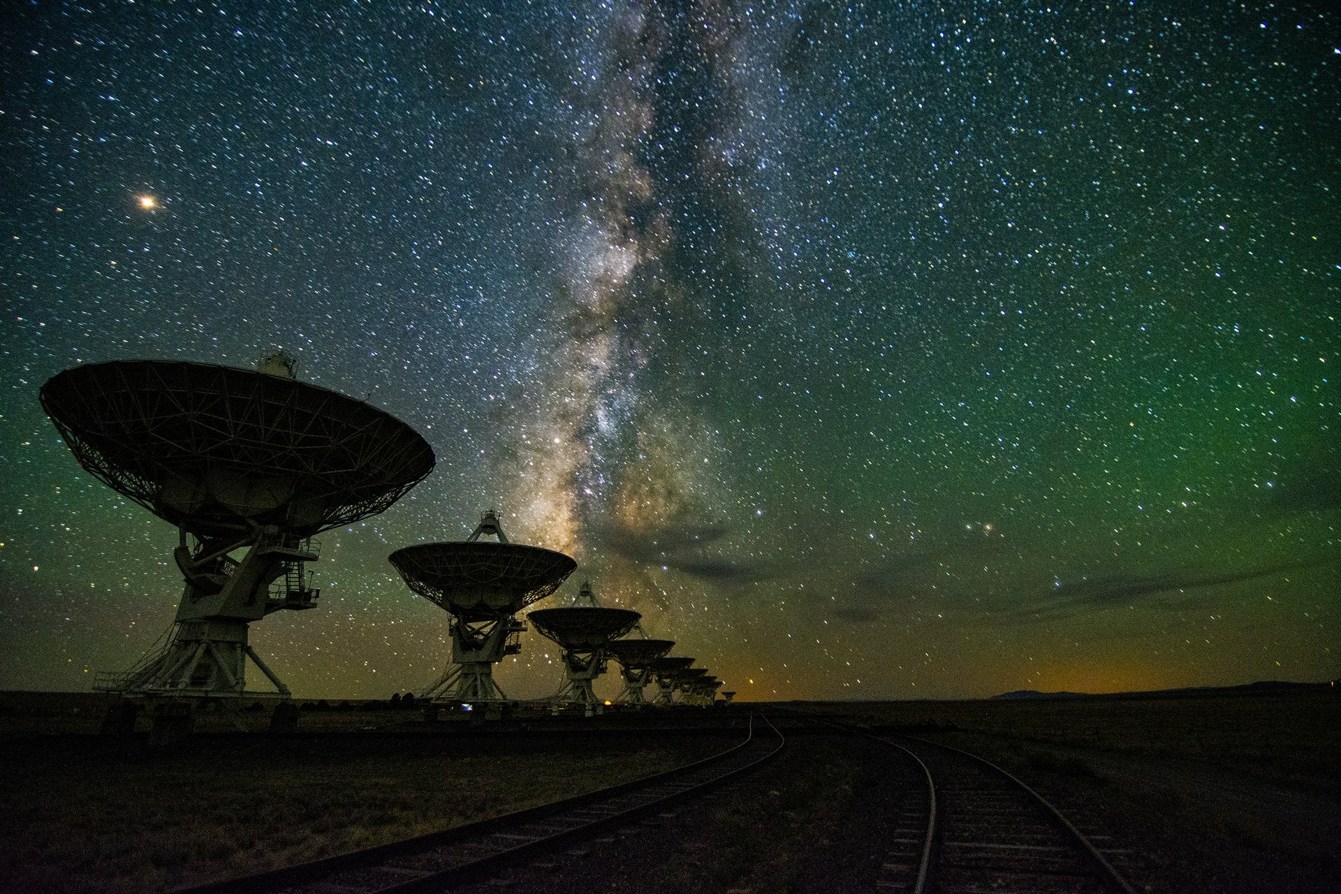
The Karl G. Jansky Very Large Array (VLA) in New Mexico at night. Credit: NRAO
More than sixty years ago, Dr. Frank Drake and his colleagues conducted the very first experiment dedicated to the Search for Extraterrestrial Intelligence (SETI). Since then, astronomers have continued to scan space for signs of alien transmissions, predominantly in the radio spectrum. In more recent years, the search has expanded to include thermal signatures and optical flashes, and additional forms of technological activity ("technosignatures") are already being incorporated. So far, all these experiments have produced null results, prompting SETI researchers to consider what they might be missing.
One possibility that repeatedly comes up is the notion that we are not looking in the right places. This certainly makes sense, since all SETI surveys to date have only covered a limited range of the radio spectrum. Following that logic, could it be that Earth has already received signals, but we didn't realize it because we weren't listening on the right frequency? According to a new study by Claudio Grimaldi, a researcher at the Laboratory of Statistical Biophysics at the Swiss Federal Technology Institute of Lausanne (EPFL), it's unlikely that we have.
The study, "Undetected Past Contacts with Technological Species: Implications for Technosignature Science," recently appeared in *The Astrophysical Journal*. Using Bayesian Analysis, a statistical technique that updates probabilities based on evolving data sets, Grimaldi examined how undetected past signals would have implications for current SETI surveys. In particular, he examined how past signals would increase the odds of detecting one today, and the likely source of those transmissions.
*The Milky Way galaxy, showing the central bulge at its center.
Credit: NASA*
As a starting point, he modeled technosignatures as active emissions or artifacts from an advanced civilization that then spread at the speed of light, lasting for brief periods (a matter of days) or for very long ones (millennia). He also considered how detection would only happen if the transmission is within range for the signal to be strong enough for our instruments to detect. He also considered omnidirectional signals (waste heat from megatructures) and highly focused signals (beacons, laser flashes, etc.). The resulting model addressed three possible elements:
The number of past contacts with Earth
The typical lifetime of technosignatures
The distance range that current or near-future instruments can probe
For "contact optimists," the results were not encouraging, suggesting that a very large number of undetected signals would have had to reach Earth in the past for there to be a high probability of detecting technosignatures closer to our Solar System today. In some cases, the number of signals exceeded the number of potentially habitable planets within a few hundred to a few thousands light-years from Earth, making any past or future signals highly unlikely. However, the results were different when extended to much greater distances.
Assuming technosignatures are long-lived and propagate across the entire Milky Way, detection becomes more likely at distances of several thousand light-years or more. However, the number of detectable signals across the entire galaxy at any given time remains very low. These results indicate that our inability to detect signals in the past does not mean detection will likely occur in the near future. Instead, they suggest that transmissions from advanced civilizations are likely to be rare, distant, and long-lasting, rather than local and frequent.
In other words, the field of SETI appears to be destined for a long wait before any discernible technosignatures (intentional or the result of "spillover") will be detected. Far from discouraging SETI efforts, however, the results suggest that future SETI efforts should focus on deeper, broader surveys that scan large parts of the Milky Way rather than individual stars or star clusters located a short distance away (in cosmic terms).
Not AGAIN! NASA's Artemis II moon mission is delayed for a second time after several last–minute issues are spotted on the SLS rocket – as furious fans call for SpaceX to step in
Not AGAIN! NASA's Artemis II moon mission is delayed for a second time after several last–minute issues are spotted on the SLS rocket – as furious fans call for SpaceX to step in
NASA's Artemis II moon mission has been delayed for a second time after several last–minute issues were spotted on the Space Launch System (SLS) rocket.
Mr Isaacman says that the reason for the delay is an 'interruption in helium flow in the SLS interim cryogenic propulsion stage'.
The system worked during both wet dress rehearsals, but engineers were unable to get helium flow through the vehicle during routine maintenance on Saturday night.
Now, as the long–awaited moon mission is pushed back once again, some frustrated fans have called for Elon Musk's SpaceX to step in with assistance.
Taking to X, one fan vented: 'Time to scrap the 1960s tech and innovate to build next gen space launch vehicles and to stay on par with SpaceX.'
NASA's Artemis II moon mission has been delayed for the second time, as last–minute technical issues are found in the Space Launch System (SLS) rocket
NASA administrator Jared Isaacman said that the issue had been caused by an 'interruption in helium flow in the SLS interim cryogenic propulsion stage'
Fed–up space enthusiasts have taken to social media to vent their irritation over the persistent delays.
One commenter wrote: 'At this rate, the Chinese will soundly beat us to the Moon.'
Others explicitly suggested that SpaceX should be called on to lend assistance or even replace the SLS rocket altogether.
On X, which is owned by SpaceX CEO Elon Musk, one commenter wrote: '@SpaceX Those guys need a ride to the moon, please help them.'
Another asked: 'When will NASA stop the financial haemorrhaging and turn this program over to SpaceX?'
'Can we get out of this contract and save money with SpaceX,' suggested another.
In particular, a number of space fans suggested that the experimental Starship rocket could make a viable replacement.
Mr Isaacman (left) says that the setback will 'almost assuredly' affect the intended March launch date, ruling out the Artemis II launch until April
Mr Isaacman says the systems performed well during both wet dress rehearsals, but unexpectedly failed during a 'routine operation'
On X, frustrated space fans have called for Elon Musk's SpaceX to provide assistance to the Artemis II programme
Why does NASA use hydrogen fuel?
The SLS rocket uses a mixture of liquid hydrogen and liquid oxygen.
Since hydrogen is such a small molecule, it is extremely prone to leaking.
However, hydrogen is also cheap, naturally abundant, and produces a phenomenal amount of energy.
According to NASA, this mix gives the 'highest specific impulse, or efficiency in relation to the amount of propellant consumed, of any known rocket propellant'.
Another important factor is that the SLS rocket inherits a lot of its hardware and systems from the Shuttle era rockets.
These engines were built to run on hydrogen, so NASA can't change fuels without an expensive redesign of the entire rocket and engine system.
'I beginning to think that the SpaceX Starship will be launching astronauts to space before the Artemis program,' one commenter suggested.
While one added: 'Time to replace SLS with Falcon Heavy. Might even actually do it faster with Starship.'
For context, SpaceX has been contracted by NASA to provide a modified version of Starship for the lunar landing during the Artemis III mission.
In April 2021, NASA awarded Elon Musk's company a $2.9 billion contract to provide the first crewed lunar lander, but SpaceX is widely expected to miss the 2027 target date.
Last year, acting NASA administrator Sean Duffy threatened to open up the contract to other countries due to persistent delays, saying at the time: 'The problem is, they're behind.'
However, NASA's immediate problems are the ongoing delays afflicting the problem–plagued SLS rocket.
Mr Isaacman says that the source of the problem could be located in one of the filers or quick–disconnect 'umbilicals' that pass gases between the ground and the rocket.
Alternatively, he says that the issue could have been caused by a 'failed check valve onboard the vehicle, which would be consistent with Artemis I'
Angry commenters lamented the costs of the SLS rocket and its persistent delays, arguing that the mission should be turned over to SpaceX
One commenter asked why America could 'get out of this contract' in order to save money with SpaceX
The SLS rocket will now need to roll back to the Vehicle Assembly Building at the Kennedy Launch Centre for repairs, meaning that another wet dress rehearsal is almost certain
After problems with the helium system were discovered overnight, NASA has now made the disappointing decision to roll SLS back to the Vehicle Assembly Building (VAB) at Kennedy Space Centre.
While the agency has a limited capacity to fix issues at the launch tower, more serious problems need to be addressed in the VAB, which gives engineers better access to the vehicle.
The vibrations caused by rolling the rocket in or out of the VAB risk loosening or disturbing seals and valves, meaning that one or two more wet dress rehearsals are almost certain.
After the success of the second wet dress rehearsal, the Artemis II crew entered quarantine in Houston, Texas, on Friday night.
During quarantine, the crew limit their exposure to other people so that they can stay in good health for the flight.
This procedure usually starts 14 days out from the launch date, but NASA has not said whether the crew will be able to leave quarantine before the April launch date.
Writing on X, Mr Isaacman added: 'I understand people are disappointed by this development. That disappointment is felt most by the team at NASA, who have been working tirelessly to prepare for this great endeavor.'
Launch date: NASA initially identified three possible launch windows for Artemis II: From February 6 to February 11, from March 6 to March 11, and from April 1 to April 6. The space agency is now targeting the April window.
Mission objective: To complete a lunar flyby, passing the 'dark side' of the moon and test systems for a future lunar landing.
Total distance to travel: 620,000 miles (one million km)
Mission duration:10 days
Estimated total cost: $44 billion (£32.5 billion)
- NASA Space Launch System rocket: $23.8 billion (£17.6 billion)
An exceptionally hungry black hole from the dawn of the universe is growing at 13 times the cosmic 'speed limit', experts say.
Astronomers have used high–tech telescopes to 'look back in time' to around 12 billion years ago, not long after the universe was born.
There, they spotted something unexpected – a supermassive black hole that already weighed 440 million solar masses.
This means it was growing at an unimaginably fast rate, they said, absorbing gas and dust quicker than it was believed possible.
According to theory, there should be a limit on how fast black holes can grow because the act of 'ingesting' matter creates an opposing force which prevents more matter from being absorbed.
But this cosmic giant, known as ID830, is defying expectations – and could mark the discovery of the fastest–growing supermassive black hole of a similar mass found to date.
Researchers suggest the black hole may have 'collided' with a star or clump of gas, giving it enough energy for this remarkable growth spurt.
'This discovery may bring us closer to understanding how supermassive black holes formed so quickly in the early universe,' lead author Sakiko Obuchi said.
A graph displaying ID830's uniquely brilliant luminosity, compared to previously observed objects. The solid line shows the upper 'limit' of how it should be growing
An artist's impression of a supermassive black hole. Gas accretes onto the central black hole, forming an accretion disk and jets
The team, from Waseda University and Tohoku University in Japan, used the Subaru Telescope to analyse the black hole.
What makes this one even more striking is its multiwavelength behaviour, the researchers, who published their findings in The Astrophysical Journal, said.
When black holes undergo growth spurts, most models predict that their structure changes in ways that can reduce X–ray emissions and that their plasma and radiation jets may be less obvious.
However, this particular black hole shines brightly in both X–rays and radio wavelength.
This unexpected combination suggests scientists still have more to learn about the mechanisms of early black hole growth, the team said.
'Going forward, we hope to explore the mechanisms of X–ray and radio wave emission from this quasar and determine whether there are any similar objects yet to be discovered,' Dr Obuchi said.
They suggest they may have observed the black hole during a short transitional period, possibly following a sudden influx of gas.
This could prompt both the X–ray–emitting corona and the radio jet to become highly energised before the system gradually settles into a more typical mode of growth.
In a press release from the universities, the researchers said: 'Data from the Subaru Telescope show a surprising mix of traits.
'The quasar is pulling in matter at an exceptionally high rate while also emitting intense X–rays and launching a strong radio jet.
Black holes are so dense and their gravitational pull is so strong that no form of radiation can escape them - not even light.
They act as intense sources of gravity which hoover up dust and gas around them. Their intense gravitational pull is thought to be what stars in galaxies orbit around.
How they are formed is still poorly understood. Astronomers believe they may form when a large cloud of gas up to 100,000 times bigger than the sun, collapses into a black hole.
Many of these black hole seeds then merge to form much larger supermassive black holes, which are found at the centre of every known massive galaxy.
Alternatively, a supermassive black hole seed could come from a giant star, about 100 times the sun's mass, that ultimately forms into a black hole after it runs out of fuel and collapses.
When these giant stars die, they also go 'supernova', a huge explosion that expels the matter from the outer layers of the star into deep space.
Onverwachte verschuiving van de magnetische noordpool
De magnetische noordpool van de aarde is aan het verschuiven. Hoewel dit eeuwenlang een geleidelijk proces is geweest, hebben recente waarnemingen een verandering in het tempo van de beweging aan het licht gebracht. Maar waarom gebeurt dit en wat zijn de gevolgen voor onze planeet?
Van de manier waarop onze smartphones werken tot de navigatie van vliegtuigen, de verschuivende magnetische noordpool heeft een verrassende invloed op ons dagelijks leven.
Geïntrigeerd? Klik door deze galerij om het zwervende magnetische veld van de aarde en de verrassende implicaties ervan te ontdekken.
Wat is het magnetische veld van de aarde? De aarde is een gigantische, bolvormige magneet. De aarde is omgeven door een magnetisch veld dat in de tijd en in de ruimte verschuift. Dit veld is afkomstig van verschillende bronnen binnen en buiten de aarde.
Als een staafmagneets Het lijkt erg op het veld dat wordt gecreëerd door een staafmagneet, maar dan geplaatst in het middelpunt van de aarde. Magnetische velden worden gecreëerd door bewegende elektrische ladingen. In een staafmagneet zijn deze ladingen elektronen die rondjes draaien in atomen.
William Gilbert Wetenschappers bestuderen het magnetisme van de aarde al eeuwenlang. William Gilbert, een 17e-eeuwse Engelse natuurkundige, was een pionier op dit gebied. Zijn experimenten en het gebruik van termen als 'elektrische kracht' en 'magnetische pool' legden de basis voor de moderne elektriciteit.
Reuzenmagneet Gilberts boek uit 1600, 'De Magnete', zorgde voor een revolutie in het begrip van magnetisme. Na uitgebreid onderzoek stelde hij voor dat de aarde zich gedraagt als een reusachtige staafmagneet, wat het gedrag van kompasnaalden en magnetische variaties gekoppeld aan geografische kenmerken verklaart.
Bevindingen Hij besprak het magnetisme van de aarde aan de hand van een model: een bolvormig stuk laststeen dat een terrella (kleine aarde) wordt genoemd. Magnetische naalden op een terrella wijzen naar de noordpool (aangeduid als punt A). Zelfs op een oneffen oppervlak, zoals bij punt O, wijzen de naalden nog steeds naar het noorden.
Vintage uitrusting In het begin van de 19e eeuw bestudeerden wetenschappers het magnetisme van de aarde met behulp van dipnaalden. Deze maten de hoek van het magnetische veld van de aarde op een willekeurig punt. Naalden staan horizontaal op de evenaar en verticaal op de polen. Wetenschappers gebruikten dompelnaalden op expedities vanaf de 18e eeuw.
Ontdekking De Schotse schout-bij-nacht Sir James Clark Ross ontdekte de Noordelijke Magnetische Pool in het noorden van Canada voor het eerst in 1831, na een aantal Arctische expedities.
Technische vooruitgang Een beter begrip van de magnetische polen van de aarde leidde tot vooruitgang in de navigatie. De 'True Course Finder', bijvoorbeeld, automatiseerde berekeningen voor zeelieden, waardoor ingewikkelde formules niet meer nodig waren. Vóór deze apparaten konden zeelieden alleen het magnetische noorden bepalen met een kompas, waardoor ze extra berekeningen nodig hadden voor het ware noorden.
In beweging Eeuwenlang hebben wetenschappers de magnetische noordpool gevolgd. In tegenstelling tot de stationaire geografische noordpool is de magnetische noordpool voortdurend in beweging. Tussen 1600 en 1900 bewoog hij ongeveer 10-15 kilometer per jaar.
Siberië-gebonden In de jaren 1990 dreef het naar de Atlantische Oceaan voordat het versnelde richting Siberië. Aan het begin van de jaren 2000 was de snelheid toegenomen tot ongeveer4 kilometer per jaar.
Siberië-gebonden In 2005 probeerden de Canadese geofysicus Larry Newitt en de Franse geoloog Jean-Jacques Orgeval het magnetische veld van de aarde vast te stellen tijdens een expeditie naar het Canadese noordpoolgebied. Ze bevestigden dat de dolende pool internationale wateren was binnengedrongen en op weg was naar Siberië.
Magnetisch Wereldmodel Het World Magnetic Model (WMM), gezamenlijk ontwikkeld door het Amerikaanse National Geophysical Data Center en de British Geological Survey (BGS), is een grootschalig model van het magnetisch veld van de aarde dat wordt gebruikt om de locatie van de pool te voorspellen. Het WMM wordt elke vijf jaar bijgewerkt en de nieuwste versie is nu beschikbaar.
Op de rem Terwijl de reis richting Rusland doorgaat, is de magnetische migratie van de Noordpool de afgelopen vijf jaar vertraagd tot ongeveer 35 kilometer per jaar. Deze snelheid van vertraging is volgens wetenschappers ongekend.
Canada vs. Rusland Een team onder leiding van professor Phil Livermore van de Universiteit van Leeds heeft een verklaring voorgesteld voor het recente gedrag van de magnetische Noordpool. Hij suggereert dat de pool gevangen zit in een touwtrekwedstrijd tussen twee concurrerende magnetische krachten, de ene onder Canada en de andere onder Siberië.
Canada vs. Rusland Livermore suggereert dat de Canadese magnetische patch uitgerekt en gesplitst is, waardoor de Siberische patch mogelijk sterker is geworden. Deze verschuiving in het evenwicht zou de verschuiving van de pool naar Rusland kunnen verklaren.
Wat veroorzaakt de beweging? De buitenkern van de aarde bestaat voornamelijk uit gesmolten ijzer, een vloeibaar metaal. Als warmte uit de kern ontsnapt, beweegt dit gesmolten ijzer en wordt het magnetische veld van de aarde opgewekt.
Ronddwarrelend Onvoorspelbare veranderingen in de wervelende beweging van dit gesmolten ijzer, dat zich ongeveer 3.218 kilometer onder het oppervlak bevindt, beïnvloeden het magnetische veld van de aarde en de positie van de magnetische pool.
Warme thee "Het is net een reusachtige kop thee," legt William Brown uit, een wereldwijde modelleur van het aardmagnetisch veld bij de British Geological Survey. "Het is een hete vloeistof met de substantie van water."
Implicaties voor de echte wereld De beweging van de noordelijke magnetische pool is cruciaal voor nauwkeurige navigatie. De gegevens die worden verzameld door de beweging te volgen, worden gebruikt om kompassen en andere navigatieapparaten te kalibreren.
Militaire navigatie Het leger vertrouwt ook op het World Magnetic Model voor nauwkeurige navigatie van onderzeeërs, vooral in moeilijke omgevingen zoals de Noordpool.
Luchthavens Landingsbanen van luchthavens zijn genummerd op basis van hun kompasrichting. Als het magnetisch veld van de aarde verschuift, moeten deze nummers worden bijgewerkt. De noordbaan van Berlin Brandenburg Airport veranderde bijvoorbeeld van 25R/07L naar 24R/06L in oktober 2024.
Constante bewaking Hoewel het onmogelijk is om exacte bewegingen te voorspellen, blijft de BGS het magnetische veld van de aarde in de gaten houden. Ze gebruiken een netwerk van grondstations en satellieten om het veld op verschillende locaties in kaart te brengen.
Pool flip? Wetenschappers weten dat het gesmolten ijzer in de kern van de aarde voortdurend wervelt en dat de magnetische polen altijd bewegen. Is het dan mogelijk dat er een volledige omkering plaatsvindt, waarbij het noorden het zuiden wordt en omgekeerd?
Magneetveld spiegelen De laatste volledige omkering vond 780.000 jaar geleden plaats. Een tijdelijke omkering vond 41.000 jaar geleden plaats, maar die duurde slechts 250 jaar voordat hij terugkeerde naar, de positie waar de polen zich vandaag de dag nog steeds bevinden.
Geen reden tot zorgen Hoewel omkeringen van de aardmagnetische polen alarmerend kunnen klinken, vinden ze over een lange periode plaats en vormen ze geen directe bedreiging voor het leven. Wetenschappers hebben bevestigd dat dergelijke gebeurtenissen geen significante kortetermijnveranderingen veroorzaken in het milieu van de aarde.
Scott Bray, former deputy director of Naval Intelligence, testifies during a House hearing on UAPs in 2022.
Photo: Kevin Dietsch/Getty Images
President Trump's decision to release government files related to aliens and UFOs is reigniting one of America's longest-running mysteries.
The big picture: While it's unclear whether any new significant surprises await, the belief that government secrets may prove extraterrestrial life exists has fueled curiosity and speculation for decades.
The latest chapter started when former President Obama said last week that aliens are real. He later clarified that he hadn't seen any evidence of aliens making contact with Earth.
But his remarks prompted Trump to suggest this was classified information and promise to release new records.
Here's what the government has previously shared:
What's confirmed by the government
Between the lines: Much of what's been confirmed has been about unidentified anomalous phenomena (UAPs) rather than "UFOs." UAPs are airborne objects that are not immediately identifiable.
The Office of the Director of National Intelligence (ODNI) confirmed in a 2021 report that UAPs are real, but there's no confirmation they stem from some extraterrestrial origin.
The Pentagon has largely maintained that there is no evidence of alien technology nor any hidden programs within the government related to UAPs.
UFOs have been on Congress' radar for years, mostly due to bipartisan concerns about transparency and national security.
Congress held a seriesof hearings from 2022 to 2024 as part of an investigation into UAPs and national security.
Several officials testified that UAP sightings have simple explanations — that they were actually balloons, drones and optical effects.
Officials also confirmed that hundreds of UAP reports exist, including military cases.
What they said:Sean Kirkpatrick, director of AARO, testified in April 2023 that many sightings involved "metallic orbs" — though he did not confirm extraterrestrial technology.
Whistleblower David Grusch testified in July 2023 that he believed the government was withholding evidence and information about UAPs.
A video of unidentified aerial phenomena plays during a House Intelligence subcommittee hearing in 2022. Photo: Kevin Dietsch/Getty Images
NASA, Pentagon downplay sightings
Flashback: In 2023, NASA released a report from its UAP study team that found no evidence of aliens.
However, the government agency said they aren't sure what UAP technically are and that more research could be done into defining the unidentified objects.
An unclassified 2024 Pentagon reportgave the public insight into what we know and don't know about UFOs.
The report mainly found that several of the sightings in the 1950s and '60s were likely caused by tests of advanced U.S. spy planes and other tech.
The report said there was no evidence of confirmed extraterrestrial activity related to UAPs.
Reported UFO sightings per 100k residents
Jan. 1, 1995, to Feb. 19, 2026; Approximate locations of 140,406 sightings submitted to the National UFO Reporting Center
A U.S. state map of reported UFO sightings per 100,000 residents from 1995 to 2026, as of February 19, 2026. About 140,000 sightings were reported in that time period, with the most sightings relative to population in Vermont (100 per 100,000 residents), Washington (95) and Montana (94).
Americans share reported sightingsall the time to the National UFO Reporting Center, which catalogs all reports for the public to read.
The most recent claim was on Feb. 10, when someone reported seeing a UAP in Cave Junction, Oregon, that was "a shooting star" that made "a zigzag pattern."
Of course, these reports are unconfirmed and anyone can file them.
By the numbers:The NUFORC collects data on where the most sightings have happened throughout the world.
California remains the state with the most reported sightings at 17,061 as of February 2026, per NUFORC.
The NUFORC reportsoffer varying details of what the unidentified objects look like.
More than 10,000 people described the UFOs as a "fireball," with 14,000 spotting a "triangle."
The bottom line: The truth is out there, and Trump's order could provide new evidence for believers and skeptics to seize on.
Beste bezoeker, Heb je zelf al ooit een vreemde waarneming gedaan, laat dit dan even weten via email aan Frederick Delaere opwww.ufomeldpunt.be. Deze onderzoekers behandelen jouw melding in volledige anonimiteit en met alle respect voor jouw privacy. Ze zijn kritisch, objectief maar open minded aangelegd en zullen jou steeds een verklaring geven voor jouw waarneming! DUS AARZEL NIET, ALS JE EEN ANTWOORD OP JOUW VRAGEN WENST, CONTACTEER FREDERICK. BIJ VOORBAAT DANK...
Druk op onderstaande knop om je bestand , jouw artikel naar mij te verzenden. INDIEN HET DE MOEITE WAARD IS, PLAATS IK HET OP DE BLOG ONDER DIVERSEN MET JOUW NAAM...
Druk op onderstaande knop om een berichtje achter te laten in mijn gastenboek
Alvast bedankt voor al jouw bezoekjes en jouw reacties. Nog een prettige dag verder!!!
Over mijzelf
Ik ben Pieter, en gebruik soms ook wel de schuilnaam Peter2011.
Ik ben een man en woon in Linter (België) en mijn beroep is Ik ben op rust..
Ik ben geboren op 18/10/1950 en ben nu dus 75 jaar jong.
Mijn hobby's zijn: Ufologie en andere esoterische onderwerpen.
Op deze blog vind je onder artikels, werk van mezelf. Mijn dank gaat ook naar André, Ingrid, Oliver, Paul, Vincent, Georges Filer en MUFON voor de bijdragen voor de verschillende categorieën...
Veel leesplezier en geef je mening over deze blog.