The purpose of this blog is the creation of an open, international, independent and free forum, where every UFO-researcher can publish the results of his/her research. The languagues, used for this blog, are Dutch, English and French.You can find the articles of a collegue by selecting his category. Each author stays resposable for the continue of his articles. As blogmaster I have the right to refuse an addition or an article, when it attacks other collegues or UFO-groupes.
Druk op onderstaande knop om te reageren in mijn forum
Zoeken in blog
Deze blog is opgedragen aan mijn overleden echtgenote Lucienne.
In 2012 verloor ze haar moedige strijd tegen kanker!
In 2011 startte ik deze blog, omdat ik niet mocht stoppen met mijn UFO-onderzoek.
BEDANKT!!!
Een interessant adres?
UFO'S of UAP'S, ASTRONOMIE, RUIMTEVAART, ARCHEOLOGIE, OUDHEIDKUNDE, SF-SNUFJES EN ANDERE ESOTERISCHE WETENSCHAPPEN - DE ALLERLAATSTE NIEUWTJES
UFO's of UAP'S in België en de rest van de wereld Ontdek de Fascinerende Wereld van UFO's en UAP's: Jouw Bron voor Onthullende Informatie!
Ben jij ook gefascineerd door het onbekende? Wil je meer weten over UFO's en UAP's, niet alleen in België, maar over de hele wereld? Dan ben je op de juiste plek!
België: Het Kloppend Hart van UFO-onderzoek
In België is BUFON (Belgisch UFO-Netwerk) dé autoriteit op het gebied van UFO-onderzoek. Voor betrouwbare en objectieve informatie over deze intrigerende fenomenen, bezoek je zeker onze Facebook-pagina en deze blog. Maar dat is nog niet alles! Ontdek ook het Belgisch UFO-meldpunt en Caelestia, twee organisaties die diepgaand onderzoek verrichten, al zijn ze soms kritisch of sceptisch.
Nederland: Een Schat aan Informatie
Voor onze Nederlandse buren is er de schitterende website www.ufowijzer.nl, beheerd door Paul Harmans. Deze site biedt een schat aan informatie en artikelen die je niet wilt missen!
Internationaal: MUFON - De Wereldwijde Autoriteit
Neem ook een kijkje bij MUFON (Mutual UFO Network Inc.), een gerenommeerde Amerikaanse UFO-vereniging met afdelingen in de VS en wereldwijd. MUFON is toegewijd aan de wetenschappelijke en analytische studie van het UFO-fenomeen, en hun maandelijkse tijdschrift, The MUFON UFO-Journal, is een must-read voor elke UFO-enthousiasteling. Bezoek hun website op www.mufon.com voor meer informatie.
Samenwerking en Toekomstvisie
Sinds 1 februari 2020 is Pieter niet alleen ex-president van BUFON, maar ook de voormalige nationale directeur van MUFON in Vlaanderen en Nederland. Dit creëert een sterke samenwerking met de Franse MUFON Reseau MUFON/EUROP, wat ons in staat stelt om nog meer waardevolle inzichten te delen.
Let op: Nepprofielen en Nieuwe Groeperingen
Pas op voor een nieuwe groepering die zich ook BUFON noemt, maar geen enkele connectie heeft met onze gevestigde organisatie. Hoewel zij de naam geregistreerd hebben, kunnen ze het rijke verleden en de expertise van onze groep niet evenaren. We wensen hen veel succes, maar we blijven de autoriteit in UFO-onderzoek!
Blijf Op De Hoogte!
Wil jij de laatste nieuwtjes over UFO's, ruimtevaart, archeologie, en meer? Volg ons dan en duik samen met ons in de fascinerende wereld van het onbekende! Sluit je aan bij de gemeenschap van nieuwsgierige geesten die net als jij verlangen naar antwoorden en avonturen in de sterren!
Heb je vragen of wil je meer weten? Aarzel dan niet om contact met ons op te nemen! Samen ontrafelen we het mysterie van de lucht en daarbuiten.
20-02-2022
NASA Used Codewords ‘Santa Claus’ For Three UFOs Seen On Moon During Apollo Missions
NASA Used Codewords ‘Santa Claus’ For Three UFOs Seen On Moon During Apollo Missions
NASA’s new chief Bill Nelson has recently begun to study UFOs after the US government showed a serious interest in them. He personally does not believe that the UFOs are extraterrestrial and if that was the case then he would know.
Eventually, he stated that people cannot rule out the other possibility as well. NASA has been exploring space for a long time and there are chances that they have found a sign of aliens but hiding it from the public. There are someNASA legendssuch as Gordon Cooper, Edgar Mitchell and Story Musgrave, who are firm believers of UFOs.
Donna Hare
NASA conspirators have a full assurance that the US space agency has been covering the evidence of UFOs since the first Apollo mission. Donna Hare claimed to have worked for NASA contactor Philco Ford in the early 1970s. She had a high-security clearance to walk in NASA’s photo lab and other departments.
During the Disclosure Project press conference, Hare revealed that NASA covered up and eliminated space anomalies such as UFOs from the satellite photos. Hare has got several awards in the space programs. She dedicated most of her time as a technical illustrator in space programs. She created lunar maps, landing slides and had been working 15 years as a sub-contractor for NASA.
With a half-earth in the background, the lunar module “Eagle,” carrying Neil Armstrong and Edwin Aldrin, approached the Apollo command module manned by Michael Collins after Messrs. Armstrong and Aldrin walked on the moon. Image credit: NASA
She claimed to have access to a place known as “Building Eight,” from where she made contacts with high-ranking officials. Once, she walked into a restricted area which was NASA’s photo lab. She noticed the lab had photographs (mosaic) of the Moon taken from satellites. She was with a friend who pointed at one of the photographs and surprisingly, she saw a round white dot.
“I said to him what is that. Is that a dot on the emulsion? Then he’s grinning and he says dots on the emulsion don’t leave shadows on the ground. There was a round shadow at the correct angle.
I looked at him and I was pretty startled because I’d worked out there several years and never seen anything like this never heard of anything like this and I said is this a UFO and he’s smiling at me and he says I can’t tell you,” Hara said. She knew what he meant but could not tell. He said that their work was to airbrush them before putting into the public domain.
According to her, NASA had a protocol to alter the satellite images, and workers who were assigned to this program were put in quarantine. She was told by one of the sources that during one of the moon landings, three UFOs had landed. Subsequently, there was a codeword “Santa Claus” for these crafts.
No one was allowed to talk about these in public, otherwise they would face serious consequences after retirement. She remembered that one person from that secret program told her that every astronaut had seen those crafts during their space missions. She had never seen that man again but got his name which was given to Ufologist Dr. Steven Greer in a hope that he would find him.
Sergeant Karl Wolfe
Former US Air Force Sergeant Karl Wolfe, who died in a bike accident in 2018, was another person who shared a similar story. He also had top-secret clearance and worked at Langley Air Force base in Virginia, the USA.
Karl worked as a precision electronics photograph repairer for Nasa’s Lunar Orbiter Project. One day, he was taken into a lab by another worker who showed him a photo of artificial buildings at the lunar base. His death remains a mystery as many believe that he was killed for exposing top-secret documents.
Major Robert Orel Dean
Karl was not the only whistleblower whose death seems mysterious. Former U.S. Army Command Sgt. Major Robert Orel Dean claimed that when he worked for NATO in France, he read a document titled “The Assessment” in the 1960s. According to him, the document consisted the information about “photos of dead aliens, crashed UFOs and reports by military pilots and scientists.” Coincidently, he also died a week before Karl’s death in 2018.
Remember how we had “alien invasion” on our 2020 bingo card? Well, we might just be able to check off that box. On Dec. 29, at roughly 8:30 p.m. local time, eyewitnesses on the Hawaiian island of Oahu spotted an unidentified flying object in the night sky, prompting several 911 calls. As reported by Hawaii News Now, the UFO, which was caught on video, had a glowing blue oblong form, described by one onlooker as “larger than a telephone pole.” It sailed across the sky for several miles before crashing silently into the sea.
One witness, identified by Hawaii News Now as a woman named Moriah, saw a second UFO — this one with a whitish hue. “The white one was smaller. Was coming in the same direction as the blue one,” Moriah told Hawaii News Now. It disappeared from her sight as it flew over a neighboring town.
Local police reported the UFO sightings to the Federal Aviation Administration (FAA), in the event there was a downed aircraft, but the FAA said that no planes had disappeared from radar in the area, nor were any deemed overdue or missing.
But don’t go putting on your tinfoil hat just yet. These sightings are not likely extraterrestrial in nature, as is the case with most UFOs. In fact, some internet sleuths have already proffered a plausible explanation: The floating blue object bears resemblance to an LED kite, as demonstrated in this video by fact-checking Twitter account UFO of Interest.
So, as it turns out, 2020 just wasn’t the year for aliens, but who knows what 2021 will bring.
It’s hard to conceptualize the bizarre quantum behavior of subatomic particles, which are often too tiny, fleeting, and counterintuitive to conceptualize on any tangible scale. But new research bucks that trend, suggesting that an unusual quantum phenomenon could have a serious impact to biological structures — even causing point mutations in molecules of DNA.
The upshot is that the hydrogen bonds that link together two spiraling strands of DNA are prime for an unusual quantum process called proton tunneling, according to research published by University of Surrey scientists last month in the journal Physical Chemistry Chemical Physics.
Proton tunneling happens when a proton seemingly vanishes and reappears elsewhere on the other side of a physical or energetic barrier. Protons are massive compared to other subatomic particles that exist on the quantum scale, so it’s not as common to see a proton tunnel as it is to see something like an electron tunnel. But it is possible, and when it happens within a DNA molecule, it can essentially move atoms to the wrong place, leading to a mutation in the genetic code.
“Many have long suspected that the quantum world — which is weird, counter-intuitive, and wonderful — plays a role in life as we know it,” lead author and Surrey chemist Marco Sacchi said in a press release. “While the idea that something can be present in two places at the same time might be absurd to many of us, this happens all the time in the quantum world, and our study confirms that quantum tunneling also happens in DNA at room temperature.”
The odds that one of these quantum mutations would lead to medical problems down the line is rare — the paper notes that the DNA molecules are capable of righting themselves in fairly short order. But just like with any other mutation, it is possible that these mutations take hold and propagate through the DNA replication process, potentially causing issues or even increasing the risk of cancer.
“There is still a long and exciting road ahead of us to understand how biological processes work on the subatomic level,” study coauthor and quantum biologist Louie Slocombe said in the release, “but our study — and countless others over the recent years — have confirmed quantum mechanics are at play.”
A mockup of ESA's aspirations for its future Moon Village.
We've all fantasized of visiting somewhere exotic. For most of us, that dream spot is somewhere on Earth. But for some, the ultimate must-see destination isn't on our planet at all.
NASA is currently planning a series of 37 rocket launches, both robotic and crewed, that will culminate with the 2028 deployment of the first components for a long-term lunar base, according to recently leaked documents obtained by Ars Technica. An outpost on the Moon is surely an exciting prospect for both science geeks and prospective solar-system sightseers, but some believe NASA’s timeline is a too ambitious to be realistic.
This cutaway shows the interior of a 3D printed section of ESA's planned Moon Village.
ESA/Foster + Partners
It takes a village
The project, dubbed Moon Village, first made headlines back in 2015, when the newly appointed Director General of the ESA, Johann-Dietrich Woerner, told the BBC about his vision. "A Moon Village shouldn't just mean some houses, a church, and a town hall," he said at the time. "This Moon Village should mean partners from all over the world contributing to this community with robotic and astronaut missions and support communication satellites."
Though Woerner's comments gave the Moon Village concept its initial momentum, since then, much of the cooperation and planning for the lunar outpost has been spearheaded by the Moon Village Association (MVA), a non-governmental organization with about 150 members spread across nearly three dozen countries. Working closely with the ESA, the purpose of MVA is to foster collaboration between nations and organizations spread all over the world — especially in developing countries — to help bring visions of a permanent lunar base to fruition.
Moon Village is not just going to be another International Space Station on the Moon, said Senior Space Policy Adviser and President of the Moon Village Association, Giuseppe Reibaldi, in a presentation. Instead, Moon Village aims to be a collaboratively designed and expandable permanent lunar settlement that can serve as: an innovative research hub for industry and academia alike; an otherworldly destination for commercial travelers; and a proving ground for future crewed bases on Mars and beyond.
"The goal of the organization is to go beyond space, to go beyond the stars," said Reibaldi, "because this is a step for all humanity, and nobody needs to be left out."
Working with the European Space Agency, artist Jorge Mañes Rubio imagined a lunar colony built on the rim of Shackleton Crater, barely noticeable here as just a bright dot.
ESA/Jorge Mañes Rubio. Spatial design & visualization in collaboration with DITISHOE
In addition to copious amounts of available sunlight, at about 2.5 miles (4 kilometers) deep, the floor of Shackleton Crater is constantly cloaked in shadow. This means it’s the perfect place to hide valuable, sunlight-sensitive volatile resources like water-ice. Such a find nearby could provide residents of Moon Village with drinking water, breathable air, and a potential source of rocket fuel, as long as we have the means to unlock it.
Designing a Moon base
According to the plan, Moon Village will be built in incremental steps. First, individual landers will descend to the lunar surface near Shackleton Crater, at which point they'll each deploy inflatable modules. These modules, which are expected to be up to four-stories tall, would eventually serve as workspaces, residential areas, scientific labs, industrial sites, and environmental habitats.
The inflatable modules, however, cannot effectively shield humans from harmful radiation, temperature swings, or micrometeorite strikes. So, the ESA and MVA are currently working with private industries to design robots that can 3D print a protective shell around each structure using readily available regolith taken from the lunar surface.
Researchers estimate it should take a pair of such robots about three Earth months to construct a solid dome around an inflatable module. And as more of these habitats are built, they will be networked together through a series of pressurized walkways connected to airlocks at each module.
Making it happen
Europe, NASA, and even China are all currently working toward the goal of establishing a long-term presence on the Moon. But the reality is that no matter who gets credit for building the first reliable lunar settlement, it will likely one day morph into a massive international collaboration unlike anything humans have ever seen.
With the ESA and MVA spending time thoughtfully considering the best approaches for building an expandable, adaptable, and most of all permanent lunar base, Moon Village is definitely worth keeping an eye on.
Secret Underwater Military Base: Diego Garcia - A Black Project Military Base With Secrets To Hide (video)
Secret Underwater Military Base: Diego Garcia - A Black Project Military Base With Secrets To Hide (video)
Guantanamo Bay in Cuba is the most famous, less known is the camp in Bagram, Afghanistan. And almost nothing is known about Diego Garcia…
Diego Garcia is a 17 sq. mile horseshoe-shaped atoll in the Indian Ocean’s Chagos Archipelago. It has a tropical climate with thick jungles and white sand beaches.
The island’s value is its strategic location between East Africa, the Middle East, and Southeast Asia, making it a vital asset for supplying US naval forces and projecting air power into Asia and the Middle East.
During the Cold War, Britain agreed to lease Diego Garcia to the American military for the construction of a naval base on the island.
To make way for the base some 2,000 native Chagossians were forcibly removed from the island by the British government between 1968 and 1973. The islanders have since sued unsuccessfully for the right to return home.
An estimated 3,000-5,000 military and civilian personnel now live on Diego Garcia, most of them American and British.
The US military base on the island of Diego Garcia (aka Camp Justice aka ) and owned by the UK is one of the most strategically located and secretive U.S. military installations outside the United States.
It is known as a top-secret CIA prison where terror suspects are interrogated and tortured. Diego Garcia’s history includes disclosures by Washington insiders, military strategists, and exiled islanders, as well as hundreds of declassified documents.
Investigators long suspected the island was a clandestine CIA “black site” for high-profile detainees, although actions of the US and UK Military have been so covert that proof is not so easy to find, until now. The official name of the base is British Indian Ocean Territory (BIOT) Diego Garcia is thought to be the most environmentally pristine atolls in the world. The official name of the military base is Camp Thunder Cove.
“Today, the main island of Diego Garcia is America’s largest military base in the world, outside the US. There are more than 4,000 troops, two bomber runways, thirty warships and a satellite spy station. The Pentagon calls it an “indispensable platform” for policing the world. It was used as a launch pad for the invasions of both Afghanistan and Iraq”.
In 2007, the Pentagon granted a $32 million contract to add a submarine base to the island’s existing dock.
This small cluster of atolls was once home to some 2,000 Chagossians who had lived there for generations. The most populated island is Diego Garcia whose resident islanders lived by working the coconut plantations, farming on small plots of land, and fishing for lobster.
In 1966, the UK and the US implemented a joint military strategy and the archipelago was leased to the US for 50 years, until 2016. The purpose was to build a US military base on Diego Garcia. Although no money was ever received by the UK government, documents reveal that the US gave the UK a $14 million discount on the purchase of missiles.
However, the big problem with this plan was that the islands were already inhabited. The UK government expelled the islanders by force. The 50 year lease expires in 2016, which meant the exiled residents could now return to the island of Diego Garcia.
As if the story could not get any more evil, it took another sinester turn in 2010 when the UK government established a marine protected area (MPA) around the islands claiming that there would cease to be “”human footprints” or “Man Fridays” on the islands moving forward. This has also fostered a rare alliance between environmentalists and the U.S. military.
On the Chagos Reservation Trust website , an organization that is dedicated to the protection of the reserve, it is made clear that human inhabitants are not welcome.
So what are they saying? Are they actually trying to have us believe that an island taken over by the US Military 2 decades ago with an airfield capable of handling nuclear bombers and a seaport where supplies for much of the region are stored aboard pre-positioned ships is suddenly concerned with “human footprint” on the environment? Really?
According to a 2009 classified memo circulated internally in London, an official insisted that the establishment of a marine park — the world’s largest — would in no way impinge on [US Government] use of the archipelago, including Diego Garcia, for military purposes. He said that the former inhabitants would find it difficult, if not impossible, to pursue their claim for resettlement on the islands if the entire Chagos archipelago were a marine reserve.
The summary paragraph of the memo clearly dictates the intent of the MPA which states:
“HMG would like to establish a “marine park” or “reserve” providing comprehensive environmental protection to the reefs and waters of the British Indian Ocean Territory (BIOT), a senior Foreign and Commonwealth Office (FCO) official informed Polcouns on May 12. The official insisted that the establishment of a marine park — the world’s largest — would in no way impinge on USG use of the BIOT, including Diego Garcia, for military purposes.
He agreed that the UK and U.S. should carefully negotiate the details of the marine reserve to assure that U.S. interests were safeguarded and the strategic value of BIOT was upheld. He said that the BIOT’s former inhabitants would find it difficult, if not impossible, to pursue their claim for resettlement on the islands if the entire Chagos Archipelago were a marine reserve.”
The Chagossians used the cable for a high court application to order a judicial review of the government’s decision to create the MPA. They argued that the cable revealed the government’s true motives for creating the MPA; to prevent the islanders from returning home.
Keep in mind that British officials forcibly expelled approximately 2,000 Mauritians living in Chagos to make way for American military installations. The UK has stated that the Chagos will be returned to Mauritius once the islands are no longer required for defense purposes. Again the lease expires in 2016.
Regarding the occupation of the US Military’s “footprint”? Does it apply?
The last time I checked, the military was made up of flesh and blood; in other words, ‘men and women’. This “Marine Reserve Concept” is not only utterly absurd, it’s a clear and unfortunate example of how ruling countries misuse their power to force themselves on smaller less powerful countries; and for the record, it’s called stealing. It is also What do the people have to say?
“Great Britain and the United States should do honor to their status as great powers and sit down with us to negotiate a formal, legal transfer of sovereignty.”
In March of 2014 , The Chagos Refugee Group whose mission is to to provide help and support to refugees from Chagos Archipelago in Mauritius and the Seychelles Islands, Crawley and other parts of the United Kingdom and to promote their welfare and protect their interests, publicly addressed the issue by stating:
“For years, Great Britain has repeatedly used its power and influence to stymie the peaceful resolution of this dispute. In 2012, Mauritius announced that it would leave the Commonwealth if necessary in order to take the Chagos issue before the International Court of Justice. But the UK immediately amended its declaration relating to the jurisdiction of the Court so that the ICJ would not have mandatory jurisdiction if a case was brought against it.
In 2010, Britain declared a Marine Protected Area around the archipelago, and in response Mauritius initiated proceedings against the UK under Annex 7 of the United Nations Convention on the Law of the Sea. The African Union and Non-Aligned Movement have expressed unanimous support for Mauritius over the Chagos issue.
Now is the time to do the right thing and begin negotiations over the return of the Chagos Archipelago to its rightful owner, the Republic of Mauritius. The era of colonialism is over. Russia’s actions in Crimea are a searing reminder that the international community will no longer tolerate the forceful subjugation of weaker states by their more powerful neighbors.
Mauritius is acting responsibly, consistent with recognized international norms, to resolve this dispute peacefully. The West has the opportunity to match its words with deeds. Great Britain and the United States should do honor to their status as great powers and sit down with us to negotiate a formal, legal transfer of sovereignty.”
Washington has no interest in being the subject of protracted challenges against the legality of the territory on which it maintains a vital military facility. As a close ally and strategic partner, Mauritius will continue to provide full access and basing rights to the United States on Diego Garcia.
By accepting Mauritian sovereignty, the UK will not prejudice its position with respect to other colonial territories, nor will it prejudice the “defense purposes” by which it justifies its continued occupation of the islands.
Diego Garcia Facts
Diego Garcia is governed by the British UK represents the Territory internationally. Local government does not exist.
The administration is represented in the Territory by the Officer commanding British Forces on Diego Garcia, the “Brit Rep”. (administered by a commissioner, resident in the Foreign and Commonwealth Office in London)
Laws and regulations are promulgated by the Commissioner and enforced in the BIOT by Brit Rep.
No known regular military forces exist on Diego Garcia(2014)
Short of a major change in how we hold the state accountable, it will continue to conveniently lose evidence showing its part in serious abuses, and our political “watchdogs” will continue to be either unable or too useless to do anything about it.
The lease for the US Military expires in 2016
In 2004, the UK applied for, and received, RAMSAR SITE wetlands conservation status for the lagoon and other waters of Diego Garcia. In other words, the US declared it a wetlands conservatory.
On 1 April 2010, the UK Cabinet declared the Chagos Archipelago a Marine Protected Area (MPA) and prohibited all extractive industry, including fishing and oil and gas exploration. It is unclear whether Diego Garcia is included in the MPA.
The US Military has spent Billions of dollars (to date) on this secret military facility
Defense is the responsibility of the UK; the US lease on Diego Garcia expires in 2016.Diego Garcia is hiding in plain sight.
Note: This is an obvious violation of HUMAN RIGHTS . But the story does not end here. *Why would the UK and US military want to completely isolate these islands by removing all humans and inhabitants under the guise of environmental issues that currently do not even exist in Diego Garcia?
Here is where the story takes a hard left.
Question: What are they really hiding?
Answer: Possible Alien technology: Strange Facilities Under the Sea on the island of Diego Garcia.
Diego Garcia harbors more than one secret, some reports claim that the military is harboring an underwater base that allegedly utilizes alien technology.
There seems to be photographic evidence of the existence of under water bases as well.
A Popular Mechanics investigation TRACKED DOWN SOME OF THE MOST INTERESTING ACTIVE MILITARY FACILITIES AND SPOKE WITH BRAD SCHULZ, VICE PRESIDENT OF FEDERAL ARCHITECTURE AT HNTB.
“There’s a certain amount of logistical difficulty” with ultra-remote facilities like Diego Garcia, and shipping materials can be costly. Diego Garcia’s remoteness, though, allows it to be a key hub for tracking satellites, and it is one of five monitoring stations for GPS. Additionally, the island is one of only a handful of locations equipped with a Ground-based Electro-Optical Deep Space Surveillance system for tracking objects in deep space. As an atoll, the land itself is rather oddly shaped, too. From end to end, Diego Garcia is 34 miles long, but its total area is only 11 square miles.” ~Shultz
Evidence to support Schultz’s statement includes Diego Garcia’s affiliation with the 22d Space Operations Squadron (22 SOPS) which develops, publishes, executes, and enforces the network operations tasking order, as well as operating and maintaining worldwide remote tracking stations and associated communications systems comprising the Air Force Satellite Control Network (AFSCN).
It additionally coordinates launch and on-orbit operations of Department of Defense and other national agencies’ satellites in support of war fighters, the President, and the Secretary of Defense.
In addition, the base is supported by the 18th Space Control Squadron (18 SPCS) which is a a space surveillance unit, and lastly, the squadron supports NASA‘s space mission.
Could this be the location in which many of the Underwater UFO’s or USO’s (Unidentified Submerged Object) have been stored and from whence some of the USO sightings are originating ?
Note:One of the private contractors for Diego Garcia Military complex is a manufacturer by the name of Alion Science. Interesting name isn’t it?
December 04, 2014 Alion Awarded $4.5M Contract to Support Air Force Research Laboratory with Research and Development of Software-Based, Wireless Communications Systems
September 30, 2014 Alion Awarded $34 Million Navy Contract to Support Platforms, Sensors and Launch Systems
July 30, 2014 Alion Launches Risk Assessment Solution for the Chemical Industry Based on Technology Developed for DHS
NOTE: Birth of the Black Budget
“In 1947, the National Security Act created the National Security Council, the Central Intelligence Organization (CIA) and consolidated the US military into one entity, the Department of Defense (DoD). One of the issues that remained unresolved from the creation and operation of the CIA was the extent to which its budget and intelligence activities would remain a secret. According to Article 1, sec. 9, of the US Constitution,
“No money shall be drawn from the treasury, but in consequence of appropriations made by law; and a regular statement and account of receipts and expenditures of all public money shall be published from time to time.”
This constitutional requirement conflicted with the need for secrecy concerning Congressional appropriations for the CIA. The solution was for Congress to pass legislation approving the secrecy over the funding mechanisms used for the CIA and its intelligence related activities.
The necessary bill was passed with great haste and minimal debate causing considerable concern among those few Congressmen brave enough to openly challenge the constitutionality of the Act. Congressman Emmanuel Celler of New York voted for the bill but protested:
“If the members of the Armed Services Committee can hear the detailed information to support this bill, why can’t the entire membership? Are they the ‘Brahmins’ and we the ‘ untouchables’?
If you’ve got the money, the time, the power and the ingenuity at your fingertips, why not take over an island of your own? In the privacy of your own home, you could build an off world craft using reverse engineering, fly back and forth to the moon with your friends and family, and no one would ever know! You could call it BS, Baracuda Space.(Or in this case, Diego Garcia.)
The on going targeting of extraterrestrial vehicles by exotic weapons systems is certainly a major cause for concern, so play nice kids!
Diego Garcia Facts: Seven Things You Didn’t Know:
Diego Garcia is technically part of the UK, located on the content of Asia and part of the British Indian Ocean Territory. The US were granted permission to use the island as a military base in 1966 in exchange for cancelling a $14 million British debt for a military hardware purchase. Diego Garcia is now home to around 4,000 military personnel and support staff in 654 buildings.
Diego Garcia is the site of an ancient volcano. However, it has now been reduced to a horseshoe-shaped coral reef, with a perimeter of approximately 40 miles and a maximum elevation of 22 feet. It stretches for 15 miles, north to south, and about 35 miles from tip to tip of its horseshoe shape.
According to the 2009 book ‘Island of Shame’, when the US Navy took control of Diego Garcia it forcibly removed its 2,000 inhabitants, sending them to Mauritius and the Seychelles, where they were left on the docks, with no money and no housing, to fend for themselves. Prior to their departure their pet dogs were rounded up and gassed, their bodies were burned in front of their eyes.
As well as the network of GPS satellites, there are just five ground antennas the world that assist the operation of the Global Positioning System, and one of those antennas is located on Diego Garcia.
Retired United States Army General Barry McCaffrey twice made claims that Diego Garcia is the site of a secret US prison camp.
These rumours could be routed in claims of credible evidence exists supporting allegations that ships serving as black sites have used Diego Garcia as a base. However, in 2004, the British Foreign Secretary Jack Straw stated that US government had repeatedly assured him that no detainees had passed in transit or been held on Diego Garcia.
.The island was a major launch pad for the US attacks on Afghanistan and Iraq. The island is home to some of the US’s most deadly planes, including B-52s, B-1Bs and B-2 bombers. In 2007, the Pentagon granted a $32 million contract to add a submarine base to the island’s existing dock.
Conspiracy theorist made wild claims, that missing Malaysian flight MH370 was landed on the more than adequate runway of Diego Garcia. A freelance journalist claims to have received a photo via text message from an MH370 passenger calling himself Phillip Wood. Data contained with in the black iPhone photo contained GPS information which placed Wood on the island.
The internet was quick to quash these claims offering the more likely explanation that the photo is a fake. The question of whether the plane was landed on the island was asked in a White House press conference, press secretary Jay Carney simply answered “I’ll rule that one out.”
When the elite of the World start preparing for doomsday, that is a very troubling sign. And right now the elite appear to be quietly preparing for disaster like never before.
Hey check this out. Thanks to Mars hunter Whatsupinthesky, we have a shocking photo of the environmental damage NASA is committing on Mars. The Mars rover was taking photos as usual and right smack dab in the middle of one of its photos is an old part that fell off the rover. This was taken a few days ago. This rover is the Mars Perseverance and it took the photo on Sol 353. Its obvious that this structure came off the rover or was dumped off because its no longer useful. But littering on an Mars? Dumping our crap on other planets? What if other intelligent species see this? They will think we are destroying the Earth and will do the same to all planets we visit. Not at all ethical or moral of NASA to do that. Mars is not ours...the moon is not ours...its theirs. The universe is a first come first served kinda place. And humanity sits on a planet thats only 3.4 billion years old and other aliens come from planets 4-13 billion years. We are late to enter the game. I'm sure NASA would shrug it off and say, "hey...its just garbage."
It looks like I'm on somebody's list in the government. I'm on Wikileaks...a site that discloses secret documents and data of the US government so that the public can learn about it. It's about a UFO article on Before Its News site a few years back, and the email is addressed to a US gov spy (think tank) news site that pretends to gather world news info for the public, but really gathers it for the US government intel. I know this because this news site https://www.stratfor.com is in a lot of documents in Wikileaks...including to Hillary Clinton and many US presidents. So...big brother is watching. Lets hope those poor saps are learning from all this UFO and alien intel they are gathering, so it will make the change from within the government. Scott C. Waring
UFO Crash, Castle, Egyptian Face Found On Sandwich Islands, UFO Sighting News.
UFO Crash, Castle, Egyptian Face Found On Sandwich Islands, UFO Sighting News.
Date of discovery:Feb 18, 2022
Location of discovery: Sandwich Islands
Google earth coordinates:
UFO 54°39'43.26"S 36°11'41.58"W
Buildings 54°41'46.19"S 36° 7'21.69"W
Face 54°36'50.77"S 36°10'38.34"W
Hey I found a few things near Antarctica yesterday. They are located on the Sandwich Islands. I used Google Earth to find them and you have to follow my instructions to go to the 2010 date to see the correct images, because todays images are so white nothing can be seen. It seems that Google wanted to hide some things this way, but they forgot the older images.
I found an object which looks like a crashed UFO. It left a long trail, so either its crashed or its landed and moved...created the trail. I also found some structures. One looks like half of Noahs Ark on top of the hill near the UFO. Just a few meters from it is this church structure. Also there is a huge castle complex area a few km away. This castle area is all made by local rocks used as building material. It has a stone fence around it, a small pyramid, some smaller fenced areas and something that looks like an old landed blimp. On last object I found was a cat face with an Egyptian pharaoh head cover.
All in all, these objects point to ancient life once existing on this island long ago on the mountain tops. Ancient aliens...existed and do exist on Earth.
The global climate is warming, and Earth’s polar regions are feeling the effects. A new study of the South Orkney Islands shows that the region has warmed significantly since the 1950s. The rise in warming in the South Orkneys exceeds the overall global warming.
As the islands warm, plant life is spreading.
The South Orkney Islands lie about 600 km (375 miles) northeast of the Antarctica Peninsula’s tip. Britain and Argentina both lay claim to the group of islands. Both nations maintain research stations in the South Orkneys: Argentina has one on Laurie Island and Britain has one on Signy Island.
A study based on Signy Island data going back to the 1950s shows that the climate is warming and that the spread of vascular plants in the warming conditions is turning more of the island green, especially since 2009. The study is “Acceleration of climate warming and plant dynamics in Antarctica,” published in the journal Current Biology. The lead author is Nicoletta Cannone from the Università degli Studi dell’Insubria, Dip. Scienza e Alta Tecnologia, Italy.
While the South Orkneys are separated from Antarctica by about 600 km, they’re still in a polar climate. About 90% of the islands were glaciated as of 2009, and the summers are very short and very cold. Ice-covered seas surround the South Orkneys seas from late April to November.
But the new study shows that things are changing in these remote islands. According to the paper, the two species of vascular plants on Signy Island responded to the climate change acceleration with a “striking advance,” according to the report.
“This is the first evidence in Antarctica for accelerated ecosystem responses to climate warming, confirming similar observations in the Northern Hemisphere.”
From “Acceleration of climate warming and plant dynamics in Antarctica” by Cannone et al. 2022
The warming hasn’t been a continuous trend. There was one period of pronounced cooling in the years since the study began. The study points out that “… a short but intense cooling occurred from the Antarctic Peninsula to the South Orkney Islands…” between 1999 and 2016.
But air temperature warming resumed in 2012 on Signy Island, accelerating the expansion of the two vascular plant species. “We also hypothesize that the “pulse” climatic event of the strong air cooling detected in 2012 did not appear to influence the vegetation community dynamics on this island,” the authors write. “The lack of negative impacts of the strong pulse cooling event in 2012 on both species could be explained by their ability to perform photosynthesis at low ambient temperatures.”
This figure from the study shows the Summer Air Temperature at Signy Island. Blue dots are SAT between 1960 and 2011, and orange dots are SAT between 2012 and 2018. Image Credit: Cannone et al. 2022.
Other research shows that the same type of accelerated ecosystem responses from climate warming occurs in the Arctic. A 2018 research article reported that plants are increasing their northern range in the Arctic and getting taller. A 2020 paper showed that the warming climate creates terrestrial algae blooms in Antarctica. But the authors of this paper say theirs is the first research to document the advance of vascular plants in the Antarctic. They also say that ongoing climate change will significantly affect the region.
“This is the first evidence in Antarctica for accelerated ecosystem responses to climate warming, confirming similar observations in the Northern Hemisphere,” they explain in their paper. “Our findings support the hypothesis that future warming will trigger significant changes in these fragile Antarctic ecosystems.”
There are two species of vascular plants native to Signy Island. One is D. antarctica, a flowering plant known as Antarctic Hair Grass. The other is C. quitensis, another flowering plant that’s also called Antarctic Pearlwort.
This figure from the study shows how climate warming resumed at Signy Island after the 2012 cooling and accelerated the expansion of D. antarctica and C. quitensis. D1 through D5 represent plant sites of increasing density. D1 is the least dense site, and D5 is the densest site. Image Credit: Cannone et al. 2022.
“In the almost six decades up to 2018, D. antarctica exhibited a very large increase in the number of sites of occurrence, which doubled between 1960 and 2009 and then again between 2009 and 2018,” the authors write. C. quitensis expanded even more. “Colobanthus quitensis also showed a large expansion, even more so than D. antarctica in the last decade, involving both the number of sites of occurrence and their extent…” the paper says.
The number of sites with D. antarctica doubled between 1960 and 2009. Then it doubled again between 2009 and 2018. C. quitensis expanded even more than D. antarctica in the last decade.
This figure from the study illustrates the spread of both vascular plants native to Signy Island going back to 1960. The top row is D. antarctica, and the bottom row is C. quitensis. From the paper: “Distribution of D. antarctica and C. quitensis in 1960 (yellow dots) (A and D), 2009 (B and E), and 2018 (C and F) (green and magenta dots) in relation with the patterns of Holocene deglaciation and glacier boundaries and indicating the occurrence (magenta dots) or absence (green dots) of marine vertebrate disturbance in 2009 and 2018. Legend: dark blue, glacier boundaries as recorded in 2016; blue, glacier boundaries during the Little Ice Age; pale blue, terrains deglaciated between 6600 years BP and the Little Ice Age; white, terrains deglaciated before 6600 years BP.” Image Credit: Cannone et al. 2022.
The warming climate isn’t the only factor in this study. The image above shows areas of marine vertebrate disturbance. That refers to fur seals that inhabit the island. “In the last decade, the impact of fur seal disturbance on both species decreased, becoming almost negligible,” the authors explain. “During the last decade, both species expanded in response to air temperature warming and release from the limitation of animal disturbance.”
Climate change doubters might think they’ve found ammunition here. Some people might want to emphasize the reduction in animal disturbance as a factor in plant spread and downplay the effect of climate warming. The researchers don’t discount reduced animal disturbance, but it’s a secondary factor. “We also hypothesize that the accelerated population expansion of D. antarctica and C. quitensis could result from a combination of climate warming and the recently reduced impacts of animal disturbance. This hypothesis is compatible with observations in the Northern Hemisphere, in particular in Europe, where land-use change correlates with vegetation change but, as here, the primary driver of these responses was climate warming,” they write.
These are the two vascular plants native to Signy Island. On the left is D. antarctica and on the right is C. quitensis. Image Credit: L: By Lomvi2 – Own work, CC BY-SA 3.0, https://commons.wikimedia.org/w/index.php?curid=10372682. Image Credit: R: By Liam Quinn – Flickr: Antarctic Pearlwort, CC BY-SA 2.0, https://commons.wikimedia.org/w/index.php?curid=15525940
What does increased native planet growth due to a warming climate mean for the future of the Antarctic? On the surface of it, there could be some benefits. Increased plant growth removes more CO2 from the atmosphere through photosynthesis. “Such climate warming may benefit some and possibly many native Antarctic terrestrial species and communities in isolation…” the researchers write in their paper’s summary.
But it’s not just native plants that will benefit. They’ve exploited their cold niche for a long time, and other plant species haven’t gained a foothold on Signy Island. That could change, and the change could be disruptive.
Climate warming “… will also lead to increased risks from non-native species establishment. These may outcompete native species and trigger irreversible biodiversity loss and changes to these fragile and unique ecosystems,” they say in conclusion.
A Colossal Flare Erupted From the Far Side of the Sun
A Colossal Flare Erupted From the Far Side of the Sun
Earlier this week the Sun erupted with a huge explosion, blasting solar particles millions of kilometers into space. The team for the ESA/NASA Solar Orbiter spacecraft says the blast is the largest solar prominence eruption ever observed in a single image together with the full solar disc.
Luckily for us here on Earth, the eruption on February 15, 2022 occurred on the farside of the Sun, the side facing away from our planet. But ESA and NASA predict geomagnetic storms are possible in the next few days as the active region on the Sun responsible for the blast turns toward us.
The event was captured by several spacecraft, including Solar Orbiter and STEREO A.
A solar prominence consists of red-glowing loops of plasma, structured by tangled magnetic field lines generated by the Sun’s internal dynamo. An erupting prominence occurs when such a structure becomes unstable and bursts outward, releasing the plasma. They are often associated with outbursts of charged particles called coronal mass ejections (CMEs), which if directed towards Earth, can wreak havoc with our space-based technology.
Evidence of that came last week when SpaceX lost up to 40 of their recently launched 49 Starlink internet satellites after several CMEs erupted. The solar particles affected Earth’s atmosphere, making it difficult for the satellites to maintain their orbits. In a statement on February 8, SpaceX said “the escalation speed and severity of the storm caused atmospheric drag to increase up to 50 percent higher than during previous launches.”
The Sun has definitely increased in activity the past few months, and this latest event on February 15 zapped two “sungrazer’ comets that came close to the Sun.
Other space missions were also able to observe the event, including the SOHO (Solar and Heliospheric Observatory) spacecraft. Here’s a side-by-side comparison of Solar Orbiter and SOHO’s view:
Spaceweather.com is always a good source for finding updates on solar activity and any alerts of impending events.
This video from NASA Goddard is a good explainer of solar events and activity.
New Linda Moulton Howe: "Tall Whites" and "Nordic" E.T.s - What’s the Difference?
New Linda Moulton Howe: "Tall Whites" and "Nordic" E.T.s - What’s the Difference?
Topics: “Tall Whites” and “Nordic” E. T.s – What’s the Difference? Remote viewer and astral projector Buddy Bolton from the Bronx, New York, took on the challenge to “see more” about the two alien civilizations in Earth’s Milky Way Galaxy neighborhood that are described by some military, aerospace and scientist whistleblowers as friendly allies to Earth humans. So why isn’t Earth introduced to them publicly?
Western Drought worst in 12 centuries – Climate scientists use tree ring data to determine 2000-2021 driest in last 1200 years. – Drought in southwest US “will continue for at least 25 years” Mystery in Wales, UK – hundred of dead birds fall from the sky – “hundreds of starling birds all died and fell to the ground” – One witness saw a big flash of light. Another heard a loud electrical bang – Strange birds deaths near Chihuahua, Mexico a week before Interview with remote viewer, Buddy Bolton – predicts huge solar flare in 2024, causing magnetic storm on level or Carrington Event – predicts 2036 solar mini-nova
- “At least 2 extraterrestrial special helping us in space program” – “Tall Whites” and “Tall Nordics” Nordics – Nordics are 6 1/2 to 7 feet tall, blonde, light coloured eye, pragmatic – “Friendly to us” – “longer heads”…”much more athletic, more militaristic” Tall whites – “Tall whites” physically very similar – “very protective of their technology”..”exceedingly wise”…”more advanced technology” – “500-1000 years more sophisticated” – “3 bases in the Unites States”…South America, Russia near large underwater lake – “they can be over 700 years old” – “they have their own base on Ganymede”
What do you think? Let us know in the comments. Hope everyone has a great weekend.
An asteroid that was discovered in the 19th century has now been identified as the first quadruple system ever detected.
Named 130 Elektra, astronomers have found that the 160 mile-wide space rock has three smaller companion moons.
It is not unheard of for asteroids to have satellite bodies accompanying them — of the 1,100,000 discovered, over 150 of them are known to have at least one moon — but it is not always easy to spot them.
Elektra was first detected in the asteroid belt between Jupiter and Mars in 1873.
However, it was not until 130 years later that its first moon was spotted, and it took until 2014 to see evidence of the second.
An asteroid named 130 Elektra has been identified as the first quadruple system ever detected. Astronomers found that the 160 mile-wide space rock has three smaller companion moons
Pictured is an artist's impression of 130 Elektra and its three moons. The space rock was first detected in the asteroid belt between Jupiter and Mars in 1873
WHERE IS THE 130 ELEKTRA ASTEROID?
The space rock 130 Elektra is 160 miles wide and was first detected in the asteroid belt between Jupiter and Mars in 1873.
It has been classified as a G-type asteroid in the Tholen system.
The asteroid has now been identified as the first quadruple system ever detected.
A team of astronomers led by Anthony Berdeu, of the National Astronomical Research Institute of Thailand, found that Elektra has three smaller companion moons.
They have been named S/2003 (130) 1, S/2014 (130) 1 and S/2014 (130) 2.
Elektra was discovered on 17 February 1873 by astronomer Christian Peters at Litchfield Observatory, New York, and named after Electra, an avenger in Greek mythology.
The reason they are so hard to spot is because asteroids are only small and dimly lit, so any smaller orbiting body is fainter and likely to be greatly outshone by its parent asteroid.
Not only that, but the closer the moon is to the asteroid the harder it is to see, in much the same way it is hard to spot exoplanets orbiting other stars.
A team of astronomers led by Anthony Berdeu, of the National Astronomical Research Institute of Thailand, made the discovery.
'Elektra is the first quadruple system ever detected,' the researchers wrote in their paper.
'This new detection … shows that dedicated data reduction and processing algorithms modelling the physics of the instruments can push their contrast limits further.'
Elektra's three moons have been named S/2003 (130) 1, S/2014 (130) 1 and S/2014 (130) 2.
The first is 3.7 miles (6 km) across, and orbits Elektra at an average distance of around 807 miles (1,300km), while the second is just 1.24 miles (2km) across and has an average orbital distance of 310 miles (500km).
The newly-discovered moon is smaller and closer still, measuring 1 miles (1.6km) across and orbiting at an average distance of around 211 miles (340km).
S/2014 (130) 2 orbits around its parent body every 16.3 hours and is 15,000 times fainter than Elektra.
Elektra's three moons have been named S/2003 (130) 1, S/2014 (130) 1 and S/2014 (130) 2
What made the discovery all the more remarkable is that it used the same dataset that allowed astronomers to discover Elektra's second moon.
The team of astronomers took archival data from the SPHERE instrument attached to the European Southern Observatory's Very Large Telescope in Chile to make their observation.
They then ran it through a newly-developed data reduction pipeline to remove noise from the raw data, while also using a series of algorithms to model the extended glow around the asteroid, called a halo, and remove it.
Once this was completed, Elektra's third moon emerged.
'The discovery of the first quadruple asteroid system slightly opens the way for understanding the mechanisms of the formation of these satellites,' the researchers wrote in their paper.
They hope that their research may lead to the discovery of other faint, hard-to-see asteroid moons in the future.
Planets aren’t the only celestial objects with moons – asteroids can have them too. They are usually other, smaller asteroids in orbit around a larger central one. Now, a team of Thai and French astronomers found an asteroid system with three satellites. The new four-body system makes complex gravitational problems like the three-body problem look simple by comparison.
The asteroid with so many hangers-on is known as (130) Elektra. First found in 1873 by Christian Peters, it measured about 200 km in diameter and weighs approximately 7 x 10^18 kg. That’s more than enough mass to capture its three orbiting smaller asteroids, known as S/2003 (130) 1, S/2014 (130) 1, and S/2014 (130) 2 – the most recent discovery was only detailed in a paper published on arXiv on February 10th.
Projected orbits of Elektra’s three moons. Credit – Berdeu et al.
Their designations reflect the year they were first observed, which shows that S/2014(130) 2 sat unobserved in a dataset for over seven years. That dataset was collected by the Spectro-Polarimetric High-contrast Exoplanet REsearch facility (SPHERE), an observing platform on the Very Large Telescope (VLT). The telescope turned its attention to (130) Elektra back in 2014. Over that time, the dataset captured S/2014 (130) 2 one hundred and twenty different times over 22 days. So why was it so hard to find?
There are two answers to that question. First, the total amount of data has to be reduced. Second, even when the data was reduced, the signal for the moon itself was hidden in the larger asteroid’s “halo.” Dr. Anthony Berdeu and his team developed novel algorithms for both that allowed them to tease out the previously indiscernible moon.
Another potential detection of the moon around Elektra in a different data set – this one was collected in 2019. Credit – Berdeu et al
Reducing the amount of data while analyzing it might seem counter-intuitive, but data reduction pipelines are commonplace in spectrography. This is mainly because data sets have optical artifacts derived from other spectra that aren’t necessarily of interest to certain studies. To eliminate these artifacts, Dr. Berdeu and his team utilized a novel data reduction technique for the SPHERE instrument called Projection, Interpolation, Convolution (PIC) and published in a separate paper back in 2020. With this tool, they could eliminate enough spectral artifacts to get a clearer picture of their intended target.
That target was still surrounded by a “halo,” which is another type of spectral artifact that made the asteroid’s surface appear to glow. It also reached far enough out from the asteroid’s surface to engulf S/2014(130) 2, which has a semi-major axis of only 344 kilometers from Elektra’s surface.
Moons can happen anywhere as discussed in this UT video.
So the researchers developed another signal processing algorithm, which attempted to model the physics of the halo, and then remove those modeled light levels from any captured image of the target. Using an algorithm known as a point spread function (PSF), the scientists were able to successfully remove the halo effect from the asteroid, revealing Elektra’s smallest and most closely orbiting satellite.
Hearteningly, this data reduction and halo elimination technique can be used on other asteroid observations as well and can be used well after the data was collected, as evidenced by the seven-year time lag in data analysis. So there might be plenty more multi-body asteroid systems in the asteroid belt that make the orbital mechanics of even a four-body problem look like a piece of cake.
Hitler's UFOs and the Nazis' Most Powerful Weapons
Hitler's UFOs and the Nazis' Most Powerful Weapons
Hitler’s UFO-Alien Connection During World War II When Hitler first stepped onto the world stage with his contrived rhetoric, he was re-writing German mythology and history into a form of propaganda designed to increase German self-worth after Germany’s WWI defeat.
Most people thought he was insane and did not take him seriously at first. However Hitler announced that he was a member of a UFO cult and had an exclusive line of communication with a powerful extraterrestrial group. According to Hitler, these extraterrestrials were the source and power behind his new-found, born-again German ideology.
He explained that Nazi mysticism was the product of their devotion and worship of the Manipulative Extraterrestrials. Many high ranking Nazi members of Hitler’s inner circle declared that they also communicated with the extraterrestrial Nordic gods
David Wilcock: The Cosmic Secret - The Documentary
David Wilcock: The Cosmic Secret - The Documentary
David Wilcock is a professional intuitive consultant who, since reading Richard C. Hoagland’s “The Monuments of Mars” in 1993, has intensively researched ufology, ancient civilizations, consciousness science, and new paradigms of matter and energy. He is the author of a critically acclaimed trilogy of scientific research works, known as the Convergence series, which gives definitive support to the idea that a change in matter, energy and consciousness is now occurring on the Earth and throughout the solar system.
Wilcock has appeared on broadcast television, lectured throughout the United States and Japan, published a variety of magazine articles and appeared on numerous radio talk shows. He is the co-author of the book “The Reincarnation of Edgar Cayce,” now available in bookstores nationwide, and a summary of his latest scientific work appears therein, where a breakthrough case for mass, spontaneous DNA evolution on Earth is unveiled. David is also an accomplished musician and composer within a variety of styles, including jazz-fusion, meditative and world music.
David Wilcock explains on March 19, 2020 during the the World Wide Coronavirus lockdown that it is NOT the end of the world. The lockdowns are to ensure the peoples safety during world wide mass arrests in conjunction with Operation Defender Europe 2020.
Thanks hope you all are staying cool out there. Stay tuned for more updates from BIN News!
Went through a Mars photo a few minutes ago and found some ancient alien artifacts that are 100% proof of intelligent life. However they are very old and erosion took its toll, but they are still there, still existing, still sitting in the last place they were left. As if time stood still. So I found a small broken structure with an orange liquid on its top...that looks like its organic living matter. I also found a face laying on its side. I found a musical instrument that even has the three tuning pegs on each side (six total) for strings, long neck and a body...making it similar to a guitar. Its clearly a hollow body at the bottom of the instrument.
I guess you might ask...what would NASA say about this? Well, you see, thats the thing. NASA can't say anything. If they do acknowledge that ancient artifacts or even life is on Mars, they will be called lier...for hiding it for so long. NASA...a US gov organization could not continue to exist if everyone accused them of lying to he public for the last 50 years. The entire credibility of NASA would be at stake...and lost instantly. Thats why when Turkey said there was water on the moon, NASA came out a few weeks laters and tried to take credit for it. I bet you money, no one out there remembers that! When Russia said they found plankton living in space on the solar panels of the space station...NASA tried to say they were not from space, but from Earths ocean. The lies pile up, day by day, NASA lies grow...and a reckoning will come! Enough is enough!
Wow, serval people recently saw a white orb in hawaii! One said an aviation person reported several F-22 jets alerted to a UFO in the area!
I was watching the live cam in Oahu, Hawaii and caught this small white orb coming out of the clouds, and then it moved straight up. When it exited the cloud, it turned 90 degrees, and went straight up. I thought what I found might be too low of quality and my Youtube subscribers would criticize it for sure, so I was not going to post it on my site. However when I went to Twitter I noticed several other people saying they saw UFOs in Hawaii and they said they saw a white orb! So...here I go again, made a video of what I recorded and taped the original footage to the end of my video for those who need it for TV shows, news or other Youtubers making their own videos of the event.
Hope the video is interesting and please subscribe to my Youtube channel.
White Orbs Over Kilauea Fish Market, Hawaii On Feb 2022, Video, UFO Sighting News.
White Orbs Over Kilauea Fish Market, Hawaii On Feb 2022, Video, UFO Sighting News.
Date of sighting: Feb 15, 2022 Location of sighting:Kilauea Fish Market, Hawaii, USA
Look at this amazing capture of a huge white orb over Hawaii a few days ago. A person looked up and caught some raw footage of a white sphere that sat stationary for half an hour. Such UFOs have been seen worldwide in reports and have even followed aircraft in WWII, nicknamed foo fighters. These UFOs always have a color of the clouds...so when they move between the clouds...they are easy to see against a blue sky. This is the second UFO post I made from Hawaii this week. It looks like something big is going to happen in Hawaii soon.
Another person on Twitter responded to him "Lots of people on Kauai claiming to see a UFO tonight… people I’m close to and trust said they saw it too and that the military is aware it’s there and are circling." And then she posted a screenshot of a conversation about some US F-22 military jets sent to intercept a UFO seen on radar off the coast of Princeville, Hawaii. And was seen holding position for at least 40 minutes.
Scott C. Waring - Taiwan
Eyewitness states:
Can anyone explain what this unidentified flying object is in the sky? It's been stationary for at least 30 minutes and nobody in Hawaii can figure out what it is @NASA #ufo #ufosighting
A year on the Red Planet: NASA's Perseverance rover marks first anniversary of '7 minutes of terror' landing on the Martian surface - that has seen it drive two miles, collect six rock samples, watch 19 helicopter flights and even make oxygen - PART I
A year on the Red Planet: NASA's Perseverance rover marks first anniversary of '7 minutes of terror' landing on the Martian surface - that has seen it drive two miles, collect six rock samples, watch 19 helicopter flights and even make oxygen - PART I
NASA's Perseverance rover landed on the Red Planet on February 18, 2021, following a hair raising descent
Over the past 12 months it has watched the small Ingenuity helicopter fly and produced oxygen from CO2
It has collected six samples of Martian rock and dust, that the rover has then stored in small titanium tubes
These will be collected by a future mission and returned to Earth for analysis by scientists in advanced labs
Perseverance has driven more than two miles in the past year in Jezero crater, while looking for signs of life
NASA's SUV-sized Perseverance rover landed on the surface of the Red Planet a year ago today, on February 18, 2021 following a 'seven minutes of terror' descent.
Soon after arriving in Martian orbit, Perseverance shot like a speeding bullet through the atmosphere at 12,000mph and successfully deployed the sonic parachute which slowed it down to make a soft landing on the surface.
It descended on the parachute, the backshell separated and the sky crane maneuver carried Perseverance to the ground attached to long nylon cables.
Perseverance touched down at the base of an 820ft-deep crater called Jezero, a dried up river delta that would have been filled with water 3.5 billion years ago.
Its first act, and the first part of its mission, was to release the Ingenuity helicopter, the first flying vehicle to take off and land on another planet.
During its year on Mars, Perseverance has been incredibly busy, capturing images of rocks, monitoring the Ingenuity flights, and even creating oxygen from Martian air.
NASA's SUV-sized Perseverance rover landed on the surface of the Red Planet a year ago today, on February 18, 2021 following a 'seven minutes of terror' descent. Artist impression of the landing
Perseverance touched down at the base of an 820ft-deep crater called Jezero, a dried up river delta that would have been filled with water 3.5 billion years ago. Its first act, and the first part of its mission, was to release the Ingenuity helicopter, the first flying vehicle to take off and land on another planet
NASA's Ingenuity helicopter has completed 19 flights on the Red Planet to date, and is now helping scout out locations for Perseverance to study, including checking the safety of terrain
Before it started its mission to find signs of life, Perseverance's first job was one of calibration - phoning home to make sure equipment was working, and testing onboard systems. It also had to deploy the tiny Ingenuity helicopter.
The rotor craft hitched a lift to Mars strapped to the belly of Perseverance, and was dropped off on the surface of Mars in March, with its first launch in April.
Before that, NASA captured panoramic images of the Jezero crater, as well as sending audio back recorded by microphones on Perseverance.
The first audio clip included the sounds of Perseverance grinding and squealing as it slowly moved across the Martian dirt
In the clip, shared by NASA, the rover's six tires can be heard 'banging, pinging and rattling' through the dirt of Jezero crater 239 million miles away from Earth.
NASA released over 75,000 photos within the first hundred days. They also took weather forecasts. The data shows that it was just below -4F on the surface of the Jezero Crater (pictured) when MEDA turned on, but dropped to -14F 30 minutes later
NASA's Perseverance rover is slowly trekking across Mars, but we can now hear its tires rolling in the dirt from 239 million miles away
PERSEVERANCE ROVER COMES WITH 23 CAMERAS
There are 23 cameras mounted to the Perseverance rover including:
Nine engineering cameras, seven science cameras and seven for entry, descent and landing.
The engineering cameras give detailed information in colour about the terrain the rover has to cross.
They measure the ground for safe driving, check out the status of hardware and support sample gathering.
There are Hazcams for hazard detection and Navcams for navigation.
Science cameras record in more detail and can even capture 3D images.
The Mastcam-Z on a 2 metre arm has a zoom feature for focusing on distant objects and can film video.
The Supercam fires a laser at mineral targets beyond the reach of the rovers arm to analysed the chemical composition of the rock.
NASA engineer Dave Gruel said on Earth if you heard those sounds you'd pull over and call for a tow' but on Mars they 'make perfect sense'.
Perseverance, also known as 'Percy,' also shared its first encounter with a dust devil that moved right to left behind its robotic arm as it began driving on the Red Planet.
Early in April, shortly before Ingenuity launched, Perseverance sent back a weather report, finding air temperatures dropped from -4F to -14F in just 30 minutes.
It also took its first selfie, which has become an iconic part of NASA rover missions since Curiosity landed in Gale Crater in 2011.
The two snaps show Perseverance's remote sensing mast, which hosts many of the rover's cameras and scientific instruments.
They were taken with the SHERLOC WATSON camera, located on the turret at the end of the rover's robotic arm.
After several delays, Ingenuity finally took to the Martian sky on April 19, firing up its rotors and lifting itself 10 feet into the air.
Once airborne, it hovered for five seconds, made a 96-degree turn and floated for another 30 seconds before landing back down on the surface.
The flight, according to NASA, was flawless. It was a gentle take off, with a little push by the wind when it climbed higher altitudes, but was very steady with just the tiniest bounce upon landing.
The dusty piece of Martian landscape where NASA achieved this flight has been name the 'Wright Brothers field' in honor of the two men who performed the first flight of a powered aircraft on Earth.
Portrait of the Artist as a Young Bot: WATSON digital image shows part of the Perseverance rover on the Jezero Crater, Mars
The Mars Environmental Dynamics Analyzer (MEDA) system aboard the Perseverance rover captured the surrounded temperatures for 30 minutes February 19 at around 10:25pm ET (pictured)
'While these two iconic moments in aviation history may be separated by time and 173 million miles of space, they now will forever be linked,' NASA Associate Administrator for Science Thomas Zurbuchen said at the time.
Among the glitz of flying on another world, NASA also had another major breakthrough during these first few months - creating Oxygen.
Among a range of science experiments on the rover is MOXIE, a small, gold box-shaped instrument that used electrolysis technology to generate oxygen.
MOXIE, or the Mars Oxygen In-situ Resource Utilization Experiment, produced 5.4 grams of oxygen in an hour by pulling in CO2 and converting it to the life giving chemical during its first test on the Red Planet.
The four-pound helicopter fired up its rotors and lifted itself 10 feet into the air where it hovered for five seconds, made a 96-degre turn and floated for another 30 seconds before landing back on the Martian surface during its first flight
Ingenuity also snapped an image showing the moment before its landing legs touched back down after what is being called a 'Wright Brothers moment'
INGENUITY: THE SMALL ROTORCRAFT THAT TOOK TO THE MARTIAN SKY
Ingenuity was designed as a technology demonstrator rather than carrying any of its own science experiments or equipment.
It rode to Mars attached to the belly of the SUV-size Perseverance rover.
The helicopter took off from the 'Wright Brothers Field' on Monday April 19, making history as the first powered flight on another world.
For the first flight, the helicopter took off, climbed to about 10ft above the ground, hovered in the air briefly, completed a turn, and then landed.
It is built to be light and strong to survive the harsh Martian environment.
It weighs just under 4lb and is only 19 inches tall as it has to fly in the much thinner atmosphere - about 1% that of the atmosphere found on Earth.
It can fly up to 980ft, go up to 16ft in the sky and can spend about 90 seconds in the air before landing.
The rotors are 4ft in diameter and the craft includes solar panels that charge lithium-ion batteries.
It has a 30 day lifespan, with a total of five flights expected in that time.
This version is capable of producing up to 12g of oxygen per hour, or about 288g per day. Astronauts on the ISS consume an average of 840g of O2 every day.
'This is a critical first step at converting carbon dioxide to oxygen on Mars,' said NASA's Jim Reuter, adding it will make future human missions more viable
Soon after the first flight, the Ingenuity launches came thick and fast, with the second a few days later, going higher and performing a tricky sideways tilt.
The fourth flight also gave us audio, captured by Perseverance, of the helicopter's rotors as it soared 262ft above the surface.
While in the air, the helicopter's blades spin at 2,537 rpm and faint humming is heard throughout the audio clip.
Ingenuity's flights are challenging because of conditions vastly different from Earth's - foremost among them a rarefied atmosphere that has less than one per cent the density of our own.
And this hinders the ability to capture clear audio on the Red Planet.
David Mimoun, a professor of planetary science at Institut Supérieur de l'Aéronautique et de l'Espace (ISAE-SUPAERO) in Toulouse, France, and science lead for the SuperCam Mars microphone, said: 'This is a very good surprise.
'We had carried out tests and simulations that told us the microphone would barely pick up the sounds of the helicopter, as the Mars atmosphere damps the sound propagation strongly. We have been lucky to register the helicopter at such a distance.
'This recording will be a gold mine for our understanding of the Martian atmosphere.'
Perseverance entered the science phase of its mission in May, testing the ancient lakebed that makes up Jezero crater using its onboard instruments.
A camera called WATSON on the end of the rover's robotic arm has taken detailed shots of the rocks, with extra data coming from a pair of zoomable cameras.
Perseverance, also known as 'Percy,' shared its first encounter with a dust devil that moved right to left behind its robotic arm
The Jet Propulsion Laboratory tweeted: 'I spy with my little eye…a rover,' sharing the image taken by Ingenuity as it flew above the Martian surface showing the rover in the top left corner, in an image taken from the Mars Reconnaissance Orbiter
The high resolution camera allowed NASA to zoom in and show the SUV-sized Perseverance rover despite it being over 200ft away from the helicopter
WHAT IS MASTCAM-Z USED TO FILM THE INGENUITY FLIGHT
The main purpose of Mastcam-Z, a camera mounted on a mast attached to Perseverance, is to take photos and video in high definition.
It is also able to capture panoramic, colour and 3D images of features in the atmosphere and on the surface.
It has a zoom lens so it can magnify distant targets, making it perfect to track the first Ingenuity flight.
It is mounted at the eye level of a 6 and a half foot tall person with two cameras about 9.5 inches apart.
NASA says it is the 'main eyes' of the Perseverance rover.
The Perseverance team tweeted: 'The time has come: I'm switching from on-scene photographer to science investigator. Did this ancient lakebed ever have life? The tools I brought will help begin the hunt. I'm a bot on a mission.
By its 100th day on Mars, Perseverance had sent back 75,000 photos of the planet, around the time Ingenuity switched from being a simple 'technical demonstration' to its new role as scout.
NASA said this was the point where the 'science can begin', and started with pictures of the rocks on the floor of the crater.
In July, Ingenuity was used to capture photos of an area named 'raised ridges' within the crater, that may have been caused by wind and dust, or possibly water once flowing through the now dry Jezero Crater.
Thanks to Ingenuity, NASA is effectively able to be in 'two in places at once' with its Perseverance mission, both at the Crater Floor Fractured Rough and Ingenuity flying close by.
Perseverance failed in its first attempt to gather a sample of rock from the Red Planet, as the material didn't react as expected during the coring phase.
The percussive drill, coring bit and sample tube processing all worked ‘as intended, but data shows the sample tube was empty following extraction.
After testing, NASA blamed the unusually soft, powdery rock on the surface of Mars for the sampling fiasco that saw Perseverance fail to collect its first specimen.
Perseverance made another attempt at the end of August and was successful.
Future astronauts travelling to the Red Planet can 'breathe easy' after NASA's Perseverance rover made history by creating oxygen from Martian CO2 using this small device attached to Perseverance
NASA released 'surprising' audio captured from its Perseverance rover, which was parked 262 feet from the helicopter as it soared through the thin Martian atmosphere during its fourth flight on April 30
MOXIE: HOW IT WORKS
The oxygen production process starts with carbon dioxide intake.
Inside MOXIE, the Martian CO2 is compressed and filtered to remove any contaminants.
It is then heated, which causes separation into oxygen and carbon monoxide.
The oxygen is further isolated by a hot, charged ceramic component.
The oxygen ions merge into O2.
Carbon monoxide is expelled harmlessly back into the atmosphere.
Preliminary indications are that once the background CO2 was flushed out by the flowing oxygen, the resulting product was nearly 100% pure oxygen.
This first version can produce up to 12g (0.02lb) of oxygen per hour - similar to the amount a large tree produces.
The US space agency tweeted from the Perseverance account: 'I've got it! With better lighting down the sample tube, you can see the rock core I collected is still in there. Up next, I'll process this sample and seal the tube.'
Perseverance's target was a briefcase-sized rock nicknamed 'Rochette' from a ridgeline that is half a mile (900 meters) long.
On August 6, Perseverance had drilled into much softer rock, and the sample crumbled and did not get inside the titanium tube.
The rover drove half a mile to a better sampling spot to try again, finding success the second time around.
Its third attempt was also a success, taking another sample from the same large boulder that gave the first sample - but a week later.
Initial tests from those first two samples, named 'Montdenier' and 'Montagnac,' revealed they have a basaltic composition, which scientists say may have formed from ancient lava flows and could provide a timeline of the ancient lake – from when it formed to when it disappeared.
NASA already knows the crater was once filled with water, but for how long remains a mystery.
But the level of alteration that scientists see in the rock that provided the core samples – as well as in the rock the team targeted on their first sample-acquisition attempt – suggests that groundwater was present for a long time.
A month later, using detailed images from space, in combination with data from rock samples, scientists at MIT revealed Jezero was a quiet lake 3.7 billion years ago, but a flash flood crashed large boulders into the delta.
NASA's Ingenuity helicopter took pictures of the 'Raised Ridges' area on Mars. The ridges may have been caused by wind and dust or possibly water that once flowed in the now-dry Jezero Crater
NASA's Ingenuity helicopter made its seventh successful flight on Mars in June, this time landing in an airfield that had only previously been seen by a Mars orbiter
They found that during its time as a lake the Jezero crater was steadily fed by a small river, with occasional flash flooding events forcing the water to flow over the edge.
This flooding was energetic enough to sweep up large boulders from tens of miles upstream and deposit them into the lakebed, where the massive rocks still lie today.
By November 2021 Perseverance had collected its third rock sample, and Ingenuity had completed its 15th flight - lasting two minutes.
NASA's Perseverance Mars rover used its dual-camera Mastcam-Z imager to capture this image of 'Santa Cruz' a hill about 1.5 miles (2.5 kilometers) away from the rover
The percussive drill, coring bit and sample tube processing all worked ‘as intended, but data shows the sample tube was empty following extraction during the first core sample test. Pictured is the hole Perseverance made to collect core samples
After analysing the initial data, the researchers revealed that the rock sample was softer than expected and didn't make it into the tube
By the end of 2021, Perseverance had driven 1.8 miles, collected six rock samples and set a record for the longest drive in a single Martian day.
Jessica Samuels, Perseverance surface operations mission manager at NASA's Jet Propulsion Laboratory in Southern California, described it as a 'busy 10 months.'
'It has been a year of perseverance. From operating during Covid, to challenges with sampling, to interpreting scientific results, it is a fitting name for the vehicle, and for the team as well.' she said in a video shared by NASA.
The sixth sample of rock proved to be one of the hardest - as parts of it became stuck within the tube socket - causing NASA to develop systems to 'shake it out'.
In this image released by NASA, Perseverance rover shows a sample tube with its cored-rock contents inside; the bronze-coloured outer-ring is the coring bit, the lighter-coloured inner-ring is the open end of the tube, and inside is a rock core sample
In this image released by NASA, the drill hole from Perseverance's second sample-collection attempt can be seen in a rock
ROVER'S FIRST ATTEMPT FAILED DUE TO POWDERY ROCK
NASA's Perseverance rover failed during its first attempt to collect a core of Martian rock, the agency revealed on August 6.
The percussive drill, coring bit and sample tube processing all worked as intended, but data showed the sample tube was empty following extraction.
Jennifer Trosper, project manager for Perseverance at JPL, said in a statement: ‘The initial thinking is that the empty tube is more likely a result of the rock target not reacting the way we expected during coring, and less likely a hardware issue with the Sampling and Caching System.'
Days later, NASA revealed the rock at this particular location was unusually soft and powdery, which was why the operation was not a success.
Beste bezoeker, Heb je zelf al ooit een vreemde waarneming gedaan, laat dit dan even weten via email aan Frederick Delaere opwww.ufomeldpunt.be. Deze onderzoekers behandelen jouw melding in volledige anonimiteit en met alle respect voor jouw privacy. Ze zijn kritisch, objectief maar open minded aangelegd en zullen jou steeds een verklaring geven voor jouw waarneming! DUS AARZEL NIET, ALS JE EEN ANTWOORD OP JOUW VRAGEN WENST, CONTACTEER FREDERICK. BIJ VOORBAAT DANK...
Druk op onderstaande knop om je bestand , jouw artikel naar mij te verzenden. INDIEN HET DE MOEITE WAARD IS, PLAATS IK HET OP DE BLOG ONDER DIVERSEN MET JOUW NAAM...
Druk op onderstaande knop om een berichtje achter te laten in mijn gastenboek
Alvast bedankt voor al jouw bezoekjes en jouw reacties. Nog een prettige dag verder!!!
Over mijzelf
Ik ben Pieter, en gebruik soms ook wel de schuilnaam Peter2011.
Ik ben een man en woon in Linter (België) en mijn beroep is Ik ben op rust..
Ik ben geboren op 18/10/1950 en ben nu dus 75 jaar jong.
Mijn hobby's zijn: Ufologie en andere esoterische onderwerpen.
Op deze blog vind je onder artikels, werk van mezelf. Mijn dank gaat ook naar André, Ingrid, Oliver, Paul, Vincent, Georges Filer en MUFON voor de bijdragen voor de verschillende categorieën...
Veel leesplezier en geef je mening over deze blog.


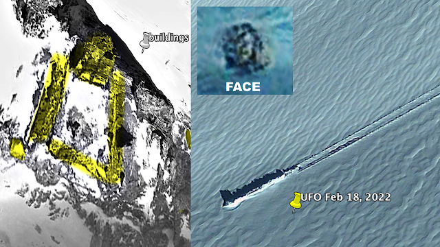


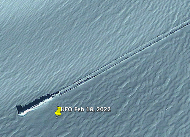


.jpg)


 Psyche asteroid that was once thought to be full of iron,...
 Final moments in the life of a dead planet seen for the...
 Meet the solar system's youngest asteroids! Pair of space...


.jpg)
.jpg)


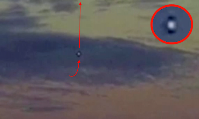

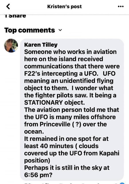


 From a 360-degree panorama of the dusty landscape to a...
 See Mars up-close! NASA Perseverance's high resolution...
 Last night's record-breaking fireball may have dropped a...