The purpose of this blog is the creation of an open, international, independent and free forum, where every UFO-researcher can publish the results of his/her research. The languagues, used for this blog, are Dutch, English and French.You can find the articles of a collegue by selecting his category. Each author stays resposable for the continue of his articles. As blogmaster I have the right to refuse an addition or an article, when it attacks other collegues or UFO-groupes.
Druk op onderstaande knop om te reageren in mijn forum
Zoeken in blog
Deze blog is opgedragen aan mijn overleden echtgenote Lucienne.
In 2012 verloor ze haar moedige strijd tegen kanker!
In 2011 startte ik deze blog, omdat ik niet mocht stoppen met mijn UFO-onderzoek.
BEDANKT!!!
Een interessant adres?
UFO'S of UAP'S, ASTRONOMIE, RUIMTEVAART, ARCHEOLOGIE, OUDHEIDKUNDE, SF-SNUFJES EN ANDERE ESOTERISCHE WETENSCHAPPEN - DE ALLERLAATSTE NIEUWTJES
UFO's of UAP'S in België en de rest van de wereld Ontdek de Fascinerende Wereld van UFO's en UAP's: Jouw Bron voor Onthullende Informatie!
Ben jij ook gefascineerd door het onbekende? Wil je meer weten over UFO's en UAP's, niet alleen in België, maar over de hele wereld? Dan ben je op de juiste plek!
België: Het Kloppend Hart van UFO-onderzoek
In België is BUFON (Belgisch UFO-Netwerk) dé autoriteit op het gebied van UFO-onderzoek. Voor betrouwbare en objectieve informatie over deze intrigerende fenomenen, bezoek je zeker onze Facebook-pagina en deze blog. Maar dat is nog niet alles! Ontdek ook het Belgisch UFO-meldpunt en Caelestia, twee organisaties die diepgaand onderzoek verrichten, al zijn ze soms kritisch of sceptisch.
Nederland: Een Schat aan Informatie
Voor onze Nederlandse buren is er de schitterende website www.ufowijzer.nl, beheerd door Paul Harmans. Deze site biedt een schat aan informatie en artikelen die je niet wilt missen!
Internationaal: MUFON - De Wereldwijde Autoriteit
Neem ook een kijkje bij MUFON (Mutual UFO Network Inc.), een gerenommeerde Amerikaanse UFO-vereniging met afdelingen in de VS en wereldwijd. MUFON is toegewijd aan de wetenschappelijke en analytische studie van het UFO-fenomeen, en hun maandelijkse tijdschrift, The MUFON UFO-Journal, is een must-read voor elke UFO-enthousiasteling. Bezoek hun website op www.mufon.com voor meer informatie.
Samenwerking en Toekomstvisie
Sinds 1 februari 2020 is Pieter niet alleen ex-president van BUFON, maar ook de voormalige nationale directeur van MUFON in Vlaanderen en Nederland. Dit creëert een sterke samenwerking met de Franse MUFON Reseau MUFON/EUROP, wat ons in staat stelt om nog meer waardevolle inzichten te delen.
Let op: Nepprofielen en Nieuwe Groeperingen
Pas op voor een nieuwe groepering die zich ook BUFON noemt, maar geen enkele connectie heeft met onze gevestigde organisatie. Hoewel zij de naam geregistreerd hebben, kunnen ze het rijke verleden en de expertise van onze groep niet evenaren. We wensen hen veel succes, maar we blijven de autoriteit in UFO-onderzoek!
Blijf Op De Hoogte!
Wil jij de laatste nieuwtjes over UFO's, ruimtevaart, archeologie, en meer? Volg ons dan en duik samen met ons in de fascinerende wereld van het onbekende! Sluit je aan bij de gemeenschap van nieuwsgierige geesten die net als jij verlangen naar antwoorden en avonturen in de sterren!
Heb je vragen of wil je meer weten? Aarzel dan niet om contact met ons op te nemen! Samen ontrafelen we het mysterie van de lucht en daarbuiten.
The breakthrough centers on the so-called Cryptic B manuscripts, two heavily damaged fragments labeled 4Q362 and 4Q363 that were long considered 'impossible' to read because they used an unfamiliar alphabet.
Researcher Emmanuel Oliveiro of the University of Groningen in the Netherlands determined that each cryptic symbol corresponded consistently to letters in Hebrew.
Once deciphered, the fragments revealed familiar biblical phrases and themes about the end of days, including divine judgment, the coming of a Messiah and the ultimate destiny of Israel.
Among the phrases is Yisrael (meaning 'Israel'), along with references to Judah, Jacob, and Elohim (meaning 'God').
While Cryptic A was successfully deciphered in 1955, Cryptic B remained a mystery for decades. Its strange symbols, inconsistent handwriting, and tiny surviving fragments made it exceptionally difficult to decode.
The Dead Sea Scrolls, uncovered in caves near the West Bank between 1947 and 1956, include some of the oldest surviving biblical manuscripts, written in Hebrew, Aramaic, and occasionally Greek
Only two manuscripts, 4Q362 and 4Q363, use this cipher exclusively, and many pieces of these texts are damaged, with some fragments measuring just a few millimeters across.
The surviving fragments are tiny, fragile and worn. The leather is cracked, darkened or frayed, and some pieces show margins, stitching holes or wrinkles.
Letters were written in black ink using fine- or medium-tipped pens, but their shapes, proportions, and spacing are inconsistent, with occasional corrections or double-tracing.
Overall, the manuscripts show significant variation both within each fragment and between the two texts, highlighting the irregular scribal execution of Cryptic B.
The content of 4Q362 appears religious in nature, employing several biblical idioms.
Fragment 21 references 'Elohim' and 'your glory,' while fragment 18 mentions 'the tents of Jacob,' echoing phrases found in Jeremiah 30:18 and Malachi 2:12.
In these passages, Judah also plays a role. Jeremiah 30:18, for instance, promises the restoration of Israel after judgment, with God bringing back their fortunes and rebuilding their cities, signaling hope and future renewal.
Malachi 2:12 warns against unfaithfulness in marriage, emphasizing the importance of remaining loyal to the Hebrew community.
The breakthrough centerson the so-called Cryptic B manuscripts, two heavily damaged fragments labeled 4Q362 and 4Q363 that were long considered 'impossible' to read because they used an unfamiliar alphabet. Pictured are pieces Pieces of Dead Sea Scroll with Cryptic B
Among the phrases is Yisrael, meaning 'Israel',' (PICTURED) along with references to Judah, Jacob, and Elohim (meaning 'God')
While 4Q362 does not directly quote these passages, its idiomatic language and thematic focus suggest an affinity with prophetic judgments and eschatological promises in biblical traditions.
The fragments also included references to dates and rulers.
For example, the use of 'the second year' and 'the fifth month' may reflect specific historical or prophetic dating conventions, similar to those found in other biblical and sectarian texts.
One of the most enigmatic features of 4Q362 is the mention of a grave in fragments 2 and 14.
While graves appear elsewhere in the Bible, none match the details described here. Oliveiro suggested that the word for 'signposts' in fragment 14 could also mean a tombstone, hinting at a possible connection.
4Q363 is even more fragmentary and difficult to interpret, as a repeated phrase appears twice, though it is unclear whether it refers to 'her daughters' or 'her villages.'
A common name, Benayahu, also appears, but its frequency in other texts prevents a precise identification.
Pictured is a fragments of 4Q363
The reason these messages were encoded remains uncertain, but Oliveiro proposed that the unusual scripts may have served a symbolic or ritual purpose.
By writing in an unfamiliar alphabet, the scribes could indicate that the content was intended for a select audience, such as priestly elites or scribal initiates, enhancing the text's sacred status without altering its meaning.
The complexity of Cryptic B lies less in the cipher itself, which is relatively simple, and more in the deliberate distortion of letter shapes, which made it appear undecipherable for decades despite containing no hidden or mystical messages.
Early humans may have feasted on Neanderthal children 45,000 years ago, according to a grisly new study.
Researchers have analysed bones found in a Belgian cave where cannibalism was known to have taken place.
Scientists find evidence that ancient humans ate children 850,000 years ago.
They revealed the six victims were children and young women who may have been cooked before being eaten.
And while the identity of the cannibals remains unknown, there's the possibility it could have been early Homo sapiens preying on rival Neanderthals, the scientists said.
The Goyet caves, first excavated in the 19th century, have yielded the most important collection of Neanderthals in northern Europe.
A 2016 study showed that a third of the 101 bones uncovered there – mainly from the lower limbs – showed traces of cannibalism with cut marks and notches.
'The composition – women and children, without adult men – cannot be coincidental: it reflects a deliberate selection of victims by the cannibals,' Isabelle Crevecoeur, research director at the French National Centre for Scientific Research, said.
'The fact that the cannibalized women and children came from elsewhere indicates "exocannibalism" – the consumption of individuals belonging to one or more external groups.'
The bones of at least six individuals were unearthed at the Goyet caves. Here, XX indicates the females – most likely adults or adolescents – while XY indicates the younger male children
The Goyet caves, first excavated in the 19th century, have yielded the most important collection of Neanderthals in northern Europe
The team combined genetics, isotope analysis and a detailed study of morphology to sketch a biological portrait of the cannibalised individuals.
Analysis of their DNA showed that the four adult or adolescent victims were women of small stature – around 1.5m tall – who were not from the local area. There were also two male children, one infant and one child between 6.5 and 12.5 years old.
A close look at their remains also showed evidence of circular impacts, made to break the bone in order to extract the highly calorific marrow.
All these indications have led to the conclusion that these Neanderthal women and children from elsewhere were brought to Goyet and consumed, the researchers said.
This type of behaviour is already observed in chimpanzees, with the purpose of weakening a neighbouring population or asserting territorial control.
'The Goyet site provides food for thought', Patrick Semal, another of the study's authors from the Royal Belgian Institute of National Sciences, said.
'The results indicate possible conflicts between groups at the end of the Middle Paleolithic, a period when Neanderthal groups were dwindling and Homo sapiens was in full expansion in Northern Europe.
'We cannot rule out that the cannibals were Homo sapiens, but we rather think they were Neanderthals. Some of the fragmented bones were also used to retouch stone tools, and this practice is known mainly among Neanderthals.'
An overview of the cannibalism marks found on the bones, with most appearing on the lower limbs (left) while cut marks and notches are clearly visible on these bones (right)
While the identity of the cannibals remains unknown, there's the possibility it could have been early Homo sapiens preying on rival Neanderthals Pictured: A reconstruction of the face of the oldest Neanderthal found in the Netherlands
Key events in Neanderthal and human history
300,000 years ago – Homo sapiens emerge in Africa
60,000 to 70,000 years ago – Homo sapiens migrate from Africa to Eurasia
50,500 to 43,500 years ago – Homo sapiens breed with Neanderthals
43,500 years ago – Neanderthals start to die out
Writing in the journal Scientific Reports the team said: 'At Goyet, the unusual demographic mortality profile of the cannibalised individuals (adolescent/adult females and young individuals) cannot be considered natural.
'Nor can it be explained solely by subsistence needs, especially given the abundant associated faunal remains that show similar butchery marks.
'At a minimum, it suggests that weaker members of one or multiple groups from a single neighbouring region were deliberately targeted.
'Although the precise causes of inter–group tensions in Pleistocene contexts remain difficult to establish, the regional chronocultural context is consistent with the hypothesis that conflict between groups played a role in the accumulation of the cannibalised individuals at Goyet.'
They said that even though Homo sapiens are not yet documented in the region at the same time as Neanderthals, there is evidence they were present at around the same time some 600km to the east in Germany.
And while the Homo sapiens predator hypothesis 'cannot be entirely ruled out', they said the most likely explanation for the cannibalism is conflict between Neanderthal groups.
Scientists have long speculated what caused the downfall of the Neanderthals, but a recent study suggests they never truly went extinct at all.
Scientists in Italy and Switzerland claim the ancient group of archaic humans didn't experience a 'true extinction' because their DNA exists in people today.
The timeline of human evolution can be traced back millions of years. Experts estimate that the family tree goes as such:
55 million years ago - First primitive primates evolve
15 million years ago - Hominidae (great apes) evolve from the ancestors of the gibbon
7 million years ago- First gorillas evolve. Later, chimp and human lineages diverge
5.5 million years ago - Ardipithecus, early 'proto-human' shares traits with chimps and gorillas
4 million years ago - Ape like early humans, the Australopithecines appeared. They had brains no larger than a chimpanzee's but other more human like features
3.9-2.9 million years ago- Australoipithecus afarensis lived in Africa.
2.7 million years ago- Paranthropus, lived in woods and had massive jaws for chewing
2.6 million years ago - Hand axes become the first major technological innovation
2.3 million years ago - Homo habilis first thought to have appeared in Africa
1.85 million years ago - First 'modern' hand emerges
1.8 million years ago - Homo ergaster begins to appear in fossil record
800,000 years ago- Early humans control fire and create hearths. Brain size increases rapidly
400,000 years ago - Neanderthals first begin to appear and spread across Europe and Asia
300,000 to 200,000 years ago - Homo sapiens - modern humans - appear in Africa
54,000 to 40,000 years ago - Modern humans reach Europe
Archaeologists have been very busy excavating lost civilizations, but they haven't found everything. There are still prominent ancient cities, including capitals of large kingdoms and empires, that have never been unearthed by scholars.
We know these cities exist because ancient texts describe them, but their location may be lost to time.
In a few cases, looters have found these cities, and have looted large numbers of artifacts from them. But these robbers have not come forward to reveal their location. In this countdown Live Science takes a look at six ancient cities whose whereabouts are unknown.
1. Irisagrig
Ancient inscriptions, some of them from Irisagrig, are on display at a ceremony where they were returned to Iraq. (Image credit: Win McNamee/Getty Images)
Not long after the 2003 U.S. invasion of Iraq, thousands of ancient tablets from a city called "Irisagrig" began appearing on the antiquities market. From the tablets, scholars could tell thatIrisagrig was in Iraq and flourished around 4,000 years ago.
Those tablets reveal that the rulers of the ancient city lived in palaces that housed many dogs. They also kept lions which were fed cattle. Those that took care of the lions, referred to as "lion shepherds," got rations of beer and bread. The inscriptions also mention a temple dedicated to Enki, a god of mischief and wisdom, and say that festivals were sometimes held within the temple.
Scholars think that looters found and looted Irisagrig around the time the 2003 U.S. invasion took place. Archaeologists have not found the city so far and the looters who did have not come forward and identified where it is.
2. Itjtawy
The remains of the pyramid of Amenemhat I at Lisht. The capital city he built has never been found, although scholars think that it is likely somewhere near Lisht. (Image credit: DeAgostini/Getty Images)
Egyptian pharaoh Amenemhat I (reign circa 1981 to 1952 B.C.) ordered a new capital city built. This capital was known as "Itjtawy" and the name can be translated as "the seizer of the Two Lands" or "Amenemhat is the seizer of the Two Lands." As the name suggests Amenemhat faced a considerable amount of turmoil. His reign ended with his assassination.
Despite Amenemhat's assassination, Itjtawy would remain the capital of Egypt until around 1640 B.C, when the northern part ofEgypt was taken over by a group known as the "Hyksos," and the kingdom fell apart.
While Itjtawy has not been found, archaeologists think it is located somewhere near the site of Lisht, in central Egypt. This is partly because many elite burials, including a pyramid belonging to Amenemhat I, are located at Lisht.
3. Akkad
A bust of Sargon of Akkad, an early ruler of the Akkadian Empire. (Image credit: Photo12/Universal Images Group via Getty Images)
The city of Akkad (also called Agade) was the capital of the Akkadian Empire, which flourished between 2350 and 2150 B.C. At its peak the empire stretched from the Persian Gulf to Anatolia. Many of its conquests occurred during the reign of "Sargon of Akkad," who lived sometime around 2300 B.C. One of the most important structures in Akkad itself was the "Eulmash," a temple dedicated to Ishtar, a goddess associated with war, beauty and fertility.
Akkad has never been found, but it is thought to have been built somewhere in Iraq. Ancient records indicate that the city was destroyed or abandoned when the Akkadian empire ended around 2150 B.C.
4. Al-Yahudu
A painting dating to 1830, which depicts Jewish exiles in the Babylonian empire. (Image credit: ARTGEN/Alamy)
Al-Yahudu, a name which means "town" or "city" of Judah, was a place in the Babylonian empire where Jews lived after the kingdom ofJudah was conquered by theBabylonian king Nebuchadnezzar II in 587 B.C. He sent part of the population into exile, a practice the Babylonians often engaged in after conquering a region.
About 200 tablets from the settlement are known to exist and they indicate that the exiled people who lived in this settlement kept their faith and used Yahweh, the name of God, in their names. Al-Yahudu's location has not been identified by archaeologists, but like many of these lost cities, was likely located in what is now Iraq. Given that the tablets showed up on the antiquities market, and there is no record of them being found in an archaeological excavation, it appears that at some point looters succeeded in finding its location.
5. Waššukanni
A cylinder seal from the Mitanni empire. It is now in the Metropolitan Museum of Art in New York City. (Image credit: Gift of Martin and Sarah Cherkasky, 1987; Metropolitan Museum of Art; Public Domain)
Waššukanni was the capital city of the Mitanni empire, which existed between roughly 1550 B.C. and 1300 B.C. and included parts of northeastern Syria, southern Anatolia and northern Iraq. It faced intense competition from the Hittite empire in the north and theAssyrian empire in the south and its territory was gradually lost to them.
Waššukanni has never been found and some scholars think that it may be located in northeastern Syria. The people who lived in the capital, and indeed throughout much of its empire, were known as the "Hurrians" and they had their own language which is known today from ancient texts.
6. Thinis
The Narmer palette, shown here, depicts King Narmer — also known as Menes — smiting an enemy. It dates back around 5,000 years ago to when Egypt was being unified. (Image credit: Werner Forman/Universal Images Group/Getty Images)
Thinis (also known as Tjenu) was an ancient city in southern Egypt that flourished early in the ancient civilization's history. According to the ancient writer Manetho, it was where some of the early kings of Egypt ruled from around 5,000 years ago, when Egypt was being unified. Egypt's capital was moved to Memphis a bit after unification and Thinis became the capital of a nome (a province of Egypt) during the Old Kingdom (circa 2649 to 2150 B.C.) period, Ali Seddik Othman, an inspector with the Egyptian Ministry of Tourism and Antiquities, noted in an article published in the Journal of Abydos.
Thinis has never been identified although it is believed to be near Abydos, which is in southern Egypt. This is partly because many elite members of society, including royalty, were buried near Abydos around 5,000 years ago.
Many fascinating discoveries and new insights into the curiosities of the ancient world have been unearthed throughout 2025.
Archaeological findings over the last 12 months have helped push back the timescales for ancient construction in Europe and elsewhere, while the unearthing of unique artifacts has added new clues to our understanding of ancient life. Additionally, several discoveries in 2025 have even helped bridge the gap between ancient history and mythology.
With such discoveries in mind, here’s a look at some of our favorite archaeological discoveries from 2025, and some of the greatest new insights we’ve obtained about the ancient world throughout the year.
A 4,000-Year-Old Labyrinth Rewrites an Ancient Myth
The unearthing of a massive, 4,000-year-old labyrinthine structure in Crete, hailed by researchers as among the most important finds of the century, captured headlines in 2025 as new details about the curious site, initially discovered in 2024, continue to emerge.
(Credit: Greek Ministry of Culture)
The accidental discovery, uncovered during excavations in advance of the construction of a new airport on the island, suggests that complex designs existed in the ancient world long before classical Greek accounts popularized the legend of the Minotaur and its famous labyrinth, potentially even offering support for there being at least some factual basis for the legendary structure’s existence.
A 5,000-Year-Old Spanish Tomb Reveals a Connected Ancient World
This year, the discovery of a 5,000-year-old tomb in Spain revealed unexpected evidence of long-distance cultural and material exchange in ancient Europe. Artifacts found at the site suggest that ancient communities were far more interconnected than previously assumed, sharing ideas, technologies, and symbolic practices across vast regions.
“The presence of seashells in an inland territory reflects the importance of the sea as an element of prestige and the existence of long-distance exchange networks,” explained Professor Juan Jesús Cantillo of the University of Cadiz, who was involved with the research.
Credit: University of Cadiz
Rather than isolated settlements, the tomb supports a growing view of prehistoric Europe as part of a dynamic, networked world—one in which trade routes and shared traditions linked distant populations centuries before written history.
Pompeii Continues to Yield Surprises
Excavations at Pompeii once again reshaped historians’ understanding of Roman life. This year, the intriguing placement stairway led archaeologists to evidence of a “lost” portion of the ancient city, thanks to modern 3D digital reconstructions that reveal how much of the ancient settlement was lost during the cataclysmic eruption of Mount Vesuvius and how it might have looked nearly 2000 years ago.
3D reconstruction of Pompeii’s ‘House of Thiasus’
(Image Courtesy of the Archaeological Park of Pompeii)
At the same time, new research into Roman concrete is helping to uncover how the material can seemingly self-heal over thousands of years. By decoding the chemical processes that underpin its durability, MIT scientists have gained insights not only into Roman engineering mastery but also into how ancient knowledge might inform modern sustainable construction.
Sunken Megaliths Off France Push Back Europe’s Timeline
Off the coast of France, archaeologists recently discovered a series of 7,000-year-old submerged megaliths, dramatically extending the known timeline of monumental stone construction in Europe. The finds suggest that large-scale architectural projects were underway centuries earlier than previously believed—and that rising sea levels may have hidden entire chapters of human history.
(Image Credit: SAMM, 2023/Yves Fouquet et al. / International Journal of Nautical Archaeology (2025))
“Also of intrigue is the fact that local legends bear some similarities to the recent discovery,” Ryan Whalen reported for The Debrief on December 14. “Specifically, a legend from around Brittany holds that, west of the Bay of Douarnenez, a drowned city known as Ys is believed to lie at the bottom of the ocean.”
Based on recent discoveries, archaeologists who published their work in the International Journal of Nautical Archaeology on December 9, 2025, believe the sunken structure could be related to traditional beliefs long associated with the region.
New Clues Near Stonehenge Challenge Old Assumptions
And finally, ongoing discoveries near the famous Stonehenge monument continue to offer new insights into Neolithic life in Britain. Among 2025’s major discoveries were a massive ring of ancient pits suggesting the presence of an ancient henge, and, more broadly, coordinated construction efforts on a scale not previously recognized, pointing to sophisticated social organization and long-term planning at the famous site.
A. Sood/Unsplash)
Meanwhile, research into the enigmatic Newall boulder overturned the idea that glaciers transported the stone to the site, instead revealing a far more deliberate human role in its placement. Together, the findings reinforce the view that Stonehenge was part of a much larger, carefully designed ceremonial landscape.
Micah Hanks is the Editor-in-Chief and Co-Founder of The Debrief. A longtime reporter on science, defense, and technology with a focus on space and astronomy, he can be reached atmicah@thedebrief.org. Follow him on X @MicahHanks, and at micahhanks.com.
A collection of silver coins sold on the black market has led Europeanarchaeologiststo the discovery of a monumental prehistoric fortress.
The 3000-year-old site, hidden away in the Papuk Mountains of eastern Croatia, presents previously unknown evidence of complexfortifications that once existed in the region.
Located 611 meters above sea level, the Gradina site was discovered after reports involving the illegal excavation of “silver coins from Voćin” began surfacing amid Europe’s illicit antiquities markets. Efforts to track down information about the looted coin hoard ultimately helped lead archaeologists to the long-overlooked Croatian site.
Excavations Underway
Currently, excavations at the site are being led by Hrvoje Potrebica, a professor of prehistoric archaeology at the University of Zagreb. Working with colleagues, including researchers Franka Ovčarić and Luka Drahotusky-Bruket, systematic surveys and initial excavations at the site revealed the presence of stone ramparts and other features.
The site is now believed to potentially be one of the best-preserved prehistoric settlements ever uncovered in the region.
“These are some of the most visible ramparts, very well preserved, of a prehistoric settlement in this part of Croatia,” Potrebica said in a statement.
“Usually they were built of earth and wood, so they fell into disrepair,” Potrebica added, “but here it is different.”
An Ancient Site Emerges
Initial assumptions suggested the site dated to the La Tène culture of the late Iron Age, around the 1st century BCE, consistent with the Celtic silver coins first linked to the area.
That all began to change for Potrebica and his colleagues as their investigations continued, revealing discoveries that hinted at a much deeper origin for the ancient site. These included ceramic fragments the team uncovered, dating to the Late Bronze Age, roughly 1200 to 1000 BCE.
“These findings are very rare,” Potrebica said, adding that the ancient fortress structure encloses an area estimated to comprise four hectares.
“At one point we decided to cut through the rampart, and we established a monumental construction consisting of three layers, earth, stone, and rammed earth, up to 2 meters high, in some places 7 to 8 meters on the outside,” Potrebica said.
A Remarkably Well-Preserved Site
In some sections, the archaeologists also uncovered a dry-stone defensive wall more than 1.5 meters thick, an exceptional level of preservation for prehistoric fortifications in this part of Europe.
Most prehistoric settlements in the region relied on perishable materials, including earth and timber defenses, and thus have largely deteriorated over time. The stone-built ramparts at Gradina, by contrast, remain clearly visible on the landscape, marking the site as a significant outlier.
This suggests a level of organization exhibited by its ancient builders, the likes of which had never been documented previously in the region during this period. Additionally, evidence of domestic structures and other signs of daily life point to its apparent use as a long-term habitation site.
“Here, at this place, we did not expect anything like this,” Potrebica said, adding that the team’s discoveries were unlike anything he had encountered in his profession in the last quarter century.
Fundamentally, the site’s rediscovery underscores both the scientific potential—and the risks—associated with illicit antiquities trafficking. Although illegal looting by metal detectorists at the site helped lead to its discovery, such activities also destroyed the original archaeological context of the artifacts removed.
Nevertheless, in this case, the removal and eventual black-market sale of coins from the ancient site led archaeologists to a novel discovery—one that is expanding our knowledge of the region’s inhabitants’ activities long before Roman or medieval times.
For Potrebica, the discoveries his team has made during their excavations are truly one of a kind.
“I have never seen anything like this,” Potrebica said.
Additional details about the team’s discovery, along with photos of the ancient site, can be found here courtesy of vpz.hr and Kristijan Toplak.
Micah Hanks is the Editor-in-Chief and Co-Founder of The Debrief. A longtime reporter on science, defense, and technology with a focus on space and astronomy, he can be reached atmicah@thedebrief.org. Follow him on X @MicahHanks, and at micahhanks.com.
These ancient cities were built underground — and no one knows exactly why
These ancient cities were built underground — and no one knows exactly why
Some ancient cities were carved deep below the Earth to house thousands — but no one can say for sure why they were built, or what they were hiding from.
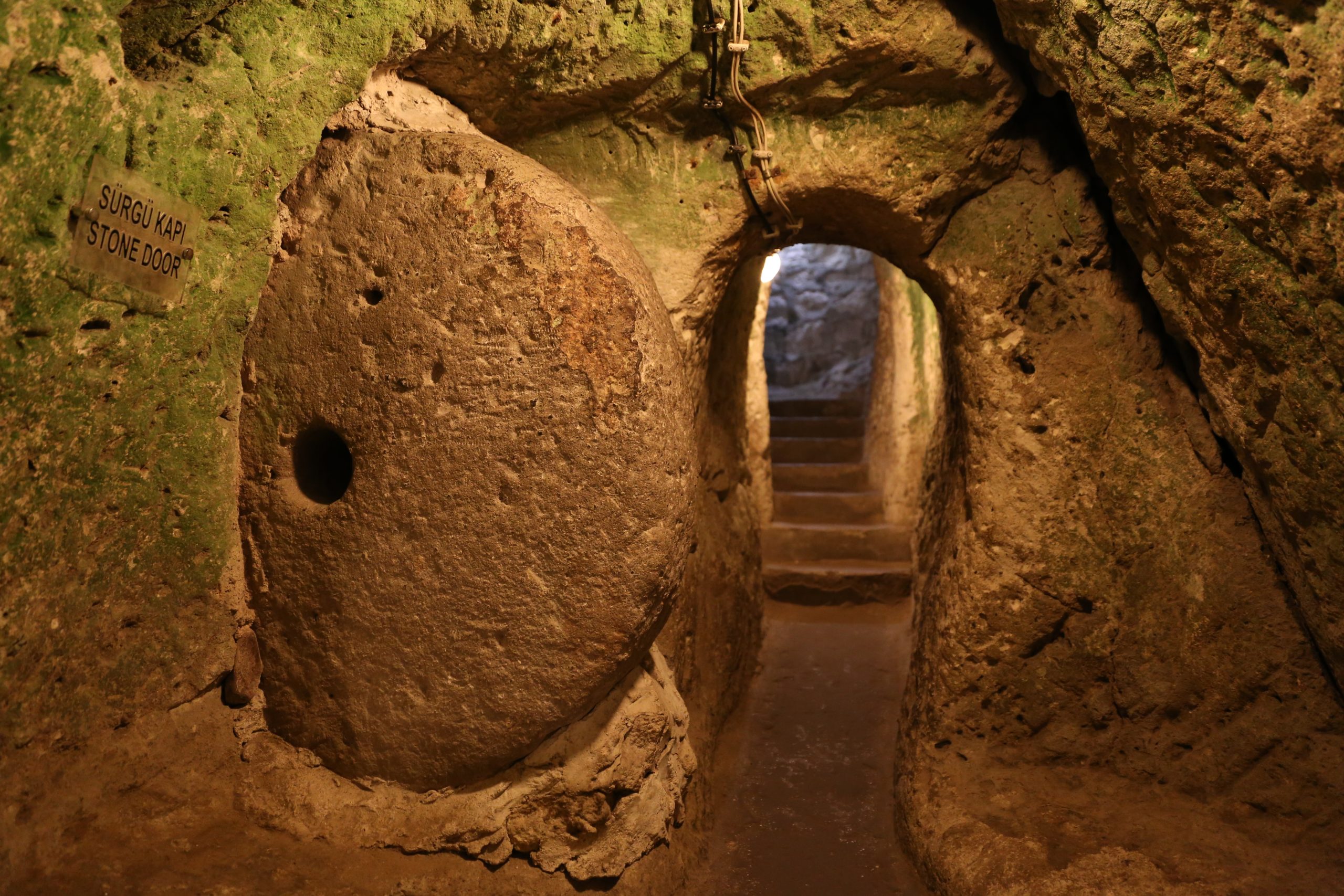
Derinkuyu Underground City in Cappadocia, Nevsehir, Turkey
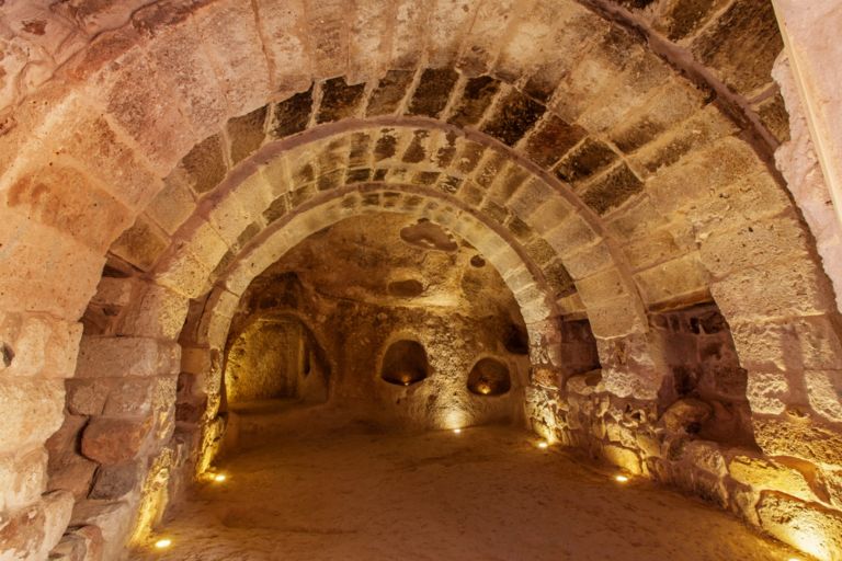
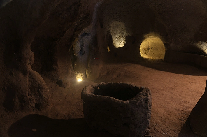
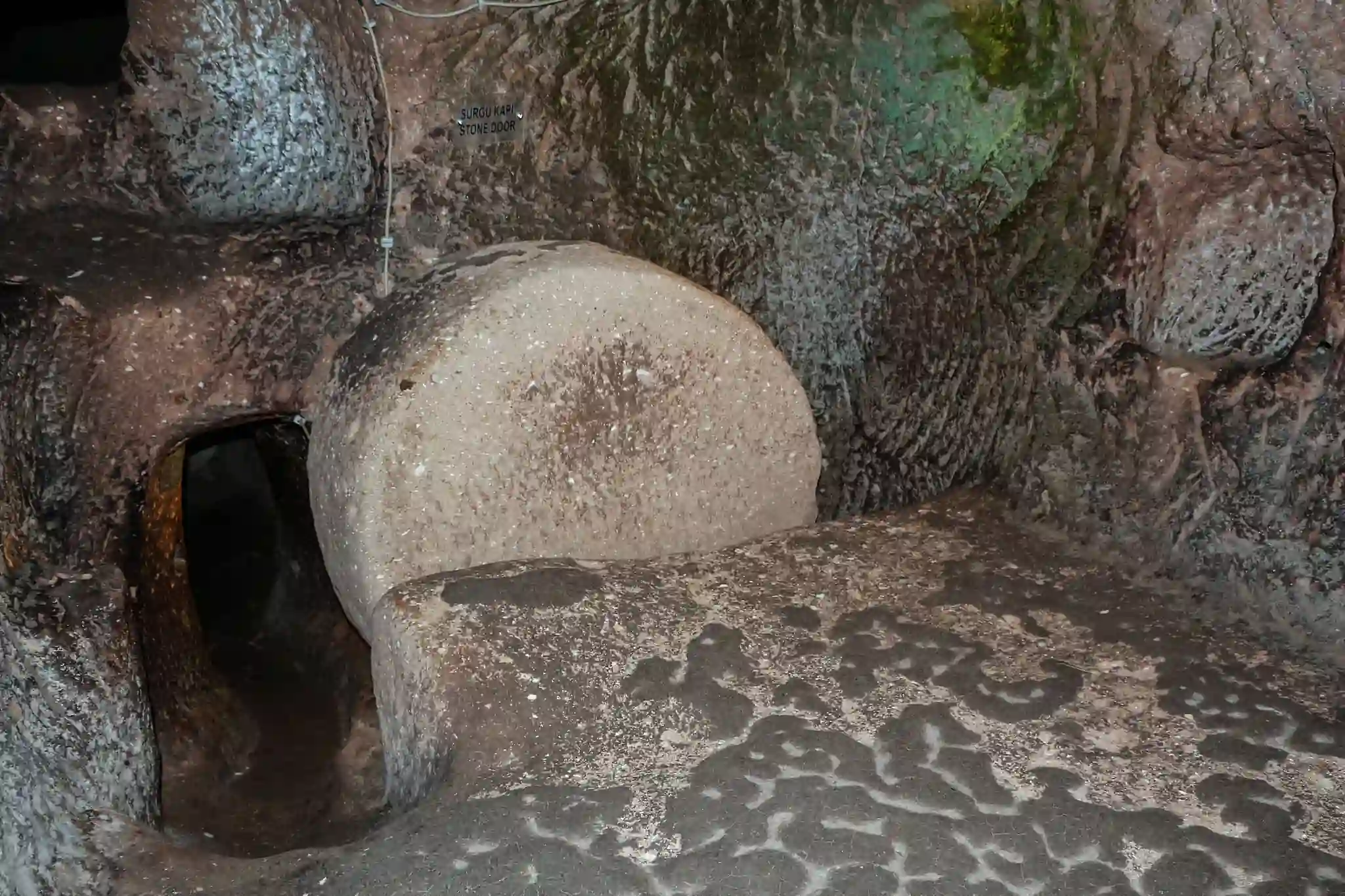
Long before steel and concrete-shaped skylines, entire cities were carved deep below the Earth. These were not just emergency shelters — these were fully developed with food storage, schools, temples, and homes. Mind-boggling ancient cities. One could hold over 20,000 people. But despite decades of research, no one knows exactly why they were built. Were they designed to protect from war, climate disaster, or something more mysterious? These hidden cities remain one of archaeology’s most enduring riddles.
Derinkuyu: A vast city buried beneath Cappadocia
In central Turkey’s Cappadocia region, the ancient city of Derinkuyu plunges 18 stories below ground. Discovered by accident in 1963 when a homeowner knocked down a wall and found a hidden room behind it, Derinkuyu revealed an enormous underground complex — complete with kitchens, wine presses, churches, ventilation shafts, and even livestock pens.
Tunnels in the ancient underground city of Derinkuyu.
At its peak, Derinkuyu could accommodate more than 20,000 people. Stone doors could seal off sections of the city in case of invasion, and long vertical shafts provided fresh air to the deepest levels. The earliest sections may date back to around 800 BCE, with possible Hittite origins, though some scholars argue it could be even older. It was later expanded and used by early Christians fleeing persecution.
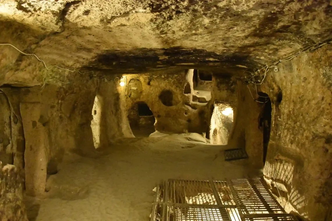
Kaymakli: A connected city beneath the stone
A room in the underground city of Kaymakli. Wikimedia commons.
Not far from Derinkuyu lies Kaymakli, another underground settlement likely connected by tunnels to its larger neighbor. Unlike the vertical structure of Derinkuyu, Kaymakli spreads out horizontally, with a maze of rooms across at least five known levels — though many believe there are more yet to be discovered.
Kaymakli was designed for community living, with homes, kitchens, storage areas, and stables all organized into clusters. Its structure suggests it was built not just for hiding, but for long-term habitation. Most experts date its active use to the Byzantine era, especially during times of regional conflict, but some of the rock-cut foundations could be much older.
Mazı: A hidden vertical city carved into the rock
Mazı is a lesser-known but equally fascinating example of ancient underground cities in the Cappadocia region. Unlike the more spacious layouts of Derinkuyu or Kaymakli, Mazı is a vertical settlement, built deep into the volcanic stone with narrow passageways, hidden doors, and steep staircases.
The underground city of Masi. Credit httpsmuze.gov.tr
Its design suggests a focus on defense. Invaders could be slowed or trapped in tight corridors, while residents could escape or defend themselves using hidden exits and small observation holes. Archaeological evidence links Mazı to the Roman or early Christian period, but the full timeline of its use is still uncertain.
Özkonak: Engineered for siege survival
Located in northern Cappadocia, Özkonak may be smaller than Derinkuyu, but it features some of the most sophisticated defense features ever found in ancient cities. Built with narrow shafts that allowed residents to pour boiling oil or water on attackers, it also had communication pipes that ran between levels — a rare feature not seen in other sites.
One of the doors inside the underground city of Özkonak. Wikimedia commons.
Only four levels of Özkonak have been excavated so far, but archaeologists believe there are deeper chambers waiting to be uncovered. Like many of Cappadocia’s subterranean settlements, the exact age of Özkonak is still debated, though its structure suggests it was built with long-term survival in mind.
Tatlarin: A mysterious city still under excavation
Tatlarin is one of the lesser-explored ancient cities in the region. Located near Nevşehir, it features a chapel, storage rooms, and stables — all carved into the rock. Unlike the larger underground complexes, Tatlarin remains only partially excavated, and much of it is still hidden beneath the surface.
One of the rooms of the underground city of Tatlarin. Credit: www.turkishmuseums.com/
Its layout and architecture suggest it may have served both residential and religious purposes. The lack of large-scale tourism or full excavation gives Tatlarin a unique role in understanding the broader underground building tradition in ancient Anatolia.
Why were entire cities built underground?
I believe that the real mystery behind these ancient cities isn’t just their size, but the decision to build them underground at all. Excavating stone, carving tunnels, and creating entire living systems beneath the surface was no small task. It required time, planning, and purpose.
Some historians believe the cities were designed as defensive strongholds, built to protect people from invasions during unstable periods. With hidden entrances, stone doors, and narrow corridors that could be easily defended, the idea holds weight. Others argue that the underground environment offered relief from extreme weather or natural disasters, allowing communities to survive in harsh conditions.
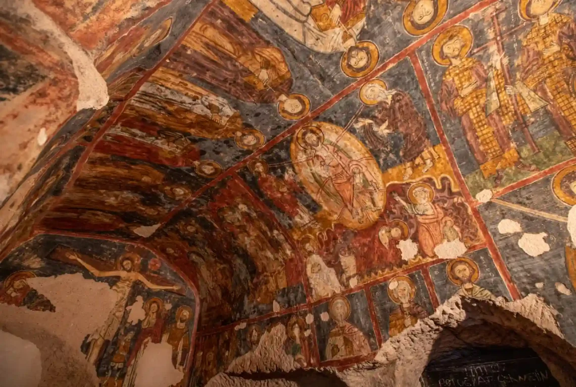
There is also evidence of religious use. In many of these cities, archaeologists have found chapels, altars, and Christian symbols carved into the rock. This suggests they may have served as places of refuge during times of persecution, particularly in the early centuries of Christianity.
Still, these explanations only go so far. The scale of some cities, with facilities for wine production, animal shelters, and food storage, points to long-term habitation. They were not simple hideouts. They were meant to sustain life.
Perhaps the true answer is a combination of factors, or perhaps we are still missing the bigger picture. Until more evidence comes to light, the reasons why these ancient cities were built underground will remain one of the most compelling questions in archaeology.
Archeologists have unearthed the remains of a 4,500-year-old Egyptian temple where visitors would sky-gaze while on the roof.
The building's remains were found at Abu Ghurab, about nine miles south of the Egyptian capital Cairo and five miles west of the River Nile.
A 'huge' building exceeding 10,000 sq ft (1,000 square metres), the temple was dedicated to the deity Ra, the sun god and father of all creation.
It was constructed on the orders of Pharaoh Nyuserre Ini, who reigned from approximately 2420 BC to 2389 BC during Egypt's Fifth Dynasty.
According to Egypt's Ministry of Tourism and Antiquities, it had a public calendar of religious events carved into blocks and a roof for astronomical observation.
Photos show several well-persevered elements recovered from the site, including wall fragments featuring hieroglyphics and shards of pottery.
'With a unique architectural plan, it makes it one of the largest and most prominent temples of the valley,' the ministry said in a translated Facebook post.
'Carved stone fragments of fancy white limestone are also found, alongside large quantities of pottery.'
The lost Egyptian temple about 10 miles south of Cairo has been unearthed 4,500 years after it was built in honour of the sun god Ra
The roof of the valley temple was probably used for astronomical observations, according to archaeologists from Italy who led the expedition
The site was identified as early as 1901 by the German archaeologist Ludwig Borchardt, but groundwater levels were too high for excavations to be carried out.
But the latest excavations, which commenced in 2024, have uncovered more than half of the temple, previously buried under sediment, the ministry said.
Work there has revealed the entrance of the temple, including the original entrance floor and the remains of a circular granite column, likely part of the entrance's porch.
Portions of the original stone cladding of the corridor walls have also been unearthed, as well as a number of architectural elements such as granite shingles and doors.
The mission has also discovered the remains of an internal staircase leading to the roof in the northwestern part of the temple – likely a secondary entrance – and a slope believed to have linked the temple to the Nile or one of its branches.
'The roof of the valley temple was probably used for astronomical observations but not for the celebration of the festivals,' Massimiliano Nuzzolo, an archaeologist and excavation co-director, told Live Science.
Meanwhile, the lower level was 'used as a landing stage for the boats approaching it from the Nile or, more likely, from one of its side channels'.
The expedition also found a distinctive collection of artifacts, including two wooden pieces of the ancient Egyptian 'Senet' game, resembling modern chess.
The ancient Egyptians enjoyed playing board games, archeological remains of playing piece fragments show, including 'Senet' resembling modern chess
Photo show several well-persevered elements recovered from the site, including wall fragments featuring hieroglyphics and shards of pottery
Who was Nyuserre Ini?
Nyuserre Ini was a pharaoh of Egypt’s Fifth Dynasty who ruled around 2450 BC during Egypt’s Old Kingdom.
He is best known for his devotion to the sun god Ra and for building the magnificent Sun Temple at Abu Gurab and his pyramid complex at Abusir.
His reign was marked by peace, prosperity, and artistic innovation.
'The sanctuary thus became a dwelling and one of the favourite local [games] was probably playing senet,' Nuzzolo added.
Preliminary studies indicate that the temple, after ending its role as a place of worship, was transformed into a small residential area inhabited by locals.
Further excavation work at the site could reveal more about its history before it was smothered by sediment from the Nile.
'The mission is preparing to continue its work in the coming seasons to explore more elements of this important archaeological site,' the ministry statement added.
'Removing the curtain on new details [will] add much to understanding the origin and evolution of the Sun Temples in ancient Egypt.'
Known for his devotion to the sun god, Pharaoh Nyuserre Ini was the sixth of nine kings who reigned during Egypt's Fifth Dynasty, which ruled Egypt for about 150 years.
The Fifth Dynasty pharaohs closely identified themselves with Ra, building temples in the deity's honour.
Hieroglyphic inscriptions found in the valley temple include a public calendar detailing religious events
The mission has first succeeded in uncovering more than half the temple, where a huge building exceeding 1000 square meters appeared
According to the belief at the time, Ra was the king of the deities and the father of all creation, as well as the deity who governed the actions of the sun.
The Egyptians were an agricultural society living in a desert, so not surprisingly, the sun – and thereby Ra – was an integral component of their cosmos, guiding their thoughts and actions.
Egyptians in this region relied on the sun and the Nile and the rich, fertile soil that surrounded the river for sustenance, such as bread, beer and vegetables.
Beer was not simply a staple food for the living, but 'a symbol of status and authority', important in elite feasting and burial rituals 'in this life and the next'.
It would have been 'a thick porridge' – likely cloudy and sweet with a low alcoholic content – that was mostly made from wheat, barley and grass.
WHAT DO WE KNOW ABOUT THE FIFTH DYNASTY OF EGYPT?
Pharaohs of the Fifth Dynasty ruled for around 150 years from the early 25th century BC to the middle of the 24th century BC.
The succession of the kings during this period isn't certain as there is contradicting evidence about who ruled during certain periods but the dynasty is known for a number of achievements, including sun temples.
Every pharaoh in the Fifth Dynasty is thought to have built one with the exception of the last two rulers.
Pyramid Texts, thought to be the earliest known type of ancient Egyptian religious text, also came around towards the end of the dynasty under king Unas.
The number of high officials also increased during this period as the positions were no longer restricted to royal family members.
More than 3,000 years after they were damaged by an earthquake, two of Egypt's most breathtaking monuments have been handsomely restored.
The Colossi of Memnon are two giant alabaster statues on the other side of the Nile from Luxor, the historic city in Upper Egypt.
Each measuring nearly 50 feet in height, they represent Amenhotep III, the powerful pharaoh who ruled ancient Egypt from 1391 to 1353 BC.
On Sunday, authorities pulled back the curtain on the repaired statues, described as 'one of the most important landmarks of the Egyptian civilization'.
They have been restored, reassembled and raised to their original place as part of a renovation project that's lasted around two decades.
Amenhotep III ruled ancient Egypt at the height of its powers, was worshipped as a living god, and was the grandfather of Tutankhamun.
Michael Habicht, an archaeologist at Flinders University in Australia, said he 'promoted peace and lived in a time of the greatest economic prosperity'.
'He might well have been one of the richest men that ever lived, at least in his epoch,' he said.
The giant alabaster statues, known as the Colossi of Memnon, were reassembled in a renovation project that lasted about two decades
Each measuring nearly 50 feet in height, they represent Amenhotep III, the powerful pharaoh who ruled ancient Egypt about 3,400 years ago
The Colossi of Memnon were originally built in 1350 BC, made from blocks of quartzite sandstone quarried near modern-day Cairo and transported 420 miles.
Both statues depict Amenhotep III seated with hands resting on his thighs, with their faces looking eastward toward the Nile and the rising sun.
They wear the striped 'nemes' headdress surmounted by the double crowns and the pleated royal kilt, which symbolizes the pharaoh's divine rule.
Two other small statues on the pharaoh's feet depict his wife, Tiye, while more than 100 inscriptions cover the Colossi in Greek and Latin.
In about 1200 BC, the colossi were damaged by a strong earthquake that also destroyed Amenhotep III's nearby funerary temple.
The statues were fragmented and partly quarried away, with their pedestals dispersed.
Some of their blocks were reused in Luxor's Karnak temple, but archaeologists brought them back to rebuild the colossi, according to the Antiquities Ministry.
The colossi are of great significance to Luxor, a city known for its ancient temples and other antiquities and one of the oldest continuously inhabited cities in the world.
The Colossi of Memnon were originally built in 1350 BC, made from blocks of quartzite sandstone quarried near modern-day Cairo and transported 420 miles
In late 1990s, an Egyptian German mission, chaired by German Egyptologist Hourig Sourouzian, began working in the temple area, including the assembly and renovation of the colossi
Pictured, visitors take photos with the two giant reassembled alabaster statues of Pharoah Amenhotep III, in the southern city of Luxor, Egypt, Sunday, December 14, 2025
Who was Amenhotep III?
Amenhotep III is one of the most important kings of the Eighteenth Dynasty who built or rebuilt many temples in the country (Luxor, Memphis, Elkab, Armant).
At Thebes he had a vast temple constructed to his own cult on the West Bank; the colossal statues (known as the Colossi of Memmon, before the entrance) are the most monumental elements still standing.
The king issued a number of scarabs with longer inscriptions describing events of his reign.
His main wife was Tiy, who seems to have played an important part in the reign. She appears on monuments more often and more prominently than virtually any queen before her.
Source: UCL
They´re also an attempt to 'revive how this funerary temple of king Amenhotep III looked like a long time ago', said Mohamed Ismail, secretary-general of the Supreme Council of Antiquities.
Amenhotep III, one of the most prominent pharaohs, ruled during the 500 years of the New Kingdom, which was the most prosperous time for ancient Egypt.
The pharaoh, whose mummy is showcased at a Cairo museum, ruled between 1390-1353 BC, a peaceful period known for its prosperity, prosperity and grandeur.
'Diplomatic letters by foreign potentates begged him to send them some gold as a present, "as gold shall be abundant in Egypt as sand",' Dr Habicht said.
'It's the usual over-exaggeration for such a letter, but nevertheless hints towards extreme wealth.'
According to the academic, the pharaoh may also have been something of a womanizer, importing hundreds of foreign women to be part of his harem.
'He was apparently very interested in women; he imported hundreds of foreign harem ladies and collected them as other people collect postal stamps,' he said.
Amenhotep III's reign was also known for great construction, including his mortuary temple, where the Colossi of Memnon are located, and another temple, Soleb, in Nubia.
Amenhotep III, one of the most prominent pharaohs, ruled during the 500 years of the New Kingdom, which was the most prosperous time for ancient Egypt
Unlike other monumental sculptures of ancient Egypt, the colossi were partly compiled with pieces sculpted separately, which were fixed into each statue´s main monolithic alabaster core, the ministry said
He is thought to have died between the ages of 40 and 50, leaving his successor (son Akhenaten IV) a kingdom at the height of its power and wealth.
Amenhotep IV would rebel against the powerful Amun priesthood, installing the sun god Aten as the top Egyptian deity.
He changed his name to Akhenaten – meaning 'beneficial to Aten' – and even moved his capital away from Thebes – the 'city of Amun' – to a new city honouring the sun god, Akhetaten.
But his son, Tutankhaten, would restore the cult of Amun to prominence, changing his name to Tutankhamun – meaning 'the living image of Amun'.
Tutankhamun would become one of history's most famous pharaohs thanks to the discovery of his tomb in 1922, which was largely intact and contained many of its original artifacts.
The complex family arrangements of Tutankhamun has been one of the great mysteries surrounding the young king.
While his father was known to have been Pharaoh Akhenaten, the identity of his mother has been far more elusive.
DNA testing has shown that Queen Tiye, whose mummy is pictured above, was the grandmother of the Egyptian Boy King Tutankhamun
In 2010 DNA testing confirmed a mummy found in the tomb of Amenhotep II was Queen Tiye, the chief wife of Amenhotep III, mother of Pharaoh Akhenanten, and Tutankhamun's grandmother.
A third mummy, thought to be one of Pharaoh Akhenaten wives, was found to be a likely candidate as Tutankhamun's mother, but DNA evidence showed it was Akhenaten's sister.
Later analysis in 2013 suggested Nefertiti, Akhenaten's chief wife, was Tutankhamun's mother.
However, the work by Marc Gabolde, a French archaeologist, has suggested Nefertiti was also Akhenaten's cousin.
This incestuous parentage may also help to explain some of the malformations that scientists have discovered afflicted Tutankhamun.
He suffered a deformed foot, a slightly cleft palate and mild curvature of the spine.
However, his claims have been disputed by other Egyptologists, including Zahi Hawass, head of Egypt's Supreme Council of Antiquities.
His team's research suggests that Tut's mother was, like Akhenaten, the daughter of Amenhotep III and Queen Tiye.
Hawass added that there is 'no evidence' in archaeology or philology to indicate that Nefertiti was the daughter of Amenhotep III.
An ancient cube-shaped skull unearthed in Mexico is rewriting our understanding of the ancient world, revealing a completely unique member of a society from 1,400 years ago.
This remarkable skull belonged to a man over 40 years old who lived during Mexico's Classic period, roughly between 400 and 900 AD, according to specialists from the National Institute of Anthropology and History (INAH).
Researchers determined through bone and teeth analysis that the man was born, lived his entire life, and died right there in the local mountains, with no evidence he ever moved or lived in another region.
The team added that the find was 'unprecedented' in this part of the world as a skull deformed to resemble a cube had never been found near Huasteca before.
The skull's unique appearance was the result of intentional cranial deformation, a practice where flat boards and bandages were pressed against a baby's soft head for years to mold it into a square shape.
This deformation was likely done without causing pain, as the skull bones of an infant are malleable, allowing families to gradually reshape the head as a cultural tradition.
Experts believe such rituals were performed to signify beauty, social status, or even spiritual connections in ancient Mesoamerican societies.
Researchers in Mexico have discovered a man's skull which was deformed to take the shape of a cube roughly 1,400 years ago (Pictured)
The skull was found at the Balcón de Montezuma archaeological site in the northern Huasteca region of Mexico's Tamaulipas state
Archaeologists have previously uncovered a variety of intentionally modified skulls across ancient Mexico, particularly elongated cone-like shapes among the Olmec and Maya.
Those cone-shaped skull changes are believed to have been achieved by gently binding infants' soft heads with cloth and bandages during the first months or years of their lives.
To the ancient Mesoamericans, these oddly-shaped skulls held a different significance depending on the ancient civilization making the changes to their babies. For example, the ancient Maya are believed to have done this for social status and beauty.
However, the newly discovered cube skull has left researchers with a mystery, as the team from INAH could not explain why this man was the only human to undergo this procedure in Tamaulipas.
Cube-shaped skulls, with their flattened tops that create a boxy profile, have typically been found at distant sites like El Zapotal in Veracruz and scattered Maya settlements in southeastern Mexico, far from the northern mountains where this fossil turned up.
With that in mind, the research team decided to test if the 40-year-old was truly a native of the northern Huasteca region.
Scientists looked at specific clues hidden in his bones and teeth. These clues are called 'stable oxygen isotopes,' or different versions of oxygen atoms that don't change over time.
The exact mix of these oxygen versions in bones and teeth come from the water a person drinks throughout their life.
The research team was able to confirm that this man spent his entire life in the region, making his cube-shaped skull more of a mystery since this ritual was unusual for the area
Water in different places, such as in rainy mountains or dry coasts, has its own unique oxygen 'fingerprint' because of the local climate and geography.
By testing those oxygen fingerprints in the man's tooth enamel, which formed in childhood, and bone collagen, which updates through adulthood, researchers saw the same mountain water pattern in both.
That made it a match for the local mountain water this person likely drank his whole life in Mexico's northern mountains.
Physical anthropologist Jesús Ernesto Velasco González said: 'Stable oxygen isotope studies in collagen and bioapatite samples from bone and teeth, a technique used to infer the geographic origin of the second individual's skeletal remains, indicate that he was born, lived, and died in this part of the mountains.'
'Therefore, the results rule out a direct mobility relationship with the groups of El Zapotal or those further south,' the researcher continued in a statement translated to English.
While the team is still trying to crack the mystery behind the cube-shaped skull, they said it likely wasn't just about looking different, but may have been a symbol of belonging to a larger cultural family that stretched across hundreds of miles of Mexican coastline.
A new discovery has rewritten the timeline of Egypt's early dynasties, placing the rise of the New Kingdom nearly a century later than previously thought.
The New Kingdom, which lasted from 1550 to 1070 BCE, was Egypt's peak of power, wealth, and territorial expansion, the era of famous rulers like Tutankhamun.
It began with the 18th Dynasty, founded by Pharaoh Ahmose I, who reunited Egypt and expelled the Hyksos invaders, restoring central authority after a period of fragmentation.
Now, scientists have confirmed that the massive Santorini (Thera) volcanic eruption occurred before the reign of Ahmose, meaning the 18th Dynasty, and the New Kingdom itself, rose later than previously believed.
Until now, historians had often assumed the eruption might have coincided with the early New Kingdom, and some researchers even tried to link it to specific pharaohs, including Hatshepsut, Thutmose III or Ahmose I.
The breakthrough comes from radiocarbon dating of Egyptian artifacts from the 17th and early 18th Dynasties.
Researchers examined a mudbrick stamped with Ahmose's name, a linen burial cloth, and wooden funerary figures called shabtis, all of which were directly tied to known pharaohs and their temples.
Because these objects are anchored to specific historical contexts, their ages provide a reliable snapshot of the period. The study shows that the eruption predates these artifacts, reshaping how historians understand the rise of Egypt's most powerful period.
By reanalyzing ancient Egyptian artifacts, like a brick stamped with a pharaoh's seal, scientists were able to change the timeline
Scientists have confirmed that the massive Santorini (Thera) volcanic eruption occurred before the reign of Ahmose, meaning the 18th Dynasty, and the New Kingdom itself, rose later than previously believed
The Santorini volcano, located about 75 miles north of Crete, is surrounded by the small islands of Thera, Therasia, and Aspronisi.
Over time, it has produced many large, explosive eruptions, but the most famous occurred during the Late Minoan IA period, around 1600 to 1480 BC.
This eruption buried the town of Akrotiri on southern Thera under thick layers of volcanic ash.
Fine ash was carried by winds and fell as far away as eastern Crete, demonstrating the eruption's enormous regional impact.
Traditionally, the Thera eruption has been linked to Egypt's 18th Dynasty, with scholars using it as a rough marker for dating early New Kingdom events.
However, the new radiocarbon analysis showed the eruption actually occurred earlier, during the Second Intermediate Period, a time before Egypt had fully reunited under Ahmose.
This means that previous assumptions tying the eruption directly to the early New Kingdom were incorrect.
'This study provides the first direct radiocarbon comparison between the Thera eruption and Egyptian artifacts from this transitional period,' said the researchers from Ben-Gurion University of the Negev and the University of Groningen.
Researchers examined a mudbrick stamped with Ahmose's name, a linen burial cloth, and wooden funerary figures called shabtis (pictured), all of which were directly tied to known pharaohs and their temples
'It allows us to anchor one of the most dramatic natural events in the eastern Mediterranean to Egypt's own historical timeline for the first time.'
The findings carry broader implications for our understanding of the ancient world.
By showing that the eruption happened earlier than previously thought, historians and archaeologists can now reassess cultural and trade interactions between Egypt, Crete, and other Mediterranean regions.
This includes everything from the movement of goods and ideas to migrations prompted by natural disasters.
The research also demonstrated the power of modern science to reshape what we know about ancient history.
Even civilizations studied for thousands of years, like Ancient Egypt, can have their timelines refined through new techniques and careful analysis.
The results support the 'low chronology' model, which positions the start of the 18th Dynasty a bit later than previously thought.
Photograph published in 1916, showing four 12th Dynasty shabtis and one shabti attributed by him to the 17th Dynasty
Pictured is the Khufu Pyramid, also known as the Great Pyramid, in Giza Pyramid Complex.
As lead author Hendrik J Bruins put it, “Our findings indicate that the Second Intermediate Period lasted considerably longer than traditional assessments, and the New Kingdom started later.”
Although the adjustment is modest in years, it carries major historical significance.
Ahmose’s reunification of Egypt marks a critical turning point, and moving its date reshapes how scholars understand the political and cultural transformation that ushered in Egypt’s New Kingdom.
Scientists studying Romanconcrete used 2,000 years ago to constructbuildings, bridges, and other structures that possess a remarkable ability to last through the centuries have found evidence that ancient Rome’s artisans used advanced technology to create the material.
The researchers also characterized several reactive materials, includingvolcanic ash from Mount Vesuvius, that were used to reinforce Roman concrete’s self-healing ability, including several bridges and other structures that are still in use today.
“With this paper, we wanted to clearly define a technology and associate it with the Roman period in the year 79 C.E.,” explained MIT Associate Professor Admir Masic.
How ‘Hot Mixing’ Gave Roman Concrete its Self-Healing Properties
According to a press release announcing the research, the first person to document the process of making Roman concrete was Vitruvius in his 1st-century BCE text “De architectura.” Although the ancient text is considered the first known book to discuss architectural theory, the process it describes for mixing Roman concrete has created a modern-day controversy.
Caesarea Roman concrete bath ruins (Image credit: James Cocks, www.jamescocks.com/Wikimedia/CC 3.0)
According to Vitruvius, the Romans added water to lime to create a concrete predecessor. After this step was completed, other ingredients, such as volcanic ash, were added to make the final concrete product. Unfortunately for the ancient scholar, a 2023 study of Roman concrete by Professor Masic and his collaborators showed that this mixture would not have resulted in the robust, long-lasting material we see today.
“Having a lot of respect for Vitruvius, it was difficult to suggest that his description may be inaccurate,” Professor Masic said.
Instead, the original study found that lime fragments, volcanic ash, and other dry ingredients were mixed separately before water was added. Once the mixed dry materials and water were stirred, they would produce heat.
Described by Masic’s team as “hot mixing,” the process traps and preserves the lime as small, gravel-like features. Because lime is highly reactive, these preserved ‘clasts’ can fill in cracks and re-dissolve. Scientists believe this self-healing property is among the key reasons Roman concrete has persevered for over 2,000 years.
New Analysis Finds Vitruvius Was Wrong
To confirm or refute Viruvius’ account, Masic’s team gained access to an ancient concrete wall that was in the process of being built. The site also contained fully completed buttresses and a structural wall, the latter including examples of mortar repairs still visible after two millennia.
“We were blessed to be able to open this time capsule of a construction site and find piles of material ready to be used for the wall,” Masic said of the ancient Pompeian site.
After performing several tests, the researchers determined that the ancient walls and buttresses offered “the clearest evidence yet” that jot mixing was responsible for the strength and durability of Roman concrete. For example, the samples collected at the site contained the lime clasts Masic’s team had described in 2023.
The team also discovered a dry raw-material pile containing intact fragments of quicklime that had been pre-mixed with other dry materials. The researchers note that premixing the dry ingredients before adding the water to generate a heat reaction is a “critical first step” in hot-mixed concrete production.
Next, the team performed an isotopic analysis of the selected samples, including the volcanic ingredients in the dry mix used in Roman concrete. These tests included analysis of a type of volcanic ash called pumice.
As suspected, the analysis revealed a chemical reaction between the pumice particles and the surrounding pore solution. This process, which the team said occurred over time, created new mineral deposits in the concrete, enhancing its strength and durability. Masic noted the results of these tests allowed his team to follow the critical carbonation reactions that occur during hot mixing over time, “allowing us to distinguish hot-mixed lime from the slaked lime originally described by Vitruvius.”
“These results revealed that the Romans prepared their binding material by taking calcined limestone (quicklime), grinding them to a certain size, mixing it dry with volcanic ash, and then eventually adding water to create a cementing matrix,” the professor explained.
The professor said it is possible that Vitruvius was misinterpreted, since the ancient text does mention the production of “latent heat” during the cement mixing process. Still, he said the excitement of discovery is slightly tempered by the discovery that the ancient architect may have been wrong.
“The writings of Vitruvius played a critical role in stimulating my interest in ancient Roman architecture, and the results from my research contradicted these important historical texts,” he said
Translating Ancient Technology into Modern Construction Techniques
When discussing the potential implications of his team’s findings, the team noted that modern concrete also uses calcium, one of the ancient material’s ingredients, “so understanding how it reacts over time holds lessons for understanding dynamic processes in modern cement as well.”
“There is the historic importance of this material, and then there is the scientific and technological importance of understanding it,” Masic said. “This material can heal itself over thousands of years, it is reactive, and it is highly dynamic. It has survived earthquakes and volcanoes. It has endured under the sea and survived degradation from the elements.”
To further explore the potential benefits of Roman concrete mixing and fabrication methods for modern construction applications, Masic founded a new company, DMAT. The professor said he was motivated to do so because the knowledge of these ancient builders is relevant to modern applications: “Because Roman cement is durable, it heals itself, and it’s a dynamic system.”
“The way these pores in volcanic ingredients can be filled through recrystallization is a dream process we want to translate into our modern materials,” he explained. “We want materials that regenerate themselves.”
“We don’t want to completely copy Roman concrete today,” the professor added. “We just want to translate a few sentences from this book of knowledge into our modern construction practices.”
Christopher Plain is a Science Fiction and Fantasy novelist and Head Science Writer at The Debrief. Follow and connect with him on X, learn about his books at plainfiction.com, or email him directly at christopher@thedebrief.org.
Archaeologists Discover Earliest Evidence of Fire-Making
Archaeologists Discover Earliest Evidence of Fire-Making
rchaeologists have unearthed 400,000-year-old heated sediments and fire-cracked flint handaxes alongside two fragments of pyrite — a mineral used in later periods to strike sparks with flint — at Barnham, Suffolk, the United Kingdom. The discovery shows humans were making fire around 350,000 years earlier than previously known.
An artist’s impression of fire at Barnham around 400,000 years ago.
Image credit: Craig Williams / The Trustees of the British Museum.
The ability of humans to make and maintain fires marks an important moment in human development: fires provided warmth, offered protection from predators and enabled cooking, which expanded the range of foods that could be consumed.
Indications of fires in sites inhabited by humans date to more than one million years ago.
However, determining when humans learned how to create fire is challenging.
Fire use probably began with opportunistic harvesting of natural wildfires before our ancestors mastered the art of deliberately starting fires.
Previous evidence for early fire-making has been found at Neanderthal sites in France dating to 50,000 years ago, where handaxes that seem to have been used to strike pyrite to create sparks have been found.
The new evidence discovered by Professor Nick Ashton, an archaeologist with the British Museum and the Institute of Archaeology at University College London, and his colleagues suggests that fire-making may have been happening 400,000 years ago in Barnham, the United Kingdom.
The archaeologists discovered heated sediments in ancient soils along with fire-cracked flint handaxes.
These features indicate that fire was being controlled in a human settlement, but it is the third finding that suggests that the fire-making was deliberate.
Two fragments of pyrite were discovered on the site; however, this mineral is rare in this region, leading the researchers to propose that pyrite was purposefully brought to the site to be used for fire-making.
Together, the findings indicate complex behavior in ancient humans at the Barnham site.
For example, these humans may have understood the properties of pyrite to use it as part of a fire-making kit.
Developing this skill would have provided many benefits, including the ability to cook food and potentially driving the advancement of technologies such as glue-making for hafted tools, which may have contributed to notable developments in human behavior.
“The people who made fire at Barnham at 400,000 years ago were probably early Neanderthals, based on the morphology of fossils around the same age from Swanscombe, Kent, and Atapuerca in Spain, who even preserve early Neanderthal DNA,” said Professor Chris Stringer, a paleoanthropologist at Natural History Museum, London.
“This is the most remarkable discovery of my career, and I’m very proud of the teamwork that it has taken to reach this groundbreaking conclusion,” Professor Ashton said.
“It’s incredible that some of the oldest groups of Neanderthals had the knowledge of the properties of flint, pyrite and tinder at such an early date.”
“The implications are enormous,” said Dr. Rob Davis, a project curator at the British Museum.
“The ability to create and control fire is one of the most important turning points in human history with practical and social benefits that changed human evolution.”
“This extraordinary discovery pushes this turning point back by some 350,000 years.”
The discovery is reported in a paper published today in the journal Nature.
R. Davis et al. Earliest evidence of making fire. Nature, published online December 10, 2025; doi: 10.1038/s41586-025-09855-6
A team of Italian scientists took the world by storm last March when they announced the discovery of a colossal underground complex plunging nearly 3,500 feet beneath Egypt's Giza Plateau and linking chambers the size of city blocks.
Now Filippo Biondi, the radar engineer who developed the imaging method, has gone public with evidence that he said leaves little room for doubt.
In a new interview on Jesse Michels' American Alchemy podcast, Biondi revealed that four independent satellite operators, Umbra, Capella Space, ICEYE and Italy's Cosmo-SkyMed, all returned identical raw tomography data showing the same structures.
'All four satellites gave exactly the same results,' Biondi said. 'That is really amazing. We cannot announce anything without these basic scientific methods.'
Using a technique he pioneered called synthetic aperture radar Doppler tomography, Biondi's team measures microscopic vibrations on the Earth's surface.
Those vibrations carry acoustic 'fingerprints' from objects thousands of feet underground, allowing the software to reconstruct 3D images even though the radar waves themselves never penetrate the soil.
The scans reveal eight massive hollow cylinders dropping straight down from the base of the Khafre pyramid, the middle of the three great pyramids.
Each shaft has a central column wrapped in perfect helical coils and terminates more than 3,500 feet below the plateau in 260 × 260 × 260-foot cubic chambers, larger than most modern sports arenas.
The Italian scientists who claimed to have found hidden structures beneath Egypt's Giza pyramids said four independent satellite operators all returned identical raw tomography data showing the same structures
'The pyramids are the tip of the iceberg,' Biondi declared. 'It's just a hat to complete something that is located underneath. The substance is below.
'When asked if the spirals could be natural formations, he shot back: "100 percent. It's man-made. You do not find perfect coils like this in geology".'
However, many mainstream experts, including Egyptologist Dr Zahi Hawass, have dismissed the findings as 'fake news' since they were announced this spring.
Hawass has pushed back on the claims, arguing that the radar technology cannot penetrate beneath the pyramid to the extent the Italian researchers suggest
But the criticism has not stopped the Italian researchers, as they have found the same signature in smaller form under the third pyramid, Menkaure, and as a single giant shaft beneath the Sphinx.
Identical spiral-shaft geometry was also detected 30 miles away at Hawara, the site ancient writers called the Labyrinth.
The Giza complex consists of three pyramids, Khufu, Khafre and Menkaure, built 4,500 years ago on a rocky plateau on the west bank of the Nile River in northern Egypt.
So far, the team has measured a depth of over 3,280 feet, more than half a mile down.
The structures appeared like tubes, a total of eight, descending from the base of the pyramid to what looked like huge chambers more than 260 feet wide and 260 feet high, sitting at the bottom.
Filippo Biondi (left) made the announcement while speaking with podcast host Jesse Michels
The team said the technology captured enormous chambers (pictured) at the bottom of the shafts
The scans also captured a spiral-like structure around each of the eight shafts.
Biondi admitted he and his team do not know the purpose of these structures, but theorized the spirals could be stairs or cables wrapped around each one.
'I can say that this structure, the tubes extending beneath the pyramid, seems to be related to information,' he said.
'Generating energy is a kind of information. Information is everything.'
To silence skeptics who claimed the images were AI hallucinations, Biondi pointed to blind tests, including his method perfectly imaged Italy's Gran Sasso underground physics laboratory, buried inside a mountain 125 miles away, with 100 percent accuracy.
The team has already submitted a formal proposal to Egyptian authorities under the Khafre Research Project.
The plan requires no drilling, as existing shafts between the Sphinx and Khafre pyramid, currently filled with centuries of debris, appear in the scans to be service entrances leading directly into the kilometer-deep complex.
The iconic pyramids of Giza are already one of the world's greatest enigmas. But in March, the mystery deepened when a team of Italian scientists said they found a vast city and network of tunnels stretching thousands of feet below the Egyptian structures
'We only need permission to clean them and descend,' Biondi said. 'If they approve before the end of this year, physical exploration could begin in 2026.'
Podcast host Jesse Michels, visibly stunned, closed the interview with: 'After this conversation, I'm convinced on a lot of it.
'These kinds of discoveries are speeding up. Humanity feels ready.'
Archaeologists in Egypt have uncovered a stunning treasure trove hidden inside an ancient royal tomb, a discovery so rare it is rewriting history.
Buried deep beneath the sands of Tanis, researchers found 225 exquisitely crafted funerary figurines arranged in a mysterious ceremonial pattern, yet the tomb itself was empty of a body.
The find has electrified the archaeological world, not only for its scale but for its baffling implications.
More than half of the figurines are female, an almost unheard-of feature in royal burials, raising new questions about funerary customs during Egypt’s fractured Third Intermediate Period.
The figurines were laid out in a star-like formation and in perfect horizontal rows, suggesting an intentional ritual design untouched for nearly 3,000 years.
This is the first time in almost 80 years that figurines have been discovered undisturbed inside a royal tomb at Tanis, making it one of the most significant finds at the site since the 1940s.
Most astonishing of all, the royal symbols on the miniature servants confirm that the empty tomb belonged to Pharaoh Shoshenq III, a ruler whose final resting place has puzzled Egyptologists for decades. He reigned from 830 to 791 BC.
The revelation overturns long-held assumptions and reignites the mystery of why the pharaoh never made it into his own tomb.
A total o f 225 funerary figurines, crafted as servants to accompany the dead into the afterlife, were uncovered. The discovery led the team to find that the tomb belonged to Pharaoh Shoshenq III, who reigned from 830 to 791 BC
More than half of the figurines are female, a rare feature for such tombs
The excavation team carefully removed the figurines over 10 days, working through the night to preserve their fragile condition.
After the study, the figurines will be displayed in an Egyptian museum, offering the public a rare glimpse into the burial practices of one of Egypt's most enigmatic pharaohs.
French egyptologist Frederic Payraudeau told reporters in Paris on Friday that the discovery was 'astonishing' because the walls of a different tomb at the site, and the largest sarcophagus there, bear his name.
'Why isn't he buried in this tomb?' the Payraudeau asked.
'Obviously, for a pharaoh, building a tomb is a gamble because you can never be sure your successor will bury you there,' he said.
'Clearly, we have new proof that these gambles are not always successful,' Payraudeau said with a smile.
Shoshenq III ruled during Egypt’s Third Intermediate Period, a time marked by political fragmentation and frequent power struggles.
His four-decade reign was turbulent, marred by a 'very bloody civil war between upper and lower Egypt, with several pharaohs fighting for power,' he said.
Picture is the area where the tomb was excuvat
So it is possible that the royal succession did not go as planned and the pharaoh was not buried in his chosen tomb.
Another possibility is that his remains were moved later due to looting.
French Egyptologist Pierre Montet first uncovered the limestone tomb in 1939, located adjacent to the Temple of Amun.
Although the tomb had been looted in ancient times, the largest of its four chambers still held the granite sarcophagus of Osorkon II, a pharaoh of Egypt's 22nd Dynasty.
The team has already excavated the other three corners of a narrow tomb occupied by an imposing, unnamed sarcophagus.
'When we saw three or four figurines together, we knew right away it was going to be amazing,' Payraudeau said.
'I ran out to tell my colleagues and the officials. After that, it was a real struggle. It was the day before the weekend, normally, we stop at 2 pm. We thought: 'This is not possible.''
Such a find has also never happened before further south in Egypt's Valley of the Kings near modern Luxor, apart from the tomb of the famous boy king Tutankhamun in 1922, because most such sites have been looted throughout history, Payraudeau added.
Archaeological research once again dispells the widespread belief that ourPaleolithic ancestorswere primarily meat-eaters, revealing instead that they were sophisticated plant food processors who thrived on a diverse diet thousands of years before the advent of agriculture. The study, published in the Journal of Archaeological Research by researchers from the Australian National University and the University of Toronto Mississauga, demonstrates that early humans were grinding wild seeds, pounding starchy tubers, and detoxifying bitter nuts as far back as 170,000 years ago.
"We often discuss plant use as if it only became important with the advent of agriculture," explained Dr. Anna Florin, co-author of the study titled "The Broad Spectrum Species: Plant Use and Processing as Deep Time Adaptations." According to Phys.org, the research fundamentally challenges the popular narrative of Paleolithic humans as hyper-carnivorous hunters.
"However, new archaeological discoveries from around the world are telling us our ancestors were grinding wild seeds, pounding and cooking starchy tubers, and detoxifying bitter nuts many thousands of years before this," Florin added.
The research introduces a compelling alternative to the traditional Broad Spectrum Revolution hypothesis, which suggested that humans only diversified their diets around 10,000 years ago due to environmental pressures and population growth. Instead, the study proposes the "broad-spectrum species" hypothesis, arguing that dietary flexibility and plant food processing have been fundamental human characteristics throughout our evolutionary history. This ability to process plant foods allowed early humans to unlock essential calories and nutrients, enabling them to colonize and thrive in diverse environments across the globe.
Dr. Monica Ramsey, the study's other co-author, emphasized that processed plant foods were crucial to early human survival. "This ability to process plant foods allowed us to unlock key calories and nutrients, and to move into, and thrive in, a range of environments globally," Ramsey stated in a press release. She colorfully summarized the findings:
"Our species evolved as plant-loving, tool-using foodies who could turn almost anything into dinner."
Archaeological Evidence of Ancient Food Processing
One of the primary challenges in recognizing the importance of plant foods in ancient diets has been the preservation bias in the archaeological record. Animal remains, particularly bones, survive far better than plant materials over millennia. However, recent discoveries across multiple continents have revealed extensive evidence of sophisticated plant food processing dating back far earlier than previously imagined. Researchers have analyzed plant macrofossil assemblages that show evidence of diverse processing techniques, including cooking, peeling, fat extraction, pounding, and roasting.
These processing activities were often employed in multi-step, labor-intensive sequences that demonstrate remarkable technological sophistication. By processing plant foods through various methods, early humans were able to extract nutrients and energy more efficiently, improve palatability, and enhance digestibility. The thermal processing of plant foods has been documented at early human and Neanderthal sites in Africa, Southwest Asia, and southern Europe dating back as far as 170,000 years ago.
Map of all archaeological sites with direct evidence for early plant food use, dating from ≥35 kya, as well as, Ohalo II; listed in chronological order.
The findings have profound implications for understanding human evolution and the popular modern "paleo diet" movement. Contrary to the meat-centric narrative often promoted by paleo diet advocates, the research demonstrates that humans have never been hyper-carnivores. Instead, our ancestors exhibited remarkable dietary flexibility, adapting their food choices to available resources and environmental changes. This adaptability, particularly the ability to process diverse plant foods, directly contributed to our evolutionary success as a species.
The research team's work reveals that processed plant foods were not a late addition to human diets prompted by agricultural development, but rather a fundamental component of human nutrition throughout our existence. This challenges the premise of strict paleo diet interpretations that emphasize heavy meat consumption while minimizing the importance of plant-based foods, particularly those requiring processing. The evidence suggests that our ancestors were omnivorous opportunists who skillfully exploited whatever food resources their environments provided, using innovative technologies to make these resources more nutritious and accessible.
Top image: Tribe of Prehistoric Hunter-Gatherers Wearing Animal Skins Grilling and Eating Meat in Cave.
Joe Rogan: There's Something Strange Under The Pyramids!
Joe Rogan: There's Something Strange Under The Pyramids!
Overview
In a recent episode of his widely followed podcast, Joe Rogan and his guests delved into the longstanding enigmas of the Egyptian pyramids, focusing particularly on new radar evidence suggesting the existence of intricate underground structures beneath these ancient monuments. The discussion touched on advanced ancient engineering, possible lost civilizations, and the intersection of myth and emerging science—prompting new questions about humanity's distant past.
Underground Structures and Advanced Engineering
Rogan referenced synthetic aperture radar scans conducted by Italian researchers, which have reportedly revealed vast subterranean complexes beneath the pyramids. According to the guests, these scans indicate the presence of columns and spiral tubes forming what could be interpreted as an "energy grid" extending as deep as two kilometers underground. One guest, who had interviewed the Italian team, explained: "There are these structures, tubes, huge tubes that are the stranding underneath and we have noticed... these tubes have a sort of spiral nature."
The scale and complexity of these findings raise questions about the technological capabilities of ancient builders. Rogan emphasized the logistical marvel of the pyramids, noting that more than two million stones—some weighing up to 90 tons—were precisely aligned and transported over great distances. The conversation speculated that the society responsible may have possessed health and engineering technologies surpassing those currently known to mainstream archaeology.
Ancient Cataclysms and Lost Civilizations
The discussion also bridged ancient myth and geological science, highlighting Plato’s account of Atlantis. As recounted, the date given for Atlantis’s destruction—9,600 BC—aligns with a well-documented geological phenomenon known as Meltwater Pulse 1B, a sudden, massive sea level rise that occurred around 11,600 years ago. Rogan and his guests pointed out that this era coincides with the end of the Younger Dryas, a period marked by dramatic climatic upheaval.
"Nobody disputes that there was a Meltwater Pulse 1B. And it raised sea levels massively, literally overnight," one guest noted, suggesting that such cataclysms could have erased evidence of earlier advanced societies, supporting theories of lost civilizations far older than traditionally accepted by historians.
Sumerian Kings List and Longevity Speculation
The conversation shifted to ancient Mesopotamia, specifically the Sumerian Kings List, a document that blends historical rulers with legendary figures claimed to have reigned for tens of thousands of years. Rogan and his guests observed the strange juxtaposition of myth and reality, with some kings' reigns corresponding to plausible human lifespans and others described as living for millennia.
They speculated on the possibility of ancient longevity technologies, citing modern experiments in life extension. Rogan referenced hyperbaric chamber therapies and research on cellular aging, including studies showing the lengthening of telomeres—a marker of youthfulness—through specific medical protocols. He remarked, "We're real close to being able to do weird [stuff] right now. And there’s a lot of people that believe that if you can make it to 90 right now, you're going to be able to make it to like 300 years old." The implication: if ancient societies had cracked such technologies, it could help explain their monumental achievements.
The Ongoing Mystery
While the podcast acknowledged the speculative nature of some claims, it underscored the growing body of evidence that challenges the conventional timeline of human civilization. The combination of advanced underground structures, the alignment of mythic dates with geological events, and enigmatic ancient records like the Sumerian Kings List invites further scientific investigation.
For now, the mysteries beneath the pyramids remain unsolved, but as Rogan and his guests concluded, "There’s something strange under the pyramids," and the search for answers continues to captivate both researchers and the public alike.
The circle of pits stretches over 2 kilometers wide, surrounding Durrington Walls and Woodhenge, two other sites created by the Neolithic inhabitants of the area. Since their initial discovery in 2020, archaeologists have determined that the pits are up to 10 meters across and 5 meters deep, with further investigations reported in a recent paper in the journal Internet Archaeology.
Neolithic Britain
Although Stonehenge is the most famous Neolithic construction in Britain, it is located close to two other notable features. One is Woodhenge, a timber monument about 3 kilometers from Stonehenge, that was discovered in a 1926 aerial photograph. Evidence from the site, such as pig remains, suggests it was a place associated with vitality and living worship.
Durrington Walls, unlike Stonehenge and Woodhenge, was not a ceremonial site but a settlement. It was situated close to Woodhenge, also about 3 kilometers from Stonehenge. Excavations two decades ago uncovered seven homes, but archaeologists estimate that the site once boasted around 1,000 homes and 4,000 residents. This would have made Durrington Walls the largest settlement in Europe for a portion of its suspected 500-year occupancy.
The series of recently discovered pits, whose perimeter encircles all three sites, underscores the close link between Woodhenge and Durrington Walls.
A Mysterious ring of Ancient Pits
Initially, some of the Durrington circle pits were dismissed as natural sinkholes. However, the researchers note that the pits’ internal structures and distributions do not correspond to what would be typical of sinkholes. The team concedes that some of the pits may’ve originated as natural features that were later excavated further. Analysis of the pits’ contents suggests possible bone-derived material and quartz.
Similar networks of large pits have been discovered elsewhere in Britain in recent decades. Large-scale investigations of the British pits have revealed that they were likely not used for hunting or storage. Commonly found near bodies of water, archaeologists interpret them as having ritual significance.
Exploring a Neolithic Mystery
Discovering and mapping the holes was only the beginning, as new research explores the environment and origins of the structures. Techniques employed in the study include advanced Optically Stimulated Luminescence (OSL) dating and environmental DNA (sedaDNA), along with more traditional methods such as sediment analysis, geochemistry, and borehole coring.
According to the team’s findings, Late Neolithic humans constructed the pits around the same time as Durrington Walls. Fine clay-silt layers at the bottoms of the 4.5-6.9 meter deep pits indicate that the pits were gradually infilled. The SedaDNA and soil chemistry analyses provided evidence for what types of plants grew in the area and how the pits fit into their surroundings. Notably, much of the DNA found in the infill was not from local sources.
A Deeper Understanding of Ancient Britain
“The recent work confirms that the circle of shafts surrounding Durrington Walls is without precedent within the UK,” said lead author Professor Vince Gaffney, of the University of Bradford. “These features were not simply dug and abandoned – they were part of a structured, monumental landscape that speaks to the complexity and sophistication of Neolithic society.”
The research marks a significant step away from viewing such finds as merely “mysterious holes” and toward seeing them as meaningful indicators of how ancient peoples lived. Presently, the researchers suggest that the holes marked a sacred boundary, cutting off the ceremonial activity occurring at Durrington Walls during the period.
Fundamentally, understanding the purpose of these features, their chronology, and their environment helps to sharpen our understanding of the lives of the Neolithic people of Britain.
Ryan Whalen covers science and technology for The Debrief. He holds an MA in History and a Master of Library and Information Science with a certificate in Data Science. He can be contacted at ryan@thedebrief.org, and follow him on Twitter @mdntwvlf.
Researchers have uncovered extensive pre-Hispanic settlements hidden beneath the waters and vegetation of Bolivia's Great Tectonic Lakes. Using advanced LiDAR technology and collaborative fieldwork with Indigenous communities, theGrupo de Trabajo para los Llanos de Moxos has revealed a sophisticated civilization that thrived between 600 and 1400 AD, transforming vast wetlands into productive agricultural landscapes through ingenious water management systems.
The discoveries, recently published in Frontiers, challenge long-held assumptions about the Amazon being a pristine, sparsely inhabited wilderness. Instead, it reveals generations of human innovation in one of the world's most challenging environments - the seasonally flooded savannas of the Llanos de Moxos, Bolivia's largest wetland system in the Amazon basin.
In September 2021, a team of specialists traveled to one of the least-documented areas of the Bolivian Amazon: the Great Tectonic Lakes of Exaltación in the department of Beni. The expedition, organized by the Grupo de Trabajo para los Llanos de Moxos (GTLM), brought together experts from the Wildlife Conservation Society, the National Museum of Natural History, the Institute of Ecology, the Biodiversity and Environment Research Center, the Aquatic Resources Research Center, and the Department of Anthropology of the Americas at the University of Bonn.
Between September 2021 and subsequent field seasons, researchers documented settlements at Paquío, Coquinal, Isla del Tesoro, and Jasschaja - each revealing different stages of habitation spanning eight centuries. What makes these findings extraordinary is the scale and sophistication of landscape engineering that allowed communities to thrive in an environment that floods dramatically with the seasons. The archaeological sites near Lakes Rogaguado and Ginebra represent one of the most significant pre-Columbian discoveries in recent years.
LiDAR surveys covering 8.6 square kilometers revealed complex networks of circular and rectangular ditches, some measuring up to 200 meters in diameter, alongside raised agricultural fields, drainage canals, and earthen platforms.
At the Coquinal site, researchers identified quadrangular ditches measuring 136 by 136 meters with lateral channels extending 185 to 220 meters toward the lake. These structures weren't randomly placed - they represent centuries of experimentation as communities developed increasingly sophisticated methods to control water flow and create stable areas for living and farming in a wetland that transforms dramatically throughout the year.
Excavations at the Paquío site, located 200 meters from Lake Rogaguado's shore, revealed shell middens and dense ceramic refuse that provide intimate glimpses into daily life. The site yielded 1,224 bone fragments representing at least 1,092 individual animals across six taxonomic groups. Fish dominated the assemblage, with 12 species identified including wolf fish, peacock bass, and the distinctive South American lungfish. Reptiles such as caimans, aquatic turtles, and snakes complemented a diet that also included mammals like capybaras, pacas, and armadillos.
Plant remains tell an equally compelling story. Analysis of 1,485 macroremains revealed evidence of maize cultivation alongside the harvesting of multiple palm species—moriche palm, corozo palm, cumare palm, totai palm, and peach palm. This botanical diversity, combined with the faunal evidence, points to a sophisticated subsistence strategy that balanced fishing, hunting, gathering, and agriculture. Rather than exploiting the environment unsustainably, these communities developed flexible ways of living that worked with the region's seasonal cycles, using periodic flooding as an opportunity rather than an obstacle.
Radiocarbon dating reveals two distinct occupation phases at Paquío: an early settlement around 600 AD and a more intensive occupation between 1000 and 1200 AD. The later phase coincided with the construction of extensive canal systems and raised fields connected to maize-based farming. At the nearby Jasschaja site, dating from 1300 to 1400 AD, evidence suggests intensified forest and crop management with greater botanical diversity.
Indigenous Knowledge Shapes Modern Research
The research was conducted in close collaboration with the Cayubaba and Movima Indigenous communities who continue to live in these landscapes. During the post-Covid-19 field seasons, representatives of the Cayubaba Indigenous Council, which includes 21 Cayubaba and Movima communities, assisted researchers in identifying areas for study, providing access to culturally important places, and specifying sites that should not be disturbed.
This partnership ensured the research reflected community priorities and contributed to a fuller understanding of the living heritage of the region. Through the Grupo de Trabajo para los Llanos de Moxos, Indigenous leaders and scientists are working together to link archaeological and ecological research with conservation initiatives. These efforts emphasize that the Llanos de Moxos is not only a center of biodiversity but also a landscape shaped through long human histories.
The region also holds prominence in ethnohistorical literature through its association with the legendary Land of Paititi. Historian Vera Tyuleneva's archival research suggests this area may have been the historical core of this mythical land, long sought after by explorers and missionaries since the sixteenth century. Father Agustín Zapata's 1693 account documented contact with the Cayubaba nation, led by a chief known as "El Gran Jefe Paititi," ruling over several villages with more than 2,000 individuals.
The newly discovered settlements add to a growing body of evidence suggesting the Amazon was home to far more extensive and sophisticated pre-Columbian societies than previously imagined. Similar discoveries using LiDAR technology have revealed urban centers throughout the Amazon basin, fundamentally changing our understanding of ancient Amazonian civilizations and their capacity to transform challenging environments into thriving cultural landscapes.
Top image: Raised cultivation platforms near Lake Ginebra.
Unlike the more famous coastal platform that contains over a dozen Moai statues facing the ocean, the 3D model’s creators chose the Rano Raraku quarry because it contains over 1,000 statues in various forms of completion. The study also found evidence that the quarry was used by several different “tribes” working alongside each other.
“As an archeologist, the quarry is like the archeological Disneyland,” explained Binghamton University Professor of Anthropology Carl Lipo, lead author of the paper detailing the team’s work and member of a previous research team that proved the statues were ‘walked’ into place.
Three-dimensional model of Rano Raraku quarry produced through Structure-from-Motion photogrammetry. This comprehensive digital documentation, derived from 11,686 UAV images, reveals the complex spatial organization of production activities distributed across multiple workshop areas. Image Credit: Carl Lipo.
The team hopes their new 3D model will allow researchers to conduct studies in an extremely difficult-to-access area and to attract the attention of curious amateurs who may visit the island in person.
Building the Easter Island Moai Quarry 3D Model from Thousands of Images
According to a statement detailing the effort, the project began in October 2023 after a wildfire swept through the area, prompting locals to implore the scientific community to document the location. The Binghamton-led team, which also included Thomas Pingel and Kevin Heard from Binghamton’s Geography Department, responded by conducting the first-ever in-depth digital documentation of the quarry in January 2024.
Over 30 drone flights, the researchers collected high-resolution images from a wide range of perspectives, including angles unavailable to a ground observer.
“You can see things that you couldn’t actually see on the ground,” Professor Lipo said. “You can see tops and sides and all kinds of areas that just would never be able to walk to.”
Production technique revealed through 3D modeling. Unfinished moai attached to bedrock by “keels” along their backs demonstrate how carvers worked underneath from both sides until figures were separated from the source material. This production stage, difficult todocument through traditional methods, is visible in the 3D model.
Image credit: Carl Lipo.
By the completion of the aerial sorties, the team had successfully captured around 22,000 images of the Rapa Nui quarry at 30-meter increments. Pingel said it was amazing how far the technology that allowed the team to collect the data used to create an interactive 3D VR model of the quarry has come in such a short time.
“The quality of this model is far above what could be done even just a couple of years ago, and the ability to share such a detailed model in a way that is accessible from anyone’s desktop computer is remarkable,” the researcher explained.
“The project was of a scale of complexity that had never been attempted before,” Professor Lipo added.
Users who want to explore the model will find a variety of built-in controls and functions, including the ability to zoom in and pan across individual statues and quarry features from numerous angles. Because the Rano Raraku quarry is located within a rugged, steep volcanic crater, the team said that traversing it on foot is too dangerous, making the 3D VR model of this remote location a priceless research tool.
“It has everything you can possibly imagine about moai construction, because that’s where they did most of the construction,” Professor Lipo said when describing the remote Easter Island quarry. “It’s always been this treasure of information and cultural heritage, but it’s remarkably underdocumented.”
Model Could Aid Researchers and Entice Visitors
When discussing the potential uses of their new interactive 3D VR map of the Easter Island Moai statue quarry, Lipo said their model could “open the door” for researchers by providing a three-dimensional replica and allowing everyday people the unusual opportunity to ‘visit’ the island without leaving home.
“We can say, ‘Here, go look at it.’ If you want to see the different kinds of carving, fly around and see stuff there,” the professor explained. “So, it’s really exciting to bring these two things together. We’re documenting something that really has needed to be documented, but in a way that’s really comprehensive and shareable.”
The researchers acknowledge that some locals have expressed concern that such a high-quality map may reduce tourism and eliminate the desire to see the site in person. However, Professor Lipo believes the detail and interactivity with the nearly 1,000 moai in a way previously unavailable will inspire people to go there in person and explore all of the wonders associated with the Island and its awe-inspiring sites, “because otherwise, you’re just seeing sort of snapshots of stuff.”
“What we would really like to do is be able to say, ‘Go visit it yourself. Learn from it,’ the researcher concluded. “This is an incredible landscape of stuff that you could really go visit, that you’ll want to see.”
The Binghamton University team’s 3D model of the Rapa Nui quarry is available to view online.
Christopher Plain is a Science Fiction and Fantasy novelist and Head Science Writer at The Debrief. Follow and connect with him on X, learn about his books at plainfiction.com, or email him directly at christopher@thedebrief.org.
The discovery of a series of huge Neolithic pits have been confirmed at the Stonehenge World Heritage Site after initial research a few years ago.
The massive pits at Durrington Walls in Wiltshire are set at regular intervals, ten metres in diameter and more than five metres deep.
Professor Vince Gaffney said that as a "cohesive structure" they could be "one of the largest prehistoric structures in Britain, if not the largest prehistoric structure".
The new research has been published in the Internet Archaeology Journal and concludes pits are almost certainly man-made and more than 4,000 years old.
Durrington Walls sits next to Woodhenge in the Stonehenge landscape
Prof Gaffney, from the University of Bradford, explained it would have taken a lot of effort to dig the holes - around two storeys deep - from the chalk landscape.
The horseshoe-shaped pits also link to another monument near Larkhill.
"The circle is pretty accurate. It suggests that people were pacing the distances out to make sure that the pits were aligned at the same distance all the way around as the distance from the henge to the earlier enclosure" he said.
Prof Gaffney said it added to previous evidence that people were counting and applying it.
"They're inscribing something about their cosmology, their belief systems, into the earth itself in a very dramatic way."
Researchers had surveyed 12 sq km (7.4 sq m) of the landscape when they spotted the giant holes.
No longer visible to the naked eye and too big to realistically excavate very quickly, they made narrow boreholes to take samples of the material from the features.
Experts analysed sediment from the pits to date them
DNA extracted from the samples revealed remains of animals, including sheep and cattle.
The samples also helped experts date the excavations.
Dr Tim Kinnaird from the University of St Andrews called it a "super henge" and used a method called luminescence dating: "So just before that sediment falls into the pit, it's exposed to daylight, so we can date the time of construction."
It also revealed they were kept open for 1,000 years: "So that spans changing cultures," he explained.
Beste bezoeker, Heb je zelf al ooit een vreemde waarneming gedaan, laat dit dan even weten via email aan Frederick Delaere opwww.ufomeldpunt.be. Deze onderzoekers behandelen jouw melding in volledige anonimiteit en met alle respect voor jouw privacy. Ze zijn kritisch, objectief maar open minded aangelegd en zullen jou steeds een verklaring geven voor jouw waarneming! DUS AARZEL NIET, ALS JE EEN ANTWOORD OP JOUW VRAGEN WENST, CONTACTEER FREDERICK. BIJ VOORBAAT DANK...
Druk op onderstaande knop om je bestand , jouw artikel naar mij te verzenden. INDIEN HET DE MOEITE WAARD IS, PLAATS IK HET OP DE BLOG ONDER DIVERSEN MET JOUW NAAM...
Druk op onderstaande knop om een berichtje achter te laten in mijn gastenboek
Alvast bedankt voor al jouw bezoekjes en jouw reacties. Nog een prettige dag verder!!!
Over mijzelf
Ik ben Pieter, en gebruik soms ook wel de schuilnaam Peter2011.
Ik ben een man en woon in Linter (België) en mijn beroep is Ik ben op rust..
Ik ben geboren op 18/10/1950 en ben nu dus 75 jaar jong.
Mijn hobby's zijn: Ufologie en andere esoterische onderwerpen.
Op deze blog vind je onder artikels, werk van mezelf. Mijn dank gaat ook naar André, Ingrid, Oliver, Paul, Vincent, Georges Filer en MUFON voor de bijdragen voor de verschillende categorieën...
Veel leesplezier en geef je mening over deze blog.


&imwidth=800&imheight=600&format=webp&quality=medium)